
Facts
- Elevation: 2,821 m (9,255 ft)
- Prominence: 2,105 m
- Ribu category:
 Tinggi Sedang
 - Province:
 Jawa Barat (West Java)
 - Coordinates: -7.3226, 107.8599
- Rating:

 (19 votes) Add your rating
 Loading...
 - Other names: Cikurai, Srimaganti, Srimaganten
- World Ribus ID: 69031
Photos


Bagging It!
This Ribu is the highest peak in the whole of the Parahyangan/ Priangan highlands of West Java. It is a beautiful dormant cone and dominates the landscape near Garut. Given its height, it is actually fairly straightforward because on several hiking routes there are farm fields reaching high up the mountainside. There are now many routes up the mountain, all of which are short enough to make this a possible day-hike, though the finest views are usually at sunrise and sunset. Cikuray is an incredibly popular mountain with Indonesian students, yet there are still plenty of wild animals on its steep slopes.
The summit has a large cement shelter and in clear conditions, views to Ciremai, Guntur and Papandayan are magnificent. The sheer number of local hikers camping up here at weekends means that if you like solitude, or even just peace and quiet, then try to go midweek or during Ramadhan. Campers should bear in mind that there is a large wild pig (‘babi hutan’) population near the top that are not shy of rummaging through your food remains so keep your tents closed securely at all times and, at night, best leave your rubbish bags as far from your tents as possible and ideally high up a tree!
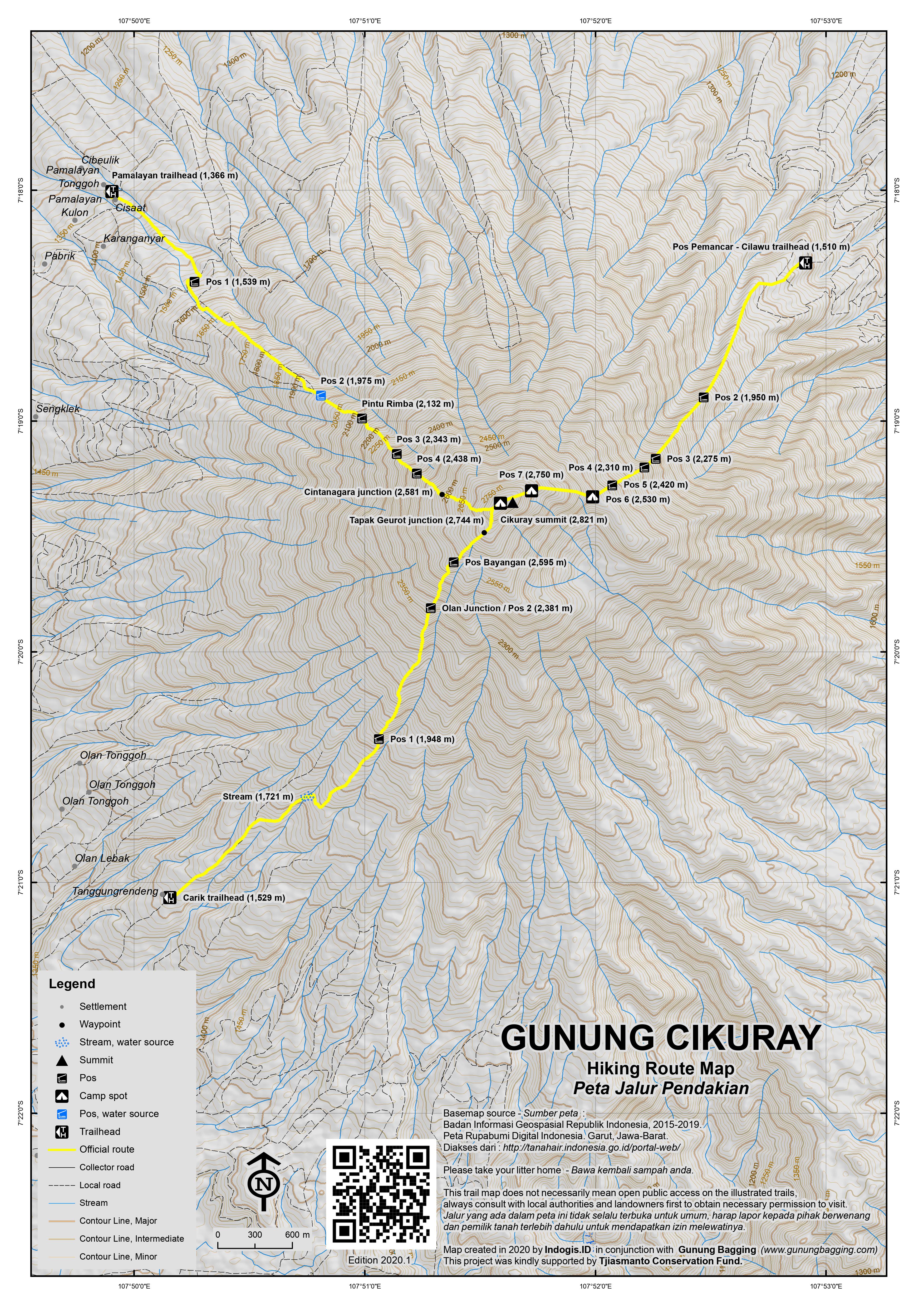
All of the following routes can be combined (i.e up from one route and down another trail) but bear in mind that if you have a guide he may need extra cash to get back round to his local starting point. None of the starting points are more than about 90 minutes from Garut by car, and some are less than an hour away. If we had to choose a good traverse, we would recommend hiking up from Pemancar and down one of the Bayongbong or Cikajang trails (where transport back to Garut is easy to find from the main road) but we haven’t yet tried the Sukamanah route.
Pemancar (Cilawu) from the north-east
Gunung Cikuray is most commonly climbed from Cilawu TV Tower AKA Pos Pemancar (1,510m) in 5 or 6 hours so it is possible to do this as a day-hike if you start very early in the morning. This very popular route has seemingly always been the most famous one and is also known as Jalur Dayeuhmanggung.
A rough farm track leading from the road at Cilawu through a tea plantation goes all the way up to the TV Tower where there is limited space to park vehicles. Ordinary cars may have trouble reaching the starting point – you definitely need a vehicle with reasonably high clearance. Given the popularity of the trail, ojeks are available on the main road. Otherwise it is a long hike in which would probably require a night on the mountain. Another thing to bear in mind is that there is no water on this route so make sure you take plenty.
At the sharp bend in the track just before the TV Tower, head up through the tea plantation. If in doubt, ask one of the many tea pickers. Soon, the edge of the forest is reached. The forest trail itself leads steeply up the side of the mountain but it is a very straightforward hike and there are several areas suitable for camping.
The Pos are as follows – Pos 2 (1,950m), Pos 3 (2,275m), Pos 4 (2,310m), Pos 5 (2,420m), Pos 6 (2,530m) and Pos 7 (2,750m). The higher Pos are usually chosen for camping because of the proximity to the summit for sunrise, but there is a lot of fairly flat space at the summit itself. Do watch out for wild pigs as there are many rather tame ‘babi hutan’ on this mountain that like to search through hikers’ food waste at night.
3 different routes from Cikajang from the south-west
This route is also known as the Giri Awas route. The southernmost route starts in the village of Carik (1,529m). The summit can be reached in under 5 hours (and under 3 for the descent). The trail leads through pine woodland before skirting past carrot and potato and finally chili fields. Pos 1 (1,948m) is simply a small flat area a short distance before the proper forest begins (2,080m). After Pos 2 (2,381m) where the Olan trail joins, the next major landmark is Pos Bayangan (2,595m) which is a lovely, sunny spot of gnarled trees (perhaps the same vaccinium species as on Salak 1). From here, you can just about see the summit cone itself. There is another junction at 2,744m where the Tapak Geurot route joins up, and then you are only a short way to the top of Cikuray.
North of Carik is the route from Olan (1,450m). Ojeks could actually go as far as 1,680m above the village. The forest begins at around 2,000m. The trail joins the Carik trail at Pos 2 (2,385m) and requires a smilar amount of time for ascent and descent.
North of Olan is the route from Tapak Geurot. The trail meets the Olan and Carik trails at 2,730m.
2 different routes from Bayongbong from the north-west
Pamalayan (1,366m). This is the most established of the Bayongbong routes. It takes between 4 and 6 hours to reach the summit. The trail leads through potato, cabbage and onion fields (and coffee plantations from 1,590m). There are occasional arrows to point you in the right direction but usually farm workers nearby to ask for help. Pos 2 (1,975m) is a basic plantation building, and the workers actually ride motobikes as far up as here so ojeks are technically possibly in an emergency. You should have reached Pos 2 in just under 2 hours. This is the only place for water, and even then it is piped water used at the discretion of the locals in the fields. The fields end at around 2,070m and the proper forest starts at 2,132m. From 2,240m to Pos 3 at 2,343m is a large open area where the trees were burnt in a forest fire in 2017. The tiny Pos 4 follows at 2,438m and Pos 5 at 2,550m. Shortly after Pos 5 is the junction (2,581m) with the Cintanagara route after which the trail flattens a little. Just a few minutes before the summit is the junction (2,795m) with the Cikajang trails.
Cintanagara. This newer route joins up with the Pamlayan route at around 2,585m and starts at a similar place and elevation.
Sukamanah from the north
The is the newest of the four principal routes and is also the closest to Garut. Assuming it has as much to offer as the other trails, it is likely to become very popular in the next few years. It joins the Pemancar route near the top. There is a large sign for this trail on the main Garut-Cikajang road about 25 minutes south of Garut.
Bagging information provided by Daniel Quinn (updated May 2018)
Trail Map
For a high quality PDF version of this and other trail maps, please download from our Trail Maps page.
Practicalities
- Getting there: For domestic flights from or to West Java, such as the airport in Bandung, we recommend Baolau. From Jakarta, take the toll road to Bandung and continue beyond to the end of the toll at Cileunyi. Follow signs to Garut and then on to your chosen starting point. Primajasa buses to Garut leave from Jakarta’s Lebak Bulus and Cililitan bus depot frequently during the day (journey time between 4 hrs and 6 hrs) and there are angkots between Garut and the main roads on both sides of the mountain. You should be able to arrange ojeks to any of the starting points.
- Guides and GPS Tracks: Want a PDF version for your phone? Looking for a guide? Need GPS tracks and waypoints? Gunung Cikuray information pack can be downloaded here.
- Trip planning assistance: Would you like Gunung Bagging to personally help you in arranging your whole trip? Please contact us here.
- Permits: Registration and tickets available at most, if not all, of the starting points. At the moment (2018), tickets cost Rp25,000 at Pamalayan and Rp15,000 at Pemancar and presumably the others are in this range. Foreigners may be asked to pay double but if you have a KITAS you are encouraged to demand equal treatment. As always, foreigners are advised to take a photocopy of their passport photo page just incase, plus KITAS if applicable.
- Water sources: In general, very little on the higher slopes. None on the Pemancar route. Usually available at Pos 2 on the Pamalayan route. Stream at 1,721m on the Carik route. In short: Take sufficient supplies with you.
- Accommodation: Try the Booking.com map above or use this link to search for suitable hotels, homestays, resorts and apartments for your trip.
- We recommend Safety Wing as travel insurance for overseas travellers and tourists hiking up to elevations not exceeding 4500 metres.
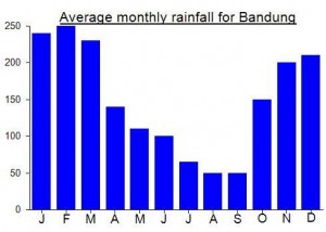
Local Average Monthly Rainfall (mm):
Location
Click on the blue arrow ![]() (top right) to see your current location on the map
(top right) to see your current location on the map
Origins and Meaning
This mountain appears to take its name from a nearby locality. Ci means “water” (usually in the names of rivers and streams) and kuray is a kind of tree. So Cikuray means “Kuray River” which presumably is a village or place, and the nearby mountain takes its name from this place. (George Quinn, 2011)
After a gap of 40 years, Garut now has a operational train station and the name of one of the new services is Cikuray, running from Garut to Pasar Senen (Jakarta). It takes 6 and a half hours – longer than buses except if you get stuck in traffic – but is incredibly scenic. Only ekonomi class seats at present. Apparently Charlie Chaplin visited Garut by train twice in the 1920s!
In 2020, most of people do not start at Base Camp Pemancar but Base Camp Pendakian.
The trail from Pemancar has become less walkable apparently.
Base Camp Pendakian is just one hill further north than Pemancar.
20.000rp fee entrance (indo and foreigners)
The route is longer than aiming for the summit from Pemancar (about 6-7 hours)
how many visitors go to the mountain in a month?
Too many these days. My guess would be at least 2,500.
As part of my revisiting of peaks I last climbed way back in 2009, I took the Primajasa bus to Garut (Rp52,000) on Friday after work for a return to Cikuray. There are so many routes on this mountain now, as hiking in Java has mushroomed over the last decade.
The bus journey took about 5 and a half hours due the usual chaos getting out of Jakarta. Hotel Alamanda in Garut was basic but friendly and central and mostly importantly with room far back from the road so fine for a bit of rest. The next morning I got a Grab bike up to Pamalayan basecamp with no trouble for under Rp50,000. Good value. Took about 50 minutes, including asking for directions once or twice.
As I waited for my guide to arrive, the locals talked about how I could actually get an ojek up to Pos 2. At the time I had no idea how far up that was but didn’t think sitting on a bike going up steep mud would save that much time or energy. But it’s a good thing to remember for if one of your group has an accident or falls ill.
This being Ramadhan I was hoping for a very quiet mountain and indeed there were just 9 others – one group – from Jakarta ahead of us. Students from Menteng. We soon caught them up and never saw them again afterwards!
It was a cloudy day but pleasant enough and we made it to the summit in 4hr 40 (with big backpacks) including a little bit of break time. It was almost deserted. Perhaps 5 or 6 people in total. The cement shelter is now painted red and white, the Indonesian flag colours. Apparently climbing onto the roof is considered naughty by some hikers, but it seems people do it every day anyway. I’m not sure I would be able to get on there without a ladder!
One thing to remember regarding trails from the summit…. one side is for Cikajang and Bayongbong, and the other side is for Pemancar and Sukamanah.
We had a lot of time to spare – the entire afternoon – so I changed clothes and had a rest in my tent down near the bushes beyond the cement building. You can fit 2 small tents or one large one in the cement structure itself. There was one large tent in there and the chap came down to me and offered me a joint with the words ‘Marijuana, Mis?’ A rare offer on the mountaintops of Java, but one I declined, for obvious reasons in this country, plus him shortening Mister to Mis (‘miss’?) in that hilarious way. It seems Ramadhan is when the outsiders, infidels and lunatics hike the mountains. Indeed, on our descent the next day, a chap was walking up from the Cikajang side with no bag, no water, no food, just wearing shorts and t-shirt and a couple of bits of waterproof material. Last year, a young man stayed up on the summit for nearly 2 months, gradually weakening and presumably living off whatever other hikers shared with him. I’m not sure anyone knows why he was up there for so long. Perhaps even he didn’t have a particular reason.
The clouds didn’t lift and we had a bit of rain. For Saturday night on Cikuray this was going to be the quietest since the previous Ramadhan. There were 8 of us in total. Perfect. No dangdut music. No inane chattering at 2am, or certainly a lot less of it!
But at 2am I did wake up, as I heard heavy snorting outside my tent. Unzipped the door and looked out. A large wild pig. Not afraid of me in the slightest, almost oblivious to my existence, just focussed on searching through my rubbish bag for any bits of unfinished food. I wasn’t 100% happy with being on my own whilst this beast rummaged around so I went up to the cement building. Up there… another surprise, a civet cat (‘luwak’). Beautiful creature, and again not especially scared. I had seen one the week before in Jakarta, like a hallucination, on a young man’s shoulder on a motorbike as he pulled in at the front of Cilandak Town Square!
I tried to get back to sleep but the wild pig (or one of his or her friends) was stomping around again. I was a little scared as if you meet one with tusks and they get angry they won’t stop until there is an outright winner or you have managed to outrun it (difficult in the dark on a mountaintop). I retreated to the guide’s tent in the cement building. Needless to say, something soon started rummaging around in the actual building right next to the tent. Maybe just a mouse, but possibly the bastard boar itself. I had a piece of bamboo just next to the tent to use as a weapon if necessary!
Thankfully all was quiet by 4.30am and I got out to find 2 more hikers (students from Jakarta) having reached the top from Pemancar. No sign of the pig… just a couple of friendly students waiting to take photos of the sunrise.
This mountain and nearby Papandayan are the two mountains that seem to have large animal populations who don’t just run away if they see you close by. Wild pigs are an invasive species in some countries, and it could be that the combination of a majority Muslim local population (i.e. very few pork eaters) and a tiny number of big cats that could or would want to eat a wild pig may mean that the population will continue to rise and rise until a cull is required. It may only be a matter of time before there is a serious incident – I have already heard of alarmed hikers running from their tents, leaving them open and returning to find them trashed, but things could be worse still!
Another guide actually showed me a video he had made at Pos 6 on the Pemancar route recently of 4 or 5 pigs in broad daylight rummaging through trash, searching for food, totally unconcerned by the presence of hikers. On mountains with few hikers the wild pigs tend to run away. Not in Java anymore it seems. No wonder there are so many farm dogs in the plantations on this mountain.
Anyway, 10 of us watched the sunrise (it would be about 500 on a normal weekend) and although cloudy the views were still impressive, especially of the Papandayan-Puntang-Kendang range and Galunggung-Beuticanar with sunlit rays.
After tidying up all the litter that the pig had scattered, we were down at Carik in just 2.5 hrs, and I got an ojek to the Indomaret at Cikajang market (Rp20,000). The road is full of vehicles heading for Garut (Rp15/20,000), a journey which takes just over an hour in a slow angkot. It was so slow in fact that I ended up getting out on the outskirts of Garut and ordering a Grab bike to get me to the bus terminal (Terminal Guntur). Norman Mohammed arrived and got me there in under 10 minutes. Terminal Guntur (‘thunder terminal’) is where the Primajasa buses leave from although you can hail them from the side of the road as long as you are on the correct road (stay to the north of the town to make this more likely!)
Would love to hear more tales about wild pigs on Cikuray…… Hati hati
Climbing Cikuray is feasible as a day trip from Bandung, assuming that you start early enough in the day.
In brief, my agenda from Jakarta for a weekend
Friday
-depart via Gambir station around 5pm arrive Bandung 8pm, dinner and early to bed
Saturday
-leave Bandung 330am
-arrive TV tower 7am
-start trekking 730am
-summit at 1130am
-down to TV tower at 3pm
-back to Bandung in time for evening train back to Jakarta Gambir at 730pm
If you want to organize a day trip up-and-down, remember the Bahasa Indonesia term ‘tek-tok’ which is commonly understood to mean up and down on the same day. Camping spaces are in high demand on the summit, evidence by the HUGE numbers of teenaged and college-aged students trekking the mountains and the large amount of trash that they unfortunately leave behind.
Cikuray has incredible views of Pangrango, Gede, and Papandayan to the west, and Ciremai and Slamet to the east, but is not otherwise a very special hike in itself. Typical of Bandung mountains it is short and very steep, meaning that in the wetter months it will be hell slipping up and down, and in the dryer months the dust will be kicked up in your face by the hordes descending on the trails. Nice for a day out but you can probably save the camping experience for a less crowded mountain.
I hiked Cikuray on March 19. It was very busy, according to the Perhutani record there were 1300 climbers visited it. Yes, you’re right, thrashes were everywhere, sad…
One thing which I was very lucky that I spotted and took some pictures of wild cat (Prionailurus bengalensis)on my inclining way at night.
I recommend that we not climb during weekends since it’s very crowded with climbers and that surely gives heavy burden to Cikuray ecosystem.
i climbed mt cikuray last week.everything went smoothly for once.normaly i try to keep things on a tight budget and take buses and ankots etc.. to keep down costs. but this time i couldnt be bothered with the cultural experience of overloaded slow buses that stop every 5 minutes looking for passengers so i shelled out and got private transport to take me to cilawu.i started at 5.00am to try and beat the congested traffic you get get between bandung and garut.i got to cilawu in 2 hours.neither myself or the driver knew where in cilawu we were supposed to turn off to go up to the tv tower.as it turns out it is very well sign posted . on the main road in cilawu you will see a green sign pointing you up the mountain with cikuray on it. i got the driver to drop me off there because i know the farm roads will be rough.within 30 seconds i had a ojek taking me up to the tv tower. ojeks will be easily found at this turnoff.the scenery through the tea plantations is very nice.the ojek ride wasnt more than 20 minutes to the tv tower. at the start of the trail there is a hut where you will be asked to leave your name and phone number and when you will be coming back.im not sure where you would find a guide but i dont think this one really needs it.the path is very obvious.only after about 500 meters up through the tea plantation could you go wrong . just make sure you head right and go for the obvious trail that runs along the ridge beside the forest.theres also a good chance that you wont be alone as this is popular with the locals so you can just tag along with them . from here its quite steep . in fact i dont remember any flat part all the way up.walking quite slowly i ended up near the summit in 4 hours.and this was with a heavy backpack with tent etc…10 minutes below the summit you will reach pos 7. this is a great spot to camp because theres plenty of flat spots for a tent and its sheltered from the wind and rain. i reached the summit by 12.00pm and in hindsight i wished i had done this one as a one dayer to save taking the heavy backpack up. but the tradeoff was being able to wake up and get a great sunrise .the views were a little hazy but even then i could see slamet smoking away in the distance. also ciremai,guntur,papandayan with a full moon over it,beuticanar . the cement shelter has had a garish green paint job since dans picture. downhill took 3 hours to the tv tower and my ojek driver was waiting for me.good idea to ask your ojek to come up the next day to save you a 2 hours walk to the main road. from cilawu back to bandung i took a ankot to garut and then the bus back to bandung.taxi in garut wanted Rp 500,000. a bit steep considering the bus was only Rp 30,000
overall a great hike and well worth doing. the negatives would be the trash on the mountain.and also a lack of wildlife .barely a bird in sight. 6 more to go for hall of fame.
Hi,I climbed Gunung Cikuray a few day ago as a one day trek. I started from the road Garut-Tasik at 7am (RM Ibu Hani) and after two hours I reached to the communication towers area. The walk is really nice, going through tea plantations and with many butterflies. From there I started the real ascent to the summit and reached the top at 11.30. Half an hour there and then went down. I walked quite fast and finishedbefore 4pm. I saw a lot of people loaded with huge and heavy backpacks who camped for 2 nights. The final 3km ascent is very steep and not comfortable to do with a big backpack, so take only the necessary and please collect your rubbish because the track and camping areas are full of garbage.
We climbed Cikuray on October 1st 2011.
The car journey from Jakarta to Garut takes 4 hours- 2.5 hours to Cileunyi and 1.5 hours from Cileunyi to Garut. (Be careful on the long slow descent after you cross the railway tracks; the road to Garut forks right unexpectedly as you near the bottom, though a new road is under construction.)
We stayed in Cipanas in Hotel Cipta Bela 2, down a back alley behind the upper car park; for Rp100,000 it offers a room with a garish paint job, bathroom tank big enough for two and a malfunctioning TV.
There appear to be three routes up Cikuray- from Cilawu in the northeast, from Bayongbong in the northwest and from Cikajang in the southwest.
Ever keen to check out new routes for the benefit of Gunungbagging readers, we chose the Cikajang approach. Besides, on Google Earth it looks like you can start from higher up the mountain on that side.
Although this route is sometimes called the Giriawas route, after the nearby tea plantation, the place you actually need to get to is Olan, a small village with a pesantren at 1450m altitude; turn left at the alun alun in Cikajang and head upward for 4km. Allow 60 minutes from Cipanas to Olan.
If you need a guide, it would be a good idea to scout around in villages on the way up the road as villagers in Olan are busy in the fields. Eventually though we persuaded an Olan villager Dede to leave his cows overnight and join us for a night on Cikuray.
We started hiking from Olan, but an ojek or 4WD could carry you up the farm track beyond the village as high as 1680m. At the end of the farm track is a valley with several footpaths; turn right to climb up onto the ridge on the right side of the valley.
There are numerous trails from this ridge leading into the forest. If you don’t have a guide you’ll need to ask as many farmers as you can find, or staying on the center of the ridge should keep you on the right trail.
The forest begins at 2000m and there is a junction where you turn left at 2160m. The trail is narrow and steep and requires plenty of scooting under tree branches, skipping over roots and skirting around landslides. With our newly-imported “Craghoppers” pants we had visions of bounding merrily over all obstacles, or at least not getting that feeling of sweaty fabric clinging to the thighs, but the gradient was still far from comfortable. Next time I’m going to wear lycra stretch pants like the ladies wear for yoga, and damn the fashionistas!
There is a campsite at 2410m and another at 2610m, where the trail emerges onto a ridge. Thereafter, the gradient slackens off slightly and the route proceeds pleasantly up to the summit. A path from the left, perhaps from Bayongbong, joins up at 2740m, though the main Bayongbong trail comes in from the left later, just before the summit.
The last section of the ridge below the summit is broad enough for lots of tents. There’s more camping space around the cement shelter on the top, but we chose a more sheltered site just below the summit on the east (Cilawu) side.
Ascent time was 4h30, giving us a whole afternoon to while away cooking, chatting, doing yoga and clambering onto the cement shelter roof to admire the panorama of clouds. Descent the next day took 2h30, so this would be a comfortable day hike.
Cikuray was busy, with some 40 people there enjoying a SAturday night out. All except us had come up from Cilawu; they reported ascent times of 1h30 up to the TV tower, plus 5 hours or so from the TV tower to the top.
We also heard that there used to be an air traffic control signal transmitter atop the mountain. But a few years back it was stolen along with the steel perimeter fence.
Let’s hope nobody steals the cement shelter! It would have made a great perch for photos if the clouds had actually lifted in the morning. But they didn’t, depriving us of the hoped-for views to Papandayan and Ciremai. We hikers need a weather website advising us when the views are going to be clear!
From my experience. It took 2 hours from Cilawu to Tower by foot. And took 7 hours from tower to summit (night) and 2 hours down to Tower
how long did it take from Cilawu to TV tower? What time of day did you start and what time did you reach the summit?
From vague memory less than an hour from Cilawu to TV tower. Took about 4 hours to the summit walking reasonably quickly. 3 hours down. A straightforward daytrip from Bandung as long as you set off before daylight.
Just for information. Actually u can take ojek from Cilawu to TV Tower, it will cost u around Rp 30.000. But, i did hike from Cilawu to TV Tower. Steep but was great