Facts
- Elevation: 2,276 m (7,467 ft)
- Prominence: 1,088 m
- Ribu category: Tinggi Sedang
- Province: Bali
- Google Earth: kml
- Rating:


 (13 votes) Add your rating
 Loading...
 - Other names: Batukau
Photos


Bagging It!
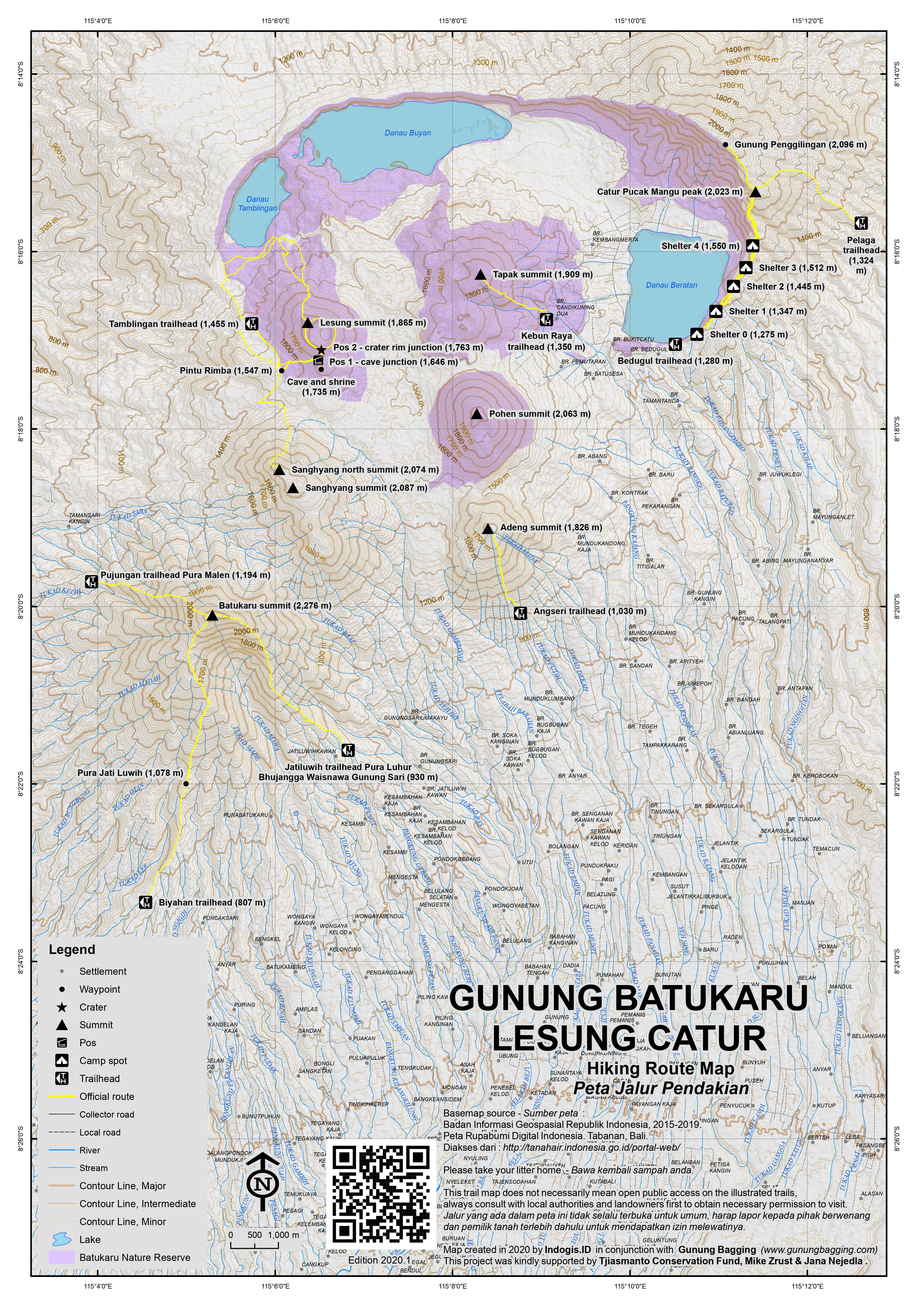
This Ribu is Bali’s holy western mountain and is one of the wildest areas on the island. It is actually the highest mountain of a large massif consisting of multiple peaks including Gunung Catur / Penggilingan (2,096m), Gunung Sanghyang (2,087m), Gunung Pohen (2,063m), Gunung Tapak (1,909m), Gunung Lesung (1,865m) and Gunung Adeng (1,826m).
Like all these peaks, until quite recently Gunung Batukaru was rarely visited by anyone other than local people who climb to the temples at the summit but there are now in 2020 more people interested in hiking just for the sake of hiking so there is a moderate chance of meeting other groups on the mountain. There are several trails on its slopes which are in reasonable condition. The name means ‘coconut shell’ in Balinese and there are hot springs and three craters on other parts of the large mountain massif.
Gunung Batukaru is nowhere near as popular as Batur or Agung although the summit area has been cleared and there are some excellent views from the higher slopes to the easternmost Java peaks in the west to Agung and Lombok’s Gunung Rinjani in the east.
Camping is possible at the summit but many make it a long day-hike, starting at first light. There are various routes as follows.
Pura Batukaru route
Historically, the most popular route was the one that leads from Batukaru temple (Pura Batukaru) which is known as Jalur Wongaye Gede. The Pura Lahur temple perches at 823m at the end of the steep road north of Meliling past Wongaya Gede. This was the state ancestral temple of the Tabanan court, and each of the shrines represents a different dynastic ancestor. It usually takes 4 or 5 hours to the summit of the mountain and 3 and a half hours to descend.
However, whilst this route would appear to be the most commonly used, it is very unfortunate that the staff at the temple office have begun to gain a very bad reputation indeed, particularly when dealing with non-Indonesians. They are very unhelpful towards would-be hikers – ridiculous sums of money have been demanded for a guide (which they consider to be obligatory), they will claim that you require permits from various local authorities, and to get onto the trail to the summit itself from the temple car park you have to enter the temple area (for which wearing a sarong is required).
Therefore, the other routes below are recommended instead and are growing in popularity.
Jatiluwih route
This trail is in good condition and the starting point is a very peaceful and picturesque one. To get to the more hassle-free starting point near Jatiluwih it is best to have a local driver who knows the area as the roads up in the hills north of Tabanan are quite difficult to navigate. The trailhead is at another temple – Pura Luhur Bhujangga Waisnawa Gunung Sari (930m).
Broadly speaking, you can either head west for 30 minutes from Baturiti on the main road traversing the island north-south from Singaraja to Denpasar or head north up a complex system of narrow roads from Tabanan. Jatiluwih is a popular spot for day excursions as the panoramas of rice terraces are some of the finest on the island. Staying in the area is possible as there are many hotels.
You could try asking for a guide here but it may be better to try doing so in advance. From the main road near Jatiluwih (at 759m), there is a road leading up the mountainside, but it has no signpost so ask for the temple which is the highest point you can drive a vehicle to.
There is enough space for a couple of cars to park just before the temple. You shouldn’t have trouble getting directions from local people, but if you do, ask for the hen farm – which is halfway up the road to the temple – and stay left at all junctions. There are one or two spots where the road surface is very rough but a regular car should be able to manage it.
There are temples every 200 metres or so but Luhur Bhujangga Waisnawa is by far the most elaborate, featuring one structure with an 11-tiered roof! If you have travelled by ojek (motorcycle taxi) you could actually continue up a narrow cement track past another temple with an excellent view of Gunung Batukaru peak above, up through farmland to a further temple with two painted tiger statues underneath yellow and white umbrella sun-shades (956m). From here, the cement track ends and the hiking trail begins.
In a couple of minutes, and just before the trail enters the forest, you will reach yet another small temple structure with another two yellow and white painted tigers (985m). This suggests that the rumours of big cats still living in the Batukaru forests might well be true. The trail then leads pleasantly up through the forest though the only signs are inaccurate elevation readings. There is not much litter – mainly because not many people use the trail – and the path is very clear for the most part. At 1,432m there is a small junction – stay left (straight on up the mountain). There are a few steep and muddy areas but the terrain should not present any problems to fit hikers.
After about 3 hours of delightful forest hiking, you should have reached about 2,000m elevation. From this point, the trail gets a lot more overgrown – there is a lot of bracken and dense undergrowth to climb through – but the route remains obvious. The final hour of climbing is quite exhausting but the narrowness of the ridge is very impressive – if there was no vegetation to hide the sheer drops here it might even be quite scary! If you are on the way to see the sunrise then by now early daylight will have given you a first glimpse of Bali in every direction. Finally, after about 4 or 5 hours you should have reached the grassy summit area. The summit is home to various shrines which are the final destination for many pilgrimages from villages surrounding the mountain.
There is a lot of space here for tents but you may well find that the summit area itself is covered in vast amounts of litter and offerings left to rot – a real shame that local people do not take their litter back down with them. Indeed, there was even a dog up here when we camped, going through the litter looking for food and howling all night!
However, the views in clear weather are astounding – mountains in East Java including little Baluran and large Ijen-Merapi and Raung, the north and south coasts of Bali, Lake Tamblingan to the north, Gunung Batur and Agung to the east. In very good weather you should be able to see Lombok’s Gunung Rinjani in the far distance, just to the right of Agung. It is a fabulous panorama. The Bakosurtanal map suggests a summit elevation of 2,271 metres but GPS data is in support of 2,276m or even higher.
You can return the same way in about 3 hours, or if you are feeling adventurous you could descend to Batukaru temple, which takes a similar amount of time.
There are a lot of leeches on this trail so make sure to check your clothing every half an hour. The trail is slightly monotonous and muddy but especially on the way down you will be able to admire many species of mushrooms, a large variety of ferns and some amazing huge trees. The first landmark of any note on descent to Batukaru temple is a cement pillar at what is sometimes referred to as Pos 3 (1,867m). Shortly afterwards is Pos 2 (1,594m) with a curious ‘Seacology’ stone tablet and a minor trail leading off to the right (don’t take it – stay on the main trail!). There is another open area where people probably stop for a rest at 1,437m but it is not recommended because of the number of leeches in this forest! There are some fallen trees at 1,207m but they are quite easy to climb over if you take care and go slowly. The trail then flattens out and the final 45 minutes of descent is very pleasant though incredibly humid virgin forest.
Eventually you will reach the edge of the Batukaru temple complex. Given what has already been mentioned above, it is better not to take a left down to a river and then up cement steps to the comple itself, but rather follow the trail further down to beyond the temple and into local villages.
This trek is ideal for adventurous hikers who have perhaps already climbed Agung and Batur and are looking for something a little more isolated and want to enjoy new panoramas of the island.
Three other routes to consider
The mountain can also be climbed from the south at Biyahan (807m). This trail, known as Jalur Sarin Buana, leads via Pura Jati Luwih (1,078m) – not to be confused with Jatiluwih itself! It joins the Wongaye Gede route about halfway up.
Another trail from Pujungan (1,194m) in the north-west starts at Pura Malen temple. It is known as Jalur Pujungan Pupuan.
Finally, there is a route up from the south-west known as Jalur Sanda, but it is currently not well-known.
Bagging information provided by Daniel Quinn. With thanks to Heinz von Holzen
Gunung Catur / Gunung Penggilingan (at least 2,096m)
The so-called fourth-highest mountain in Bali (after Agung, Batukaru and Abang) is the highest point on the rim of the Bedugul or Beratan caldera which contains the large lakes of Danau Tamblingan, Buyan and Beratan. It lies to the north-east of Batukaru and is rather like a twin of Gunung Abang in terms of its topography.
There are two main trails up to Pucak Mangu temple which is the main target of hikers in this area. You can follow the forested rim from near Goa Japan (Japanese Cave) on the southern shores of Lake Beratan (1,255m) on the outskirts of Bedugul or head up from the trailhead / forest entrance (1,324m) beyond Pura Pucak Manik temple (also around 1,250m elevation) which is to the south-east of the peak in the village of Pelaga / Plaga. The Pelaga trail is shorter but perhaps less interesting.
The Bedugul / Danau Beratan trail requires around 3 hours up and 2 hours back down again. After the end of the road, take a left into forest (1,280m) before reaching the first shelter (1,275m) which we will call Shelter 0 as motorbikes can actually be left here rather than at the road end. From here the trail is obvious except at one point (1,310m) where you must go straight (left instead of right) at the fork.
There are four more shelters on the trail as follows: Shelter 1 (1,347m), Shelter 2 (1,445m), Shelter 3 (1,512m), and Shelter 4 (1,550m), all of which actually offer some shelter in the event of heavy rain. After the shelters, the trail begins to get considerably steeper, but you are rewarded with occasional panoramas of the lake below and the Batukaru mountains to the south-west.
Just before Pucak Mangu is what appears to be an old landslide area, with a bit of rope to help you up and also a fantastic view. Then is Pucak Mangu itself where the Pelaga trail meets this one. There is a shelter and enough space for several tents.
The most common elevation figure given for Gunung Catur is 2,023m, but this refers to Pucak Mangu temple which is not located at the highest point. Indeed, according to the Bakosurtanal map, ‘Gunung Mangu’ is only 2,020m.
The true highest point is around 1 kilometre further north along the rim and is known as Gunung Penggilingan with a height given on some maps and signs as 2,096m. Beyond Pucak Mangu the trail is a little more overgrown but most hikers will be able to reach the small shrine on Gunung Penggilingan in around 40 minutes (one way).
It appears that the rim could actually be followed all the way round to the north-west at Pura Yeh Ketupat near Danau Buyan but an experienced guide would be very much recommended for anyone attempting that. According to the Bakosurtanal map, the highest peak of Penggilingan is just off to the right (east) of the rim and 2,153 metres high which would put it above Gunung Abang and therefore the third-highest mountain in Bali. A second spot height further along the rim to the north-west is given as 2,105m.
The highest reading we got on our GPS at the Penggilingan shrine and sign was around 2,106m, which given the +/- 10m accuracy of these devices supports the 2,096m figure. We couldn’t see this 2,153m peak through the trees and reckon it might be an error, but there was another peak of a similar height to the north-west – perhaps the 2,105m spot height. If anyone discovers the 2,153m peak please let us know!
Gunung Lesung (1,865m)
Another peak very much worth exploring in this area is Gunung Lesung (1,865m) which lies to the south of Lake Tamblingan. Anyone who has seen this on a topographic map will have noticed the wide, deep crater with the very evocative name of Lubang Nagaloka (“The Dragon’s Hideout’). Despite being a short hike it is not very popular yet the trails are clear and a circuit of the crater rim is possible.
You can hike straight up to the summit from the north on the southern shores of Lake Tamblingan or take a bike further up plantation tracks to the west of the peak. The plantation tracks disintegrate higher up to it is best to leave motorbikes at around 1,424m where in clear weather you can see the easternmost mountains of Java in the distance. From here, continue up the trail past a couple more simple plantation houses before reaching the col with a view of Gunung Sanghyang (2,087m and also accessed from here) and taking an unsignposted left/east turn into the forest (Pintu Rimba, 1,547m).
Pos 1 (1,646m) is soon reached. A tree is draped in ceremonial cloths and the trail going off to the right here leads in just 5 minutes to Goa Lubang Nagaloka (1,735m) which is a small shrine above a deep and pitch-black near vertical pit, or hole, or indeed ‘cave’. This is definitely worth visiting, perhaps on the way back down. Be very careful not to get too close as it would be very difficult to get back out again!
Beyond Pos 1 the trail continues up the side of the mountain to Pos 2 (1,763m) which is the crater rim junction. According to the Bakosurtanal map, the crater floor is at 1,667m so it is around 100 metres deep from the lowest part of the rim. In 2020 there was a very faint trail leading down from Pos 2 and a second trail leading down about 100 metres further east (anti-clockwise) so the crater floor can seemingly be reached.
There appears to be no volcanic activity here now and the few glimpses between the trees down in the ‘dragon’s hideout’ reveal dense vegetation. It’s perhaps Bali’s most mysterious and isolated spot.
From Pos 2, the quickest way to the summit is to head left / clockwise because the summit lies on the north-western part of the rim, but as a full circuit of the rim is very much recommended either left or right makes sense. The finest views are on the rim both before and after the summit with the best being an excellent panorama of Bali’s western mountains and the easternmost volcanoes of East Java. This is most likely in the early morning.
Like most mountain summits in Bali, the peak is marked with a shrine and a hiking club sign. It’s a pleasant spot to take a rest and it should not have taken you more than 2 hours or so to reach this point. Going down takes a little less, except of course if you visit the crater floor or descend using the other route from the lake.
Trail Map
For a high quality PDF version of this and other trail maps, please download from our Trail Maps page.
Local Accommodation
Featured Guides
If you are a reliable local guide and would like to be featured on this page to increase your bookings, or a tourist who would like to support the development of a local guide business, please email danpquinn@gmail.com with the following information: Mountain name, guide name, guide location, guide contact details, and at least one English language review from a previous hiker who was pleased with the guiding services. An example is given below for reference. We have a maximum quota of 3 featured guides for each mountain page on the site. The fee for this is £20 (British pounds sterling, typically via the Wise app or PayPal) for a period of 1 year and helps to pay towards the ongoing development of the Gunung Bagging project.
- Name and location: Pak Budi, Surabaya, East Java.
- Contact details: +62812xxxxxxxx, budi@gmail.com, https://www.instagram.com/budi_mountain_guide/
- Review from previous client: “Budi was a brilliant guide for our September 2023 trek up Gunung X and I would definitely recommend him to other tourists“, John, USA.
Practicalities
- Getting there: Car hire is easy and cheap in Bali and drivers should know the starting points.
- Guides and GPS Tracks: Want a PDF version for your phone? Looking for a guide? Need GPS tracks and waypoints? Gunung Batukaru information pack can be downloaded here.
- Trip planning assistance: Would you like Gunung Bagging to personally help you in arranging your whole trip? Please contact us here.
- Permits: Not necessary but have a photocopy of your passport just incase and, if ascending from Batukaru temple, be prepared to deal with some stubborn people!
- Water sources: Take sufficient supplies with you.
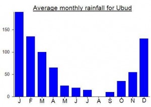
Local Average Monthly Rainfall (mm):
Location
Origins and Meaning
Batukaru has a large crater, the largest in Bali, but this crater is open at the southern end, allowing the river Mawa to escape. It is this that gives it the name “Batukaru”, which means “coconut shell” in Balinese. (Wikipedia, 2011)
Links and References
Wikipedia. 2011. List of mountains in Bali. Accessed from http://en.wikipedia.org/wiki/List_of_mountains_in_Bali
I’ve climbed Batukaru a few days ago starting from Pura Siwa / Malen on the west side of the mountain. Reading the other comments I can highly recommend this route. There’s a “office” at the start where you pay 50.000 IDR and register your name. From there the path goes up all the way to the top and is very easy to follow. It took us 3 hours up where we had beautiful clear views (started at 6am). Getting down took little over 2 hours. You need to be fit as it’s moderately steep but very doable and enjoyable. It’s a beautiful experience!
It is possible to do a full circuit from Puncak Mangu to Penggilingan and onwards, traversing the rim and descending at Yeh Ketipat Temple.
I climbed to the summit of Penggilingan from Yeh Ketipat, and thus can confirm its possible to traverse the whole mountain range.
Total trek was about 3-4 hours on ascent. Right next to Yeh Ketipat Temple, there is a road (big enough for cars) going up. Keep following the road until you see a telco tower on your left. Park here. On your right, there are two trails. Left one is stone path, right one is stairs. Take the left one.
Then keep going through the local plantation. Path isn’t very clear due to tall grass, but your point of reference would be another telco tower higher up the hill. Once you got here, walk past the tower on its left side, and you will see a clear path entering the forest. This beginning part is what made this route uncommon; difficult to find the starting point!
Once entering the forest, path is extremely clear. You will have 2 small but flat resting area en route. The first one is about a quarter of the way, about 40 mins leisure hike. After this, route branches into two; take the right path. This is the only branch in the route.
The route becomes very pleasant, almost flat, until reaching the second post (about halfway to Penggilingan summit). Here, I recommend resting, because there will be almost no other open place to rest after this until very close to the summit, and the heavier part begins.
The route turns a little treacherous. One steep ascent, some relatively flat area, then a very steep and long ascent (a little scary on the way down as its all soil and slippery roots; no ropes to help). Once passing this second ascent, you will start a long skim through the rim. Some parts are intimidating as you have a very sheer drop to your right, and apparent past landslides. Fortunately, the vegetation is thick enough to hide the sheer drop, so just watch where you step.
There will be minor treks branching off leaving the rim; ignore them and just keep skimming the rim.
The third post is a flat area with open views to your right. At first, you’ll see Beratan Lake. But keep going just a little bit and you will have a full view of Lake Buyan.
From here, it’s probably just 2 minutes walk to reach Penggilingan summit.
– No water source along the way, bring enough.
– At the time of my climb (25th April), there was no leech (though judging by the trail condition, some parts are likely to have them in rainy season)
– I would re-stress this, once at the rim, be careful where you step especially at the landslide area
GPS Information
Parking area (starting point)
8°14’12.5″S 115°09’24.2″E
https://goo.gl/maps/nj7SD929gxRuh5wd7
Post 1
8°14’18.8″S 115°09’49.6″E
https://goo.gl/maps/32LkByRb3DdYxm9g8
Post 2
8°14’22.4″S 115°10’19.2″E
https://goo.gl/maps/qLzEiX26AnnM5xZW6
Post 3
8°14’46.2″S 115°11’02.3″E
https://goo.gl/maps/TxnJw6RaHdhC3uoUA
Bali is quite different at present as might be expected. International tourists not allowed in for obvious reasons, and even domestic tourists are showing little interest so far. Of roughly 3 return flights from Jakarta per day with Air Asia it seems usually only 1 is operating.
Interesting that Grab now have a seating area outside the airport and that they are allowed to operate without fear of getting beaten up! However, it comes at a price, a ridiculous price. The app quoted Rp692,000 one way to Bedugul. Given you can hire a car and driver for the day for under 500,000, who on earth is going to go along with that other than ignorant tourists totally unaware of how abysmally they are being treated? We took a regular taxi driver whose first quote – 400,000 – seemed fair enough. He had had no other fares that day and was clearly struggling given how keen he was that we used him on the way back 2 days later.
I had two hikes planned, both starting pre-sunrise, both finished by mid to late morning, both in the Bedugul area.
First up Gunung Lesung, which just has to be explored by anyone who sees the deep crater on a map. There are few signs on the trail but it is clearly visited fairly regularly. We did a circuit of the rim, peering down into Lubang Nagaloka, but without enough time to actually try going down and back up out again, though that would make a great day assuming you have a guide who has done it before which might be hard to find except in the plantations!
We were lucky with the weather and had an amazing view to West Bali and easternmost Java near the summit. A highly recommended half-day outing. Lots of birdlife too.
The following morning was spent on Gunung Catur. Very similar in terms of height, topography, views and summit to Gunung Abang. In short, very pleasant. We continued on to Gunung Penggilingan which took about 40 minutes from Pucak Mangu where there was one group of local hikers camping. Highest GPS reading was about 2106m but certainly couldn’t spot the 2153m knoll featured in the usually accurate Bakosurtanal map. That said, the forest does restrict the view a little. A proper traverse all the way down to the north might clear things up but once again you’d need a full day for that instead of being back down for lunch!
Finally managed to climb to the summit of Batukaru after 2 failed attempts back in March. The top was way to overgrown back then and not enjoyable at all. Fast forward to October and its still a little overgrown but nothing that would stop you getting to the top.
I started the hike at 5am from the Taksu temple near Jatiluwih rice terraces. I read that there had been fires on the summit and that hiking was banned from the more famous and well described temple in the notes above. That means that the Indonesians are now hiking from Jatiluwih side. I passed 3 Paks and 1 Ibu, all about 60 years old hiking up with offerings and barefoot!
I reached the summit in 2 hours and to my absolute surprise there were 2 ducks and 1 chicken on the summit! I couldn’t believe my eyes but its a special ceremony going on here where they sacrifice the ducks. Seems nonsense to leave 3 animals at the top with no food or water. I would have bought them down with me but I had no way of carrying them let alone trying to catch them.
The summit area was pretty rubbish free but run down temples and burnt metal boxes litter the top. There is what looks like a weather station and there are 2 surveillance cameras up there aswell. I saw this on Merbabu aswell not sure what they are recording up there. I took the same way back and was down in an hour, 3 hours for the total trip. I didn’t stay long on the top as it was blowing a gale.
I´m Planning to hike batukaru soon with my local friend (and trekking-guide). Thanks for all the infos here! Are there any leeches in the djungle?
Cheers J
Hi there, so we just hiked batukaru without a guide the last weekend. Starting point was at Pura Luhur Taksu Agung (easy to find in google maps). It was a good hike (you need to be fit!) and we met a few very friendly lokal hikers in the jungle. We wrote a post in our blog (in german): https://thehiketribe.com/de/batukaru-besteigung/
Cheers Jan
I climbed from the Pura Luhur Taksu Agung temple near the Jatiluwih rice terraces. I parked my scooter there and left just after 5am. It took me around 90 minutes to get to 2100m but then the path became extremely overgrown and very easy to get lost. I carried on and reached a high point of 2190m before deciding to turn around. I didn’t want to end up like Owen Hendersen who has left his account in the comments below.
It would be extremely easy to become lost in this area as there are numerous down trails and the main trail is so overgrown you wouldn’t even know it was a trail. The Last section I completed had a lot of up and down and my GPS said I still had 400m until the summit. With the over grown nature of the trail I’m guessing this would have taken at least 30 minutes or more.
It wasn’t fun anymore at that point so I decided to call it a day and go down. Total time was 2h40m bike to bike but the last section will add a significant amount of time. Totally bummed I didn’t make it to the top but it was just getting too miserable in the thick Bush.
Around half way I saw 3 deers with white tails dash off into the Bush at break neck speed. Totally wasn’t expecting to see any animals but they are up there in the hills.
Side note : There is a really friendly guy working at the temple where the path starts. He offered me coffee and we had a good chat. Drop in and say hello if you pass by.
I went for a motor bike ride to check out the Batukaru temple just by myself. When I got to the temple there was not a person to be seen. I noticed a trail that lead toward the top of the mountain so followed it. After about 5 hours of climbing in thongs I got to the summit but it was very misty and cold with very thin air. It was also very quiet and kind of spooky. It started raining and I could only see a few metres in front of me because of the very thick mist.
I became very lost in the mist and descended for about 2 hours to far to the east along a ridge with a sheer drop to the left. Trying to head west through extremely thick jungle and on the very steep slopes I lost my footing around 5 times and fell through the roots and vines eventually stopping myself on each occasion by crashing into a substantial tree. My westerly direction of travel became blocked by a huge gully created by water flowing off the mountain. I had no choice but follow the gully which was made of very slippery solid rock like a huge slide. I sat on my buttocks and with my feet stretched out in front of me to act as brakes I slid down the gully for about 2 hours wearing a hole in my board shorts. I also lost my footing several times and slid out of control at high speed only stopping from crashing into a rock face where the gully changed direction.
After traversing several smaller water falls where the rock face were vertical I came across a very large water fall that I could not climb down so headed back into the jungle to bypass the water fall. At the base of this large water fall I found a track that headed to the west so began following the track for another hour as the sun was going down. Luckily the track came out at the very top temple where I cleaned myself up washing off the blood and mud and removing several leaches attached to my legs. Apart from the cuts and bruises the vines that I had fallen through were stinging nettles and across my face, neck, arms and legs I had huge welts full of thorns that had a severe sting.
I eventually made it back to the motor bike after dark and took several days to recover from my injuries.
I’m a solo traveller looking to trek this mountain around the 7th of December. Anyone knows a reliable tour guide/company that would be willing to take me? Wouldn’t mind joining a group too.
Hi everyone,
I am planning to climb Batukaru next June, from Jatiluwih as it seems there are some thugs at the temple.
Is it possible to continue down on Tamblingan lake side?
there are enough other mountains – where you dont have that troubles 🙂
take a look at
http://www.mountains-of-bali.info
Dan,
The same thing has happened to me at Gunung Batur (which is a straight forward ‘walk to the top’ mountain as I know you are aware of). The head of the Kintamani climbing association started huffing on about how it would take 500,000 rp per person to make a 2 and a half hour climb at best. Of course we would be paying for so called insurance and what not. He then proceeded to pull out an assortment of certified documents and started waving them around in front of our faces. We didn’t budge and we got the price down to 350,000 rp. I know that you are talking about Batukaru; however the same thing happened to us at the mother temple ‘Besakih’ near the base of Gunung Agung. The whole bit about how you must hire an obligatory guide to enter the temple. I saw a German fellow who refused to hire a guide and the locals grabbed his collar. We can always say that this is Indonesia and we must deal with that kind of behavior, but when I went to the Vatican, I wasn’t greeted by thugs demanding payment for entrance and you certainly couldn’t buy beer and cigarettes inside like you can at Besakih. I think that enough time has gone buy and enough international tourism has taken place for some of these local administrators and government leaders can start thing about quality control. Otherwise, they will cross the wrong person and word will get out about their thuggish demeanor. I love Bali but they could definitely be savvier about how they handle tourism or the island will inevitably wind up like Ibiza, Spain.
Yeah I had similar experiences with a local bully at Besakih. Luckily we had a great guide sorted out anyway. They always tell you horror stories about foreigners who never made it back yet they themselves never take a compass or map, let alone any first aid! I often wonder if the reason there are never any signs is because if there were then there would be no need to pay a local two weeks of wages to climb a hill with you! Luckily GPS tracks are making it a lot easier to go and get on with it individually (though obviously it’s a terrible idea to climb alone, not that I haven’t done it a few times myself).
I suppose many people would agree that unfortunately Bali is a hotspot for local morons trying to make a quick buck from ‘foreigners’. They are a minority of the population but in places like the temples mentioned it can really create an impression that everyone on the island is out to milk you to fullest extent possible and there is little concept of a fair price for a job well done! It’s the highest price for whatever they can get away with! That’s capitalism though eh?
The problem with local government making it more official is that it would probably not help much – it would just be even more expensive as another layer of bureaucrats want a cut. My most enjoyable experiences are always in places where there are not daily coachloads of tourists hanging around anyway and you can just find a local willing to give you a hand rather than requiring vast sums of cash and/or permits. As for Batukaru, there is no problem going up the rather more obscure route mentioned above (but finding a guide there could be tricky). My Batur experience, on the other hand, was hassle-free and I get the feeling things are beginning to improve there.
Climbed Batukaru on Sunday afternoon, camped at the top and descended Monday morning. Some amazing dawn views and enjoyable forest hiking – didn’t really feel like Bali as we didn’t meet any other hikers and it was very wild in places.
Anyway, whilst the hike was very good, dealing with the people at Batukaru temple was very bad indeed. I was climbing with a friend who has lived in Indonesia for many years and has already been up Batukaru 6 times and knows the trail from Batukaru temple incredibly well. He needed to leave his motorbike at the temple so he spoke at the small office at the temple and was happy to pay a feee for leaving his bike there overnight. Of course, they first starting telling us we must take a local guide (at a ridiculous price), that the weather was not good enough to climb in (a little bit of rain) and that we need permits and permission from village chiefs and local police etc etc etc. This is, of course, simply a way to try to get money out of us for as many of them as possible. After 90 minutes of ‘negotiating’ my friend had still gotten nowhere and were running out of time (I having flown in from Jakarta that very morning in order to specifically climb this mountain!). I was expecting to have to delay the hike until the following day and try to find a different approach with more reasonable local attitudes but my companion said that we would do it anyway (we were all ready, with tent, food, GPS etc etc). So, the farce began – we made the obligatory ‘donation’ to the people that ‘hang around’ at the temple and put on the sarongs that are mandatory for entering the temple area. We then descended down to the river where the trail to the summit begins, took off the sarongs and put them in our bags, and set off up the mountain.
It was a great hike and the following morning we descended via a different route to near Jatiluwih – a much better route for avoiding the nasty mercenaries at the Batukaru temple.
I later asked my friend what had happened the following day when he returned for his bike. Well, it turns out that two brand new nails had been put through his motorbike tyres and they were completely flat. He then had to walk for several kilometres to get his bike fixed – I imagine it wasn’t cheap either.
So, a word of warning, do not climb this mountain from Batukaru temple as the people there are abhorrent. I will be writing an update shortly with details of the alternative and much more peaceful route.
It is a real shame when things like this happen – and it casts a very dark shadow over some of these bullies who seem unwilling to be reasonable with ‘foreigners’ and would appear to be solely motivated by whatever money they can cadge from visitors to the temple.
Any recent news on Batu karu climbing? I really want to climb this mountain this year…Please let me know if anyone has any leads on reasonably priced local guide. Cheers. 🙂
Just had my first look at your website and it’s great. I live (retired) in Bedugul, Bali right next to lake Beratan. I’ve already climbed several peeks over 1000m including Naga Loka and Catu. Batukaru is on my “next to do” list, but as yet haven’t found anyone who knows the routes. I fancy starting for Batukaru temple and finishing in Tambilingen. Probably two days. If you’ve heard of any good guides, I’d love to hear from you. Regards Jeff