
Facts
- Elevation: 1,717 m (5,633 ft)
- Prominence: 461 m
- Peak category:
 Spesial
 - Province:
 Bali
Bali - Coordinates: -8.2372, 115.3769
- Rating:


 (10 votes) Add your rating
 Loading...
 - Eruptions: 1804, 1821, 1849, 1854, 1888, 1897, 1904, 1921-22, 1924-26, 1963-66, 1968, 1970-74, 1994, 1998-2000
Photos


Bagging It!
The mountainous region around Kintamani, centering around the spectacular volcanic caldera of Mt. Batur with its deep crater lake and bubbling hot springs, is rugged with high and wild beauty. Clean crisp mountain air and stunning views in all directions are what makes Kintamani one of the most visited tourist stops in Bali. Batur is a truly fabulous volcano, consisting of a ‘double caldera’ – one crater inside another. Nearing Kintamani, the land rises steadily towards an almost featureless horizon – with only Gunung Agung and Gunung Abang in view to the east. The volcano rim has a diameter of over 14 kilometers and down in the crater sits the blackened cone of Gunung Batur, surrounded to the right by the long, blue waters of Lake Batur, and on the left the lava fields created by relatively recent volcanic eruptions, and very fertile vegetable plantations.
The great size of the crater implies that Mt. Batur was once a much bigger mountain – perhaps as big as nearby Gunung Agung – which blew its top thousands of years ago. The volcano is still active – the last serious eruptions occurred in 1965, 1974 and 1994. Erupting from the lower west flank of the mountain and leaving a vast field of black needle sharp lava rock that is now harvested by the tones as building material. As I write this story in January 2010 the western side of the volcano has once again been closed by the Seismological Institute, in fear of further eruptions. Lake Batur, Bali’s largest lake feeds an underground network of springs throughout the southern central flanks of the mountain.
To experience Batur at its best, arrange a dawn hike so that you reach the top for sunrise. To cover the 80 km from Nusa Dua or the roughly 70 km from Kuta will take you a good 2 hours easy driving by car. Simply find your way to the main road to the airport and then follow the signs towards Kintamani. Once you reach the crater rim look for the turn off to Toyabungkah where you will find hot springs and some accommodation. Then make your way to Pelayanan Pendakian where you find the Batur guiding association office, as well as a guide – which is compulsory. Unfortunately people in the region around Kintamani have a bit of a reputation of being aggressive and often not so friendly in the way they sell their services.
There are actually 2 trailheads – one in Toyabungkah village itself (1,050m) or the much more popular tourist route up from the Batur carpark (1,065m) which lies 1 kilometre south-west of the village.
Several years ago the Gunung Batur guiding association was formed with the aim to escort visitors up the volcano and at the same time to keep the paths clean and well maintained. They actually do a fantastic job but unfortunately there is no chart indicating the charges per person and as such everybody trys to charge you as much as possible. I recommend that you pay Rp. 125,000 per person which is a reasonable price, and offers guides a fair income.
Start your hike around 4.30 am as it will take a good one and a half hours to reach the small warung that is located on the southern lower rim of the volcano. The first 30 minutes of the hike leads through vegetable plantations that are set within recent volcanic lava flows. The rich soil yields a good crop of tomatoes, corn, shallots and cabbages. The going is easy, gradually inclining towards the actual cone. This area offers terrific views in every direction.
This first section ends at a small shrine where your guide will place a small offering asking the Gods for a safe journey. Now the trail gets a lot steeper and occasionally slippery. This next steeper section will take roughly 45 minutes leading crisscross up the flank of the volcano.
By this time, the sun will have risen in the east over the island of Lombok with Gunung Rinjani towering over the island. In the foreground to the south-east is Gunung Abang and Gunung Agung close behind. Most visitors witness the sunrise from the warung and end their venture at this point and slowly descend the same way. However, as the warung is located on the lowest section of the volcano rim, keen hikers continue well beyond this point. Follow the rim eastwards for an easy 300 metres before the path ascends to the upper portion of the rim. This section is a 30 minute test of your stamina, as the trek is steep and in many areas rather slippery. Rewards in this section are countless as every metre seems to unveil better views of the immediate surroundings as well as the scenery in the distance. There is one more small warung located close to the highest point of the rim. Here you can stop for a well deserved breakfast of eggs that are cooked in the steaming hot fumes escaping from the earths interior.
The next 500 metres of the trek is definitely the most exciting section as it follows the edge of the crater rim. At times it is rather narrow and very steep requiring your hands for additional support. As you reach the western end of the rim the path splits in two directions. Either you follow the rim which will lead you back down to the first warung, or you part from the rim and descend sliding through the loose gravel towards the area where the most recent eruptions of Batur took place in 1994. As I write this story in February 2010 this section of the volcano has been closed by the seismological institute of Bandung, as all signs point towards a major eruption in the very near future. However, if this area is open then do ask your guide to take you in. This detour will take an additional hour and a half of comfortable hiking through extinct lava flows of past eruptions.
It will take you only an hour to get back to the starting point. However unlike on the way up in the dark by torch, it is by now between 8.30 to 9.00 am in hopefully bright sun allowing you to enjoy the beautiful surroundings. The first third leads down the cone of the volcano, followed by the second third across and past extinct lava flows, and eventually through the lower section that is covered by pine forest and vegetable plantations. If you are not the fittest and most adventures person, but still wish to experience the magic of a volcanic landscape, then Gunung Batur will reward you with a magnificent experience.
Bagging information provided by Heinz von Holzen, updated by Dan Quinn in 2020.
Gunung Abang (2,151m)
If hiking up Gunung Batur behind hundreds of others doesn’t sound pleasant, or if you are hungry for another hike in the area, then nearby Gunung Abang is a brilliant choice. It is actually the highest point of the double caldera, and has a prominence of around 905m, but it’s pretty straightforward and takes around the same time as the Batur trek.
Unlike Batur, you will not meet many other hikers on Abang. You can enjoy the birdlife in the forest and spectacular views down to the lake and over the Gunung Batur and beyond to Batukaru.
The registration point (1,330m) is at a road junction in Suter several kilometres east of Kintamani. Rp100,000 for foreigners or Rp5,000 for Indonesians. If you have a guide or are with others then you could hike at night in time for sunrise at the summit. If you are alone it is much better to hike at first light so that you don’t get lost, but only attempt this alone if you have a GPS, torch and are confident and experienced.
From the registration post, continue either on foot (25 minutes) or by bike or car (5-10 minutes) to the trailhead. The road deteriorates and you may want to leave your car at the temple halfway between the registration post and the trailhead (1,367m). Pos 1 is Pura Peyawat (1,575m) – a small shrine with a collection of temple ornaments on a very narrow ride with brilliant views down to the lake. Pos 2 is Pura Andong (1,808m) – a larger set of temples in a beautiful forest environment. Before reaching Pos 2 you should be able to see Gunung Agung to the right (south-east) through the trees – it’s only about 10 kilometres away. Pos 3 is the actual summit itself and this temple area is known as Puncak Tuluk Blu.
In clear weather you can see as far as Gunung Raung in East Java in the west and Gunung Rinjani in Lombok in the east.
It takes most people about 2 hours to reach the peak from the trailhead and about 1.5 hours to descend. No water is available on the trail.
For a wide range of tourist activities in Bali, try Bali Tour Host. This includes mountain treks such as Gunung Batur and plenty of other worthwhile trips including culture, history, temples, islands, and so on.
Trail Map
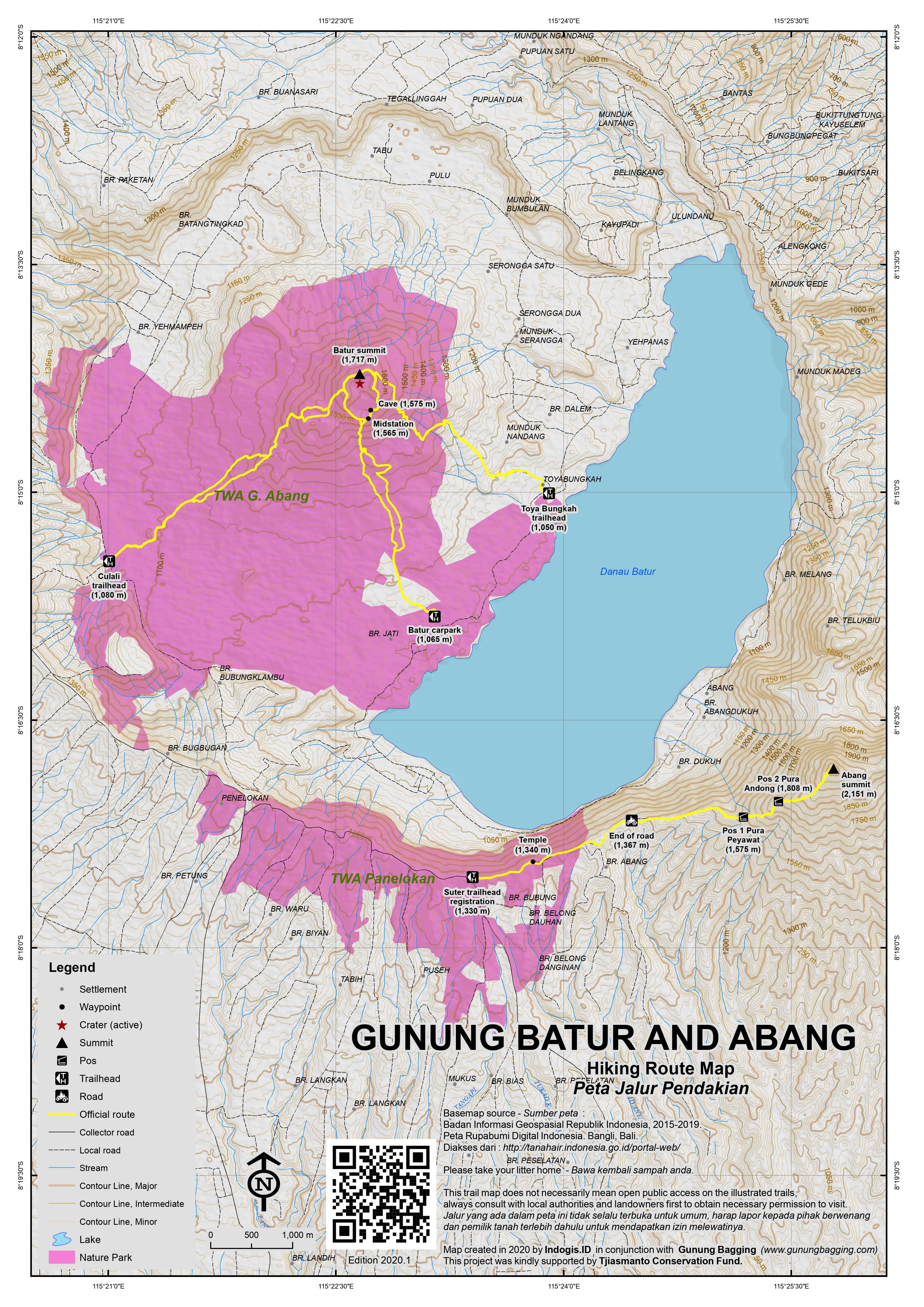
For a high quality PDF version of this and other trail maps, please download from our Trail Maps page.
Practicalities
- Getting there: For domestic flights to Bali, for example from Jakarta, we recommend Baolau. It is a very popular destination and all drivers in Bali will know the route. There is apparently a DAMRI minibus connecting Bangli with Kintamani but using public transport could take quite some time and be unreliable.
- Guides and GPS Tracks: Want a PDF version for your phone? Looking for a guide? Need GPS tracks and waypoints? Gunung Batur information pack can be downloaded here.
- Trip planning assistance: Would you like Gunung Bagging to personally help you in arranging your whole trip? Please contact us here.
- Permits: There is a small hut at the main entrance where you arrange a guide if you haven’t already done so. In 2018, entrance tickets cost apparently Rp100,000 if you are a foreigner. Guides Rp400,000.
- Water sources: There is an overpriced shop selling snacks and water but it is better to take your own.
- Accommodation: Try the Booking.com map above or use this link to search for suitable hotels, homestays, resorts and apartments for your trip.
- We recommend Safety Wing as travel insurance for overseas travellers and tourists hiking up to elevations not exceeding 4500 metres.
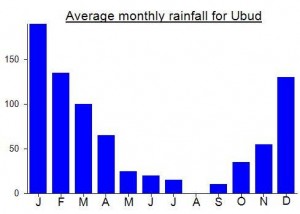
Local Average Monthly Rainfall (mm):
Location
Click on the blue arrow ![]() (top right) to see your current location on the map
(top right) to see your current location on the map
Just got back from Abang and I have to say its an awesome mountain! I was staying with my wife in Ubud so I left the guesthouse at 4am and rode to the start of the hike. The ride in the early morning is very fast as there is absolutely no traffic and the trip took me just 45 minutes to get to the start.
It had been very windy and a heap of trees had blown across the road blocking cars but allowing just enough space for a motorbike to sneak under. When I arrived at the parking area there wasn’t a soul around and I started hiking at 450am. The path is very nice and wide and its impossible to get lost on. At the start I did see a baby snake on the path and almost trod on it so make sure you have a good head torch. I had read that people don’t hike this mountain in the night because of the snakes and I can see why.
The first part is quite flat with the last part jacking up to between 30-35% gradient. There were some really nice views through the trees to Agung. I reached the summit in 1 hour 10 mins. There is a small trail on the other side past the temple where you can get great views of Agung (on the true summit you can’t see Agung).
I stayed on the top for 15 mins before heading down. I was back at the bike 30 minutes later making the entire trip under 2 hours. As I was riding out there is a small Balinese hut on the left and a guy riding a motorbike wearing a very thick jacket that would look more at home in the Himalaya than Bali yelled out to me. I assume he wanted me to pay but I just kept riding on. It was 6.55am when I passed and I guess before about 7 you should be ok. You could certainly just gas it past as I didn’t see a gate where people could stop you.
I was back in Ubud at 8am and my wife still wasn’t out of bed. Great morning out and I can highly recommend Abang its a great mountain with a very nice trail to the top.
NB: I just read an article in the Bali Tribune that says the Russians are investing 10 million USD for a cable car to run to the summit of Abang. It is going through the processing phase so get to the mountain before it changes forever.
Finally went to the summit of Batur after 8 years of trying. I tried in 2011 and 2015 from the popular tourist side on the east. I went along with my friend and we were both pushed and shoved by mafia that run the place. This time was much better and I have been missing out for all these years.
I poured over Google satellite images for about an hour trying to see the best way up. I found a route from the south-west that looked doable so off I went at 330am from Ubud. I got to the start at 445am and started my hike. At first I really had no idea where to go because the cloud was so thick I couldn’t see 20m in front but I just followed the Google satellite images and carried on. There is an active crater that is really cool. I’m not sure if it is sulfur that is being emitted because I couldn’t smell it but the rocks were very hot so maybe it was just heat coming off. I tried to go to the right side of the crater but had to turn around because the way was just way too steep and coming down was a little sketchy.
I went the other way, to the left and there is a great path from here all the way to the summit. The path is huge and well worn so I’m guessing it was a very popular path that doesn’t get used anymore? Who knows but there was no one on the trail and it was amazing to have the whole place to myself, even though I could see 20m because of the cloud.
I’m going to leave the path a secret because it’s so awesome and the longer the mafia stay away from it the better. I have no idea why it doesn’t get used because on the maps it looks much shorter than the 2 other popular routes. Really cool adventure trip and I will certainly be back to Batur again to hopefully see the sunrise and not just thick cloud.
This sounds like the Culali trail which is growing in popularity among local hikers who understandably want to avoid the ‘mafia’! If you have a GPX file for it please send it over for the next edition of our trail map! Cheers, Dan.
Finally made it up Gunung Abang last weekend after it lurking on my list for several years. Had planned a weekend trip late last year, but after Agung’s eruptions I decided to cancel as there seemed to be a serious chance of the airport being closed and me not making in back in time for work on Monday morning. It’s still erupting fairly frequently now, but given that the airport has only closed once or twice for a few hours recently I thought I would risk it. Nearly didn’t get to CGK in time after being stuck behind a huge truck with a MAERSK shipping container going down a narrow, winding kampung road on the way there. Mayhem. What were they thinking?
At the other end, Denpasar airport has undergone massive renovations and development and is still undergoing some more in the car park area. This means at present it is absolute chaos when you walk out of the terminal and try to find a Grab or similar. The usual pests following you around trying to push you into an over-priced ride, and Grab riders cancelling your orders because they know they will face intimidation from regular taxi drivers or the thugs who hang around the airport making money out of the overcharging.
I decided to walk out rather than give my money to one of these ruffians, but in the dark with no proper signage it was not easy. Must have been almost a kilometre of working my way round a building site and through numerous different car-park zones. Finally neared the exit to find I was the wrong side of a high, prison-esque perimeter fence with no way over or round! The Grab bike drivers were on the other side! Had to walk even further and then back round. Ridiculous situation, and one which the airport management really need to resolve as a matter of urgency. What a mess.
Sadly, this issue clouded the weekend, and probably clouds the trips to Bali of many folk, especially if you are on your own and do not want or cannot afford to hire a car and driver for the day, or if you can speak Indonesian and are used to reasonable prices rather than the tourist prices which have so negatively impacted so many people’s experiences of this island. If so many regular drivers and ojeks were not so greedy in the first place then Grab and the like would not be a problem for them, but it seems many in Bali won’t get out of bed for less than Rp200,000, and feel shameful if they give a foreigner a decent price rather than milk them for all they can. They will never see most foreign tourists ever again, so why not? Get whatever you can. At the moment you can get a Grab into certain areas, but in those areas (a large number if not all beaches, tourist areas, smaller neighbourhoods) you will find signs saying ‘online taxi drop only’ meaning if you want to get out again you have to negotiate with a local driver, who will most likely try to rip you off.
The public transport in Bali is almost non-existent and in any case the bus terminals are crawling with guys whose sole aim is to extract as much money from the wallets of foreigners, so I ojeked my way up to Kintamani. Ordered a Grab bike in Mengwi – he arrived, a friendly student, then a local thug rode over to tell him online ojeks are not allowed so he would have to cancel the order. I had to then negotiate with the thug.
The temperature is just perfect up at Kintamani, and the panorama over the lake and Gunung Batur as soon as you reach the outer caldera rim near the restaurants is just brilliant. The peak of Abang was poking out above the clouds. I tried to find a local ojek for the following morning at 5am. Only a 15-minute ride from the lake accommodation to the Abang registration post, but once again they all seemed unwilling to want to do any work at a reasonable price. One guy wouldn’t settle for less than Rp200,000. For a 15 minute motorbike ride. Ridiculous, though the people of this region do have a particular reputation.
One chap was trying to sell art on the street, which I had no interest in, but as he had clearly sold so little he was also interested in being my ojek driver the next morning. He told me he would help me if I bought one of his pictures. No thanks. Finally got him down to Rp80,000, still quite expensive really, but better than trying to find an ojek at 5am. Back at the hotel a group of noisy bikers arrived, turning the tranquil atmosphere into a motorbike garage, with seemingly no awareness that people might not want to listen to them revving loud engines right next to the restaurant. Damn pests!
And at 2.30am, half the hotel was alive with people having coffee and being picked up to go sunrise trekking on nearby Gunung Batur. So I would not recommend staying in Kintamani if you want to get a proper sleep! Mr Art Ojek Man was there by 5am and we set off back up to the outer caldera rim and then to the left along the road which follows the forested rim. Got off at the registration post at a road junction. Nobody was there but in the book a few Indonesian names for the same morning, who perhaps hiked up for sunrise. I might have done the same, but being alone I though it better to wait until just before first light so as not to get lost.
From the registration post it is actually more than 1km along a tarmac road to the actually starting point. In the dark, in low cloud, alone, this was rather eerie. There are a number of minor junctions, but if you stay to the left (the edge of the rim) then you should be fine, other than having to skirt round a temple. It took me about 20 or 25 minutes to reach the proper trailhead from the registration post. There were a couple of tents on the edge of the rim, a couple of cars, and about ten motorbikes. Once you are on the trail, it is easy to follow – well-defined. Once again, you just need to stay to the left and follow the ridge of the rim as it rises steeper and steeper. Be very careful, as the drop is several hundred near-vertical metres.
At around 0647 local time, I suddenly felt nauseous and at first thought I must have drunk one too many Bintangs the night before. But the feeling continued and the ground shook quite ferociously for 20 seconds or more. I realised it was an earthquake and assumed the tremors must be connected with nearby Agung. I checked my phone, which still had a very good signal, and saw it was from Lombok. 6.4 magnitude. Pretty serious. I continued on.
The views down to Lake Batur is fabulous and at Pos 1 (the first, small collection of temple buildings) the view is spectacular, both ahead to the peak and over to Gunung Batur. Look out for birdlife here… I saw lots, and all quite tame, hopping down the trail ahead of me. There is very little litter, and the forest environment is gorgeous, as the first rays of sunlight cut through the tree branches. Very far from the Batur experiences of hundreds of noisy hikers trudging up in a long line. The small temple at Pos 2 is at a particularly lovely stretch of trail.
The first of two large groups of Indonesian students came down, chatting to me about the earthquake. They had felt a second one too. To the right side of the trail you can see Gunung Agung through the trees – and how immense and beautiful it looks from this perspective. I finally made it to the top (‘Pos 3’) around 2 hours after properly starting at the trailhead, so about 2 and a half leisurely hours in total from the registration post if you are walking from there instead of continuing to the actual trailhead.
2151.2m apparently. Views to Batukaru and as far as Gunung Raung in East Java to the west, and as far as Rinjani in the east. A gorgeous, airy summit. Agung is mostly hidden by trees at the actual summit. If you like solitude, then this is a much, much better choice than Batur or Agung.
Back at the registration post I was asked to pay for an entrance ticket. Rp100,000 for a non-Indonesian vs Rp5,000 for an Indonesian. I showed them my tax card and a few other things and said I was not happy about paying 20 times the rate when I live, work and pay income tax in Indonesia. So, they said Rp20,000 is the price for locals (it isn’t but it’s a lot more reasonable than Rp100,000).
I walked all the way back to Kintamani (an ojek would probably be a better idea as although pleasant the road is quite busy) and had an early lunch before ojeking back down to the Denpasar area and a few beers at Batu Belig beach, Seminyak. Saddened to read updates about the earthquake – several dead and Rinjani closed due to landslides. Back at the airport it was further chaos – any motorbikes heading in there have to use a separate route, which involves crossing over in front of oncoming traffic. Just a total mess, and then another 5 minutes of walking through carparks to get to the actual entrance which is surrounded 24 hours by ‘transport’ guys who no sane person wants to deal with. There may be a lot more restaurants in the airport now, but outside is as bad as it ever was and the authorities urgently need to clean this place up!
Saddened to later read of at least 2 hikers in Lombok (one already hiking and one in accommodation pre-hike) who died in the earthquake. Hundreds still unable to descend due to the trail being blocked by landslides. Staggering video footage slowly being released of the earthquake, filmed by hikers on Rinjani rim. RInjani remains closed and probably will do for several weeks at least. Minor aftershocks continue several days later.
Just back from doing Batur a couple days ago, for the second time (see previous post). Had a wonderful day with beautiful weather. One of the nicer Indo hikes we have done. We bucked the trend and decided on a day-light hike, as opposed to the Indo-tradition of climbing at night to be at the top for sunrise. We left Sanur at about 4 am, and were hiking by 6 am, just in time for sunrise. Lovely time to be hiking. The real bonus is being on a schedule no one else is on, meaning no crowds! We had the trail to ourselves, except for one 10-mins period when the 100 or so people came down all at once from the night hike. We also bucked the trend by not having any pre-arranged tour or guide. We had our driver simply bring us to the parking lot (any driver in Bali will know where this is). Highly recommended! No “agent” and no “tour”.
Once at the parking lot, we simply approached the office of the infamous and dreaded “Association of Mt. Batur Trekking Guides”, which is clearly marked and obvious. Despite the legendary nastiness written about by others, I had a rather pleasant exchange of information which included me telling him (the guy in the office) how many people (4 of us), and him telling me the price: 400K Rp for the guide + 100K pp for the entry fee = 800K total. All in all, not completely unreasonable, so I simply accepted, and there were smiles all around. With that, we packed our water and snacks, and headed out to the sounds of birds and roosters. Beautiful day, fantastic climb to the top, we took the circle route around the top of the crater, and then back to base. We were back in Sanur by 1 pm.
Travel tips: 99% of people do the night/sunrise-hike, so if you do that, you will be hiking up in the dark and congregating at the top with hundreds, if not thousands of people. Leaving the parking lot at sunrise means you hike in daylight and avoid the crowds (we have done Batur both ways, and much preferred the day hike). Arranging a driver from wherever you are staying, and then simply showing up at the Mt. Batur parking lot, and arranging a guide on the spot, is entirely doable, and probably cheaper than arranging the standard “package tour”. We (4 adults) paid 600K Rp for the car/driver + 800K for the hike (total = 1.4 million Rp for 4 people). When you get to the top, if you are feeling good, do the circle trail that follows the crater ridge around Batur, then comes back down the other side to meet the main trail. A much nicer hike, that is mostly level around the crater. Besides, the true peak (which is marked with a sign) is not at the sunrise viewing station, it is mid-way along the crater trail. Bring your own snacks and drinks, and just say “no” if they offer you a “breakfast” (for a ridiculous fee of course), which is 2 hard-boiled eggs, and 2 white pieces of bread. One last tip: do it on a weekday/non-holiday if you have the choice.
Batur was an easy trek. However, it seems that everyone is grouped together on the trek. It is almost like a tourist trap, the only way was to get a guide from the village itself if you wanted to DIY.
Luckily I found a good deal on my trek. You can read up more on: http://www.yonderingsoles.com/2017/08/07/mountbatur/
I did it in combination with Agung the next day on my trip.
Just back from the hike up Gunung Batur. Unfortunately mostly cloudy, so no amazing sunset, but great views all the same. The hike is as described above, and takes about 1.5 hrs from the carpark to the top. The Batur caldera is incredible, and definitely worth experiencing. Once at the top, and thus encountering the chaos of hundreds of people waiting for sunrise, I would recommend going past the warungs, where all the people are congregated. Walk another 50 m, and you will likely have a spot on the ridge to yourself. To return, definitely continue along the ridge walk and do the circuit back to the main descent trail, i.e., the high crater ridge trail does a circle and leads you back to the main trail below, and is thus a circumnavigation of the crater, that takes little extra time. Nice way to come back. Hot tip: bring your own thermos of coffee/tea, and your own breakfast for that matter. The standard “breakfast” the guide will give you is classically bleak (boiled egg + white bread with banana inside; coffee/tea not included). If you want to enjoy a coffee and good snacks at the top (highly recommended), bring your own. Basically ignore the warungs and the associated crowds, and tell your guide you want to go past them. And as has been mentioned, this hike could easily be done without a guide (from the parking area, just follow the stream of people and headlamps), so if you can somehow get around the “obligatory-guide” rip-off, all the better.
Gunung Batur is one of the worst tourist traps in Indonesia. If you approach the mountain guides stop your car (!!) and force you to pay money that is about four times above the normal price you should pay for a tour. The mountain is a ridiculously easy hike. No guide at all should be needed. Ok, if they want to control what happens on the mountain, I can understand it. But I do not understand why they steal so much money from the tourists.
Now, the mountain itself and the area arount it is indeed interesting. If you never have seen a volcano and want to see one you can climb it. If you have gone to other volcanoes, then I dont see much reason to climb Gunung Batur. You can have hundreds of other volcanoes for free that are as interesting as Batur or much better.
Indeed, Matthias. A lot of them are basically highwaymen who think they are owed money by anyone non-Indonesian.
I think this place is a great place to visit for the mountain climber’s.
Climbed Batur a couple of days ago for dawn – very straightforward as the starting point is at about 1,050m meaning less than 700m to climb. The guides seemed pretty pleasant this time though the (over-priced) warung owners are continually looking for customers. The guides talk of three different lengths of hike – short (just to the first warung at 1,550m and back) – medium (a circuit of the rim) – long (a circuit of the rim and an exploration of the crater area). Most people just do the short hike but if you want to reach the highest point make sure you do the circuit. I did the round trip in about 3 and a half hours. The highest point is the narrow section of the rim – past all the warungs (3 or 4 in all) and just above and a little way beyond a spot where guides boil eggs for hikers in natural hot water on the side of the crater cliffs. In additional to the great views of Agung and the forested Abang in the foreground on the opposite side of the lake, there are some suprb views to the Batukaru mountains west of Batur when you get further round the rim itself. I then descended down through lava fields where there seems to be some minor quarrying activity going on and where there is a small temple – apparently much larger before a recent eruption covered the area in black lava rocks. All in all, a fabulous and easy hike. There are tour agents all over Bali who can arrange transport for you but if you’re on your own it could be quite expensive so much better to try to join a trip with others (plenty agents can pick you up at Kuta, Sanur or Ubud at 2am on the way). Expect to pay no more than Rp400,000 each including guide, transport there and back and a couple of eggs and coffee.
I went there last weekend.
You just need around 2 hours to reach the TOP. A great Sunrise also nice track to the top.
Batur is a geological wonderland.A big exposed hole in the earth with a caldera and a strato volcano. Indeed the the guides can be pushy,and they will even try to tack on more guides to your group as your push torwards the summit. A quick summit with ethereal views of the Kintamani lake, marslike landscape with lush green hues contrasting the jagged black volcanic rock.Great place to catch a sunrise and see Agung and Rinjani under a purple and orange Balinese sun.