
Facts
- Elevation: 1,324 m (4,344 ft)
- Prominence: 1,090 m
- Ribu category:
 Kurang Tinggi
 - Region:
 Peninsular Malaysia
 - Malaysian state: Perak
- Coordinates: 5.0833, 101.0975
- Rating:
 (Bagged it? Be the first to rate it)
 Loading...
 - World Ribus ID: 68660
Bagging It!
Gunung Ulu Soh is not a popular mountain, with just two groups known to have hiked it in recent years. One of those was in 2024. A 4WD is needed, and that is not cheap so you will need a group keen on doing the hike. It sounds like it ought to be possible as a dayhike, but only if you start at first light.
Practicalities
-
- Getting there: For Malaysian domestic flights and flights within Southeast Asia, for example to Kuala Lumpur, we recommend Baolau. Penang is the nearest large airport. Sungai Siput is the closest train station.
- Permits: You can register and pay for an e-Permit online from the Forestry Department of Malaysia website.
- Water sources: Unknown
- We recommend Safety Wing as travel insurance for overseas travellers and tourists hiking up to elevations not exceeding 4500 metres.
Local Average Monthly Rainfall 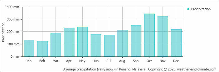
Location
Click on the blue arrow ![]() (top right) to see your current location on the map
(top right) to see your current location on the map
When my Ulu Sepat trip fell through due to a lack of participants, my Plan B was Ulu Soh, especially after hearing that another group had hiked it in 2024. Unfortunately, it seemed very challenging to find an affordable 4WD driver and guide at short notice.
The obvious meeting point for this is the OAOSC (Orang Asli One Stop Centre) in Bawong near Lasah. This area is best known for Bukit Berekeh, a short hill walk above Bawong to a grassy ridge and viewpoint, around 400m high.
From Bawong to Ulu Soh would be a fair distance by 4WD, as there are tracks quite high up the hillside to the east of the peak. In good weather I am sure this would be doable as a dayhike, but very few people know the way and it is not a popular trek by any means. Not yet, anyway!