
Facts
- Elevation: 1,038 m (3,406 ft)
- Prominence: 1,038 m
- Ribu category:
 Kurang Tinggi
 - Province:
 Maluku (Moluccas)
 - Island: Ambon
- Coordinates: -3.5457, 128.2558
- Rating:

 (12 votes) Add your rating
 Loading...
 - Other names: the highest peak in the range is Simalopu
- World Ribus ID: 69200
Photos
")
")
")
")
")
")
")
")
")
")
")
")
")
")
")
")
")
")
")
")
Bagging It!
The Salahutu mountains are the highest peaks of Ambon island, with two over 1000 metres high. Although that does not sound particularly high, the hike is rather challenging for a mountain of such a size and the highest peak has only recently been started to be regularly visited. Salahutu is the name of the second highest peak in addition to be the name of the range as a whole. Lots of local students climb Salahutu peak (1,004 m) from Waai village (famous for its belut – sacred eels) but they usually do not include Simalopu peak, which is the highest (1,038 m), as this requires at least one night camping. They can be combined, but are often hiked separately to save time rather than the more lengthy traverse of the range which also visits a third peak called Salamoni (995 m) which lies between the two higher peaks.
Hiking Route to Puncak Simalopu via Tulehu (Ewang) by Laurenz Thiele (March 2025)
The hike begins at a chicken farm, locally known as Kandang Ayam. This is the best place to park a vehicle before setting off on foot. From the parking area, follow the local road uphill for about five minutes until reaching a crossroad. Here, the official trail begins. To the left of this junction stands an abandoned house, marking the transition from the road to the wilderness.
Continuing along the trail for roughly an hour, the route leads to Pos Bukit Kasauri (310m). This area features a small cliff, a remnant of a past landslide. From Bukit Kasauri, the trail continues for another 30 minutes, leading to Pos Air Pertama (328m). This resting spot features a small shelter and a freshwater stream, making it a good place to refill water supplies.
After about an hour of hiking, Pos Air Kedua (564m) is reached. This location is notable for its small waterfall. Just a couple of minutes further along the trail, Pos Air Ketiga can be found (576m). From Pos Air Ketiga, a steep 10-minute ascent leads to Kayu Malintang. This spot offers breathtaking panoramic views and is particularly renowned for its spectacular sunsets.
Five minutes beyond Kayu Malintang lies Ala Ala Buto, also called Ewang (648m). This is a spacious campsite, providing ample room for setting up tents and resting before tackling the more challenging sections ahead. Beyond Ewang, the trail becomes denser and harder to navigate. The route ascends along the side of the ridge, following a narrow and occasionally treacherous path. After an hour of climbing, Puncak Sipil (839m) is reached.
From Puncak Sipil, the trail descends steeply for about 15 minutes to reach Pos Air Makan Babi (806m). This location has no significant landmarks but serves as an important navigation point.
The final ascent begins from Pos Air Makan Babi, following a narrow path along the side of the ridge. This section is challenging due to a landslide area. After an hour of climbing, the summit ridge is reached, where the landscape transitions to dense bushes with no large trees. The first summit, Puncak Simalopu Radio, also known as Puncak Simalopu 2, just a few metres lower than Simalopu itself. However, this area is closed and does not offer a clear view. A final descent followed by a short ascent of ten minutes leads to the true peak of Ambon, Puncak Simalopu. This marks the highest point of the hike and offers a rewarding conclusion to the journey.
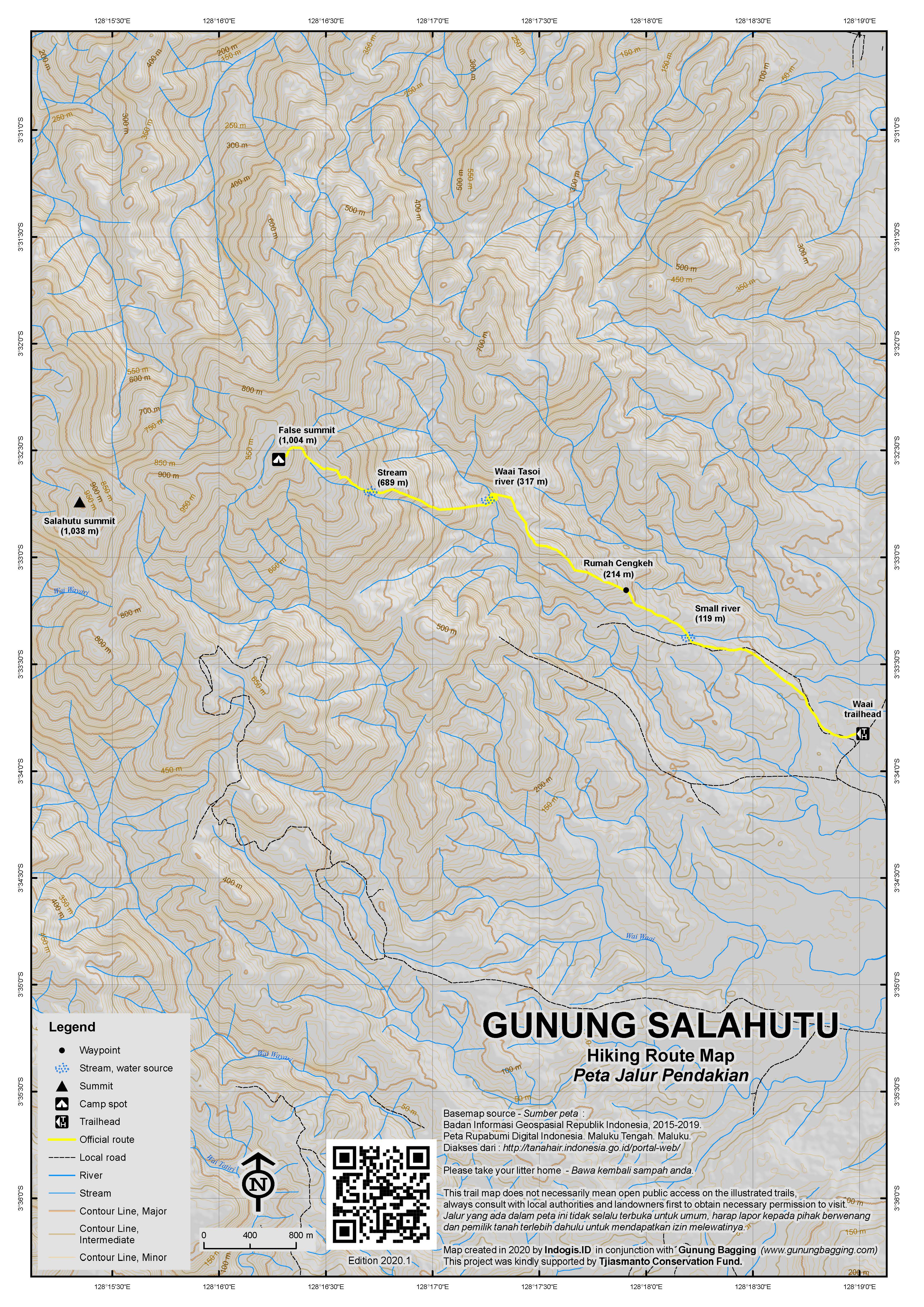
Hiking Route to Puncak Salahutu via Waai
The more popular hike to Salahutu peak is a very worthwhile hike in itself with extensive views over the east coast of Ambon island and some minor peaks of western Seram in the distance. It takes about 5 hours to reach the summit from Waai village on the Leihitu peninsula and the trail starts just a few metres above sea level.
From the brow of a very minor hill on the main road near Waai a small plantation trail leads up into the mountains. Finding it could be tricky without a guide as there is no sign and you could easily drive past it. Follow the trail as it weaves through plantations. At an approximate elevation of 140m there is a junction where you take a right turn which drops down to a small stream and then up to the remains of a building called Rumah Cengkeh (‘Clove House’, 214m). The trail then begins to climb up onto a narrow spur with steep drops either side. This is already a fine viewpoint although if you want to avoid the worst of the heat it is probably a good idea to climb at night. Indeed, progress is very slow and even when you eventually reach the grand elevation of 450m, you find that the trail descends steeply down to the left to the Waai Tasoi river (317m). This is a good place to have a rest before crossing the river and ascending once again. There are some beautiful and large butterflies in this area, both during the day and at night.
After heavy rain the river may be difficult to cross, but even during the dry season you may very well have to take off your shoes and socks and wade across so be prepared! The trail now ascends steeply and is muddy and covered is thick roots which can make things a bit difficult. However, once above 500 metres elevation the temperature gets a little lower and you start to sweat less! The sound of the river still reverberates long after leaving it and when you reach a sign at 689m the trail is very close to another smaller river. This is the final source of water on the hike.
From this point the trail gets muddier but the view really opens out and eventually you will reach the top of Salahutu, the second-highest peak in the range. It is crowned with a broken cement trig pillar and the remains of a few small camp fires. The view eastwards is not limited by trees or other vegetation and as a result you can see the eastern coastline of Ambon island, nearby Haruku island and some of the lesser peaks on the large island of Seram.
The view west is largely obscured by trees but if you look carefully you will be able to see the true high point of Ambon island, lying about 2 kilometres further west, beyond a lesser middle summit, Salamoni, inbetween. The highest peak is Gunung Simalopu, a much less frequently hiked mountain that until recently was somewhat unknown. Back in 2010, there was simply no information available. Thankfully, by 2025, things have changed recently and it is now possible to hike Gunung Simalopu, though this requires more time. It can be accomplished from Tulehu (see above), Waai and from the north at Hanenu (Morela). If continuing from Puncak Salahutu to Salamoni, allow 1.5 to 2 hours and enjoy some good views on the way possibly including the Ambon Bridge in the distance. Allow at least another 2 hours from Salamoni to Simalopu.
If returning rather than continuing on, the descent from Salahutu peak takes about 3 and a half hours. Local hikers like to bathe in the Waai Tosoi river on the way down – a good way to cool off before the final 90 minutes through plantation back to the main road.
If you stay in Ambon city, it is worth taking an ojek (motorcycle taxi) up into the hills behind the city to Soya Atas (5km away) and make the short 10 minute climb to Gunung Sirimau (464m). It is a historically important areas and is full of sacred stones and the like. There are some nice views over the city and to the highest peak in the distance.
Bagging information by Daniel Quinn (with significant updates in March 2025 from Laurenz Thiele)
Hiking Route to Puncak Simalopu via Hanenu (Morela) by Laurenz Thiele (2025)
The hiking route starts in the north near to the coast at a farmer’s shelter in Hanenu near the village of Morela. This route is more often used for descents but is perfectly fine as an ascent route. The trail passes through a pala (nutmeg) plantation and quickly begins a steep uphill climb. As you gain elevation, stunning views open up along the narrow ridge, with sharp ridge lines visible on either side. You’ll also pass through a cengkeh (clove) plantation before entering denser forest.
Roughly halfway to Waai Ima, a reliable unnamed stream (370m) offers a quick water refill opportunity. After around 4 hours, hikers reach the Waai Ima River (639m). The clear water and flat banks make this an ideal spot for a lunch break or rest stop. Continuing for another 3 hours, the trail reaches Batu Tungku (927m), a unique rock formation. The area offers a wide, flat space suitable for camping and has easy access to water, making it a popular overnight stop for trekkers.
From Batu Tungku, it’s a final 30-minute ascent to the summit of Puncak Simalopu, the highest point of the trail. While there may not be sweeping views due to dense vegetation, the feeling of isolation and accomplishment makes it a memorable peak to conquer.
Trail Map
For a high quality PDF version of this and other trail maps, please download from our Trail Maps page.
Practicalities
- Getting there: Plenty of flights to Ambon from across Indonesia. From Ambon city, take a taxi or ojek for the approx. 25km to your chosen starting point – this should take no more than one hour.
- Guides and GPS Tracks: Want a PDF version for your phone? Looking for a guide? Need GPS tracks and waypoints? Gunung Salahutu information pack can be downloaded here.
- Permits: Not required but take a photocopy of your passport photo page just incase.
- Water sources: Thankfully there are several on the Salahutu peak route. A stream at 119m, the Waai Tasio river at 317m and the river below the sign at 689m. For Simalopu, Air Pertama, Kedua and Ketiga are the water sources on the trail from Tulehu.
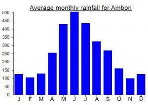
Local Average Monthly Rainfall (mm):
Location
Click on the blue arrow ![]() (top right) to see your current location on the map
(top right) to see your current location on the map
tidak ada puncak palsu dan puncak asli, ketiganya memiliki puncak masing”, kalau mau ke salahutu itu sudah benar puncak salhutu, kalau mau ke titik tertinggi pulau ambon ya namanya simalopu, ketiganya berbeda bukan palsu atau asli
Harus dibedakan antara istilah topografi dan istilah pendakian:
Secara topografi, dikenal Pegunungan Salahutu dengan tiga puncak yaitu Simalopu, Salamoni, dan Salahutu.
Dalam istilah pendakian, puncak tertinggi atau puncak asli adalah Simalopu, sedangkan Salahutu termasuk kategori false peak atau puncak palsu, karena saat mendaki terlihat seperti puncak utama, padahal bukan yang tertinggi ..
I’d like to clear up some confusion, as there doesn’t seem to be a definitive answer in this forum.
The false summit is known as Gn. Salahutu, while the true summit is called Gn. Simalopu. Between these two peaks, there is another one named Gn. Salamoni.
Gn. Simalopu, the actual highest point, is quite isolated, which is why most people climb the more accessible false summit, Gn. Salahutu. However, there are three trails leading to the true summit—one from Tulehu, one from Waai, and one from Morela.
Many locals aren’t aware of these routes because they are not public trails. However, as a member of an outdoor community in Ambon that regularly uses these routes, I can confirm they are navigable. If you’re interested in climbing to the true summit, feel free to reach out!
You can contact me via WhatsApp at +32468214522
This great write up is still mostly applicable as of February 2025. I did the 2:00 am start for the sunrise hike, and I joined a fair number of local university students either hiking or camping. My guide took us to the popular fake summit, but I was ok with that. The Hutan Lumut at the top means the whole mountain is super muddy and covered in tricky roots, but it was a fun hike especially in the dark.
This just in from Wolfgang…
“Unfortunately, my guide led me to the same false peak where you have been before. It is the center of my pics, taken from the south. The real pic is left/west of it. It may be easier to reach the real peak in the future as a dust road has been cut through the vegetation south of Salahatu, parallel to the range. It starts in Waai village at the eastern coast and is appropriate for motorbikes. As my guide promised to me that he will lead to the real peak I trusted him and we left this dust road too early to the right/north, following the traditional trail that you have described. Hence I suggest to stay as long on the dust road as possible and only then turn right/north or northwest. As the jungle is not dense even hacking through might not be impossible should there really not exist a trail. My guide came from the city of Ambon, so recruiting locals in Waai might be more wise.”
Just back from my failed attempt on this one… an unexpectedly tough one. Nobody I met seems to know much about the true peak, only the second highest peak that is a popular climb for locals. Great dawn views but utterly knackering. I climbed at night and in rain (which cleared by morning) but I have never climbed so slowly due to the humidity and temperature. A pretty mental trip to do on a regular weekend but better than sitting around Jakarta with the usual oceanic quantities of Bir Bintang for company. I hope to find out about the true peak before long.