Facts
- Elevation: 1,959 m (6,427 ft)
- Prominence: 380 m
- Ribu category: Spesial
- Province: Jawa Barat (West Java)
- Google Earth: kml
- Rating:
- Other names: none.
Photos
Bagging It!
Rakutak is one of the lesser-known mountains in the Bandung area yet it offers excellent views across the region and is one of the nicest ridge walks in Java. It can easily be done as a day trip from Bandung, requiring just over 3 hours to ascend and 2 hours to descend. The mountain looks remarkably impressive once on the Pacet road south of Ciparay which runs between Gunung Rakutak (east, left) and Gunung Malabar (west, right).
Since 2016, Rakutak is part of Cagar Alam Kamojang (Kawah Kamojang Nature Reserve) and access for hikers is more complex. Technically, the summit ridge of the mountain is closed off to hikers and indeed anyone except those conducting scientific research or similar.
You can try to obtain permission to visit but it may not be granted. You are, however, still more than welcome to enjoy the atmosphere where the trailhead traditionally began in the friendly village of Sukarame (966m) just beyond the town of Pacet and at least take some photos of the mountain even if you can’t get permission to hike it.
Should the situation change and responsible access be allowed, the below information from a 2012 trip with minor updates may be still relevant:
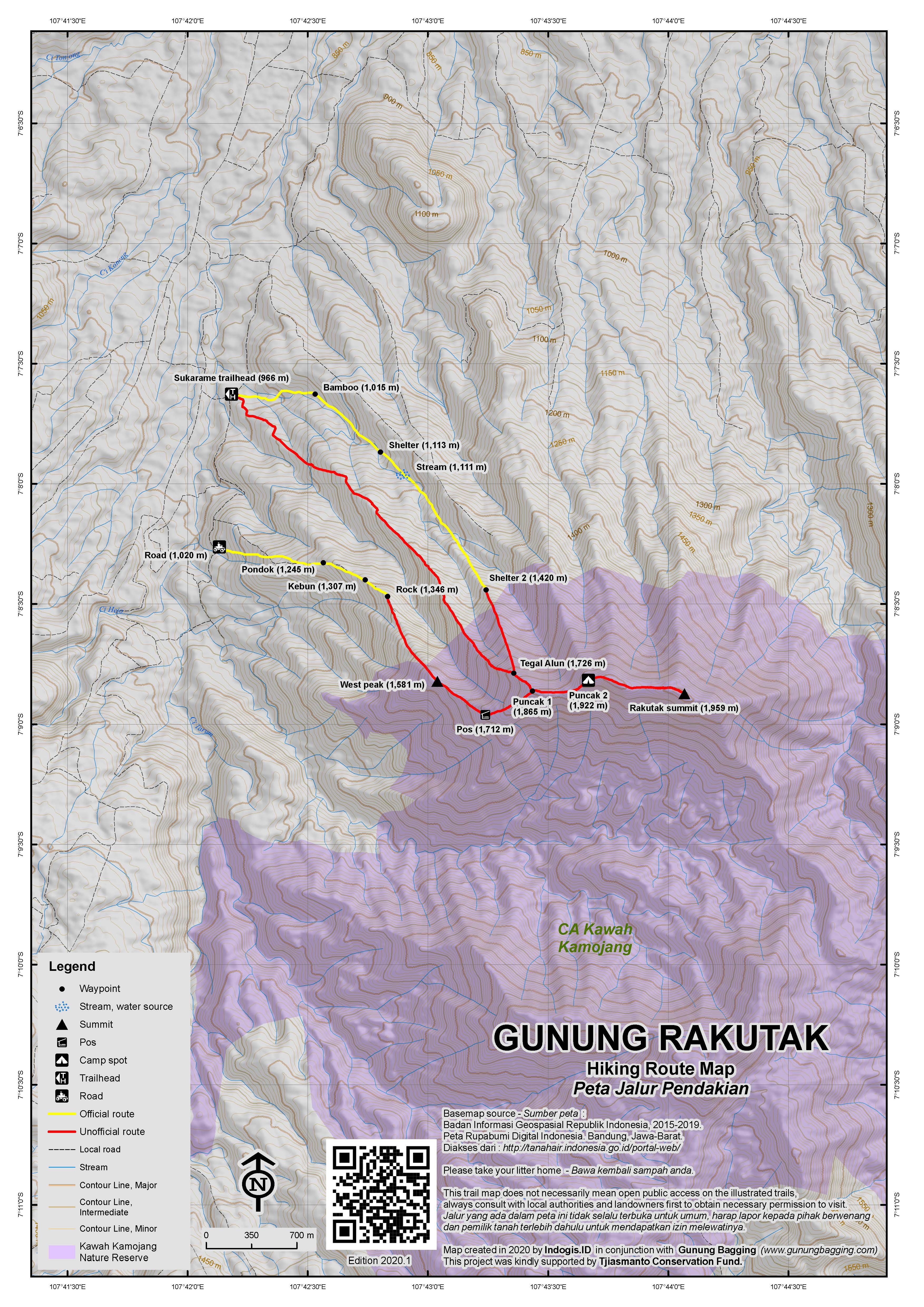
“Motorbikes can be left at the warung (village shop) especially if you buy some water and snacks there and this is the ideal start as the trail begins opposite the shop. There are three separate routes up, two of which begin in the village and one which begins about one kilometre further south. Two are ridge trails and the third which is the most popular and the easternmost follows a stream (the only water source on any of the potential routes up and dry during the dry season) before ascending a ridge.
A guide is essential as the beginning section of the most popular trail leads up slippery cement paths in the village before traversing farm fields and then entering the shade of bamboo (1,015m). The trail follows and criss-crosses a stream which is dry during the summer months but definitely expect a trickle during the rainy season. A shelter is on the right at around 1,113m and the final place for water during the rainy season is at 1,111m as the path crosses the stream once more. The following section offers a view glimpses of the mountains north of Bandung – Burangrang, Tangkuban Parahu and Bukittunggul.
From this point the trail gets a little tougher and less well-defined as it enters longer grass and bush, some of which may need clearing. Given that not many hikers come here except local enthusiasts from Bandung there is almost no litter to be seen amongst the scattered pine trees. At around 1,420m is another shelter after which the trail enter proper forest and is very clear once more. Tegla Alun (1,726m) is soon reached and this is where the easternmost trail meets the middle trail coming up a different ridge.
After less than an hour in the forest in total is Puncak 1 (1,865m) which is where the third trail (the westernmost) meets from the west. Here the panorama is superb. To the north is Bandung and the hills to the north of the city. To the west is the large, wild massif of Malabar. To the south is Gunung Kendang, Papandayan, Cikuray and Wayang-Windu. To the east is the narrow ridge which leads for a further kilometre to two further tops, the final one of which is the highest. Beyond the Rakutak ridge itself is the higher Guntur mountain range.
To the southeast you should be able to see a small lake nestled in the col between Rakutak ridge and a smaller ridge to the south. This is Situ Ciharus (approx 1,530m) and for those wishing to make a full weekend of their hike this lake would be a great extension to the regular dayhike although it is now closed to the public. Note that this lake may be known as Danau Pangkalan on certain maps. In the past it used to be possible to do a traverse of the mountain.
From Puncak 1, the narrow ridges drops down slightly before leading up to a second peak (Puncak 2, at a height of 1,922m) which is the best for camping due to its relative flatness and size. You may be able to fit 3 or 4 tents here. Once again the ridge continues eastwards through some slightly denser forest and an allegedly windy camping spot before rising to the highest point at around 1,959m. This is the summit and is known to some hiking enthusiasts as Puncak 3. Our guide told us an interesting story about how, towards the end of the colonial era, local republicans climbed up Rakutak to escape from Dutch troops who then shelled it in an attempt to kill them.
You may see monkeys thrashing around on the lower slopes of the mountain and, as with many peaks in Indonesia, there is plenty of visible evidence of wild pigs (‘babi hutan’) though they are very rarely spotted. From the summit it takes about 30 minutes to get back to Puncak 1, at which point you must choose between retracing your steps the way that you came or taking the left turn down the slightly more westerly ridge. The latter is recommended as it is equally well-defined as the other trail and goes via a Pos (1,712m) then an outlying western peak (1,581m) where you can sit for a while and enjoy the panorama to the fields in the valley between Rakutak and Malabar, plus the great flat plains of Bandung further north.
Further down the ridge towards the village is a huge rock (1,346m) which is ideal for sitting on before descending through the fields and veering towards the right (north) back to Sukarame.
Bagging information by Dan Quinn, November 2012.
Nominated as a Spesial by Jang Yudi.
Trail Map

For a high quality PDF version of this and other trail maps, please download from our Trail Maps page.
Local Accommodation
Practicalities
- Getting there: For domestic flights from or to West Java, such as the airport in Bandung, we recommend Baolau. It is just over 30km from Bandung to the starting point at Kampung Sukarame and the journey can be made by taking a Majalaya-bound bus from Bandung and alighting at Ciparay for an angkot. Take a right turn for Pacet at the often-busy Ciparay market. Once beyond Pacet look for a small road on the left with an orange entrance gate. The village of Sukarame is just two minutes along this road which goes over a river. The journey from Bandung to Sukarame takes 2 hours or significantly less if you go by motorbike at times when there isn’t too much congestion on the roads.
- Guides and GPS Tracks: Want a PDF version for your phone? Looking for a guide? Need GPS tracks and waypoints? Gunung Rakutak information pack can be downloaded here.
- Trip planning assistance: Would you like Gunung Bagging to personally help you in arranging your whole trip? Please contact us here.
- Permits: Since 2016, Rakutak is part of Cagar Alam Kamojang (Kawah Kamojang Nature Reserve) so access to the summit ridge may be more complicated and must be sought from the relevant authorities in advance. It very well may not be granted.
- Water sources: Only available during the rainy season at the stream near the start of the easternmost trail from Sukarame. The small lake of Situ Ciharus is an obvious water source but lies a considerable way from the highest ridges of the mountain and is now closed to the public.
- Accommodation: Try the Booking.com map above or use this link to search for suitable hotels, homestays, resorts and apartments for your trip.
- We recommend Safety Wing as travel insurance for overseas travellers and tourists hiking up to elevations not exceeding 4500 metres.
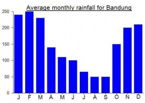
Local Average Monthly Rainfall (mm):


 (10 votes) Add your rating
nice to hear that rakutak is really neat, definitely will be next hiking destination!
As Dan says, it really was an excellent little mountain, and the lack of litter was refreshing.
I’d like to go back and explore the surrounding ridges and valleys at some point – the deep forested valley to the south of the summit looked tantalising…
Myself and writer Tim Hannigan had an excellent hike up Rakutak on Friday morning. Many thanks to Jang Yudi of Jelajah Gunung Bandung who introduced us to local traditional music student and hiking enthusiast Pepep who, along with his mates, took us from Bandung and up the mountain itself.
There had been rain the previous night so the early morning was exceptionally clear – impressive views from the lower slopes across the Bandung plain to Bukittunggul and the flat-topped Tangkuban Parahu.
It actually would have been nice to have spent more time at the top – perhaps camping for one night – for the views of the city lights of Bandung and the panorama of this region of West Java.
Undoubtedly one of the best day hikes from Bandung, and a trail with almost no litter on it.
gunung yang cukup menantang…apalagi jalan setapak yg menuju puncaknya juara :))..suaru hari pasti ksana lagi :))
kok gak ada infonya.? padahal ini gunung menantang,