
Facts
- Elevation: 630 m (2,067 ft)
- Prominence: 630 m
- Peak category:
 Spesial
 - Province:
 Nanggroe Aceh Darussalam
 - Coordinates: 5.8126, 95.2817
- Rating:

 (3 votes) Add your rating
 Loading...
 - Other names: The adjacent Gunung Sarong Kris is much better known.
Photos


Bagging It!
Weh island, also known simply as Sabang (the main town), is a small volcanic island to the northwest of Sumatra. It is a wildlife protection area and is attracting more and more visitors – especially foreigners who come for the snorkelling and incredibly relaxed atmosphere. On the edge of the Andaman Sea it is the beginning or end of Indonesia, and is famous for its Kilometer Nol monument (Kilometre Zero) and is immortalised in the nationalist song “From Sabang to Merauke”. A hike to the highest point remains a tough proposition and is rarely done, but perhaps this will change in time.
Before describing the mountain itself, it is worth looking briefly at the issues that currently deter many tourists from visiting this region – issues that are important to consider when making holiday decisions ethically. Weh is in Aceh province, and this means the legal system is based on Sharia Law. Recently, all female Muslim flight attendants were pressured by local authorities to wear the hijab/jilbab if landing in Banda Aceh. Air Asia’s response was to have only male cabin crew for their flights into the city. It remains a grey area as to whether or not the laws in Banda Aceh apply to foreign tourists visiting for a few days but it is sensible to err on the side of caution here. Ultimately most people here are in favour of Sharia Law, yet the authorities are aware that just one or two international news articles about extending this to tourists from overseas would be highly damaging to a major part of their economy.
Despite the province of Aceh imposing Sharia Law on all of its inhabitants (including non-Muslims), Pulau Weh is a little different to mainland Aceh, relying incredibly heavily on tourism and therefore willing to allow non-Muslim tourists a bit of flexibility when it comes to adhering to the strict rules of the mainland, especially if it is done discreetly. For example, based on informal local agreements, it is possible for non-Muslim tourists to buy alcoholic drinks in one or two places as long as there is no public drunkenness and the drinking is done in private (similar to the situation in Brunei).
That said, there was a very unpleasant incident in Sabang reported in 2015 about a local mob causing trouble when a mixture of local and foreign tourists were celebrating New Year. Nothing major has been reported since but even on Weh the local views are very conservative and given the very different outlooks on life being in such close proximity it probably wouldn’t take a lot for more unpleasantness of this sort to occur. It is clear that if this situation changes for the worse in the future then many people will lose their livelihoods and it is, of course, all about money when it comes to tolerating those with differing views. At present, the balance seems about right, as more tourism would likely lead to a higher chance of problems, not to mention detract from what is a very laidback, quiet atmosphere.
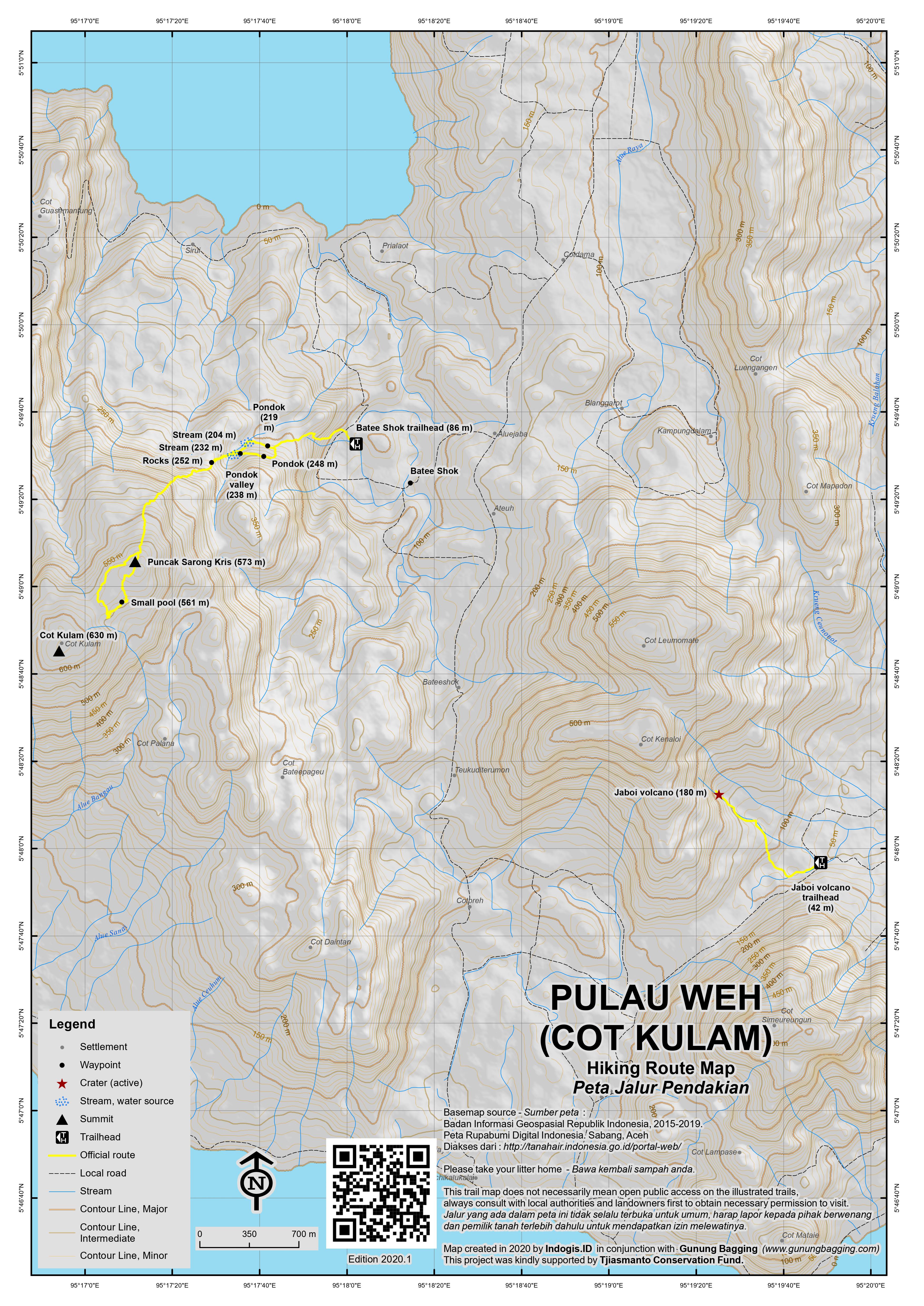
The island has many densely-forested hills, with the main two highest ranges running roughly north-south across the middle part of the island. The ridge to the east has a highpoint of 583/584m, but the main attraction of this range is ‘Jaboi volcano’ or even simply known as ‘Gunung Merapi’ (180m). It is a large active crater with numerous sulphur holes just 200 metres from the main road to the east of the range. It is free to enter and is a wonderful place to take photographs. You can even see the coastline from the top of the crater area at the edge of the burnt trees.
The other high range of hills is a few kilometres further west and includes the excellently-named Gunung Sarong Kris/Keris or “Dagger-Sheath Mountain” (at 573m the third-highest of Weh’s peaks) and Cot Kulam (“Pool Hill”) the highest of all at somewhere around 630m. This is rarely-visited terrain with dense, often pathless forest, and finding a local guide who knows the area is not that easy either (at the time of writing). It does not appear to be volcanically active and offers very little in the way of views to the coast.
The best starting point is probably the village of Batee Shok (about 88m above sea level) to the east of the range. Locals will probably try to dissuade you from hiking up there, or say that no guides are available, and tell tales of buried treasure and a Dutch or Japanese fortress at the top of the mountain which requires a key the size of a man’s forearm to open the entrance door! If you persist, you should get lucky and find a local or two who can do their best to help you to the summit of Cot Kulam. Bear in mind, however, that nobody here knows the name Cot Kulam (despite it being on all the maps) and a mention of Gunung Sarong Kris might be more useful. The way to Cot Kulam from this side goes via Gunung Sarong Kris anyway.
From the mosque and warung at Batee Shok, take a side road running up towards the lower slopes of the range. After a few hundred metres is a small entrance on the left of the road, with a path that leads up the open hillside and zigzags up onto a minor ridge (200m). There are some nice views here over the the Jaboi volcano range to the east. Enjoy the views here as there are very few higher up!
Head straight over the ridge and, depending on your guide, either take a left through overgrown scrub to the remains of a building with planks of wood and a small pool of water and then down a little way to a valley with a large wooden shelter near a stream (approximately 238m) or simply straight on to the wooden shelter and stream (easier). This is the last reliable spot for water.
From here the trail disintergrates into pathless forest. You may see one or two recent cuts made by hunters ascending the hill, or one or two plastic markers tied to trees by the hiking group from the mainland who spent 3 days exploring these peaks in August 2017. It all depends on how recently someone else has been up here, and given how little-known Cot Kulam is at present, it is likely that any path will have long since disappeared – reclaimed once again by Mother Nature!
It is not too tough to reach the summit of Gunung Sarong Kris (573m) and for most fit hikers 2 hours up should be sufficient from the village. There are one or two glimpses of the ocean in the distance but for the most part this is steep, spiny, wild forest. Sarong Kris summit is covered in dense vegetation and there appears to be no markers at all here. Look out for wild pigs here.
At this point, the trek becomes very frustrating indeed. It is still about 800 metres in a straight line to the neighbouring summit of Cot Kulam, but the terrain is very confusing. Not only is there no clear trail, the ridge between the two is not really a ridge at all but rather a wide shoulder with lots of minor dips and bumps making navigating rather difficult indeed. If you are not carefuly, it would be very easy to find yourself starting to go down one of the wrong sides of the mountain.
Given how the terrain was in 2018, you may only cover 500 metres per hour, as your guides cut a trail from one peak to the other and try not to get lost in the process! It is recommended that you allow 2 hours to get from Sarong Kris to Cot Kulam (so 4 hours total from the village) assuming nobody has climbed it recently, and then 3 hours back down. GPS, machetes, compass and preferably a pre-loaded Google Maps terrain map are very useful here, despite the low height.
Based on photos from hikers who reached Cot Kulam summit in 2017, there are no views at all. Neither is there a Dutch or Japanese fortress with a huge door or a key the size of a man’s forearm, or indeed any gold or other buried treasure. However, there does appear to be the remains of a small stone or cement structure, which is most likely to be the remaining base of a triangulation pillar used for accurate map-making in the Dutch colonial era.
The hikers from mainland Aceh who reached the summit in August 2017 suggest that Cot Kulam is 617m high. Old US Army maps put the figure at around 615m. Google Earth suggests at least 630m, and only rarely overestimates.
An alternative approach to Cot Kulam would be from the coast road west of the range near Keuneukai. However, this area is less populated than Batee Shok and there is no information on a trail existing. If there was, however, it would be a much more straigtforward ascent to the summit of Pulau Weh than the current route which passes by other tops en-route. If the local authorities are really keen on encouraging tourism, they might consider making a clear path traversing to range from Batee Shok, up to Cot Kulam via Gunung Sarong Kris, and down to the coast road near Keuneukai. I am sure it would be popular if it was well-publicised and, most important of all, maintained and kept clear and easy to follow!
Note that another island off the northern tip of Sumatra has a peak around 700m in elevation. Just as Weh is the northernmost significant island in Indonesia, Pulau Breueh is the westernmost. Breueh is much less populated than Weh, and therefore an ascent to its highest point (Goh Cumoh – 685m according to some sources but possibly higher) is likely to be at least as tough as an ascent to Cot Kulam. Do leave a comment if you manage either.
Bagging information by Dan Quinn (February 2018)
Trail Map
For a high quality PDF version of this and other trail maps, please download from our Trail Maps page.
Practicalities
- Getting there: There are a couple of ferries per day between Banda Aceh and Pulau Weh. At present this includes a departure at 9am from Ulee Lheue (Banda Aceh) and 8am from Balohan (Pulau Weh). The fast ferries take just 45 minutes and cost around Rp80,000 (in 2018). Even better, you can (in 2018) fly direct to Sabang from Medan with both Garuda and Wings several times a week and the airport authorities are hoping for international flights soon.
- Guides and GPS Tracks: Want a PDF version for your phone? Looking for a guide? Need GPS tracks and waypoints? Pulau Weh information pack can be downloaded here.
- Trip planning assistance: Would you like Gunung Bagging to personally help you in arranging your whole trip? Please contact us here.
- Permits: Not usually needed but as usual best take a photocopy of your passport photo page.
- Water sources: Stream water available near the wooden hut in the valley at around 250m on the Batee Shok approach.
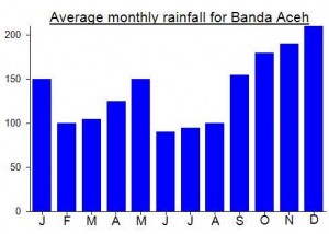
Local Average Monthly Rainfall (mm):
Location
Click on the blue arrow ![]() (top right) to see your current location on the map
(top right) to see your current location on the map
Origins and Meaning
Cot Kulam means ‘pool hill’ in Acehnese (Mark Durie, 2011).
Saya dan rekan2 sudah 3 kali naik ke cot kulam…dan memang kondisinya belum ada jalur yang jelas….dibutuhkan navigasi yang matang sebelum melakukan pendakian.
kondisi di puncak juga tertutup vegetasi dan ada beberapa lokasi yang bisa melihat langsung ke lautan…
mantab…benar2 explorasi yang seru..
Spent the long weekend on Pulau Weh. Much as I remember it from 5 years ago, but we flew in from Medan this time which made things pretty easy. The airport to Sumur Tiga accommodation is only ten minutes by car or motorbike but there are no motorized becaks at the airport and drivers will try to ask for Rp100,000 for the short journey. The offical price is Rp35,000 per person (according to the local taxi association) so Rp100,000 is fine if there are 3 of you. Weather perfectly dry in mid-February and the legendary Freddie his usual friendly self.
As expected, the beach was very difficult to get away from – one reason among many why Cot Kulam is a difficult hike despite being just over 600m. A motorized becak for a full day is now Rp350,000 so we arranged to be taken to Batee Shok the following morning at 7am. When the driver arrived, he stared at us blankly, perhaps listening for English rather than Indonesian. It does seem that given the number of foreign tourists here the locals working in tourism related businesses listen in English and also ‘charge in English’, as it were, with the prices quoted to locals and foreigners being quite different. When we got to the junction at Batee Shok (only 20 minutes max from Sumur Tiga) I got out to ask a local chap about where we might find a guide or just someone willing to lead us up the hill with a machete. It was one of those days when everyone is trying to dissuade you and saying ‘no guides, too difficult, can’t help.’
We did more asking around at the warung near the mosque in the village (80m above sea level). Again, however, locals were very negative…. ‘there are no guides here’, ‘nobody can help because they have not yet woken up yet!’ and so on. I was beginning to suggest the possibility of asking around to the west of the mountain near Keuneukai nstead, but the becak driver told us there were few people living on that side so finding a guide would be even harder and there may be no trail whatsoever. The name ‘Cot Kulam’ was not recognized by those in Batee Shok…. ‘cipron’ or ‘logra’ (both phonetic spellings only) were mentioned as possible local names for the area, but then again these words may refer to lower slopes of the range…. it was not 100% clear, and as is common in Indonesia, apparent statements can be contradicted repeatedly within just a short conversation! ‘Kulam’ is obviously linked to the Indonesian word ‘kolam’ for pool as in kolam renag (‘swimming pool’) and Cot is the Acehnese word for hill (as far as I am aware).
A small group gathered at the Batee Shok warung and started to talk of there being either Dutch or Japanese colonial remains up there…. a fortress with buried gold/treasure which can only be entered by using a key the size of a man’s forearm! They were all quite serious when talking about this, and presumably thought that was what us foreigners were most interested in, but I suggested that there may simply be the remains of a pillar up there, built for triangulation in order to make decent topographic maps. We persisted and eventually were told 2 guys (inclduing the older Pak Yahya) would come with us (they wouldn’t allow just one guide on his own) but it would cost Rp1,000,000, a huge fee for a few hours in the forest. We got them down to Rp600,000 (Rp300,000 each) which I am still sure they were pretty happy with, but myself regard as a bit excessive. Before hiking we had to wait for the second guide, the so-called ‘raja hutan’ (king of the jungle) to appear. A somewhat perplexed young man in jeans and a yellow top arrived and my co-hiker was right to think that this was none other than the king of the jungle himself!
After the guides got changed and grabbed a bottle of water we set off, and were zigzagging up the hillside shortly after. Decent views over to the Jaboi hills on the other side of the valley. Soon after the trail got tougher and aside from a few plastic markers on tree branches it appeared that neither our guides nor anyone else had been up here for quite some time. There are a couple of overgrown pondoks before you enter the forest proper, the second of which is near a small stream.
As we approached the overgrown top of Gunung Sarong Kris, a wild pig ran off, quite startled by human presence. The guides said that they were obviously not allowed by their religion to eat the wild pigs, but that the Chinese folk did. I asked if they could sell the pigs to the Chinese but apparently even that was against the religious rules. Just like throughout much of the archipelago, it is amazing to think how such a plentiful and indigenous source of food is available yet shunned in recent centuries because of an imported ideology.
Beyond Sarong Kris, the terrain got very confusing as we couldn’t see much further than the next 20 metres or so, and the shoulder connecting Sarong Kris with Cot Kulam was too broad to be easily navigable. With the help of my GPS and Google Maps terrain map we got about halfway between the two peaks in an hour or so, but my co-hiker was, in her words, ‘fed up’ and it is never much fun on a hike when others are compaining, especially when you are finding it tough yourself. It was indeed a difficult hike with no views, but negativity spreads easily and you end up thinking how much easier it would be to just turn round and go back down instead of try to convince your co-hiker to battle on and persevere for another hour to reach the summit. Something I regret now.
Back down at the village our motorized becak driver was nowhere to be seen, despite having SMSed him twice to ask him to be ready for us at 2pm. After 2 calls he finally answered and appeared 20 minutes later. I imagine he was sleeping somewhere nearby. We went for a look on the Keuneukai side and it is quite picturesque out there with some lovely beaches and a decent view of Cot Kulam (the peak is mostly hidden by Sarong Kris from the Batee Shok side).
I arrived back at the resort feeling not just disappointed but mentally exhausted, wondering why I was devoting so much time to a project that sometimes requires a lot of effort for little obvious reward. This does happen now and again of course. If there’s a view then the reward is clear. If it’s easy to find a reasonably-priced guide then it makes for a pleasant day (rather than spending over an hour trying to find someone up for wandering up the hill with us). If those hiking with you are enjoying it too then it’s good fun. It you bag it, then you can do a good write-up and think of the experience as worthwhile research. Now I am in better spirits again and see the value in the project, even without views, and even with the various difficulties. But I do regret not having battled on to the summit.
Especially as an online search I did later that evening brought up a photo of a group of hikers from Aceh mainland who had reached the top of Cot Kulam in August 2017! This was part of a major project to reach 100 or so peaks in Aceh province. Admittedly they spent a couple of full days exploring the highest peaks of Pulau Weh, something we didn’t have time for, but the photo revealed that there was indeed some sort of construction remnants from the colonial era at the top of Cot Kulam. Nothing major, no huge door or massive key, but probably the source of those stories and almost certainly the base of a trig point.
Well, at least I got somewhere near the summit this time. Failed better, as Samuel Beckett would say.
If you need transport (a motorized becak which can seat 2 people) give the excellent Mr Deni a call (085260165827 or 085270881964). No more than Rp300,000 for a full day exploring the island, including Kilometer Zero, Jaboi volcano and whatever else you want to see. He took delight in telling us he was Christian, and Christians only make up 1 percent of the population! Lovely chap with a funny laugh.
To do Cot Kulam would probably require a full day of its own in order to find a suitable guide and get up there and back down. We just didn’t have a long enough time to give it a try. Plus the beach at Freddie’s was calling. Next time.
The ferry out to Weh cost about Rp60,000, then an ojek to Freddies resort was Rp25,000. Delighted to find out that there definitely is a trail to the top of Cot Kulam and I hope to go back there before too long. In the meantime, you might want to call Ricky on 0852 60857666 who works at Freddies and can speak great English and will try to find a local guide for this mountain.