
Facts
- Elevation: 2,801 m (9,190 ft)
- Prominence: 1,492 m
- Ribu category:
 Tinggi Sedang
 - Province:
 Nanggroe Aceh Darussalam
 - Coordinates: 4.9151, 96.3288
- Rating:
 (2 votes) Add your rating
 Loading...
 - Other names: Puet Sague, Peuet Sague, Peut Sague. The true highest point in the area may be called Gunung Kemiki.
- Eruptions: 1918-21, 1979, 1986, 1991, 1998-2000
- World Ribus ID: 69082
Bagging It!
This Ribu is one of the most isolated volcanoes in Indonesia. It takes several days to reach from the nearest village and is therefore rarely visited. It has four summit peaks, which is probably the reason for its name which means ’square’ in Acehnese. The access point is the village of Lutung, which is about 200km from Banda Aceh. The path is via Geumeu plantation. Peuet Sagoe itself is only around 2,512m in elevation. The true summit is a couple of kilometres to the north-east and is labelled Gunung Kemiki on the Bakosurtanal map with a height of 2,800.6m. This true highpoint is probably very difficult to reach, being at the top of a very steep cliff which is presumably an old crater wall. It is probably marked with triangulation pillar P.133.
Practicalities
-
- Getting there: It takes roughly 10 hours to reach the starting point from Medan by private car.
- Accommodation: In view of the long journey it is a good idea to stop on the way from Medan.
- Permits: Unknown.
- Water sources: Available in various places – your porters/guides will advise how much bottled water you will need to bring.
Local Average Monthly Rainfall (mm): 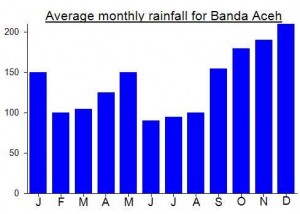
Location
Click on the blue arrow ![]() (top right) to see your current location on the map
(top right) to see your current location on the map
Origins and Meaning
Peuet Sagoe means ‘four corners’ in Acehnese (Mark Durie, 2011) which refers to the four summit peaks. Therefore it is presumed that ‘sague’ is a corruption of the original ‘sagoe’.