
Facts
- Elevation: 1,058 m (3,471 ft)
- Prominence: 966 m
- Peak category:
 Spesial
 - Region:
 Peninsular Malaysia
 - Malaysian state: Perak
- Range: Banjaran Kledang
- Coordinates: 4.7125, 101.0472
- Rating:

 (2 votes) Add your rating
 Loading...
Photos


")
Bagging It!
Mount Peninjau is a rather overlooked peak, especially given that it is the highest in the Kledang / Keledang Range. The reason that it is overlooked is that it is not so high compared to its neighbours in Perak. Yet if you consider how topographically prominent it is, it is suddenly viewed in a new light as an important mountain in Malaysia. It can be hiked in around 6 hours total and makes a great half-day out in the Ipoh area – especially as there are views from the top. The main west coast toll road / expressway actually cuts through this mountain range between Ipoh and Kuala Kangsar, so it is certainly very accessible.
From the starting point at the parking area at Ulu Chepor (90m), follow the road until the end (138m) where the proper trail begins. After a stream (124m) there are two left turns (142m and 180m) the second of which is very important. Another larger stream is crossed (251m) where there are signs of previous industry with a small cement wall constructed to change the water flow. Once over the stream (which could be classed as a river after heavy rainfall) take real care as this is the area that is most liable to being challenging to navigate after trees have fallen over or if the area has not been visited recently by hikers.
Next up is a rope section (390m) before a sign on what feels like a ridge (515m) and was once apparently used as a logging trail. Follow the ridge here past stagnant water (576m) which is only to be used in an emergency and represents the last water source on the trail. A little further along at 814m is what feels like a natural rest spot. The trail then leads on via some mossy rocks (958m and 985m) before the summit is finally reached. There is a stone marker, summit sign and a metal beirut.
Over to the right, just 15 metres away, is a partial view over the Ipoh conurbation and to the Main Range, or Titiwangsa Mountains, with Gunung Korbu as the highest peak. The name ‘Peninjau’ means ‘lookout’ and it probably refers to this pleasant spot.
Unless you are conducting an expedition of some sort, the normal route down is the same trail as the ascent.
Bukit Kledang (808m, with a prominence of 394 metres)
Bukit Kledang is a lower point of the Kledang range and a popular hiking spot for Ipoh residents. A road leads all the way to the summit as it was a colonial-era Hill Station, though there is not a huge amount of information on this on the summit are has been completely changed to make way for a large telecommunications transmitter compound. Nevertheless, it makes a great walk, and no guide is needed or fee payable.
The trailhead (116m) is completely obvious as every morning there are tens if not hundreds of local people who use the lower slopes as a place to exercise. Interestingly there are pitcher plants only a few minutes from the trailhead, on some of the many alternative routes that all lead up the mountain. The first main landmark is a shelter (267m) near a locked entrance to a seismological station. From here, you can simply follow the road all the way to the summit, though there are some minor short-cuts up narrow tracks surrounded by dense vegetation.
Several more shelters are reached before the important 4.2 location (329m) where there is a good view to the summit. Many of the hikers here will not be going all the way to the top but rather admiring the view over Ipoh before returning down the hill. The next major landmark is the 4.9 shelter (437m), which is an impeccably clean Buddhist shrine dedicated to Tuhan Gunung (‘the mountain god’). Local Chinese Malaysians look after this site and the notice clearly states that should anyone demolish this pavilion then punishment will be immediate.
Less than a kilometre further up the road is an unusual marker on the left. The meaning of Fong’s Fury (531m) is now lost to the mists of time but Fong was presumably someone who the British knew well, and this is one of several humorous markers on the road, some of which may have also been lost during road-widening works over the decades. The road continues over a small bridge over a stream (551m) before winding up past a large boulder on the left (688m) just before an important road junction (697m). To the right is a lower top, also with telecommunications towers, plus a few friendly dogs (in 2024). But the true summit lies up the road to the left, beyond the next peculiar colonial marker Isherwood’s Avenue (702m).
Several years ago, other markers including Peck’s Progress, Sly Corner, and Spooner’s Rest were noted by other hikers, though in 2024 they were not seen but could be much lower down near the start of the access track. Should any readers see them then please do comment below this article. Once round a sharp bend, the road finishes at the entrance to a compound. No traces of the original hill station are visible and no access to the compound is possible. Whether or not this is the true summit or not is hard to ascertain, but it is possible to wander a short way along the side of the perimeter fence. It takes most hikers no more than 2.5 hours to reach the top from the trailhead.
You can return by the same route, but it is far more interesting and a fair bit faster to take a short-cut through the forest heading east and steeply down via a trail junction (408m) to a stream crossing (214m). Take a left here and follow one of many paths back to the start, being careful to follow the main path or else cut down to the nearest road (95m) and either call a taxi or Grab or walk back round for a kilometre or so in the hot sun to the starting point. You should be down from the summit in 2 hours or less.
Bagging information by Dan Quinn (August 2023, updated August 2024)
Trail Map
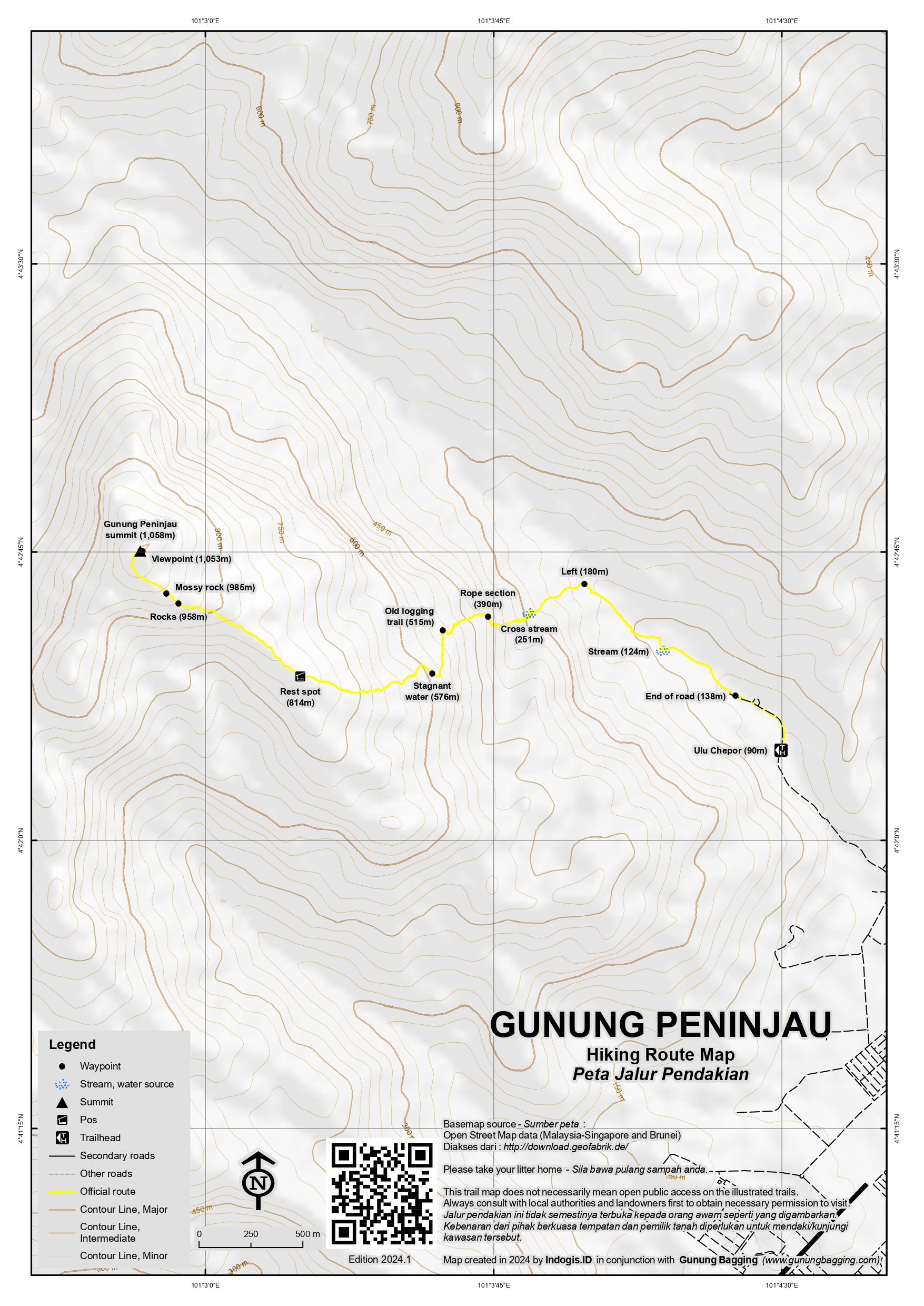
For a high quality PDF version of this and other trail maps, please download from our Trail Maps page.
Practicalities
- Getting there: For Malaysian domestic flights and flights within Southeast Asia, for example to Kuala Lumpur, we recommend Baolau. On the edge of Ipoh so it is very easy to reach, even using Grab or similar, though getting out at the end may be more difficult if you do not have your own transport.
- Guides and GPS Tracks: Want a PDF version for your phone? Looking for a guide? Need GPS tracks and waypoints? Gunung Peninjau information pack can be downloaded here.
- Permits: You need a guide and your guide should sort out your permit for you. The trailhead is closed on Fridays so best avoid that day of the week.
- Water sources: A good source at the river/stream (251m) and a spot for emergency only higher up (576m). Best take enough bottled drinks with you on what is a fairly short hike. On the Kledang trail it is not recommended to use any stream water as this is a very popular semi-urban trail with a higher risk of pollution. Bottled water is best.
- We recommend Safety Wing as travel insurance for overseas travellers and tourists hiking up to elevations not exceeding 4500 metres.
Local Average Monthly Rainfall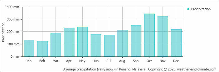
Location
Click on the blue arrow ![]() (top right) to see your current location on the map
(top right) to see your current location on the map
I found a relevant quote in Ambrose B Rathborne’s “Camping and Tramping in Malaya”, first published in 1898, which is a pretty good read and available as a Stanfords Travel Classic. On p124 (my edition) he writes that he ‘commenced the ascnt of Gunong Meerut, over three thousand feet in height, by a track leading up one of its spurs, and made more difficult from having been used in wet weather by elephants’. As 3000ft is 914m, and Meerut is probably Meru, the peak in the Kledang range immediately south of the toll road cutting though the Kledang Range, he may have been either getting his figures mixed up or confusing the name with another top. He goes on to write that ‘there was a glorious view, although seen with difficulty through the trees; on one side was the broad Kinta valley……away to the westward, across the Perak river valley, was Gunong Bubu”.
The Kledang Range was formerly known as the Meru Range.
There is a Gunung Meru under the Kledang Sayoing forest reserve. The Menora Tunnel is built underneath the range.
Interesting to read the following article on Bukit Kledang / Keledang …. which is a lower point of the Kledang range and a popular hiking spot for Ipoh residents: https://www.internationalsteam.co.uk/penang/kinta04.htm Also this one: https://malaysiatrekking.blogspot.com/2009/05/bukit-kledang-menglembu-ipoh.html
I have read that Bukit Kledang was a colonial-era Hill Station, though there is not a huge amount of information on this. The images on this page of stone markers or milestones with obviously British names are a giveaway that it was indeed a project site many decades ago… Peck’s Progress, Isherwood’s Avenue, Sly Corner, Spooner’s Rest, Fong’s Fury.
I hope to go for a wander there myself at some point.
After the Korbu-Gayong (or KorGa) extravaganza, Peninjau was a nice day-hike the following morning. My guide was excellent, good conversation, and obviously very knowledgeable, something that is important on this mountain because the trail can quickly become overgrown as it is not as popular as others. The Ulu Chepor guardhouse is open 8am-5pm except on Fridays, so the sensible thing is to aim to get there for 8am exactly and get down before the mid-afternoon rains that are so common.
The view at the top is great, and it was especially interesting to be looking back at Korbu after having climbed it so recently and seen this range from the top over there.
There is a cafe at the parking area and on the way back down after a pleasant and uneventful hike the river was full, even on a weekday, of local families splashing around and enquiring where I was from and where I was going. Two deep philosophical questions of course, which can also be answered in a simple or indeed oblique fashion!
I then headed on to Taiping, ready for the next day-hike.
A Gunung Bagging trip to Gunung Peninjau is likely to happen 24th July 2023. If you are interested in joining please reply to this message ASAP or contact via the contact page. Thanks, Dan.