
Facts
- Elevation: 1,276 m (4,186 ft)
- Prominence: 1,204 m
- Ribu category:
 Kurang Tinggi
 - Region:
 Peninsular Malaysia
 - Malaysian state: Johor
- Coordinates: 2.3733, 102.6083
- Rating:


 (2 votes) Add your rating
 Loading...
 - Other names: Ledang
- World Ribus ID: 68613
Photos


Bagging It!
Mount Ophir – also known as Gunung Ledang – is the highest peak in Johor and the only Ribu on the Malay Peninsula south of Kuala Lumpur. It is rather popular with Singaporean hikers who visit over the weekend or even do a very long day-trip from Singapore. It is located in the Gunung Ledang National Park which is near the town of Tangkak and less than one hour from Melaka (Malacca).
The mountain has been known as Mount Ophir since at least 1800 or so by British cartographers and it is not the only mountain in this region to have that name. In West Sumatra is Gunung Talakmau (sometimes spelt without the ‘k’ as Talamau), also previously known as Gunung Ophir. The word ‘Ophir’ comes from numerous ancient religious texts and refers to a mysterious, wealthy region that was supposedly rich in gold. Chinese traders actually called the mountain ‘Kim Sua’meaning ‘golden mountain’ and even today local Chinese Malaysians regard the peak as being a place of treasure.
The other name for the mountain, Gunung Ledang, is much more popular at present and supposedly originates from Old Javanese for ‘lofty mountain’. At 1,276m, it is not especially lofty when compared with peaks in Sumatra or Java, but it is very prominent and distinct from other ranges making it a genuine natural icon of Malaysia.
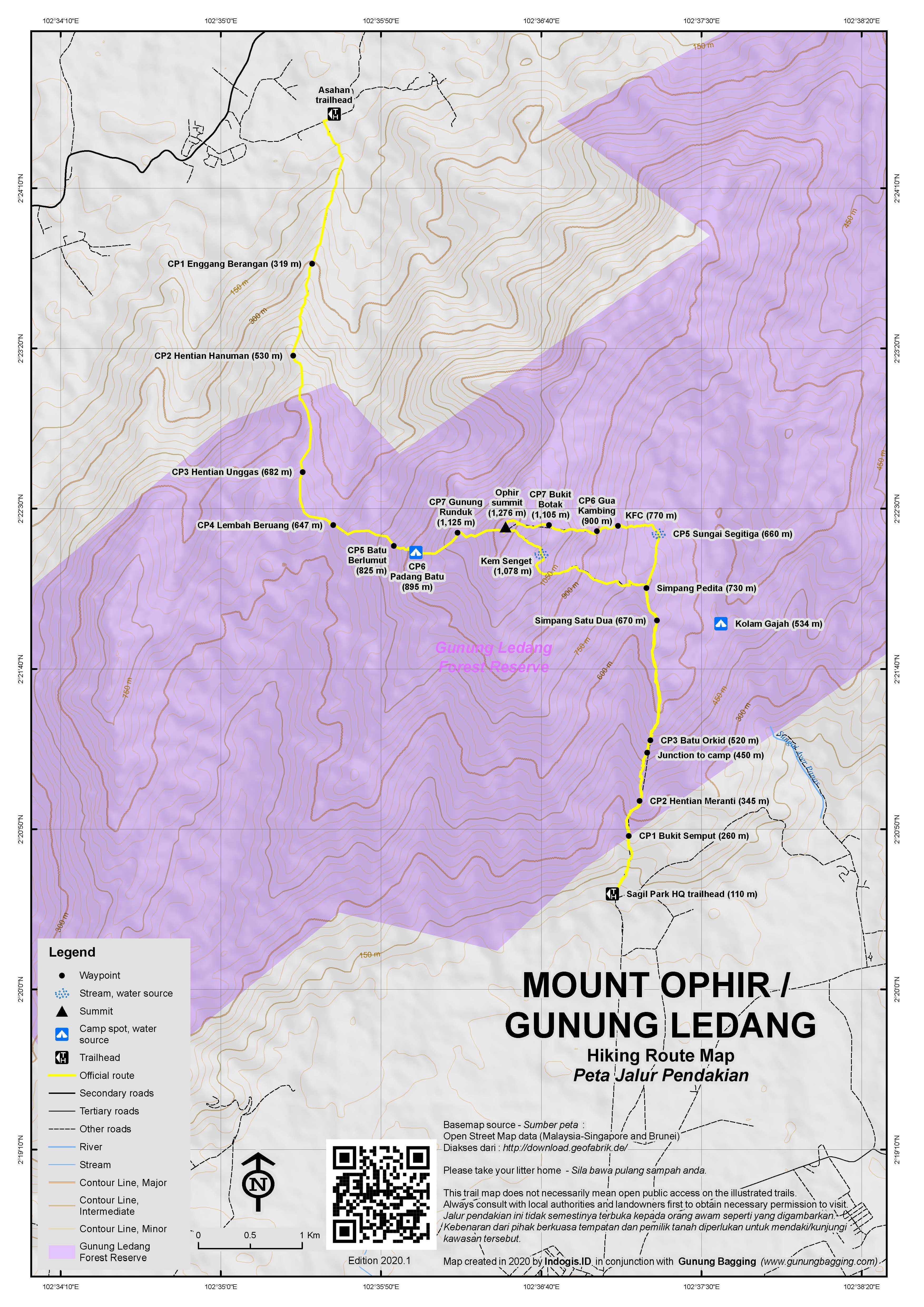
There are two main trailheads and each is quite different. The Lagenda or Sagil trail starts from the south near Tangkak at the Gunung Ledang National Park HQ. It takes fit hikers around 8 hours up and down. Most hikers complete this in a single day, but there is an optional camping area around halfway up (Kolam Gajah, Check Point 4, 534m). The Asahan trail which starts on the Malacca side (south-west) is less well-frequented. When hiked from this side, it is quite common to camp at the camp area (Padang Batu, Check Point 6, 823m) as both sunset and sunrise can be enjoyed.
Alfred Russel Wallace visited the mountain, using the Asahan (Malacca) side for the approach and hiking via Padang Batu, which he described thus: “…a steep slope of even rock, extending along the mountain side farther than we could see. Parts of it were quite bare, but where it was cracked and fissured there grew a most luxuriant vegetation, among which the pitcher plants were the most remarkable”. He also spotted rhinocerous tracks and ultimately enjoyed his time on the mountain: “…I shall ever look back with pleasure to my trip as being my first introduction to mountain scenery in the Eastern tropics“.
The mountain has been very, very popular in recent years with Singaporeans who visit over the weekend as it is the only significant peak for a very long distance. Most hikers who use the common Sagil or Lagenda trail complete this hike taking around 8 hours up and down (not including rest time at the summit).
Unfortunately, the mountain is one of Malaysia’s most expensive, despite its modest elevation. Taking a guide is compulsory, and the current (2019) price of RM152 (Malaysian) and RM218 (foreigner) for a day-hike is high enough, before you see that you have to have a minimum of 4 hikers in your group! This clearly discriminates against solo travellers or small groups, but – as a solo hiker, for example – you could probably arrange to pay quadruple which would be an astonishing RM608 (Malaysian) or RM872 (foreigner) which is a ludicrous $214 (USD) at the time of writing.
Like some other peaks in Johor, this mountain sadly suffers from being close to corporate Singapore and it means not only that non-rich foreigners will struggle to afford the costs, but local Malaysian hikers will also think twice about whether to hike here or elsewhere. It is hoped that the authorities will see sense and change this pricing system in order to quite rightly allow access to the natural environment for those on a variety of incomes rather than just the wealthy.
The higher prices have mean less visitors in 2019, and on the Sunday that Gunung Bagging climbed, myself and the guide were the only people up there. However, do note that guides here tend to be excellent (notable exception is confirmed thief Azizi who regularly worked here until July 2019 when he took the guide fee from me in advance during preparation for trips to other Johor mountains and then never showed up or responded!) and you also receive a meal pouch to eat at the top (automatic cooking without the need for a stove). Unfortunately there appears to be no vegetarian option at present.
The Lagenda route starts with a cement staircase (‘tangga mahligai’) of over 700 steps to Bukit Semput (260m, Check Point 1) followed soon after by Hentian Meranti (345m, Check Point 2). There are lots of tongkat ali trees in this area, a herb known local for enhancing male performance. You may not see hornbills here, but listen out for their flapping wings above you. After about 1 hour total you should have reached a junction (450m) where you can turn right to the camping area at Kolam Gajah or continue a little way up the main trail to Batu Orkid (520m, Check Point 3) and then Simpang Satu Dua (670m) which is where the trail via the camping area rejoins the main trail.
Beyond Simpang Satu Dua is another, more important junction called Simpang Pedita (730m) which you should have reached after a total of around 2 hours. From this point, you do not retrace your steps but rather make an anticlockwise circuit by staying right. On the descent you will meet this point again by return along the path you can see which leads down to the left.
After dropping down a little way, the next Check Point (number 5) is at Sungai Segitiga (660m, ‘triangle river’) where you cross a minor stream and then a slightly larger one. This is the last water point on the ascent. Look out for wildlife in this area including the occasionally seen Asian forest tortoise (Manouria emys).
Next comes the steepest section of the hike known by locals as KFC (‘killing fitness center’, 770m) which involves a few ladders and small roped section. After KFC is Gua Kambing (900m, Check Point 6) an area where despite the name meaning ‘goats’ cave’ you are likely to see evidence of wild pigs (‘babi hutan’). Beyond here are the most technically challenging parts of this trail with very steep rock faces with ropes across them that you need to negotiate. The second, Batu Hampar (975m) is the toughest and steepest. This area is also the best place so far for views, although you might consider it to be best to wait until you have got to the end of the roped sections before looking back down!
Beyond Batu Hampar, the vegetation grows lower in an area of mossy forest known as ‘taman bonsai’ and the views are pleasant over the forests below. Soon, Bukit Botak (‘bald hill’, 1,105m, Check Point 7) is reached and then you only have 18 or so more ladders to climb before you are at the summit itself! The summit (sometimes called Check Point 8) is the top of a large boulder which there is a final, sturdy metal ladder attached to. Views are extensive, but as most people reach this point by late morning or lunchtime it is often quite hazy.
Wallace wrote of the summit: “The top is a small rocky platform covered with rhododendrons and other shrubs. The afternoon was clear, and the view fine in its way–ranges of hill and valley everywhere covered with interminable forest, with glistening rivers winding among them. In a distant view a forest country is very monotonous, and no mountain I have ever ascended in the tropics presents a panorama equal to that from Snowdon, while the views in Switzerland are immeasurably superior.”
It may not be the finest panorama in Malaysia, but if you are lucky you will be able to make out the coastline near Malacca and enjoy the clouds swirling around the summit. You will also see the large telecommunications compound lower down the summit ridge. Anyone who has studied the mountain on Google Maps or similar will see that an access road leads up the mountain to this compound. Sad that the mountain has been disfigured in this way, but equally impressive that it only becomes clear when you reach the summit.
Those thinking that the access road might be a good way of sneaking in will be sorely disappointed. You may be able to even drive halfway up the bumpy track but you will eventually meet the traditional no entry warning signs which promise a hefty fine or imprisonment if you go any further! Even if you could, it is by no means clear that you could actually get from the compound to the summit anyway, especially given how steep the terrain is. So, best avoid even thinking about it!
The cutoff time for descending is 2pm to ensure everyone is back before dark, and as previously noted the descent route is slightly different. From the peak you will probably have seen the telecommunication compound on a lower part of the summit ridge. The trail leads in that direction at first. Shortly beyond the summit you will reach another important junction (1,250m) which is well signposted. To the right is the Asahan trail up from the Malacca side and down to the left in the trail back down to Park HQ. In the middle in an information board on the myth associated with the mountain.This is the usual lunch spot for hikers as there is a bit more shade compared with the bald summit.
There are roughly 15 ladders to clamber down before the trekking becomes much easier and rather delightful in nice weather. There is a pleasant spot by a stream with a shelter a place for Muslims to pray (1,078m, ‘kem senget’). After this, the trail leads up a little onto a lovely ridge with orchids and pitcher plants (1,105m) and one or two glimpses back up to the summit. There are apparently 3 different species of pitcher plant on this mountain.
The trail then turns sharp left (1,110m) and it is mostly descent all the way from here back to Simpang Pedita where you meet the original trail.
For those interested in trying the Asahan trail, this can also be booked via the National Park. It leads from Lubuk Kedongdong via Enggang Berangan (CP1 – 319m), Hentian Hanuman (CP2 – 530m), Hentian Unggas (CP3 – 682m), Lembah Beruang (CP4 – 647m), Batu Berlumut (CP5 – 825m), Padang Batu (CP6, 895m) which is the optional camping area, and Gunung Runduk (CP7 – 1,125m). Unfortunately there is a sign at this trailhead stating that hikers are not allowed to ascend this way and descend to Sagil / Lagenda meaning that a traverse may not be allowed.
Bagging information by Dan Quinn (February 2019, updated July 2019 after theft by guide Azizi)
Trail Map
For a high quality PDF version of this and other trail maps, please download from our Trail Maps page.
Practicalities
- Getting there: For Malaysian domestic flights and flights within Southeast Asia, for example to Kuala Lumpur, we recommend Baolau. The trailhead is near Tangkak which is just 45 minutes from Melaka / Malacca and is served by regular buses. Batang Melaka is the closest train station but is not very close!
- Guides and GPS Tracks: Want a PDF version for your phone? Looking for a guide? Need GPS tracks and waypoints? Gunung Ophir information pack can be downloaded here.
- Trip planning assistance: Would you like Gunung Bagging to personally help you in arranging your whole trip? Please contact us here.
- Permits: Required from the Mount Ophir National Park. Reserve your spot in advance via tamanhutanlagenda@yahoo.com or to staff member Muhazam via WA to +60127414385. Guides are compulsory. The more people in your group, the cheaper the cost of a guide and in January 2019 it was stated that there must be a minimum of 4 hikers in your group (which seems incredibly inconvenient for solo travellers and couples). Cost per hiker in 2019 is RM152 (Malaysian) and RM218 (foreigner). WARNING: do not employ the services of guide Azizi (Muhammad Azize Bin Zuaini) as he is a thief – see comment below for details – and is unlikely to work again in Johor after an incident in July 2019.
- Water sources: Available at Checkpoint 5 (660m, ‘sungai segitiga’) on the Lagenda route and Checkpoint 6 (895m, ‘padang batu’) on the Asahan route.
- We recommend Safety Wing as travel insurance for overseas travellers and tourists hiking up to elevations not exceeding 4500 metres.
Local Average Monthly Rainfall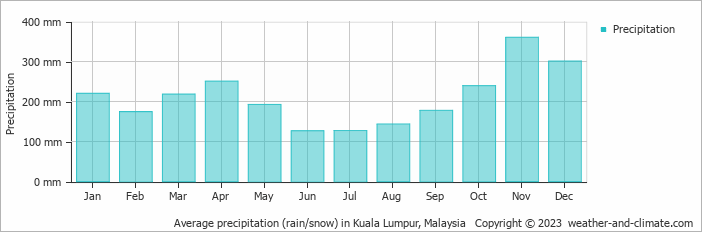
Location
Click on the blue arrow ![]() (top right) to see your current location on the map
(top right) to see your current location on the map
I had first glimpsed this mountain from the small Bukit Cina (Chinese cemetary) hill in Malacca last year. It rises from very flat land around it making it prominent enough to be the Malaysian Peninsula’s southernmost Ribu (Besar and Belumut are not that far behind though).
My next view of the mountain was unfortunately from the large Ophir quarry on the southwest side. Oil palm and banana plantations. But the mountain looks very impressive indeed with its sharp peak. In retrospect, I shouldn’t have stayed in Tangkak. It was nice to find Pizza Hut but my hotel was a real disappointment with barely working wifi and no phone line to call for a cab the next morning. I had to complain to the owner who said it was ‘intermittent’. Funny how after I got angry it started working properly!
After my co-hikers ditched me, I always knew it was going to be a very expensive hike. Indeed, about 100 times more expensive than Gunung Rembau the previous day! But with tickets booked I thought I would continue as planned, especially with such dry weather (and zero leeches!)
The next morning, no Grab drivers were available and no local taxis were ready either at 630am. This is one respect in which Indonesia is usually far better than Malaysia. So I got a lift to Tangkak bus terminal where I waited for a taxi to arrive (they are not 24 hours here so Malacca is a much better base). What happened next was quite bizarre and certainly one of the oddest taxi journeys I have ever had. I had agreed to arrive at Park HQ by 7am and was already late. The first taxi driver was an Indian man who gave me his little pink business card with his name on it In the front of the taxi sat a large Indian woman who seemed in a bad mood. There were no other taxis around so I had to agree to get in the back. He introduced her as his wife and then a Malay boy with a guitar got in the back seat with me who was introduced as his friend. Neither were neither. We set off (an overpriced RM30 to the Park) and the Indian woman in the front kept going on about getting to KL and the driver kept saying at 10am. Then her friend phoned to ask where she was and she was clearly saying something about just going round in circles. Next, the taxi driver starts trying to sell me whisky (at just after 7am) and I tell him firmly that I don’t want anything except to get to Park HQ. Then he starts smoking without asking, simply saying ‘sorry’. Next, he makes a detour off the main road and stops at a shop or café of some sort. I ask what is going on and he says he is going to buy more cigarettes. I am getting quite angry now. Then he comes back and we continue, but he misses the Park HQ turning. I tell him this and he says that it is not the correct place and I say that it most certainly is. Then he gets angry, telling me there are two Gunung Ledangs. I then get even angrier and tell him I am paying for this and I know where I want to go. He is furious and turns back, and starts complaining about me to the other 2 passengers (or should that be ‘hostages’). Finally, after the driver makes sleazy comments about female joggers on the long straight road to Park HQ, we arrive and I am glad to get out of that insane environment. What this man is doing aside from being a pest is uncertain but if I had more time I would have happily reported him. You might say that I was not entirely enamoured with him. Not that kind of person anyone would want their daughter to have the misfortune to meet.
Things suddenly got normal again once I was safely out of the taxi. I signed the forms for the hike and declared the items I was taking in (that you have to show when you leave at the end, to prove you have not left any litter).
Azizi the guide from Malacca arrived and it was immediately obvious he knew what he was talking about. Very experienced and knowledgable. And he had been up Gunung Belumut the previous day! We were lucky enough to see a tortoise just after Sungai Segitiga – only the second time in ten years of guiding here that Azizi had encountered one. I immediately thought that this might be an omen of some kind, already having my bus schedule from Tangkak to KL in the back of my head so I could make it back to Jakarta the same day! Might the tortoise represent a prophesy of a traffic jam or similar? Or was it just good luck to see one?
Azizi told me he had also seen a tapir once and a king cobra once here. The trail was really pleasant for the most part, even the difficult bits. Almost zero litter, and we were the only 2 on the mountain – perhaps due to the greatly increased prices in 2019 which might be keeping local hikers away and is obviously not great for local guides who depend on this income.
Made it to the top in 4 hours plus 20 minutes or so for breaks. A little cloudy, and I’m sure the Malacca side is quite pleasant in clearer weather. Well, my 81st Ribu, so I was very happy with that. Very nice old trig pillar too – quite unique with its maroon paint job.
We were back down in about 3 hours plus 15 min break time (at the shelter and water spot to eat the free meal). It is great that you can do a circuit in this way rather than descending exactly the same way entirely.
Had a shower, a quick peek at the herb garden, then Azizi gave me a lift to the shabby and chaotic Tangkak bus terminal where accurate information is hard to find and signage is poor. Still quite early so went for another pizza at the nearby Pizza Hut. Then I headed over to enquire about where to wait for the Cepat Express bus at 1730 (due to arrive TBS in KL at 1930 so just about enough time to get to the airport for the last Air Asia flight back to Jakarta). Alas, the spotty little specimen in the Cepat Express booth was not too keen to help with information, preferring to ignore me and answer his phone.
I asked others, and nobody else seemed to be waiting for the KL bus. Finally, a Chinese woman came and said her daughter was supposed to be going to KL but it sounded like the bus was seriously delayed or cancelled possibly. When you hear this, it usually means the worst, for it is rare for bad news to be given in this part of the world unless it really really is bad. The boy at the booth wouldn’t help much, so the tortoise prophesy was a risk of becoming reality. Given I had work the following morning in Jakarta, it was clear I could waste no time and must come up with a Plan B.
So I found a taxi driver and agreed the expensive RM250 (including toll) direct to the airport. Naturally, his AC was not working so it was a very sweaty but fast ride of 2 hours to the airport. Very expensive for a person on their own, and my wallet was by this time almost totally empty of Ringgit. So if you read Gunung Bagging and enjoy it, please do contribute so that I am able to negotiate these kinds of incidents which happen frequently – it would be much appreciated.
I made it home fine, but this weekend was a very expensive one indeed. Can Ledang / Ophir be recommended? Not to single hikers unless the authorities change the rules. To groups of 4… yes, especially if you are staying in Malacca and have your own transport. Avoid staying in Tangkak or using that shabby bus terminal. Otherwise, there are so many things that can go wrong, even when you have paid for bus tickets and so on. Just as in Indonesia, despite Malaysia claiming to be a developed country, you need to double and triple check everything, even with people whose job is to pick you up at a specified time or provide you with information. You often find you need to do it yourself!
The bus I booked was only around RM20. Probably too much trouble to try to get a refund. But as my first experience of Cepat Express I would do my best to avoid them in future. Did the bus even arrive? If so, how late was it? I have no idea….
So, it was a weird mix….. lovely mountain and great guide, but high cost and chaotic transportation. Looking forward to next weekend in Langkawi… more relaxing (I hope!)
Well, fast forward several months and Mr Azizi, a guide for Ledang for several years, has been shown in an entirely different light. Despite his knowledge and experience, he is quite simply a thief. Sad to fin this out after getting on well with him the first time.
More details will be up on the Belumut and Besar (Endau-Rompin) pages shortly, but in brief we arranged two days of hiking in Johor, I sent the money in advance, mainly due to the laborious permit procedure, and then he never showed up or answered my calls when I arrived, effectively stealing the money. Instead I spent my weekend making a police report in Johor Bahru and complaining at Johor Tourism office about the complicated permit procedure and excessive price of simple hikes in Johor. Not a great weekend.
In short, Azizi, or Muhammad Azize Bin Zuaini to give his full name, is worth avoiding at all costs. Do not trust this individual. I will do what I can to see that he never works as a guide again. If there is any justice I will have my money returned and the extra charges I incurred by having to book extra hotels paid for out of his pocket. Realistically this could well not happen, but please do not trust this ‘man’. He is a liar and a cheat and is unlikely to be employed by Johor Parks as a guide ever again after this incident as my police report has been forwarded to management.
General advice to all trekkers…. never send any money to guides in advance except if it is direct to a National Park account. There are lots of thieves out there. Don’t be fooled by the smiles or ‘friendliness’. It’s fake.
Well, about 10 weeks on from this incident and I thought I’d ask Azizi’s boss for an update. As expected, not much to report and the usual ‘not my problem’ mentality! See below!
07/10/2019, 18:24 – Messages to this chat and calls are now secured with end-to-end encryption. Tap for more info.
07/10/2019, 18:24 – Daniel: Hello there. Any news on what happened to Azizi? Thanks, Dan
07/10/2019, 20:33 – Muhazam Ledang: The solution and action has been taken by the police. There are 2 inspectors from Johor Bahru recently call me to know the situation..my site can only blacklist him from being a guide anymore..to hunt him down we let the police handle..but for more details you can call the police station and use the reference no. on your report to know the update
07/10/2019, 20:38 – Daniel: They must be utterly useless then.
07/10/2019, 20:38 – Daniel: Great law enforcement
07/10/2019, 20:39 – Daniel: And what are you going to do to prevent it in future? Better background checks?
07/10/2019, 20:39 – Daniel: Because the only reason people trusted him was because he worked for Johor Parks!
07/10/2019, 20:41 – Daniel: I certainly won’t be wasting any more of my time on it but it shows up Malaysia as a deeply disfunctional country. I never even had a reply from Johor Tourism… nothing. They clearly couldn’t care less.
08/10/2019, 02:54 – Muhazam Ledang: Do not just simply put our country name in fault@disfunctional when it is your fault at first. We and I know everyone cannot trust personally and simply give the money..why you must pay in personal account number although the national parks had its own tourism mgt system that you can pay using agency account number..
Second, do not be like this. You should look into yourself why this things happen..you already know me,should call me for other mountains information. you will be informed the right way to made the reservation, but you want to use short cut♂♂♂
You have be swindling by someone. One person..not the whole country. Bhahahahaha…
Bad things happen bro. Let it become your experiences for the next time Do not become pluralism..
I do not like the way of you said *disfunctional country* . As a blogger i can accept your opinion and i hope so do you to accept my opinion..i know you are very angry but when you said *disfunctional country* it is my country that you are blame.. i cannot simply be silent to the way of your speak..!!
08/10/2019, 05:59 – Daniel: Except that the system simply does not work for a single hiker either at Ledang or Endau Rompin. Minimum 7 people or whatever. It is a very bad system – massively overpriced to begin with. Indonesia is a tenth of the price and in the UK you are not forced to take a guide at all. So I actually felt swindled even before Azizi stole the money because I know the real cost of a guide in Malaysia and these Park prices do not usually fairly reflect that or accommodate small groups. So for single hikers or small groups the situation certainly is disfunctional. It is a shame but yes my experiences of West Malaysia have been disappointing so far. Perhaps this will improve and perhaps not but when even Johor Tourism cannot be bothered to respond to a complaint you get the feeling the authorities have no genuine interest in the wellbeing of visitors or accepting criticism to make improvements.
08/10/2019, 06:09 – Daniel: Here are my conclusions:
1. As you said, do not trust anyone.
2. Do not waste your time suggesting improvements because they will be ignored.
3. Do not waste your time doing a police report because the chance of anything happening as a genuine solution is low.
4. There is no fair price for small groups of hikers or single visitors in West Malaysia. Either pay 7 times or go somewhere else.
08/10/2019, 07:33 – Muhazam Ledang: It is a misunderstanding..it will be always solution. Even single hiker we will join with other groups
08/10/2019, 16:31 – Daniel: It is not a misunderstanding. I myself was not joined to any other groups when I visited. Probably because the excessive price has scared hikers away this year. And exactly the same scenario for Endau Rompin. Belumut is another crazy one, with a rm150 permit fee even if it’s just one hiker. The problem is a systemic one, and if such problems and greed were not institutionalized as they clearly are in Johor, then I would never have considered going privately with Azizi.
Ophir / Ledang is not a cheap mountain to do alone because you are forced to take a guide and if you are alone it means over RM300. Crazy money for a day-hike on a clear trail. I looked at groups doing this and the only one I found that fits with my schedule is a whopping 170 Singapore Dollars for a day-trip from Singapore! Unbelievably expensive – but it seems many Singaporeans are rich enough to pay such prices.
Will hopefully get a group of my own together to do this next year sometime – with enough people it is relatively cheap.
Interesting to note that an old name for West Sumatra’s Gunung Talakmau/Talamau is also Ophir.