
Facts
- Elevation: 2,855 m (9,367 ft)
- Prominence: 1,199 m
- Ribu category:
 Tinggi Sedang
 - Province:
 Sulawesi Selatan (South Sulawesi)
 - Coordinates: -2.3547, 120.0711
- Rating:

 (1 votes) Add your rating
 Loading...
 - World Ribus ID: 69144
Bagging It!
The Bakosurtanal map labels the peak Bulu Lantangunta at 2,731m but local hikers know this mountain as Kambuno and it is clear from SRTM data that the summit is at least 2,840m. It has been hiked on a small number of occasions, requiring over 1 week in total. Many internet sources state the peak is 2,950m but this seems way over what is likely to be the case. GPS readings needed!
Practicalities
-
- Getting there: Unknown
- Permits: Unknown
- Water sources: Unknown
Local Average Monthly Rainfall (mm): 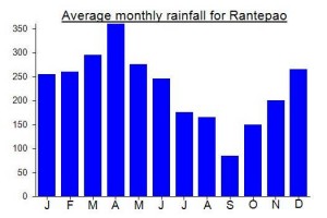
Location
Click on the blue arrow ![]() (top right) to see your current location on the map
(top right) to see your current location on the map
Minta petanya bang
Hi Dan,
You could find good enough information about mountain in Sulawesi in this blogspot :
http://ayyung.blogspot.com/2010/03/gkambuno-2950-mdpl.html
Good luck for the hiking in Sulawesi
Dasmir