
Facts
- Elevation: 2,050 m (6,726 ft)
- Prominence: 1,131 m
- Ribu category:
 Tinggi Sedang
 - Region:
 Kalimantan Utara (North Kalimantan) /
  Sarawak
 - Division: Bahagian Kapit
- Coordinates: 1.5772, 114.6138
- Rating:
 (Bagged it? Be the first to rate it)
 Loading...
 - Other names: Previously listed as ‘Batu Tiban’ which appears to be a lower, nearby peak.
- World Ribus ID: 69164
Bagging It!
Batu Tiban is on the border of Malaysian Sarawak and Indonesian Kalimantan and has traditionally been a crossing point, at least the lower slopes of the mountain and the usual height given is just 1,777m which clearly refers to a lower point of the range. Requiring several days, the usual approach is from Kapit, and up the Balleh river to Rumah Jimbong longhouse and on to Rumah Singut longhouse. The trip to the mountain region was the subject of a 1984 book by Redmond O’Hanlon entitled ‘Into the Heart of Borneo’. Mudung Dadu appears to be the name of the highest peak.
Practicalities
-
- Getting there: Unknown
- Permits: Unknown
- Water sources: Unknown
Local Average Monthly Rainfall (mm): 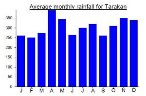
Location
Click on the blue arrow ![]() (top right) to see your current location on the map
(top right) to see your current location on the map