Facts
- Elevation: 875 m (2,871 ft)
- Prominence: 875 m
- Ribu category: Spesial
- Province: Nusa Tenggara Timur
- Google Earth: kml
- Rating:
 (Bagged it? Be the first to rate it)
 Loading...
 - Other names: Paluweh
- Eruptions: 1650, 1928, 1963-66, 1972-73, 1980-81, 1984-85, 2012-13
Bagging It!
Paluweh volcano, also known as Rokatenda, forms the 8-km-wide island of Paluweh north of the volcanic arc that cuts across Flores Island. Although the volcano rises about 3000 m above the sea floor, its summit reaches only 875 m above sea level. The broad irregular summit region contains overlapping craters up to 900 m wide and several lava domes. Several flank vents occur along a NW-trending fissure. The largest historical eruption of Paluweh occurred in 1928, when a strong explosive eruption was accompanied by landslide-induced tsunamis and lava dome emplacement (Smithsonian). Most recently, a huge eruption occurred in August 2013 killing at least six people. Previously, the last known eruption was in 1985.
Practicalities
-
- Getting there: Unknown
- Accommodation: Unknown
- Permits: Unknown
- Water sources: Unknown – assume none
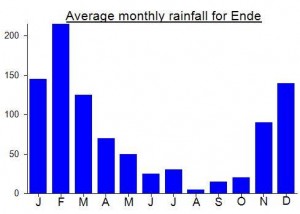
Local Average Monthly Rainfall (mm):
Coming back from climbing Rokatenda, a vulcano with 4 peaks. One is non-active and looks green and three are still very active. There are three times a week wooden boats from Maumere port, there is also now a ferry from Geliting port “Kewapante”.
For accurate and details information (e.g. local transport, possibility of accomodation on the island, climbing guide’s fee and ceremony) to visit Palue island and climbing Rokatenda, please contact Mr. Christoffer (+6281236519979). He is responsible for village’s development in Palue island but living in Maumere. He is proud and very keen to show his fatherland (Palue island).
Climbing up and down from Uwa village, including walking around 4 tops takes around 7-8 hours return. It’s very risky and dangerous to go up to craters of the active volcanoes. We took firstly an motor ojek until the last village up in the mountain, bought a chicken for sacrifice ceremony, then started walking through bushes and field. Guide is necessary since the path is fully covered by plants and along the path we didn’t meet anybody until almost to the edge of vulcano. There we met another man who killed and grilled the chicken. The heart of the chicken is needed to be offered to the mountains, the rest can be eaten together. There is no water source along the path and the island self doesn’t have much water source except collecting rain water and condensing steam water of the vulcano using bamboo pipelines. Nice island, very original and friendly, helpful locals, prepare to stay/get stranded at least 2-4 days on the island. At the moment there is still no electricity on the island.
Photos can be found on the attached link
Huge eruption today killing at least 6….
http://www.bbc.co.uk/news/world-asia-23646467
Looks like Rokatenda is blowing its top at the moment.
http://www.thejakartaglobe.com/home/east-nusa-tenggara-volcano-erupts-two-others-on-alert/549779
Does anyone have any photos of this?