Facts
- Elevation: 439 m (1,440 ft)
- Prominence: 439 m
- Ribu category: Spesial
- Province: Kepulauan Riau (Riau Islands)
- Google Earth: kml
- Rating:


 (10 votes) Add your rating
 Loading...
 - Other names: none
Photos


Bagging It!
Although this peak is a lowly 439m high and the hike itself takes just 3 hours in total, it is a worthwhile excursion for people living in Batam and Singapore. In clear weather you can see the tip of the Malaysian peninsula and the city of Singapore from the tower at top and – unsurprisingly given that it’s the only notable peak in the area – the mountain can be seen from the road bridge connecting Singapore with Malaysia.
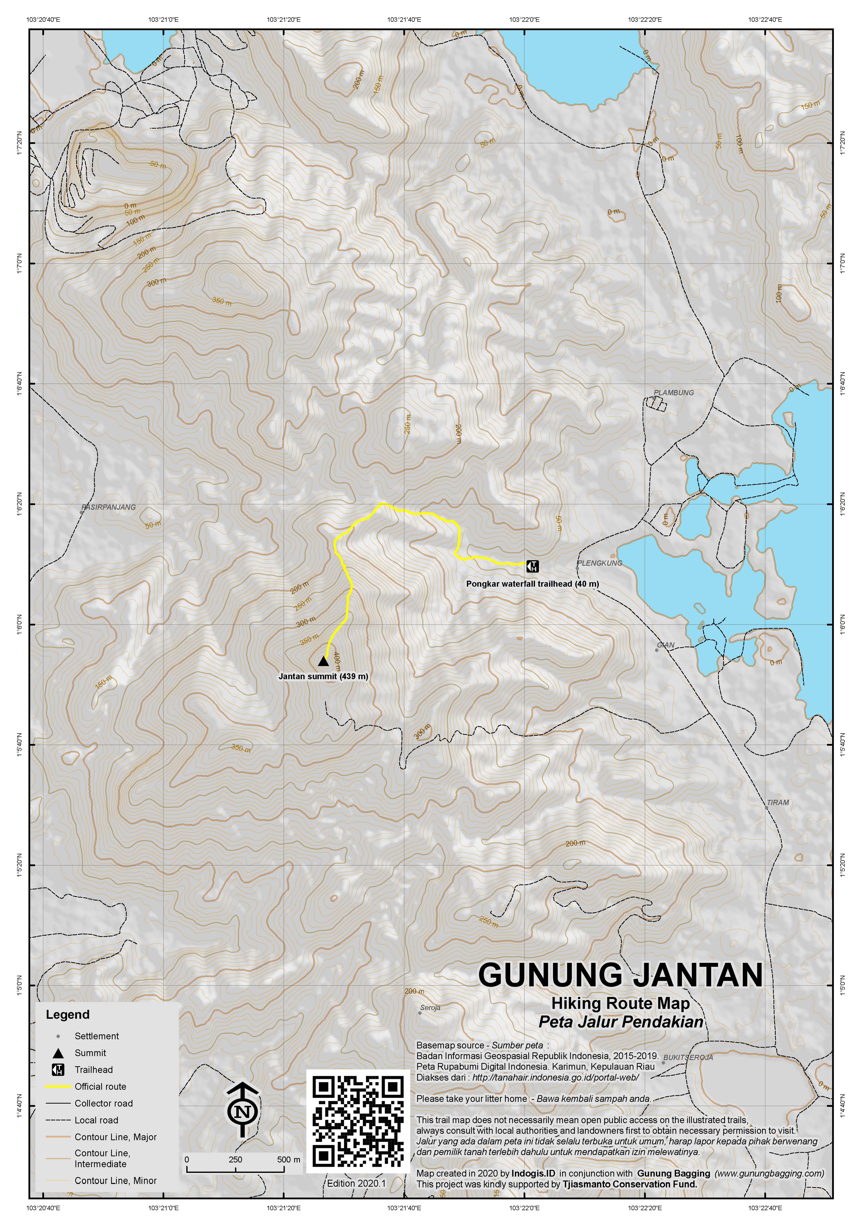
Jantan is the highest point of Karimun island and there are very regular ferries to the main port of Tanjung Balai from Batam’s Sekupang ferry terminal or direct from Singapore. Tanjung Balai itself is a friendly yet unattractive town but once you head north towards the mountain the landscapes are very pleasant and unspoilt for the most part. The best route to the top begins at the popular and well-known Air Terjun (waterfall) Pongkar (40m) which is about 30 minutes by motorbike or car from Tanjung Balai. You can see the transmitter tower and compound from the road for many miles around.
From the (disappointing) waterfall, there are a few paths leading off into the forest so you may need to ask for local assistance as there are no signposts for Jantan. The trail is slightly overgrown at the start but after about 20 minutes the ridge is reached (120m) and the trail improves significantly. There is a trail leading down the other side of the ridge (to another starting point) but to reach the summit you must take a left turn straight up the ridge. The trail is very steep in places and there are some impressive large boulders on the way up. Because the hike is not so high above sea level the humidity and temperature can be overwhelming and your clothes will probably end up completely soaking in sweat. So, it is best to have a change of clothes, take plenty of water with you and climb as early in the day as possible.
After less than 90 minutes you will have reached the summit which is just above a large boulder outcrop and is crowned with a large cement compound and rusting metal tower. There is also a cement trig pillar in the compound. To get the impressive panorama of Singapore and the Malaysian peninsula it is necessary to climb up a few of the steps on the side of the metal tower. Take care because it is falling to pieces and sections higher up the tower have completely collapsed. In good weather you will be rewarded with a very interesting view indeed.
You can return the same way in an hour and enjoy a kelapa muda (young coconut juice) at the waterfall.
Bagging information by Daniel Quinn.
Nominated as a Spesial by Chris Whiting.
Gunung Bintan, Pulau Bintan (c360m)
Another hill worth hiking is Gunung Bintan (also called Gunung Bintan Besar and Gunung Bentan) on the island of Bintan. It’s the highest peak on the island of Bintan and can be done quite easily in a couple of hours. The trail starts at a low elevation of only around 30 metres just off the main road between Tanjung Pinang and Tanjung Uban. On weekends there is usually someone manning the entrance gate as it also leads to a small waterfall (‘air terjun’).
Follow the steps up to the waterfall (60m) and unmaintained toilet building. After the end of the steps, the trail continues to the left of the waterfall after which an unsignposted junction is reached. Continue to the left. The trail now becomes steeper with ropes to help you. There is a lot of wildlife here, with birds and some of the largest ants in Indonesia! After a large rock (140m) the trail crosses a stream (155m) which could be used as a source of water but it is best to bring enough of your own. The trail continues steeply but clearly until the end of the roped section (231m) where the terrain flattens a little. A pos (259m) is reached where it is clear locals sometimes camp. This spot is also the easiest place to become lost so take care.
After the pos, the trail continues upwards and at an elevation of around 300m there is more rope to help you on the final ascent. Eventually you will see the summit tower in front of you in a small clearing. For the best views, hike up the metal steps but be very careful as the building is not maintained. In the summit clearing there is also a triangulation pillar (seemingly labelled P1 on the stone) and a second, lower shelter. In 2021 there is also a signpost erected by the local nature lovers’ club Mapala Hang Tuah.
It should have taken most hikers about 1 hour to reach this point. GPS devices give readings of around 342m at the top. However, on some online maps it appears the western top of a similar height may be higher (360m). Unfortunately at present there appears to be no trail to the western summit. It takes only 30-40 minutes to return the same way to the trailhead.
Bukit Timah, Singapore (approximately 164m)
Those wanting to bag the highest point of Singapore will no doubt be unsurprised that it is a very easy outing, but it can be combined with the Central Catchment Nature Reserve and MacRitchie Nature Trail in a point-to-point walk of around 11 kilometres.
Starting in the west at Hindhede Drive, follow the obvious signs and road up the side of the hill and into Bukit Timah Nature Reserve. This is a popular spot with local walkers and joggers and probably the only remaining primary forest in Singapore. It is also popular with monkeys but be sure to refrain from feeding them as the fine for doing so is astronomical!
Most walkers will be at the top in less than 30 minutes. The final, most direct trail leads up some steep steps and onto a short boardwalk next to a compound with severe-looking keep out signs before emerging in a clearing where there is a telecommunications towers, a shelter and an inscribed summit stone ‘Bukit Timah 163.63m’. You can return the same way or continue beyond the summit and follow the wide track as it loops back round. Note that an unmarked spot in forest around 300 metres west of the ‘tourist summit’ may be a similar height or possibly even higher and therefore the true summit and country highpoint.
To continue eastwards on a more rewarding trek, head down the Catchment path which brings you out at a cleared section of land popular with mountain bikers. Take a right here (downhill) and bear left onto Rifle Range Road. This is the least inspiring part of the half-day out, as it crosses BKE (Bukit Timah Expressway) and leads past numerous restricted-access compounds.
Finally you will be back on a proper trail which seems to be an area with a population of wild pigs. The trail veers right towards the Jelutong Tower, but a hundred metres before the observation tower is the important junction where you need to decide to either take the Nature Trail via the ranger station and path to the north of the reservoir or the southern path which skirts the edge of the reservoir and an extensive golf course.
Whichever one you choose, be sure to climb to the top of the Jelutong Tower first for a decent view over Singapore’s wildest zone, and note that there are well-constructed boardwalk sections on both potential routes from here. Look out for eagles, herons, monitor lizards and so on. Fit hikers can complete the full trek from the base of Bukit Timah to the MacRitchie Reservoir cafe and car park in around 3 hours.
Trail Map
For a high quality PDF version of this and other trail maps, please download from our Trail Maps page.
Local Accommodation
Practicalities
- Getting there: Regular fast ferries from Batam’s Sekupang terminal (1hr, Rp70,000) or Singapore’s harbourfront.
- Guides and GPS Tracks: Want a PDF version for your phone? Looking for a guide? Need GPS tracks and waypoints? Gunung Jantan information pack can be downloaded here.
- Trip planning assistance: Would you like Gunung Bagging to personally help you in arranging your whole trip? Please contact us here.
- Permits: Not usually required, especially if you start your hike early in the day.
- Water sources: There is a stream on the lower slopes of the mountain but it is best to take enough with you than rely on natural sources.
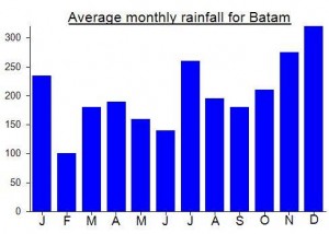
Local Average Monthly Rainfall (mm):
Location
Origins and Meaning
Literally ‘male’, ‘masculine’ or ‘manly’ mountain in Indonesian.
Rob W and Deividas recently visited Bukit Timah and reckon that the tourist summit is a few metres lower than the unmarked western summit about 300m away, which they think is possibly as high as 176m. See Peakbagger: https://www.peakbagger.com/peak.aspx?pid=10959
However, also see this excellent blog post on History Delocalized which suggests that the tourist summit is higher than the western summit, but only by a very small margin: http://historydelocalized.blogspot.com/2020/12/?m=0
In brief, it gives the following summary:
“To summarize, the heights of the four highest summits of the Bukit Timah Ridge is given below in round brackets. The square brackets give the prominence of the summits, which is its height minus the saddle point with its parent summit (in this case, the East Summit).
East Summit (163.63 m)
West Summit (162.8 m) [14.6 m]
South Summit (146.6 m) [11.1 m]
North Summit (141.9 m) [14.9 m]”
Had a very pleasant short ‘stroll’ up Gunung Bintan last week. We hired a car in Tanjung Pinang and this made life much easier than trying to rely on public transport or have any hope of getting back into town afterwards.
There was nobody at the entrance or indeed on the trail so I wandered up alone, though an old sign at the trailhead suggests you find a guide (but where from if there is nobody there). If you are experienced and have an online map on your phone or a GPS device then it really isn’t necessary.
The commonly-visited peak may not be the highest one as the western top seems to have more contour rings on online maps.
I was at the top in about 50 minutes and back down in 30.
Thought I ought to finally give Singapore’s natural areas and mighty highpoint a try. Bukit Timah was actually pretty enjoyable, when combined with the reservoir trail and only took about 2hr45min at a leisurely pace from start to finish. No view on Bukit Timah itself but the Jelutong Tower is a place to linger a while. Quite reasonably priced cafe at the end point too (assuming you do west to east). If getting the bus back at the end (recommended), you need to cross over the road using the footbridge to the farthest (3rd) road assuming you are heading back to the centre eg Orchard Road area.
I got another bus down to Sentosa Island (previously known as Blakang Mati!), which has some artificial beaches made with sand from Malaysia and Indonesia but is worth an hour or so (though weekends might be awful). The tiny and accessible (by a pleasant bridge) islet off Palawan beach claims to be the Southernmost Point in Continental Asia but it is neither part of the continent nor the southernmost spot in the area so the claim is as fake as the beach itself! Worth a quick look though.
I took some picture above big solid rock (before tower) in Gunung Jantan.
We need to climb wood branch ladder to access. Be careful when climb the rock, rock surface may be slippery. I do not recommend to conquer that point without safety gear. It’s your own risk.
It is true what u wrote
Nice to see ur description of TBK