
Facts
- Elevation: 2,227 m (7,306 ft)
- Prominence: 1,625 m
- Ribu category:
 Tinggi Sedang
 - Province:
 Nusa Tenggara Timur
 - Island: Flores
- Coordinates: -8.8781, 120.9544
- Rating:

 (16 votes) Add your rating
 Loading...
 - Other names: Inierie
- World Ribus ID: 69065
Photos


Bagging It!
Inerie is one of the most popular peaks in Flores and its beautiful pyramid shape is clearly visible for many, many miles around. It has not erupted for many centuries but has an incredibly impressive crater. It looks incredibly steep and there is indeed a reasonable amount of volcanic scree to negotiate but if hiking up the conventional route it is reasonably straightforward, although gloves are a very good idea because a slip could lead to cuts and grazes on your hands.
The 2.5 to 4 hour trek to the summit is usually started in Watumeze village (1,100m) which is just 15 to 20 minutes by car from the nearby town of Bajawa. It is a good idea to start this hike early in the morning (leave Bajawa at 5 am, start hiking at around 5:30 to 6 am) because there is no shade on the hike, and sunny weather can make it very hot as you climb the eastern slope. This is one of the few mountains in Flores where you might actually meet other hikers (apart from Kelimutu of course!) The trail leads past several bamboo houses before ascending up what looks to be grassy hillside but is covered in small rocks making walking a little less easy than you might expect. The grass continues way up the mountainside, getting rougher as you get higher up. You enter a patch of trees at around 1,810 m, but above them the more serious climbing up the side of the rocky cone properly begins. There are some deep ravines either side of the trail but route-finding is straightforward and the climb is not dangerous – at least on the way up.
In about 2 to 3 hours you should have reached the rim of the crater (2,115m) to be rewarded with extensive views. To reach the summit you can follow the edge of the crater in either direction so you might as well do the loop for the full 360 degree view into the crater. In 20 to 30 minutes you should have reached the highest point, marked with three metal crosses.
On the way back down take care to find the same route you came up on because the deep ravines mean that heading down the wrong way requires a long re-ascent to join the correct path – the trail at this point is not so clear so it is quite easy to make this mistake in bad weather! Take care on the descent and take it slowly because it is very easy to slip on the scree and you can easily slip and end up with a few cuts or grazes – this is why gloves are a very good idea. For the most part the descent is slow going but there is one area (approximately 1,880m down to 1,810m) where you can save time by sliding down deep volcanic scree just to the left of the trail. Remember to join the path at 1,810m however and be careful not to send bigger rocks hurtling down towards your companion hikers! Walking poles would be useful for the descent.
Bagging information by Daniel Quinn and Andy Dean
Kawah Wawomudha (Wawomudha Crater Lake)
To the north of Bajawa is an excellent crater lake well worth visiting. Known as Kawah Wawomudha, it is part of the Inielika volcano complex which erupted in 2001 but has been relatively quiet since. To walk to the viewpoint (1,570m) over the craters and lake takes around one hour from the village of Ngora Nale (1,373m).
Trail Map
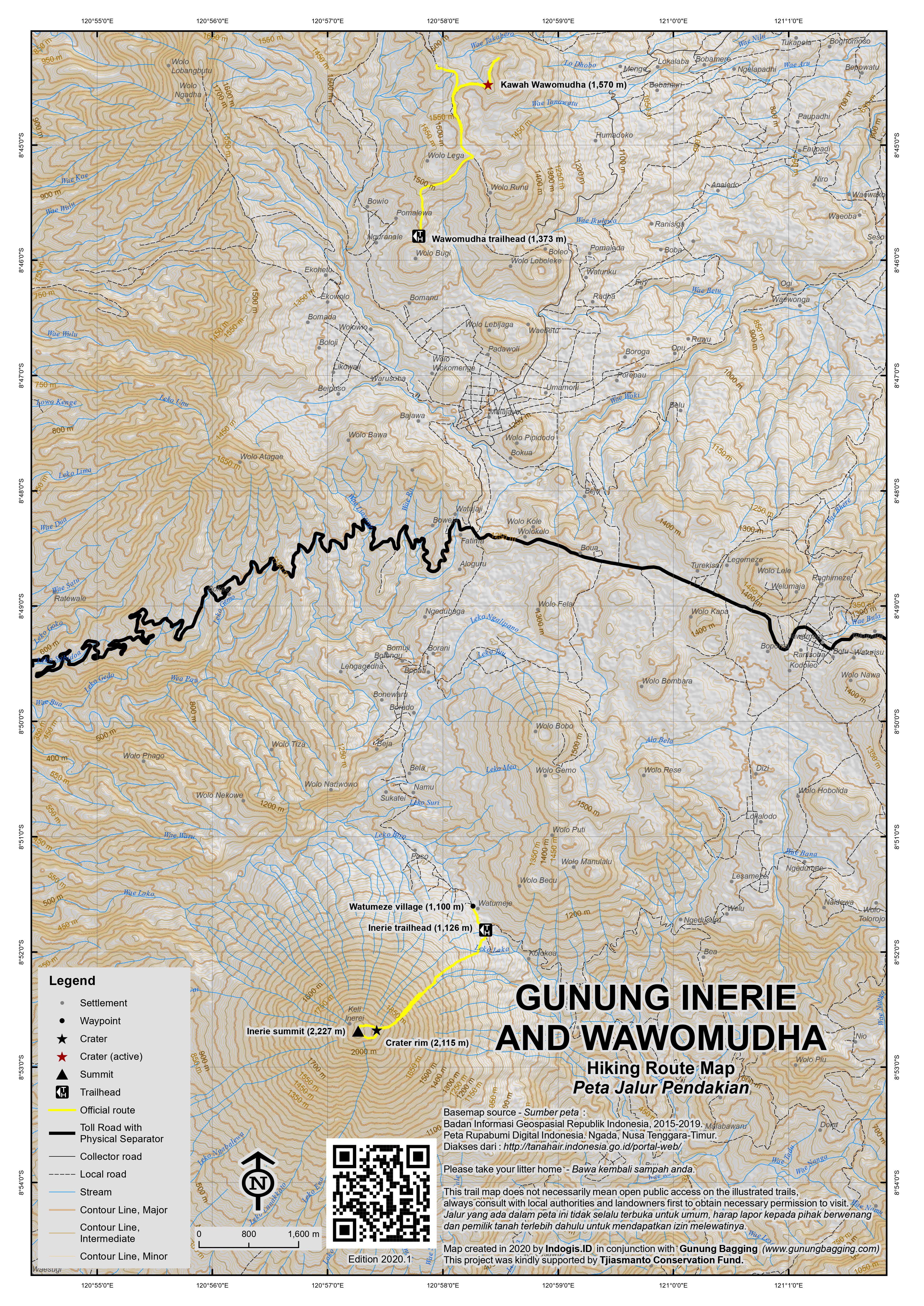
For a high quality PDF version of this and other trail maps, please download from our Trail Maps page.
Practicalities
- Getting there: Ojek can be arranged in Bajawa for the 20-30 minute journey.
- Guides and GPS Tracks: Want a PDF version for your phone? Looking for a guide? Need GPS tracks and waypoints? Gunung Inerie information pack can be downloaded here.
- Trip planning assistance: Would you like Gunung Bagging to personally help you in arranging your whole trip? Please contact us here.
- Permits: None required but take a photocopy of your passport photo page just incase.
- Water sources: There is no water on the hike, or to be purchased at the start of the hike. Buy sufficient supplies in Bajawa the night before you hike.
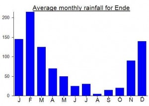
Local Average Monthly Rainfall (mm):
Location
Click on the blue arrow ![]() (top right) to see your current location on the map
(top right) to see your current location on the map
I climbed Inerie in mid-December with my recommendable guide Ignasius (+6282145976672), who charged Rp400,000, including the ojek ride from Bajawa to the trailhead in Watumeze, and a post-hike trip to Malanage Hot Springs, which are a 20 minute minute ride further south.
We left the hotel at 02.00, but didn’t reach Watumeze until 03.00, as we interrupted the motorbike ride to shelter from heavy rain. Luckily though, the rain held off for the whole time that we were walking on the mountain, and the mix of overcast and sunny skies gave us some good views while reducing the risk of sunburn.
We reached the crater rim just before 06.00 and the summit just before 06.30. Circuiting the crater anti-clockwise, I found that the ascent to the summit seemed straightforward, but the descent on the other side was slippery and very taxing; of course, the same might apply if you go around clockwise! The sign at the summit gives the altitude as 2245m, compared to the 2227m stated here, and 2221m on my GPS. We spent about an hour touring around the crater, enjoying the views over Bena and the local villages, toward Ebulobo and beyond. We could also see two chains of high peaks in the west of Flores, but it’s hard to work out exactly which they might be.
On the descent, we surfed the scree left of the trail from about 1900m down to 1450m. It’s quicker and gentler on the knees than walking down the path. But you need to watch out for tree roots and large rocks that might trip you. And you will probably need to sit down, by accident or design, for regular rests.
We got back to Watumeze at 10.30. The Malanage Hot Springs are a great way to relax afterward. Hot and cold streams roll down the mountain from different directions and you can enjoy the mingling of currents in the broad pool at the confluence.
Trip to Wawo Mudha
We went to Wawo Mudha lake the next day. The motorbike ride from Bajawa to Ngoranale is about 15 minutes, and the farm track leading up to the lake turns off the road a few hundred meters after the village. A trail bike could get you up nearly all the way to the lake, but there would not be much point, as the hike was a pleasant 90 minutes stroll up to the hill crest at 1597m, where there is a picnic shelter, and a ridge leading to a good viewpoint. Reportedly, at one time the lake was an unusual deep red colour, and a fee was charged to view it. But as it has now transformed to a thick, yellow-green colour, somewhat reminiscent of an abandoned quarry pond, the entry fee has been waived. There is probably a route to scramble down to the flat area around the lake shore, but not directly from the viewpoint area.
Thank you for the reference, John. Ignasius turned out to be a big disappointment for us when we ascended Inerie with him earlier this week: he steadfastly ignored my repeated requests to provide a price quote for our group of ten over the last 1.5 months, eventually saying that we should discuss it when we climb. He then asked for Rp. 2 million, and when I pushed back, he menaced to involve the police.
Otherwise the path was severely damaged, especially higher up, due to very heavy rainfall in May and June.
Just climbed it
At the bottom: after turning right from the main road on a gravel path going to a church, stop at a big sign in Bahasa Indonesia. At the last House, take left of it to find a path behind the house going to the left (when seeing upwards). There’s a streamed, CrossFit as the path continues to the left and slightly goes up through eucalyptus
From there it’s kinda easy to follow the path til the summit
Very steep from the Big Tree near 1800m . Very slippery as well until the rim. The last 200m to the puncak can be a bit delicate if strong winds and not good shoes
Be ready for a grueling descent. Take extra care and follow the microravines up. Near 1900m you can use the fast way on powder+gravel on the left (when looking down). If you have stick it’s possible to do it til an Indonesian flag around 1400m. Extra care tho. If not,. Join the path at the Big Tree
Enjoy!
Did Inerie with two local guides last week, to clean up the trash left by independence day revelers while helping local guides who are desperate from some income. The descent through the thick scree is now about 300-400m long, making it even more enjoyable and fast. But I would strongly recommend taking a guide because finding the path at the bottom and at the top is not easy.
Climbed it independently in January 2020. Thanks to all for your helpful comments! Guide is not needed but please be safe, let someone know where you are and bring a phone with a sim in case of emergency. Use the GPS track on maps.me and wear gloves to protect your hands. Get an early start to avoid the scorching sun. Go slow and above all enjoy!
I just hiked Inerie this morning. I have chosen to be at starting point at 5:30AM. Maybe for sunrise tour a guide could be useful to show the best steps in the dark, only for this once the trail is very strait full and very clear. If driving on your own on Watumeze village goes until the sharp left curve(you can park at the house on right side). There you turn right to a dirty road and turn right again after 50m. You can park here also. This is the starting point. Start to walk and more 30m pass between 2 houses and leave the wood hut on your left and bamboo tree also on left. Trail starts at 1050m. The only possible confusion is 100m after bamboo there is another trail to the right. Take it!!!!! Maybe both paths converge again but don’t risk. The trail follows some eucalyptus bush until 1350m and then becomes very step. With very good hiking shoes I felt safe and good traction until 1850m and then starts to be very slippery as reported on previous reviews. This tough terrain lasts until 2050m so you gonna be in hell for 200m. After that in my opinion conditions back to normal(or at least better) until reaching the crater rim at 2130m. I suggest keeping moving anti clockwise to the summit, easy, more 10 to 15 min you are there. The day was amazing. Beautiful view 360 including Ebulobo Volcano just 27km east. I took 01h 55m to reach the crater rim at good pace and 01h28m down. The 200m I mentioned is really bad walking down. Not even my Salomon could avoid two falls. Gloves(wearing socks would be ok)are definitely recommended or trekking poles or both. I started my return at 08:40AM and there is no shade. Sun was already cooking brains even early in the morning. Conclusion: this is relatively fast hiking but you need to be a bit in shape and I strongly recommend good hiking shoes. This is not the place to have a twisted ankle so think before every step. Basic precautions you gonna be fine.
Tip 1: after backing to base camp drive strait to the Hot Spring 6.5km after Benna village downhill. You gonna feel so relaxed like the chicken in the soup.
Tip 2: check weather forecast at http://www.mounting-forecast.com. Just choose Inerie. Cloudy conditions will be a complete waste of time and energy. You won’t see anything and maybe very cold.
We rented a motorcycle in Bajawa and rode early in the morning to the trail start. Local woman offered to look after the bike at her house, which was at the start of the trail.
Took us 3 hours up, to the top, the trail was a loose on the way up.
We met good 40 young people descending Inerie, some of them barefooted, running down like mountain goats.
The views from the top were quite nice looking at the sea on one side and gunung Ebulobo at the other side.
The way down was much trickier, we got cheap gloves in Bajawa and were happy to have them to keep the hands protected from the sharp stones while breaking few near falls.
Tried to use the loose scree for a part of the descent as it was easier then the steep trail, it took us 3.5 hours on the way down.
Climbed Inerie in December 17.
From Watumeze it’s pretty straighforward. From the main asphalt road, you have a dirt road on your right, take it. After 30m take right again, you pass between 2 houses, on your left there is a small cabin, turn left immediately after you passed it. This is the path until the summit.
Started hiking at 5:30AM. Reached the rim in 2 hours and additional 20min to the summit. Descent from the summit took me about 2h15min.
Weather was really clear before 7 and then some clouds came in. During some part of the descent the visibility was poor due to thick cloud. The GPS is helpful to make sure you dont get off the path in this case.
I confirm you can surf down the red scree area until the end or just choose to use to skip most of the tricky part.
Pretty good views during all the hike and I had the volcano for myself.
Just a 2017 update. Conditions are more or less the same. We went up in 3 hours and down in a bit less. I would like to add two specific things to the stories below:
1. This is maybe not super hard on the body but the upper parts of steep rock and loads of scree make for the necessity of a very careful ascent and an even more careful descent. Don’t come here of you want to walk to a summit. The little bit to the top takes care as well. You do not want to trip and start gliding down here. At the very least you’ll be black and blue and scratched. Having said this, it is doable and very much worth your time. Just be careful.
2. Earlier the red field of scree was mentioned as shortcut. You can “surf” this to the very end now and still meet the path. It seems to save you about 400 meters of descent, including large bits of the trickery parts.
All in all this is a great spots that sees relatively small amounts of visitors and offers gorgeous views. Take care and enjoy!
I went up Inerie yesterday with a friend. We went to the village the night before and wanted to camp at the start of the trail in order to make an early start. Soon after we put up our tent the dogs started barking and everyone from the nearby houses gathered to say hi. They all wanted to invite us to stay with them and finally we were put to sleep on the floor in one house. The local people wouldn’t take no for an answer – extremely friendly people.
We started climbing after 2 am in clear weather but by 3 am the sky and the mountain were covered by thick clouds and it started raining. We waited a bit and decided to come down and try another day in better weather.
By 8 am when we were planning to go back, the sky cleared up suddenly and I decided to give it a second try alone. The route is as described here and it is very easy to follow the trail. There are also markings in red paint here and there.
The last one third is indeed very slippery. Since I didn’t have gloves, I wore a pair of extra socks on my hands.
Once at the rim, it is possible to get to the highest point clockwise or anticlockwise. The path to the right (anticlockwise) is more slippery and hazardous than the other way.
Hi,
I climbed Gunung Inerie last week. I did it alone using gunungbagging GPS track and started to walk around 8am. Most of the climb was in misty conditions but just 200m before the summit the sky cleared and I could enjoy the views from this peak.
Surprisingly the track was very clean and the little garbage I saw I collected it and took it with me. I hope that this mountain stays this clean always.
Hey pedro!!!!
Lo qe decis del gps esta marcado por alguna parte de la web?
Gracis
Climbed Inerie today with quite a bad cold – I was stuffed by the end! We got a great experienced guide from the nearest village (Watumeze) named Franciscus. He is like a gazelle!
Though I’m quite fit, having a cold knocked me about a fair bit. We set off at a cracking pace at around 9am, but the slope soon became steep, and had to stop a fair bit on the ascent. About 400m from the top, the loose scree made the climb quite tough, though Franciscus was running up through it at times!
It then started to rain, and became very misty. By the time we got to the top, I was wrecked! We missed out on the views due to the rain (a 3am start would have been better), but still pretty stoked to reach the top.
The loose scree was horrible on the descent, plenty of sliding going on (except for the nimble footed Franciscus). Thank God for good footwear and gloves!
Our water ran out half way down, and I stuffed by the time we got to the bottom. My mate went off to get some water, and Franciscus invited me into his house to keep warm by the fire. Seeing I wasn’t too well, his wife gave me some balm to put on and his wife fixed us some delicious coffees. The Floresians sure are a hospitable bunch.
See http://www.peakbagger.com/climber/ascent.aspx?aid=131200 for Rob Woodall’s account of our recent climb.
i have climbed a number of volcanos in indonesia and i must say that this one almost killed me.its no more than a three hour walk to the top but the terrain is steep and slippery with volcanic rock that cuts you everytime you fall over.make sure you bring lots of water including some for your guide.i brought 1 bottle of aqua for myself but my guide who had never set foot on the mountain before(he tells me this halfway up) didnt bring any so i shared and ran out at the top.heatstroke on the way down was enivitable.my guide climbed in bare feet and got us lost.was lucky a 6 year old kid came out of a hut and showed us the way.great views at the top but to be honest not really worth the struggle.hands down my favourite walk was kerinci in sumatra .you wont be dissapointed.
Its location—looming over the traditional village of Bena , and overlooking the beautiful coast line—its conical “near-perfect volcano” shape, and the prospect of a challenging day out combined to make an attempt on Gunung Inerie irresistible.
I “bagged” Gunung Inerie on April 10th with a good guide from the nearby town of Bajawa (Mikel—HP 085253267929), and his friend from the village at the base.
It was a very tough climb and a thrilling/perilous descent. On the other hand, we had magnificent views and the whole mountain to ourselves. We took lots of water: about 3 litres of water per person (our friend from the village had 1.5 litres of luminous green “Extra Joss” and serious food/snacks. This is a hot climb, and there is hardly any shade.
We set off at 0300 from the village at the base. The first part of the trek, about 1.5-2 hours, was fairly straightforward and not too steep. We stopped for a while to admire the fabulous sunrise over Gunung Ebulobo, then clambered over a large rocky outcrop. After that, the going got tough! From the big rocks to the summit is basically straight up across a slippery combination of hard rock and scree surface, and no real “trail”. The small, gnarled shrubs on the way up make good handholds. It’s basically a “full contact” experience: you and the mountain side. It gets hotter all the time.
There are 2 “summits”. The first is the crater rim which gives you a terrific view of the peaks and craters of Flores (including Mt Ebulobo and as far away as Ende), the coastline, the village of Bena, and Bajawa in the distance. The second “summit” is slightly higher (about 150-200m) and requires a short descent, a traverse around the crater and then a shortish climb up another slippery slope, with almost no vegetation. The views are similar, though you get to see the Western part of Flores.
The way down is hazardous. Near the summit, the combination of hard base and thin scree is very slippery, and is much worse than on the way up. There are some small ravines you can walk down at various points, but they are quite deep and narrow so not such a good option. Every step requires great care. You have about an hour of this (depending on how confident/reckless you’re feeling) before you have an option of descending via a wide ravine and a much looser red sand/scree slope. Go for it! If you’re in a group you need to stick quite close together to avoid injuries from falling/flying rocks. We managed a considerable distance in a fairly short time and were soon covered in red dust. After the thrill has worn off and your legs start to feel less rubbery there’s another fairly long slog down the “trail” on the lower slopes (which somehow feels much longer than on the way up) before you get back to the village. All in all, allow for 8 hours plus stops. We spent about an hour at the top; cup of tea would have been grand!
excellent post natasha.your description is exactly as i remember it.could you imagine how my guides feet looked climbing to the crater in bare feet.he wont be doing that again.congrats on bagging it.something i failed to do.
I started at 2am and arrived on time for sunrise. Please don’t expect the view to be anywhere close what you can see on Merbabu, Semeru or Rinjani. It was just ok but there was no entrance fee, so do it if you like for sport/exercises… I went solo with an engish-speaking local guide for 300k. Be careful with guides in Bajawa who would ask you for an outragous 500k for guiding. They would give you tons of reasons for asking a price which is much more expensive than guides in Java, Bali or Lombok, despite the fact that the treks are much less demanding. Use local guides instead. Some of them can speak english as well and know the mountain better.