
Facts
- Elevation: 1,742 m (5,715 ft)
- Prominence: 863 m
- Peak category:
 Spesial
 - Province:
 Jawa Barat (West Java)
 - Coordinates: -6.9341, 107.8819
- Rating:

 (9 votes) Add your rating
 Loading...
Photos


Bagging It!
Gunung Kerenceng is something of a hidden gem, lying so close to Bandung but little-known outside of local West Java hiking clubs. It can easily be climbed as a day hike, taking no more than 2-3 hours up and 2 hours down. The summit area is a tiny equilateral triangle with sides of just 3 metres and is where three narrow mountain ridges meet. Kerenceng is very accessible but the views from the top easily fool you into thinking you are in a much more remote area.
For those who are happy to have a quick weekend trip out of Bandung or Jakarta this is the perfect mountain. Indeed, you could even do it as a (long) day trip from Jakarta. The closest place to stay is the modern and well-signposted Pondok Wisata Aki & Enin (850m) , a popular place with Bandung’s middle classes at the weekends. Note that there aren’t many rooms so you need to book well in advance. Otherwise you’ll have to either camp or stay in a tree-house at the end of the road at the Gunung Masigit Kareumbi conservation area (1,200m) or simply stay in Bandung instead.
From the Cicalengka bypass it takes about 15 minutes to reach Aki & Enin and a further 20 minutes to reach the conservation area at the end of the road. The area is popular at weekends because of the impressive Curug Sindulang waterfall which is on the left side of the road about halfway between Aki & Enin and the conservation area buildings.
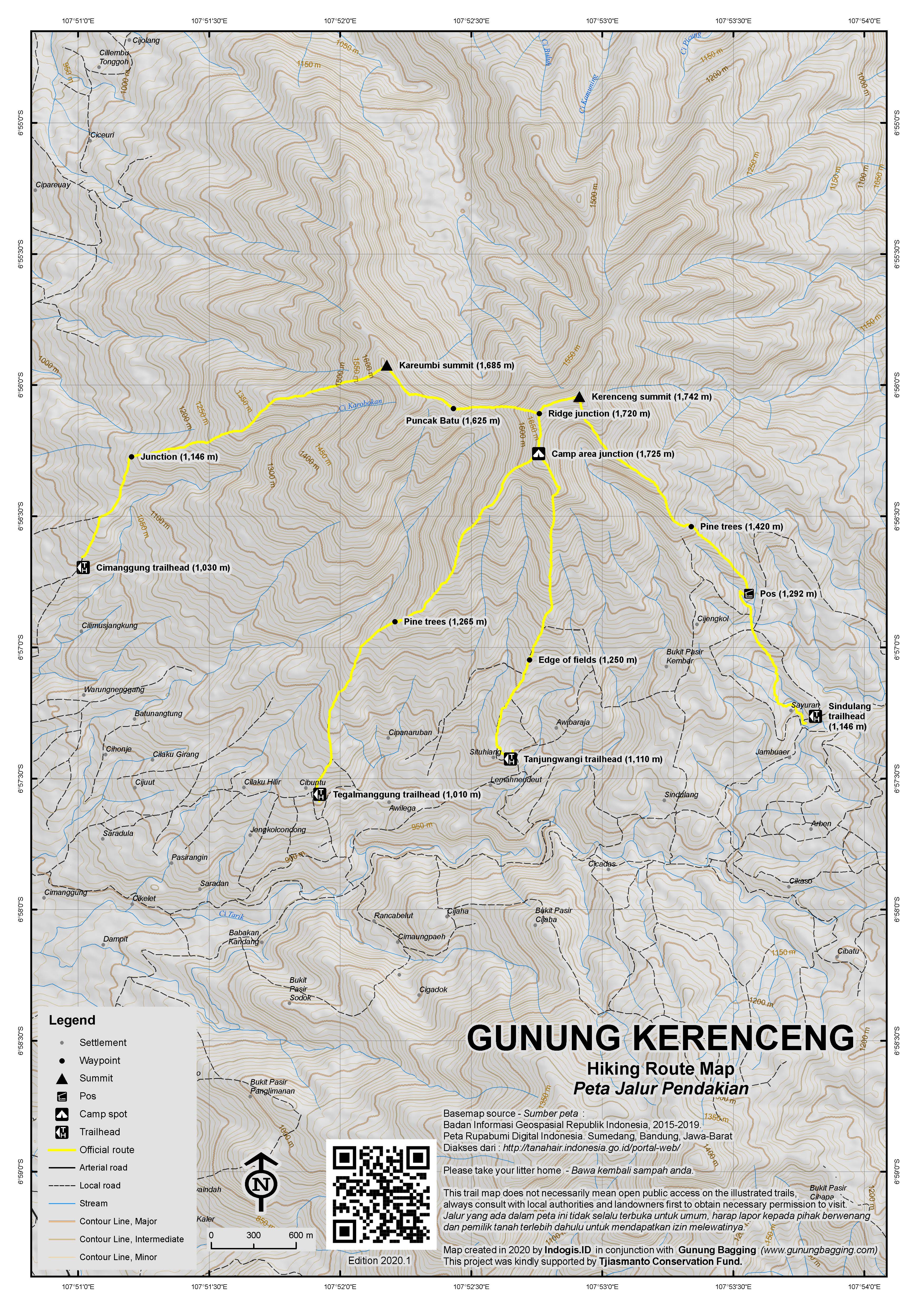
Guides are available at the conservation area and are happy to take you up to the peak of Kerenceng (the highest point in the conservation area) at whatever time suits you. There are several trails, with the easternmost Sindulang trailhead (1,146m) being the closest to the conservation area.
The trail actually starts a little way back down the road at the last village and leads up through villagers’ vegetable fields including cabbage, bean and chilli. The little peak visible on the right is Gunung Buleud (1,423m). As with all trails of this sort there are many junctions between farm plots so a guide is almost essential.
After less than an hour from the last village you will be beyond the last of the farm fields and into the pine woodland. The ridge flattens for a while and views in all directions begin to open out. After dropping down into a little crevice and then back up again the ridge gets narrower and narrower and the pine trees become less and less in number. At this point you will see the tiny summit area ahead of you at the end of the ridge. As you get closer to the top you will need to exercise more and more care as a slip here really would have disastrous consequences. Those with a fear of heights may have difficulty on the final section climbing up to the tiny top.
Once on the little summit you will be rewarded considerably for what is a very easy hike with a brilliant panorama of genuinely wild areas of West Java. If you found the route up difficult, consider how much more difficult it would have been on either of the other two ridges that meet at the Kerenceng summit. To the left (west) is a knife edge ridge leading to a nameless peak with a height of 1,709m and on the right (northeast) is a jagged ridge leading to a nameless peak with a height of 1,610m and Gunung Pangukusan further round. The latter of these is an alternative route for those approaching the mountain from the Sumedang side. Straight in front of you is a massive, near-vertical drop down into a remote forest area which appears to be full of bird life. If you’re lucky you will be surrounded by swallows as they swoop around the airy summit. Gunung Kareumbi (1,685m) lies just under 2 kilometres to the west.
After admiring the excellent view, head back the same way to the village and the main road up the mountainside. It shouldn’t take more than 90 minutes to descend to the road where there are plenty of villagers happy to give you a ride back down to the bypass at Cicalengka for just Rp20,000 or Rp30,000 where you flag down a Primajasa bus and be back in Jakarta in no time. However, you might want to call off at the Sindulang waterfall before heading home.
The other routes are as follows (from east to west): From the Tanjung Wangi trailhead (1,110m) a trail leads up through farm fields and onto a ridge where there is a camp spot (1,725m). This is where another trail joins up from the Tegalmanggung trailhead (1,010m). Beyond the camp spot, the trail reaches the summit ridge at a junction (1,720m). Turn right here to reach the summit in less than twenty minutes and meet the trail up from Sindulang.
If you turn left at the ridge junction, you can follow the very narrow main ridge westwards via Puncak Batu (1,625m) which is unsurprisingly a rocky area and reach the summit of Gunung Kareumbi (1,685m). From here a trail descends to the west and down to Cimanggung (1,030m) which is the fourth and final of the four starting points used by local hikers.
Other nearby peaks
There are many other mountains in this region of West Java and it is a very popular area for train photographers to take pictures of Kereta Api services running through this beautiful part of Indonesia between Bandung and Tasikmalaya, with the various hills as the backdrop. Indeed, during any hike in this area you are very likely to hear the sound of a train passing through the valleys below. Here are some of the most notable:
Gunung Mandalawangi (1,660m)
Lying to the west of the main Garut-Nagreg road and to the north of Gunung Guntur, this range has around four separate peaks, the highest three being the true summit, a northern top (1,595m on the Bako map) and a southern top called Gunung Masigit (1,618m on the Bako map) where there is a small military monument. Despite its considerable height and location not too far from Bandung, it is not hiked regularly and is easy to become lost on, so taking a GPS device and ideally someone who has already explored the mountain is highly advisable.
The highest peak is in the centre of the range and is best accessed from the north at Bojong, Nagreg. The end of the bumpy farm track is at around 990m above sea level and has several brick production buildings. Follow the narrow plantation path southwards as it leads into the dry river valley between the highest peak and a lower, 1,500m+ peak to the east.
At an elevation of around 1,305m there is a very important and un-marked trail junction. Do not continue to follow the main trail southwards as it becomes increasingly slippery and treacherous before reaching a dead end. Rather be sure to turn right (west) up towards the ridge of the highest peak.
The trail seems to disappear and re-appear frequently so GPS and local experience is essential to avoid becoming horribly lost! The next key landmark is a small Pos (1,390m) which feels like the start of a ridge. After this the terrain begins to flatten slightly as you make your way towards the summit.
The summit features an old grave, apparently the tomb of Nini Ranteng, with a small wooden fence around it. There are no views but it is a pleasant spot. Do watch out for leeches in the Mandalawangi forest, however, as there are a few more here than on most mountains of Java.
It should have taken you between 2 and 3 hours to reach the top. To get back down to the village takes around 1.5 to 2 hours, assuming you navigate well.
Gunung Kaledong (1,251m)
This shapely little mountain lies to the east of the main road to Garut. Gunung Kaledong can be hiked from several directions but is overgrown and despite being a small mountain requires up to 3 hours to reach the top. It is probably best accessed from Ciherang (756m) on the main road to the north-west. From here, follow the cement path up through the village, then the plantation tracks to the end of the fields and the start of the denser vegetation (931m).
In this area are several jackfruit trees (nangka) which if in season is some small reward for having to deal with a steep, very overgrown and seemingly pathless terrain! At the summit there are two small clearings just 50 metres apart. The southwestern one features an ancient grave and a yoni stone said by locals to be used as a mortar and pestle for pounding rice and other things. The northeastern one has a small depression and a cluster of stones plus (in 2020) a summit sign.
Gunung Haruman (1,217m)
Appearing almost like Kaledong’s twin, Haruman is another independent hill further east of Kaledong and not far from Candi Cangkuang. An important Muslim grave site of Sunan Haruman lies on the eastern side of the mountain and is regularly visited by local people. Of course, the name alone, originating from the Hindu god Hanuman, tells you that the history of the mountain goes back to way before the arrival of Islam.
The lower top (Pasir Nangkod 951m on the Bakosurtanal map but more commonly known as Haruman Jingga) is actually used for paragliding and there is a wide but muddy farm track all the way up there from the west side at Harumansari. This track first skirts round a much smaller, sharp side-peak called Pasir Leutik (815m). The views to Gunung Guntur, Mandalawangi, Kaledong and the city of Garut are fabulous.
To reach the true summit, however, you need to leave the wide paragliding access road at a sharp bend at around 850m and follow a narrow path into the scrub. Apparently there is a rock vaguely resembling a horse (‘batu kuda’) at the summit. From reports it seems there are no views at the top. It looks to be fairly similar to the summit of Kaledong, in terms of vegetation, so a lack of proper trails and high risk of getting lost is to be expected.
There are several ‘summits’ of a similar height, with the south-eastern one being the highest according to the Bakosurtanal map. In 2017, one hiking group made a traverse from Harumansari over to Cipareuan, Cibiuk on the east side but it took a full day! Such is the slow going of progress due to the dense vegetation.
Gunung Geulis (1,281m)
Lying to the west of Gunung Kerenceng, near the end of the toll road at Cileunyi, this is a more popular mountain and located pretty close to Bandung city. It is a shapely and individual peak, quite separate from all others. There are several routes up the mountain, the best of which is perhaps from Jatiroke to the west of the peak.
From Jatiroke, it takes only 90 minutes to the top. Motorbikes can be left at the warung at the end of the road (775m). The track leads to the right of a quarried area, past farm fields and is soon quite thick with bamboo. There is not much in the way of proper forest remaining here, so it is best to avoid the middle of the day because of the lack of shade.
The summit plateau features several spots of interest of unknown antiquity. First of all, a shelter with a grave inside is reached, just before an impressive wall with buttresses which encloses a tiled area and shelter. Between the first shelter and the walled compound, a trail leads down a few metres to yet another shelter which houses another grave. Beyond this third building is an opening which allows great views to the east and north, with Kerenceng, Tampomas and Manglayang all visible in good weather.
Back up near the walled compound, follow the trail along the top of the ridge for just two minutes to the wooden summit sign and numerous little camping spots. To the right (west) is another clearing which in good weather affords views over the Bandung plain to the Malabar range. In very clear conditions you can sometimes see Gede-Pangrango in the distance to the west beyond the city of Bandung. And finally to the south, the numerous tops of Gunung Mandalawangi can just about be seen over the summit vegetation on Gunung Geulis.
Allow just one hour back down to Jatiroke or one of the other trailheads.
Bagging information by Daniel Quinn (updated January 2021)
Trail Map
For a high quality PDF version of this and other trail maps, please download from our Trail Maps page.
Practicalities
- Getting there: For domestic flights from or to West Java, such as the airport in Bandung, we recommend Baolau. Very easy from both Jakarta and Bandung. The best public transport option is to take a Primajasa bus bound for Tasikmalaya or Garut and simply get off at Cicalengka. From Cicalengka, take an ojek up the road to Curug Sindulang (the waterfall) for the Sindulang route, or alternatively try one of the other nearby starting points.
- Guides and GPS Tracks: Want a PDF version for your phone? Looking for a guide? Need GPS tracks and waypoints? Gunung Kerenceng information pack can be downloaded here.
- Trip planning assistance: Would you like Gunung Bagging to personally help you in arranging your whole trip? Please contact us here.
- Permits: No pieces of paper needed, but it’s best to at least speak with the manager at Kareumbi conservation area first.
- Water sources: None on the hike itself but you shouldn’t need more than 2 litres given how short it is, unless you are doing a full traverse via Gunung Kareumbi.
- Accommodation: Try the Booking.com map above or use this link to search for suitable hotels, homestays, resorts and apartments for your trip.
- We recommend Safety Wing as travel insurance for overseas travellers and tourists hiking up to elevations not exceeding 4500 metres.
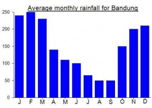
Local Average Monthly Rainfall (mm):
Location
Click on the blue arrow ![]() (top right) to see your current location on the map
(top right) to see your current location on the map
Did a hike up Sadakeling the other day, but as I arrived in Cibatu at 0233, we had extra time so we decided to take the motorbike back up Haruman again, on the wide track up from Harumansari, to the hang-gliding/paragliding spot ‘paralayang’ at Haruman Jingga. A couple of steep sections but mostly OK on a normal motorbike if you don’t mind getting a bit muddy.
Up at the top, the constructions are quite significant – a large sheltered seating area with benches, a traditional house and a rather attractive mosque. We waited for the sun to rise as the bamboo creaked and a night train chugged across the fields and stopped at Leles station far below. Bad weather sadly, the whole week has been very wet, with serious flooding in places including Semarang. However, even with low cloud, the view at first light was impressive across the Garut plain. The slightly higher area behind the mosque is great for looking over to Gunung Kaledong.
Near the final steep section up here is a narrow track leading into the scrub (at around 920m). Could this lead direct up to the summit of Haruman? We didn’t have time to check this time…… I’m surprised this spot is not more popular than it is….
Gunung Geulis may not be all that high but it’s a great morning out. We hiked at night, arriving at the top well before 4am. The sound of the mosques was quite intoxicating, across the whole of the Bandung Plain below. After first light, we found an opening to look over to Kerenceng to the east – lovely as cloud was swirling around the peak. Several other mountains also visible in the distance, and near the summit sign we could even see Gede-Pangrango to the west beyond the towers of the city of Bandung, being lit up as the early morning sun rays hit the buildings. Quite fabulous – much better than expected. And the grave compounds – not much information on these but they look pretty old. All in all, a very interesting little mountain.
Originally planned to attempt 4 gunungs in 2 days…. all the ones between the end of the toll road and Garut that I hadn’t done before, namely Haruman, Kaledong, Mandalawangi and Geulis. All quite small, so looking at the map not a tough proposition.
Alas, there are only 2 trains running each way from Jakarta Gambir to Bandung at present so time was a bit more limited.
From Kiaracondong station we (me plus Pepep and Abdul of the Gunung Institut in Bandung) set off to do little Kaledong first. Still good weather for November, so good in fact that is was absolutely roasting with the sun on our backs as we strode up to the edge of the farm fields above Ciherang where we had left the motorbikes.
It ended up taking us 2 and a half hours to the summit and about 1 and a half back down, mainly due to the lack of trail. You are continually working your way round rotting branches and trying to find the path of least resistance. Very interesting summit area, though, despite no views. Highest GPS reading was around 1257m so Bako may be a little under with their 1251m..
Once we reached the edge of fields on the descent it was raining and we didn’t have much time left for Haruman, second on the list. But we decided to take a look anyway, to see if the village road shown in Google Maps running to near the summit actually existed or was a total fabrication.
By the time we were on the road between Kaledong and Haruman the weather had improved and the post-sunset panorama of rice fields and Gunung Guntur was beautiful. It turned out the wide track did exist behind the village of Harumansari, but there was a branch blocking the way, as if left there on purpose. Closed due to covid? That old chesnut?
Well, we got round anyway. It was almost pitch black by this point but we could see the light of Garut below. This would be a lovely place to watch sunrise or sunset. On the track there are one or two bamboo warungs and a deserted building of some sort. Above 850m, it seemed we were heading in the wrong direction. Indeed, the track was leading us south and not taking us much higher. We decided to turn back.
At the point where the track diverges from what is shown on Google Maps, which is at a sharp corner, there is what appears to be a narrow path leading on towards the summit, but we didn’t have the time to investigate. But this point would be the way in from the track and you’d have less than 400 metres of ascent left (but probably a lot of dense vegetation!)
Back down in the village, folk at the shop said if we had carried on along the track we would have reached the paragliding area. Indeed, the much lower peak is used for this. But do not mistake this for the true summit because it is a good 300 metres or so lower, nomatter what anyone tells you!
We stayed with friends up in Cijapati on the southern slopes of Gn Mandalawangi where we were heading the next morning. At about 1070m so a lovely night-time temperature. But the best access for Mandalawangi is from the north, at least if you want to reach the highest top. On the Bako map, the highest peak does not have an elevation figure but it’s around 1660m (highest GPS reading was 1664m).
We got a bit lost on the way up Mandalawangi – a common experience here, even with GPS and local knowledge! We went to far, had to do a u-turn and locate the hard-to-find spot where a vague path leads up to the right towards the summit from the dry rrverbed valley. Allow extra time, look out for leeches, and take a GPS and compass etc etc. Very atmospheric at the top. There was a temporary shelter made from branches up there near the ancient grave. But last time my friend had been up here he had said there was a stage, and a simple seating area, as if some important meeting or performance had occurred! Apparently some locals hike here on a Friday as a local pilgrimage, but looking at the trail or lack of it, with it disappearing and re-appearing as often as the vegetation changed slightly, it seems like less people have been up here in recent months.
There was a local hunter and his dog looking for wild pigs, but we never crossed paths. Quite a few monkeys in the trees and a couplee of very loud frogs or toads really croaking away.
By the time we got down to the mosque where the bikes were left it was approaching lunchtime and the prospect of hiking the shadeless Gunung Geulis in a rush before getting the train home was not appealing so I decided to leave it til next time and feast on tahu sumedang at Cileunyi instead.
I just climbed Gunung Kerenceng with my guide Mang Acong. We started at the Sindulang trailhead. I could not agree more with the description, it is a hidden gem, very pleasant. Conditions were perfect (mid July) and we passed by only 5 climbers (COVID time). When you start the hike, you pass by some vegetables plantations. 2 hours to the top. The last 30 minutes are steep. The summit is super small, 6/7 people maximum and you can see 5 surrounding mountains/volcanoes when there is good visibility like I had. Strongly recomended.
Min boleh minta info tentang titik awal pendakian gunung pangukusan
— starting point
If you want to target a GoogleMaps starting point :
https://www.google.com.my/maps/place/Cicalengka+Sindang+Wangi,+Cimanggung,+Sumedang,+Jawa+Barat+45364,+Indon%C3%A9sie/@-6.9579405,107.8815711,17z/data=!3m1!4b1!4m2!3m1!1s0x2e68cf755519ca19:0x63ed4dfa26bb1388?hl=fr
You’ll need to ask couple of times your path in the farm-fields.
!! Once you hike on the East side of the mountain. You will have to take a left (going up) at a point. There is a small inscription “OJ=” at this intersection. The summit is 45 min further.
Take care, we got caught in a forest fire and had to climb down in the wild.
We saw Eagles and Bores.
is that possible to make a camp around the summit? or are there any spot to camp near the summit?
You might fit one tent on the summit, Dony. But you wouldn’t want to roll out and over the cliff by mistake! There are a few spots just below the summit that would be ‘ok’, though I cannot remember how flat they were.
There was a lot of litter at the top, but it was heartening to see that both the young Sundanese guys accompanying us were also disappointed to see it and quickly set about stuffing a substantial amount of trash into a bag they’d brought along for that purpose. They were also cleaning the trail as we walked up and down.
As for “exercising mass control on top,” one of the guys with us told me that people in the villages around Kerenceng claim that no matter how many people climb up there, they’ll all fit. Maybe that’s why there was a lot of garbage?
Indeed, Rick. Not only did the guides clear up, they were also incredibly pleasant and genuine lads. Pak Darmanto (manager of the conservation area) seems to have a very nice bunch of staff. I won’t forget the 24-hour warung that Ibu was looking after at 3.50am!
While I remember, Rick, please have a look at the NTB page (https://www.gunungbagging.com/province/nusa-tenggara-barat/) and see if you can work out which mountain you were on when you hiked in Sumbawa and whether or not you can roughly locate the village of people with pale brown eyes. As I mentioned, we currently have no information for any peaks on that island except for Tambora.
This peak was a real surprise. I had heard from Java Lava’s circular that the summit was pretty special but nothing quite prepares you for the sudden view you get at the top.
After visitng Cangkuang temple near Leles I got an ojek all the way to Cicalengka (to avoid the nausea and horrors of sitting in angkots while the driver searches for passengers and stops every couple of minutes). I didn’t know what to expect with the Pondok Wisata Aki & Enin but it turned out ot be in a beautiful location – in the middle of rice fields and next to a little river. Wonderful. But remember to bring beer as they don’t have any. There’s even a little karaoke area. I was lucky to get the very last room available which wasn’t cheap but for the location it was worth it. The security guys agreed to take me and my companion up to the end of the road to meet our guides the following morning for a 4am start.
After an interesting chat with the Ibu who runs the place, and lots of cake, and some endearingly out-of-tune Sundanese karaoke I headed to bed for 5 hours of sleep.
We were at the conservation area by 4am and after being slightly overcharged by the Aki and Enin security guys we started to look around for our guides. Took a while as they were still asleep! Anyway we were off by 4.30am and up on the peak by 6.30am. Not the finest of weather but what a view from the top. Tens of swallows circled the peak and the mists began to rise slightly but remained substantial enough to make neighbouring peaks and ridges look rather majestic. Java Lava’s comment that they ‘may have to exercise mass control on top’ was actually pretty apt given the lack of space. Quite difficult to get more than 5 hikers up there without being worried about people falling over the edges.
The only sad thing about the summit was the amount of litter left by previous hikers. When will local hikers learn to have a little social conscience and clean up after themselves?
We were back down in no time and onto ojeks past the market stalls overlooking the vast plains of Bandung and down at the Cicalengka bypass. The traffic was brilliant, still being so early on a Sunday and it can’t have been more than about 4 hours from the top of Kerenceng to the Kampung Rambutan area of Jakarta!