Facts
- Elevation: 844 m (2,769 ft)
- Prominence: 844 m
- Peak category:
 Spesial
 - Province:
 Lampung
 - Coordinates: -5.9543, 105.4828
- Rating:
Photos
Bagging It!
This 844m high island lies in the Sunda Strait just 12km north of the Krakatau islands and is usually accessed by boat from Carita, Banten or Canti near Kalianda, Lampung. It is actually much cheaper and a shorter crossing from Sumatra, and a hike to the highpoint of the island can just about be done as a regular weekend trip from Jakarta. Just over 2,000 people live on the island – an interesting mixture of ethnic groups: Javanese, Batak, Ambonese, Sundanese and others – but it’s a really relaxing environment and quite popular with visitors from the Lampung mainland.
The tiny Canti pier is about 5km south of Kalianda town, beneath the steep slopes of Gunung Rajabasa. It’s an incredibly laid-back place and there is just one public ferry serving Sebesi per day. The crossing takes 90 minutes and the ferry leaves Sebesi at 7am and returns from Canti at 1pm. It usually calls at Sebuku island enroute – an large and wild island which looks uninhabited but is actually home to a not insignificant population. As the ferry nears Sebesi island, you will see a further island in the distance – that is Rakata, the highest remnants of the original Krakatau volcano.
Once the ferry has docked at Sebesi pier, it is just a two-minute walk to Pak Hayun’s Villa Pondok Sebesi Indah – the basic accommodation on the island. The rooms are literally a stone’s throw from the beach, and if you walk for ten minutes in either direction you will find some delightful and empty beaches to explore. Pak Hayun can arrange anything you need – be it a trip to the Krakatau islands (a further 90 minutes) or a hike to the summit of Sebesi island.
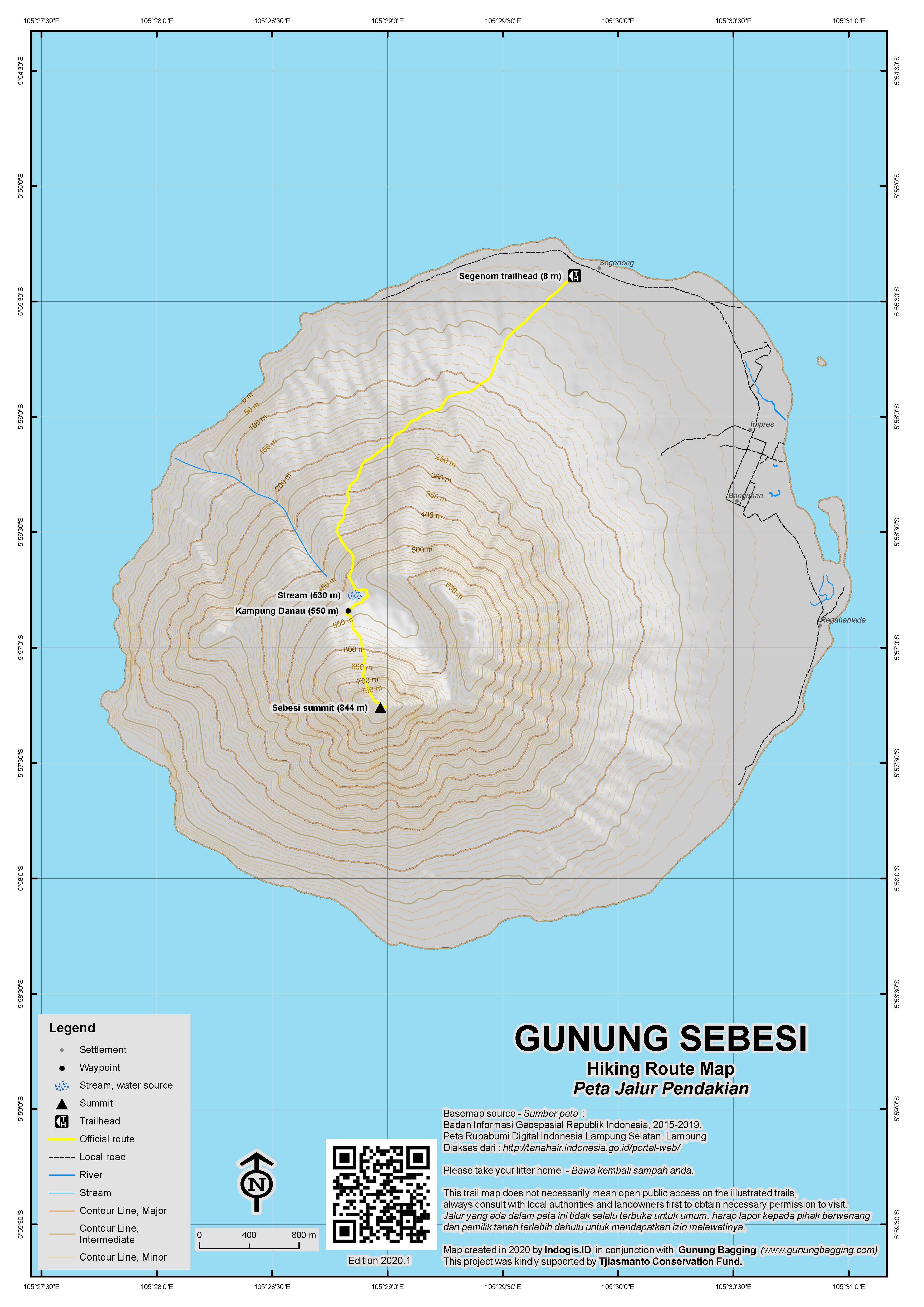
The best starting point for the hike is Kampung Segenom from where it takes just under 3 hours to reach the peak. If walking from the pier itself, add an extra 30-40 minutes each way, but you should be able to arrange an ojek with very little difficulty. Because the starting point is just a handful of metres above sea level, this can be a horrendously hot hike. The best solution is to set off before dawn and descend in the early morning. The gentle trail leads up through coffee plantations and is very well-defined as it leads all the way to Kampung Danau – a small collection of village huts at 550m. Just prior to this village is a small stream – not the purest looking water but certainly a good place to have a splash on your descent! Do take care in this area as there are a large number of trails and it is easy to become lost even with a guide – especially in the dark!
After Kampung Danau, the trail gets a lot steeper and – after rain – a lot muddier. Gloves and long trousers are essential to avoid getting cut on thorns. Eventually you will have reached the top of the island. There are a couple of small openings in the forest – the true high point is crowned with a cement pillar presumably dating back to Dutch days. In February 2011, this actually had to be uncovered so it may have been hidden for a decade or more. It has a metal sign with ‘SEC: TRIANG: No 109’ written on it.
Despite being the highest peak in the Sunda Straits, there is not much of a view from the top due to the height of the trees. What would be one of the finest viewpoints for Krakatau is unfortunately too densely covered with vegetation. If the weather is fine, you might want to consider climbing a tree to see if you can catch a glimpse of the legendary volcano. It is quite amazing to think how affected this island would have been by the 1883 eruption – due to it’s proximity to Krakatau it was not-surprisingly totally devastated. Indeed, it’s hard to find a tree on the island that looks old enough to have survived the catastrophic events of 1883.
It takes about 2 hours to descent the same way and an extra 30 minutes back to the pier. On the way down there are some lovely views over to neighbouring Sebuku island.
Bagging information by Daniel Quinn
Trail Map

For a high quality PDF version of this and other trail maps, please download from our Trail Maps page.
Practicalities
- Getting there: DAMRI bus from Gambir to Bandar Lampung, get off at Kalianda and take an ojek to Canti pier. The public ferry costs just Rp15,000 each way (from Canti 1pm, return from Sebesi 7am). Small boats seating 3 or 4 can be chartered to make the crossing for Rp300,000 which is of great use for returning at a more convenient hour. ALTERNATIVELY a bus/angkot or car to Carita or Anyer and charter a boat (much more expensive).
- Guides and GPS Tracks: Want a PDF version for your phone? Looking for a guide? Need GPS tracks and waypoints? Gunung Sebesi information pack can be downloaded here.
- Trip planning assistance: Would you like Gunung Bagging to personally help you in arranging your whole trip? Please contact us here.
- Permits: Not required but take a photocopy of your passport photo page just incase.
- Water sources: Take sufficient supplies with you. There is a stream at 530m and if really thirsty due to the heat you could as a last resort ask for some drinking water at Kampung Danau.
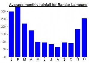
Local Average Monthly Rainfall (mm):

Location
Click on the blue arrow ![]() (top right) to see your current location on the map
(top right) to see your current location on the map
Origins and Meaning
‘Besi’ is Indonesian for ‘iron’. In English we have the saying ‘as hard as iron’, and it would appear that in Indonesian iron also refers to something of great strength. Residents say the island got its name because of its immovable and unbreakable nature. So, the island is ‘as hard as iron’. It certainly survived (relatively speaking) the volcanic eruption which totally destroyed neighbouring Krakatau in 1883.


I just came back from Pulau Sebesi and i had a disappointing Gunung Sebesi climb. I stayed at Pak Hayun Homestay and he offered me one of “his guys” to take me up to Sebesi. It is not only that the “guide” got lost a few times but that he couldn’t take me higher than 590m. He said that it was not possible to reach the summit. Waste of 150.000Rp and time…
be sure to check out my article about Sebesi and Krakatau in this month’s April 2011 edition of hello bali
http://www.hellobalimagazine.com/index.php?option=com_content&view=article&id=281:the-ghosts-of-krakatau-&catid=95:off-shore&Itemid=61. Zac
only in indonesia, hopefully it will beteer as soon as possible 🙂
Just back from Sebesi island. Made it in a regular weekend from Jakarta – just about! Got the DAMRI night bus from Gambir station at 10pm Friday night, reached Merak at just after midnight – total chaos at the moment – today’s Jakarta Globe is reporting a 12km tailback of lorries waiting to make the crossing! Luckily we only had to wait 3 hours before boarding. Once aboard, I clambered to the top of the boat and found a dark place to lie down to get some rest. However the captain starting chatting to me and invited me in to have a look at the steering wheel and the alarms and compass etc etc! We had to wait around in the middle of the Sunda Strait for an additional 90 minutes as there was a queue of ships trying to dock at Bakauheni. We finally disembarked and the DAMRI bus continued its journey towards Bandar Lampung. It always stops at the Rumah Makan Siang Malam just before Kalianda – very tedious when you’ve been sitting around on a boat for hours and hours. Anyway before long I got off the bus at Kalianda and wandered down into the town where I got an ojek down to the delightful Canti pier. As it was only 8.30am I still had well over 4 hours to waste so I went to the warung next door and lay down. At 1pm we set off, after a ship full to the brim of bananas had been unloaded.
The following morning there were some terrific thunderstorms at 3am so we delayed our departure for the hike until 4am. It was a great hike and although the sky was grey I was perhaps spared from the worst of the heat.
To get back to Jakarta, I had to charter a tiny vessel to take me back over to Canti. This was a laugh – there were some huge waves and one of the chaps had to continually scoop out the water – remember to cover your possessions in plastic if you do this! Back in Canti I got an ojek all the way back to Bakauheni port for a bargain Rp 40,000 for what is about 35km. At Bakauheni the fast boat was running so I was back on Java an hour later. The buses from Merak are all pretty bad – stopping at Cilegon, Serang and anywhere on the toll road that people want – more of an angkot than a bus. Though that is nothing compared to the 12km queue of lorries waiting in the opposite direction!
http://www.thejakartaglobe.com/home/12km-traffic-jam-highlights-woes-in-infrastructure/425552
Our bus finally crawled into Jakarta at about 5pm.