
Facts
- Elevation: 2,803 m (9,196 ft)
- Prominence: 1,218 m
- Ribu category:
 Tinggi Sedang
 - Province:
 Jawa Timur (East Java)
 - Coordinates: -8.0627, 114.2620
- Rating:


 (21 votes) Add your rating
 Loading...
 - Eruptions: Ijen 1796, 1817, 1917, 1936, 1952, 1993-94, 1999, 2002
- World Ribus ID: 69139
Photos


Bagging It!
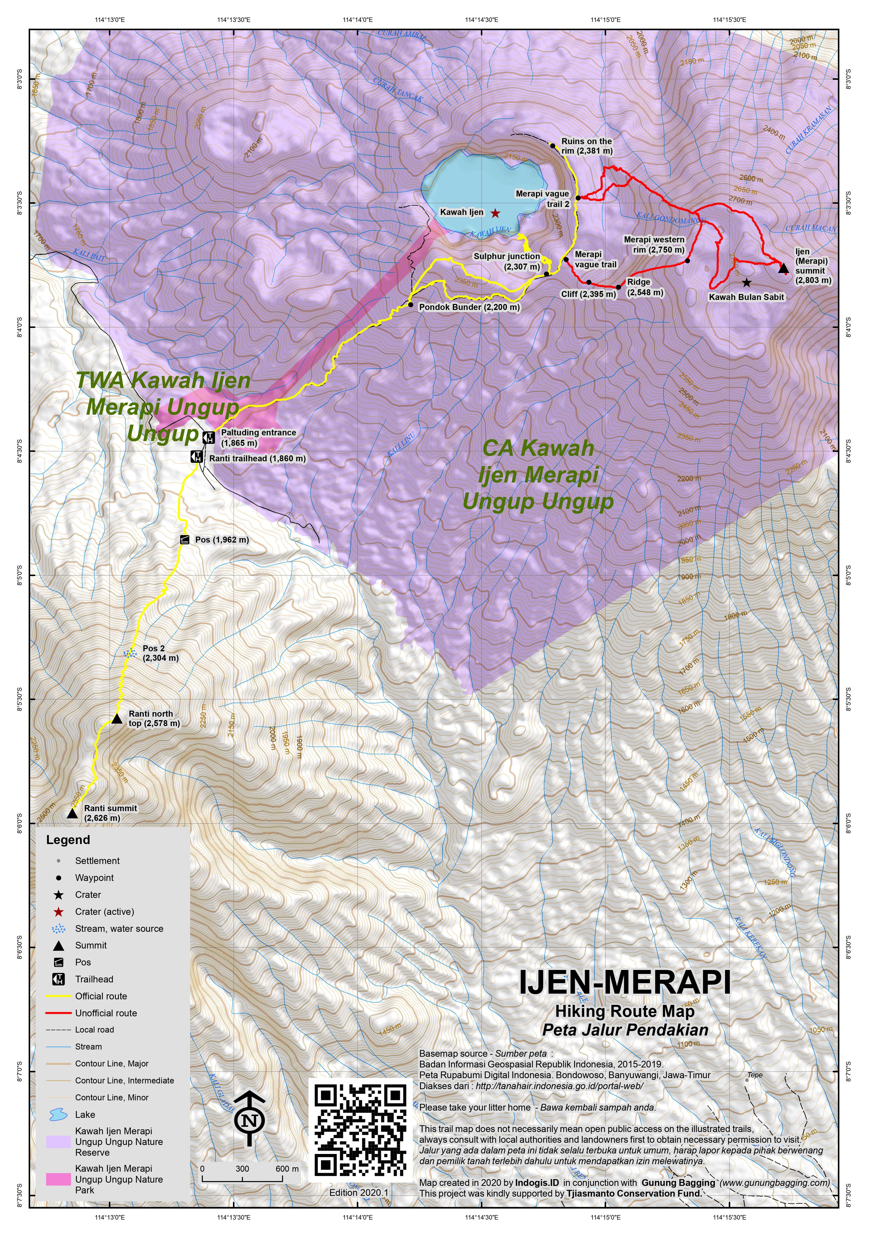
The Merapi-Ijen volcano complex lies within the much larger Ijen caldera on the eastern-most tip of Java overlooking Banyuwangi, the point of departure for the ferry crossing to Bali. The caldera is about 20 kilometres across and famous for its Arabica coffee plantations. Gunung Merapi – not to be confused with Central Java’s volcano of the same name or West Sumatra’s Gunung Marapi (sic) – is the highest point of the caldera complex, on its eastern rim. The Ijen crater lies immediately below, and on the western flank of, Gunung Merapi and contains Java’s largest crater lake renowned for the molten sulphur that exudes from vents in the crater. It is one of East Java’s most visited natural attractions.
Most visitors do not venture beyond the crater, which is fascinating in its own right but now so popular that anyone looking for solitude is not going to find it! But it seems that very few seek to climb Gunung Merapi let alone reach its highest point (‘true summit’). The ranger post at Paltuding (1,865 m) is the start point for both the crater and mountain where permits are obtained and guides available, though technically you need a permit from BKSDA Jawa Timur in Surabaya to visit Merapi (something that ordinary hikers will unfortunately not be granted).
Ijen Crater: Guides are not necessary for the pleasant walk to the crater. A well formed, three-metre wide, track leads two kilometres to Pondok Bunder (2,200 m) where the sulphur porters weight their loads and another kilometre to the crater rim (2,350 m). Most visitors take a break at the saddle on the crater rim (‘viewing point’) to view the sulphur vents and turquoise lake some 300 meters below. Here, you will see the porters carrying their 75-90 kg loads, in two baskets on their shoulders, up the steep crater wall and then a further three kms down hill to the collection point. Most porters make the journey twice a day, though in the last couple of years more and more porters have been using custom-built trolleys to carry their load. These trolleys were thought up by Heinz von Holzen and funded by many including the Swiss government. Whilst it makes life easier for the sulphur collectors, you will also see tourists either unable or simply too lazy to walk up to Kawah Ijen being transported in the trolleys!
You have three options at this point. You can climb to a high point, to the south-west, above the crater rim (2,400 m) for magnificent views; or, continue on around the rim, in an anti-clockwise direction, for even more expansive views of the lake and the larger Ijen caldera beyond. The third option is to take the very steep track down into the crater to the sulphur vents and highly acidic (H2SO4, pH = 0.5) lake. The descent normally takes about 20 minutes but you may spend longer taking photographs of the porters and the surreal surroundings. Give way to porters carrying their heavy loads up the track! Be alert to sulphur fumes emitting from the vents as these can make breathing difficult, even suffocating, especially when the winds changes in your direction. Face masks, dampened with water, can help to protect from the worst of the fumes. Needless to say, don’t even think about swimming in the lake!
Gunung Merapi lies directly above Ijen crater to the east. despite being a large, wild area of great natural beauty, it is currently closed to all but scientific researchers who have permits arranged with the BKSDA. We do not know when or if this unfair situation will end.
There are two possible routes to the summit, one of which is via a ridge rising from the north and clearly visible against the skyline from the eastern side of the crater rim. Continue around the crater rim in an anti-clockwise direction from the ‘viewing point’. After about 2-300 meters, you will pass over a small knoll on the rim. About 20 metres after this knoll, an ill-defined track leads down through scrub into a ravine below and up again onto the summit ridge. Be careful to make a mental note of where the track leads up from the bottom of the ravine (assuming it is visible and not totally overgrown) otherwise you may have to ‘scrub bash’ your way up onto the summit ridge – an exhausting exercise! Once on the summit ridge it is a steady, but steep and not enjoyable climb, to the rim through heavy undergrowth – bracken and burnt/dead trees. Long trousers are advisable.
The summit of Gunung Merapi consists of a now extinct, broken crater with five or so knolls (high rounded hills) around its rim. The old crater consists of several open, flat, sandy areas, alun-alun, that would probably be flooded in the wet season. A pleasant camp could be made on these alun-alun, out of the wind, if dry; otherwise, on the rim by clearing some undergrowth. There is a striking little crescent moon (‘bulan sabit’) of vegetation in one of the dry craters and some local hikers refer to the area as Kawah Bulan Sabit (Crescent Moon Crater).
The ‘true summit’ (2,803 m), one of the five knolls on the rim, lies on the northeastern side overlooking Banyuwangi and Bali and is marked with a large old Dutch triangulation pillar. After emerging onto the rim from the summit ridge, continue in a clockwise direction around the rim – if you want to reach the summit, do not descend into the sandy crater. As the ‘true summit’ is rarely climbed, you may have to bash your way through thick undergrowth. Also, note that the approach to this knoll is quite steep.
The views of Bali’s Gunung Agung and Lombok’s Gunung Rinjani from Java’s most eastern mountain would be fabulous especially at sunrise so a night on the summit would be worthwhile. Peaks to the west include the massifs of Gunung Raung and Argopuro. Gunung Baluran can be seen to the north. Perhaps the most impressive view is the Ijen crater lake 500 metres below best seen from a knoll marked with a small handmade sign (2,775 m) on the western side of the rim looking directly over the lake and the Ijen caldera beyond.
It is possible to reach, and return from, the ‘true summit’ of Gunung Merapi in one long day if you start early and do not spend too much time at Ijen crater on the way. However, it might be advisable to camp a night there and really explore what is such a great area. It seems that the local guides, who mainly take visitors to the Ijen crater, have little knowledge of the route up Gunung Merapi and even less about which of the knolls is the ‘true summit’. In fact, there is really no need for a guide if you can find your way from the Ijen crater rim across the ravine and onto the summit ridge. The rest of the climb – up the summit ridge and around the summit of Gunung Merapi – is quite transparent. If you do hire a guide, make sure that he, at least, knows the track across the ravine. Of course, the ranger post at Paltuding may insist that you be accompanied by a guide and even dissuade/forbid you from the climb if not! If you plan to hire porters to camp on the mountain then you will need to make more detailed arrangements.
Gunung Ranti / Rante
Since at least 2019, a new hiking objective has been on offer in the Ijen area, namely Gunung Ranti (2,626m) which lies just south of Paltuding. Being one of the Ijen caldera’s main peaks, this is a really great viewpoint and the trailhead is just two minutes’ walk from the Kawah Ijen trailhead. It sees far fewer hikers than its too-popular neighbour, but the trail is already quite eroded!
It takes most hikers 2 hours or so to reach the viewpoint at the top and less to descend. If you want to enjoy the sunrise, get started by 3am. The trail leads pretty much straight up, passing the remains of a shelter (1,962m) and getting progressively steeper and more slippery, with small rocks making it hard going at times. A water pipe follows the middle section of trail and at around 2,282m you can usually fill your bottle up if necessary. This is soon followed by the remains of a second shelter (2,304m) seemingly abandoned after the forest fire here in 2019. For the same reason there is not much shade so be sure to take sun cream with you if you burn easily.
The ‘summit’ (2,578m) has a few summit markers (with the rather optimistic height of 2,601m), a pleasant wooden table and the remains of a substantial shelter. There is enough space here for ten tents or more. This spot has excellent views back over the valley to Ijen – which will probably have a sulfurous cloud hanging over it, and the taller Merapi, and eastwards over to Bali’s Gunung Agung.
Perhaps best of all, however, is the view west to the meadow-like plains of the Ijen caldera below, and behind the jagged Gunung Raung, all seen from just one minute away beyond some vegetation. Another jagged peak can be seen from here, much smaller and little-known, lying near Taman Galuh to the left (north) of Gunung Ijen. According to the Bakosurtanal map this is Gunung Ringit (1,983m). It looks like something out of a fantasy film!
Further south, through more vegetation, you will see the true summit of Gunung Ranti (2,626m), lying almost one kilometre away beyond a col. Almost all hikers only go as far as the lower ‘north top’ here at 2,578m and it sounds like the true summit is overgrown and difficult to reach without a machete. However, if you want to avoid the crowds on Ijen, Ranti sounds like a great choice whether you reach the true southern summit or not.
Bagging information compiled by Nick Hughes from information provided by Heinz von Holzen, Nicholas Hughes, Mykhailo Pavliuk and Dan Quinn (updated Aug 2020)
Trail Map
For a high quality PDF version of this and other trail maps, please download from our Trail Maps page.
Practicalities
- Getting there: For domestic flights from or to East Java, such as the airports in Surabaya, Malang and Banyuwangi, we recommend Baolau. Best approached from Banyuwangi. No jeep needed anymore as the road has been resurfaced. It takes one hour from Banyuwangi to Paltuding. There are also now direct flights to Banyuwangi from Jakarta.
- Guides and GPS Tracks: Want a PDF version for your phone? Looking for a guide? Need GPS tracks and waypoints? Gunung Ijen information pack can be downloaded here.
- Trip planning assistance: Would you like Gunung Bagging to personally help you in arranging your whole trip? Please contact us here.
- Permits: Easy for Gunung Ranti and the Kawah Ijen tourist trail, though at peak times you are supposed to book online for the latter. For the highest peak of Gunung Merapi, officially you are supposed to arrange a permit in advance from BKSDA in Surabaya. If you are a regular hiker simply wishing to enjoy the scenery and views you will probably not be given permission. If you are a scientist conducting specific research then it may be easier. Entry ticket for the usual trip to Kawah Ijen now (2020) costs a ridiculous Rp100,000 on weekdays and Rp150,000 at weekends and even if you work in Indonesia, pay tax locally and have a KITAS/KITAP if you are not Indonesian you will have to pay this high rate. Local price about a tenth of the foreigner rate.
- Water sources: None available except a water pipe at around 2,282m on the Gunung Ranti trail – for all others take sufficient supplies with you.
- Accommodation: Try the Booking.com map above or use this link to search for suitable hotels, homestays, resorts and apartments for your trip.
- We recommend Safety Wing as travel insurance for overseas travellers and tourists hiking up to elevations not exceeding 4500 metres.
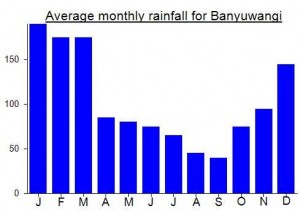
Local Average Monthly Rainfall (mm):
Location
Click on the blue arrow ![]() (top right) to see your current location on the map
(top right) to see your current location on the map
Origins and Meaning
‘Ijen’ is Javanese for ‘alone’ or ‘lonely’. Merapi means ‘mountain of fire’ and from the appearance of the craters it is obvious that Gunung Merapi was a very active volcano in previous centuries.
Good to see Rob W make it to the very top this week….
https://www.peakbagger.com/climber/ascent.aspx?aid=3015753
“First summit reached is higher as far as I can tell, hand level but uncertainty due to deep vegetation. 2nd summit has trig pillar, only 40m further on but tough to reach!”
Reached the true summit of Merapi on July 23, 2023. A few hours of bushwhacking required. Found a better way on the descent to avoid the worst of the bushwhack. Much of the “trail” on NW Ridge is overgrown and there’s no visible path leading down from Ijen’s crater.
Had a very surreal experience in Ijen this time. Firstly, everywhere we drove in the Banyuwangi area, seemingly in every single little village, were huge posters of a local young woman called Ipuk who wants to be Mayor of Banyuwangi. Every single bend in the road and there was Ipuk staring down at us!
I had booked at the Ijen Miners’ Family Homestay a second time, after having had to cancel the first time due to the start of corona. This time we at least tried to find the place but it’s along a bumpy track with unmarked junctions and finally we reached a mosque outside of which was parked a truck, effectively blocking our way forward. So, sorry to Ijen Miners’ Family Homestay, but we decided to get back to the main road at Licin and drive all the way up to Paltuding at the top of the pass where the Ijen and Ranti trailheads are and see if there was any accommodation there.
It was misty but very little traffic on the road. Once in Paltuding we found ourselves above the clouds, with partial views of both Ijen and Ranti. Considering that the place usually sees up to 2000 European tourists stomping like cattle up to the crater lake every single night, it was eerily quiet. Despite now being open to Indonesians, we didn’t see many others in the area.
My objective was a quick sunrise hike up Gunung Ranti on the southern side of the pass and the eccentric Karona Berg homestay seemed the obvious place, being exactly at the start of the trail. The rooms are very basic and it gets cold at night but what a great location. Not sure that there were any other guests as they most probably rely on international tourists, none of whom can enter Indonesia until September 11th, and even then perhaps only Bali.
The next morning I set off with a guide from the homestay at 3am and we were at the ‘top’ in 2 hours. There were 2 or 3 tents there – a much nicer experience than the masses usually stomping around Ijen. The view is indeed superb in clear weather, though when I tried to see a way through to the true peak (further south) the trail disintegrated in an area where hikers clearly go to the toilet. So I decided to just be content with the excelent panorama of Raung, Ijen-Merapi, Agung and so on.
Raung was actually roaring, as its name implies – about every 30 minutes came an explosive sound. I managed to get a couple of photos of a bit of dark grey smoke above the crater. Worryingly, the next day our flight actually flew very close to the crater on the way back to Jakarta. Perhaps there are no current warning for pilots, but perhaps there ought to be given the ‘roaring’! I certainly wouldn’t want to be on a plane suffering like the BA one from KL to Perth back in 1982 that flew over Galunggung just as it erupted yet somehow managed to get the engines going again and make an emergency landing in Jakarta!
Alas our time at Karona Berg ended on a sour note when we received the bill, including a whopping 500,000 for the room which was more like an old shed with a toilet and cold water than a hotel room. I know business is tough right now but this kind of price is, in my view, completely inflated and was not clearly specified when we checked in, perhaps deliberately, as tourists in this region rarely return to the area so what reason is there to worry about negative reviews when there is a steady stream of new ‘customers’? So, despite really wanting to recommend the place as the ideal spot to find a guide for Ranti and even stay for a night, I’d definitely suggest elsewhere!
We hired a car from Armada Timur – 825,000 for 3 days – which was good value and saved an awful lot of transport hassle with Grab / Gojek / taxis / irregular buses. In this part of Java, driving is actually rather pleasant due to lack of ‘macet’.
https://www.thejakartapost.com/multimedia/2019/10/02/carts-for-rent-at-mount-ijen.html
And not a word about what the ‘carts’ were originally designed for. Or by whom.
Then again, is it worse to use them to cart sulphur down for a lesser fee or lazy tourists (elderly and disabled excepted) for a higher fee?
I finally made the true summit of Ijen-Merapi, but never again. I came here back in July hoping to bag the summit but there was strong wind and cloud so I postponed it to another time.
Fast forward to October and the weather was brilliant so off I went. I made the crater rim by first light and was into the scrub at 430am (sunrise 5.05am). The first part is horrendous. There is no trail at all and you have to make your own. My first regret was not wearing long pants. My legs were eaten alive by the dead sticks. I reached the ridge line and headed up a relatively good path. You can clearly see the path by using google satellite so if you want to go you have to find your own way to the ridge then follow the trail from google satellite.
I didn’t realise that the ridge was so steep and that it went on for so long. I did see pictures of the craters online and thought they were at different levels but this isn’t the case. The ridge pops out about 2700m and then its just left around the craters until you reach the summit. If it weren’t for the “triangulasi” pillar at the top you would never even know that you’ve made it to the real summit.
There has been a massive fire that has taken out all the trees and bushes at the top. Matthias, in the comments below claimed 5 hours return from Ijen crater but I was up and back in 2.5 hours with an explore of the craters as well. Seems that the fire may have sped up the trip as you don’t have to bush bash at all once you get onto the ridge.
It’s a pretty interesting place up there and would be really cool to camp up there if one had the time. Now is the time to go because the fire has made the trail much better.
Side note: I also climbed Gunung Ranti, literally across the road from Ijen car park. The trail has been open since last year and is really nice, but sandy to the top. The “true” summit is in the trees and I tried to go there but made it half way before deciding enough was enough. The clearing at 2570m has some insane views over to Ijen Crater and Raung. It’s just 3km and 700m up one way so its a great little side trip if you have the time and energy.
I just went to Ijen and what a gong show. I visited 4 years ago and I can only say it’s worse than ever.
I met Heinz in 2015 and he had gotten the Swiss government to donate money towards the sulphur porters trolleys. To see them now with cushioned seats so lazy tourists can get transported is ridiculous. The porters even say ‘taksi’ so they aren’t trolleys for sulphur but taxis for lazy tourists.
I didn’t even bother to go into the crater. Instead I left the base at 330am and was up in around 50 mins. I walked very slow but took no breaks. Once at the top there were hundreds of lights (the guy in the ticket booth said more than 1000 people went up already). So instead of congregate there I went counter clockwise all the way around until as far as I could go.
I actually tried to circumnavigate the kawah but only made it about 3/4 of the way around. There is a big rocky outcrop on the far side that I made it to before it got too dangerous. The ridge is pretty sharp and the rock quality very bad and slippery. If you had a rope and a friend it could be safer but still gnarly. You could also descend a bit and then come back up but youd need some time.
By 6am the rain was coming so I turned around and headed back. From the point where you descend to the crater to the entry gate took 20 mins. Total distance was 12km and my GPS said total gain was 775m.
It is a really cool place if you can explore the crater edges more but the rain stopped me from that. The other annoying thing is that as a foreigner we pay 100k and a local just 5k. That’s 20x the price, absolutely insane!
The cloud obscured the view to marapi but I couldn’t see any evidence of a trail. Looks like a Bush bash to the ridge. I looked on Google maps and some indonesian kids have added photos of themselves at the sandy crater just below the summit so there is definitely a way up there. When the weather is better I’ll give it a go but for now it’s onto Bali.
Sunday 9 June:
An impromptu walk with some Indonesian friends, it was their first time visiting the crater as well, we had actually been relaxing at the pool, when one of them suggested we head off that evening to see the blue fire.
Left Surabaya at 1730hrs, a slow drive to the start point took 9 hours. We began walking from Camping ground Gunung Ijen at 0300hrs, we arrived at the blue fire view point at 0415hrs, sunrise was at 0531hrs and back at the start point by 0715hrs.
Arrival; At the bottom of the track, there are plenty of hawkers peddling merchandise, gas masks / hats etc, having read previous reports we didn’t purchase a gas mask using instead deciding if needed we would improvise one from a motorcycle facemask. There are also plenty of places to eat, drink and if you feel the need buy gifts.
Being from the UK didn’t need a hat or gloves, even at 0300hrs it was still +23 Deg C. A head torch was needed for the walk up, and once at the crater a coat / fleece was nice to have as you have been sweating and then stand around for a while waiting for sunrise.
Cost; Tourists (even those of us who have those of working here are tourists) pay 100,00 IDR for a weekday visit and 150,000 IDR for a weekend visit. We also had a local guide attach himself to our group which at first we didn’t think we would need, but he was a wonderful source of knowledge and entertainment as well as being a good motivator for those less motivated to reach the top, and an amazing photographer who helped get the best group shots and prevented the need for the obligatory selfies.
The walk up; (approx 1 hour 15 minutes) As mentioned in previous comments the walk up is relatively easy as the track is wide and smooth, although be warned (weekend) the number of people heading up makes the going slow, especially as the incline increases if you are not prepared to zig zag and move through the crowd I imagine it can take a while longer. Plenty of people resting on the route up, and some taking the ‘Taxis’, you have to feel sorry for those taxi drivers as some of the fares couldn’t have been easy!
Blue fire view point; Once at the view point, they have prevented tourists from going down to the lake (there are signs right at the bottom stating this, which we missed), therefore, the view of blue fire is a little disappointing (almost not visible at all). However, moving further up and around the crater to catch the sunrise is well worth it for both the amazing view towards the coast and the sun rising majestically as well as the increasing beautiful view of the blue lake and the billowing sulphur fumes.
With our improvised face masks, we could still smell the sulphur and have no idea if we prevent any ‘chemicals’ from entering the lungs, there were plenty of people without any protection at all and they didn’t seem to be suffering any effects whatsoever.
You are not going to be alone, there were 100s if not 1000s of people there, most seemed to have spent the night, at least from the number of fires that were burning it appeared so.
The walk down; Approx 55 minutes is uneventful apart from the increased number of walkers using the ‘Taxis’, the taxi drivers call ahead and you politely move aside for them to get their fare down the path. The walk down again could be slow as there are 100s of people all heading down at the same time, be prepared to zig zag again to keep moving ahead.
Resting; There are adequate places to stop and rest should the need take you, and on the way down there was even a little warung open selling coffee and pot noodles, of which plenty of people were taking the opportunity to drink, eat and rest. There are also a few people selling little sulphur trinkets and we love Ijen gifts.
According to Suunto; Bottom – Top – Bottom again was 4 hours 12 minutes, total distance 9.65 kilometres, ascent time 1 hours 24 minutes, descent time 55 minutes. Ascent totalling 503m.
Afterwards we stayed at a homestay approx 6 km from the bottom of the track (Hotel Catim) for a few hours of sleep before heading back to Surabaya departing at 1145hrs and arriving back in Surabaya at 1800hrs.
Paul
Pengen sekali merasakan keindahan alam dari puncak ijen itu, masih belum kesampaian e.
Visited Ijen today from Banyuwangi. The road up is in decent condition, but I dunno if I’d be keen on riding it myself at 2am in order to save a relatively little bit of money—it is a bit ropey in places.
The hiking trail up is in excellent nick and think is only a matter of time till motorbikes are running all the way to the rim. (We saw one at the rest station about 45 minutes from the rim). Plenty of porters hailing as taxis, but saw none being taken up but a few going down.
Started walking at 2am so as to see the “blue fire” which was well impressive, but the trail down into the crater is quiet dangerous—not so much because of the trail condition (which is rough but ok), but rather the idiots on it who are hopping and jumping all over the place, dislodging rocks and so on. Really concerning. There were probably somewhere between 200 and 300 people there for dawn at the rim and at least half of them were kicking around in the crater before that between 4 and 5 am and it was a veritable shit show.
As mentioned in other reports, the sulphur fumes can be pretty overpowering—I would strongly recommend getting your own mask rather than using a supplied one as the quality is very variable (mine broke twice) along with protective eyewear. Where the pipes empty out, kinda at the base of the blue flame, where the fumes are absolutely at their worst, there was perhaps 30 people juggling for position for selfies and so on—then the cloud of fumes would blow over and everyone would start gagging and keeping their eyes closed. Because of the groups of people, it was difficult to extricate yourself. It was both frustrating and extremely uncomfortable.
This area is a serious accident waiting to happen.
Cost wise, long story short, we initially chartered a car to take us from Banyuwangi to Ijen then on to Bondowoso for 800,000 for the two of us. The driver then showed up at 9pm on the evening we wanted to go and said he now wanted 1,300,000. We sent him packing and didn’t climb that night.
The next day we just signed onto a tour, which cost 350,000 rupiah all in. Included car transport (pick up and drop off) admission (100,000 on weekdays, 150,000 on weekends for foreigners (no discount for Kitas), 5,000, 7,500 for Indonesians), water, guide and mask. Others in the group paid 300,000, so some wiggle room, but given admission is 100K, less than 200k is perhaps ambitious IMO. We had a group of 12 with one guide. As mentioned above a guide is not needed to the rim, but good idea if heading into the crater.
When back at the Ijen carpark, we asked after ojeks to Bondowoso, and was quoted 300,000 rupiah LOL needless to say we went back to Banyuwangi.
I wouldn’t go into the crater again.
The views from the rim are spectacular and I really enjoyed the walk out as well as we had terrific weather.
Cheers
I climbed Merapi this weekend. According to my GPS it is 2811 m high. There is a certain error margin, but the difference of eight meters is too much. The highest point is correctly shown in the Google Earth image. I took the “trail” until the rim of Kawah Bulan Sabit crossing two sandy areas. There I turned left, went down to another sandy area and climbed the highest peak. Curiously, the highest peak is the only forested one. It is quite easy to identify.
The most difficult part of the trail is the starting from the Ijen rim. There are no trails in the small valley between Ijen rim and the cone of Merapi. Once on the right ridge of Merapi there is quite a clear trail until getting to the first “summit”. From there the trail is faint, but at least in parts visible. From the summit you have a nice view to the East, to Banyuwangi and Bali, but the much better view is the one from the ascent route towards Ijen and Raung.
lt is obvious that there are some people who go to Kawah Bulan Sabit because there is something like a trail. But, as written in the comments before, the summit seems to be visited nearly never. I could not see any trace of any human visitor.
Merapi seems to be very close to the rim of Ijen, but actually it is quite a hard work to climb Merapi, especially because of the missing trail and the dense vegetation in some parts of the route. Calculate with five hours for the round trip from Ijen to Merapi and back.
I had 5 mountains planned for my summer break but only managed to reach the summit of 3 of them. The two that I didn’t manage to bag were this one and Gunung Niut in West Kalimantan. The reason was the same for both of them…. local authorities are closing areas to hikers – basically anyone not conducting scientific research. Niut and Merapi are both in conservation areas. For Niut I wrote a proposal including risk assessment and a map and I wish I hadn’t bothered wasting my time as I was refused permission by BKSDA Kalimantan Timur. So for Ijen-Merapi I presumed I would get the same response.
I did however have a local contact who might be able to get permission locally to hike up Merapi so I thought I would head there to assess the situation and see if things had improved since my last visit several years ago. Ijen itself is a lovely spot, but the atmosphere is somewhat ruined by the sheer number of tourists trudging up in time for dawn…. up to 2000 a day during the peak season according to locals.
Merapi, of course, sees very, very few visitors for obvious reasons…. from one extreme to the other and over the space of just over 1 kilometre!
However, all was not well, as my contact kept responding to my text messages about the proposed hike with short comments referring to heavy rain! In retrospect I now realise that this was his rather unusual way of saying he didn’t want or simply couldn’t take us to Merapi.
When we met, he was clearly nervous about hiking to Merapi so presumably permission was not possible to get locally at the Kawah Ijen office, so our hike was aborted and we just had a look round Kawah Ijen itself. Very disappointing but quite beautiful in the early morning light and when the hordes of tourists have started to stomp back down the trail (or misuse the new trolleys by paying sulphur porters to push them back down to Paltuding).
I recommend staying near Karang Asem train station the night before or after. We stayed at Koko Homestay at the far end… rooms downstairs with a view of a plantation. Only Rp100.000 or so. No Indomaret for 1km but enough local shops for basic meals and supplies. A Go Car to Kawah Ijen from Banyuwangi is only Rp145,000 but as most people start the hike at 1 or 2 am you may be lucky to find a driver using an App such as that. As we wanted extra time to take photos and explore, instead of joining other tourists for Rp100,000 per person including transport, we had to get our own car and driver…. easy to find but not cheap at Rp600,000 for what is an hour-long journey and back. You can hire motorbikes cheaply so that might be a better option if you want flexibility. You certainly don’t need a jeep anymore as the road from Banyuwangi up to Ijen pretty good now.
Our driver was typically inept, arriving 20 minutes late and then doing an 8km detour to fill up with fuel (they often seem incapable of thinking more than 30 minutes into the future)!
While in the area, I recommend asking if there are any gandrung music performances (such as at weddings) as this local traditional music is brilliant – earthy, rustic and intoxicating.
There are some great views of Merapi from near Banyuwangi Baru station…. also known as Ketapang station. It’s a fair distance north of the town centre and near the harbour where you take the ferry to Bali. It is also the final stop on the railway network in Java. It’s a shame there isn’t a route up to Merapi from this side…. from sea level up to 2,800 – would be quite a hike, and you would be able to avoid the hundreds of tourists at Ijen.
The Kedai cafe just a 2 minute stroll from the station opens at 8am and does a great breakfast – recommended.
There is now a good road from Banyuwangi all the way to the Ijen entrance. Banyuwangi’s bemos (lin) have now practically disappeared, though, as everyone owns a motorbike. The quickest way to Ijen is to take a taxi from the airport to the village of Licin, and an ojek from there.
Foreign visitors holding a KTP Asing can take advantage of the Rp 5000 local fee; otherwise, the fee is Rp 100,000 for non-Indonesians.
Would it be advisable to climb the Merapi summit at night? Needed some advice as I plan to catch the sunrise from the Merapi summit when I head there.
Will start 26th December at around midnight. Will take it nice and slow, enjoying the blue fire as we climb up. Have decent experience climbing the ribus on Java so I’m thinking of doing it without a guide. We are a group of around 5 people. Now I know we can do the Ijen crater without a guide. But what I’m doubtful about is the merapi summit at night, without a guide.. Is this advisable?
Please let me know here or on my email gtdhanushexport@outlook.com
I would really appreciate any help from all you kind gunung baggers out there.
Thank you, and cheers!
I travelled to Ijen Crater only, it is one the unique experience to see the Sulphur coming out from Vents.
It is also admirable to see the life of miners. I have some photos on my blog along with the GPS track.
http://www.wanderingandwondering.com/2013/02/travel-diary-ijen-crater-is-dangerously.html
A few notes sent in by Carl Bernd Kaehlig…
“Going anti-clockwise the crater rim and down to the dam containing/controlling the crater lake is not possible anymore due to a rockslide.This is unconfirmed information from our guides.And true enough we saw a rockslide on that side into the lake!
Actually the walk clockwise around the rim was probably the more fascinating one.From the starting point where the trail hits the crater rim you go up to the highest point of the rim so it seems and then it is a very steep climb down the slope.One part was for most so tricky that they went down on their bottoms and slowly moved down.Close to the bottom of this peek,there is a clearly visible junction.Turn left and it takes you back to the middle station where the sulphur is weighed.Turn right and after having crossed a couple of small bridges you come to a platform,apparently the foundation of a building in the old days.Near this foundation there is a concrete staircase to the dam.
By the way it is not fluid sulphur that comes down the clay pipes.Sulphuric gases come down the pipes and in such a way the gases cool down and are able to condensate so I think.For an example of fluid sulphur see the cover photo of Volcanoes of Indonesia.
Trust my little addition is of assistance.
Best regards,
Carl”
A bit of much-needed info from one of the very few people who have actually reached the true summit of Ijen-Merapi, Myhailo Pavliuk…. (see also the Google Earth map in the photo gallery)
“About Ijen-Merapi. When I arrived to the first summit I did not descend and then go up to the craters until “horse shoe”, I took left side ie clockwise to the summit and just followed the ridge wading through the bushes. Bushes are very thick at times, but the distance to the summit is only 1 km so after 3 hours slow moving in went to the foot of the summit hill, its was grassy and less dense thus not much overgrown. It was at night about 2 am. Myself still surprised how i managed to reach the summit by myself at night without GPS nor map! I spend a night on summit and next day descended to the lowest point on the rim dividing two of craters. I suppose that if using crater to crater way to the summit ie anticlockwise one the final section from “bulan sabit” is looks somewhat dubious as too lush vegetation predominates.
Best regards,
Mykhail “
Along with a couple of photos to be published on the site in due course, the following message arrived from Heinz von Holzen last week regarding his successful bag of Ijen-Merapi’s bushy summit last month….
“This shots I took yesterday around 8 am from the absolute summit of Merapi. Only just 20 meters higher as the spot where people sometimes go. Not really hard to get there. it just takes time. Lots of rough bushes and plenty of thick scrub. It took us 1 hour and 40 minutes to get there. You do not need a porter to assist you hacking as you can make your way through on your own.
Please note that last year perhaps only 10 people hiked up to Merapi and as such the entire trek virtually does not exist. Even with our friend Rudi a Sulphur Porter we had great difficulties finding our way through the thick bushes at the bottom”
After Bromo I and the old French couple were then driven by the Hotel Helios jeep driver to Kawah Ijen. It was early morning of October 30. In retrospect this was one of the most excruciatingly exhausting drives I’ve taken. First of all, the jeep’s AC was busted so it was no match for the 35°C afternoon heat that day. Secondly, that drive dragged on forever, passing through Probolinggo and Situbondo on the northern coast of Java, and then several hours on endless fields and mountain roads.
We turned towards the Ijen plateau in the town of Wonorejo, which is on the Bondowoso-Situbondo road. This bit was initially on paved road that passed through vast corn and rice fields. The road then gradually became rougher as we climbed towards the mountains. I was sleeping the entire time but was jolted awake when I heard a commotion inside our jeep.
Our driver, who by then had not slept since the previous night, was visibly exhausted. His driving skills and wakefulness were suddenly tested in one split second when we encountered roadworks on the mountain road and the road blocked by oncoming traffic. I opened my eyes just as our driver was trying to reverse and maneuver to stop our jeep from sliding uncontrollably backwards on the gravel road. Our jeep kept on sliding despite his efforts and we ended up perched incongruously on the side with the right rear wheel embedded in a ditch. Only the bushes prevented our jeep from rolling off the cliff. The French woman suddenly screamed “descendre! descendre!” and that was my cue to get my backside off that seat and jump onto the road.
So there we were, stuck on a mountain road with our jeep precariously hanging by three wheels. Our driver tried to step on the gas to force the jeep to drive off the ditch but that was fruitless. Road workers soon congregated around our jeep and there was a tremendous babble in Indonesian around us. The Frenchies and I got our bags out the jeep quickly as it really seemed as if it was going to roll off into jeep purgatory, i.e. down the cliff. Our driver kept on trying to force it, some guys even stood on the left side of the jeep to provide counterbalance. All this only made the jeep slide deeper into the slope.
I and the French lade by that time were already contemplating the long walk back to civilization or begging for a ride back. Will we starve? Could we subsist just on coffee beans? Some smart worker then brought cable and attached it to the front. Everyone then lined up and grabbed the cable to drag the jeep off its perch. There was a moment there when manpower seemed as if it were about to win over machine and rock but that effort too was in vain. The Frenchies and I looked at each other and we sensed impending doom. Zout, c’est un cauchemar!
Finally the head honcho suggested that the tractor be brought over. He kept on motioning towards me and making the “give me money” sign. Wait a minute, why me?! I then protested in half Indonesian, half Inggris, making him understand that I’m just a hapless passenger. The million rupiah that I paid for this Bromo-Ijen trip then seemed a million too much.
The tractor made short shrift of our dangling predicament. The Frenchies and I thanked our stars. We will not starve! We don’t have to survive on coffee beans! It took seven hours for us to reach our destination. We arrived at the Catimor Homestay in the town of Blawan around sundown. I was too whacked out to complain about the hard mattress, the rotting bathroom door, mosquitoes and non-flushing toilet in my room. Apparently this homestay is also owned by the Helios Hotel people according to its website. They boast of their Lonely Planet recommendation. I have a thing or two to say about that.
Again it was an early morning start the next day: 4 am. The only consolation was that we had a full night’s sleep beforehand. Our driver too looked rested that morning. I realized then that that was crucial to our survival. You don’t want a driver dozing off on the wheel!
We arrived at the Paltuding post after 1.5 hr driving through coffee fields. Our driver’s laconic instruction was: “follow path for 3 km”. Ok then, off we went. What he failed to mention was that these are three kilometers up a very steep and ashy and dusty trail. More work. So what’s new in Indonesia?
So there it was finally, Kawah Ijen. Just like Bromo the previous morning, all my recriminations and doubts about the entire expedition melted away as I caught sight of that steaming crater. We were prevented from walking down the path towards the sulfur mine at the water’s edge by some security guy. We only had about an hour by the crater before we had to leave so I had no opportunity to look for or attempt the summit. Even after reading Heinz’s and Dan’s description above and thinking about the crater in retrospect, I have no idea where the path to the summit is. The walk back towards Paltuding with Gunung Raung and Gunung Merapi clearly visible in the morning sun was lovely.
We rested in Paltuding before our long journey back. We dropped off the Frenchies for their onward drive to Bali. The thought of another seven hours in that jeep with our driver was a frightful grisly notion. I asked him if we had to drive through the same mountain road as yesterday. His ‘yes’ turned knots in my stomach. Baby Jesus, please send angels to guide his hand and help me survive the day!
I was wide awake the entire time so I didn’t miss a thing. We did pass through the same road, the roadwords and the workers were still there, but we coasted beautifully. It was when we were down from the mountain and reached the first town on level ground did trouble start again. Just my amazing luck! Our driver stopped at some rickety car repair shop by the side of the road without saying a word to me. I quickly gathered that the brakes were loose. Then came two excruciating hours waiting for a couple of mechanics to manually fix the brakes on three wheels. These two days were a combination of highs and lows: fantastic experience with volcanoes and then distressing experience with jeeps and roads and drivers.
I arrived in Malang after eight hours. Never go on the Helios Hotel tours. Their jeep is junk. I only survived because baby Jesus was on my side. 🙂
Is it possible to visit the crater lake on my own without a guide using public transportation?
Kawah Ijen is closed for visitors at the moment. Sulfur mining has also been interrupted, due to high activity. There is a possibility that Merapi Timur might also be closed. This information I received from my tour organizerfor a tour next year. So, better double-check before you go there.
Best
Wolfgang
I just received the email below, which may be of use for anyone thinking of climbing Ijen-Merapi this year. Because of how long iot takes to get to from Jakarta I’m not sure I’ll have enough time this year but it’ll be on the schedule for 2012 for sure.
Dear Daniel Quinn,
Salam kenal,
My name in Aan , I found gunungbagging.com on browsing and interestingly to say it covers gunungbagging.com/ijen/
It is interesting to know
that you are a climbing lover and had climbed Ijen-Merapi in July 2010. I’m a
friend of Imam Ijen who manage his website
(http://imamijen.wordpress.com) to publish his willingness to arrange
tourist trip especially in Kawah Ijen and Banyuwangi in general.
Imam is well-known as a sulfur miner and an occasional guide to Ijen,live in Pakel village-Banyuwangi, he knows the areal very well and everyone working in the volcano (including Pak Im). This season, he
initiate to focus in serving travelers going to Ijen and to make a relation with future travelers to Ijen .
Climbing to Ijen-Merapi is worthy trip for hiking enthusiasts, kind of taking a 2-in-1 package trip. The last time he assisted
visitor climbing to Ijen-Merapi in 2010. Imam has good character and
can work cooperatively with. We’ve heard that accessing to Merapi
sometimes requires permit pass and the cost requirement is unclear.
According to the Chef-Ranger the pass is required since we’re
accessing the conservation areal and to know the objective of entering to the site. However, this permit can be made locally via the Chef-Ranger
Safari, we have close relation with him, and the man is
understandable. I’m sure this would no more tipping case happend to the
on-duty ranger at Post Paltuding and I hope there will be more the Ribu enthusiats come here in the future
Before I tell you further about us, let me know that this introduction
letter will suit with your project . Or you may forward this to the next climber to Ijen Merapi. Thank you.
You can call me at: 085236352909
Salam,
Aan
http://imamijen.wordpress.com
facebook.com/imam.ijen
Here are some amazing photos of sulphur mining at Kawah Ijen at night…
http://www.boston.com/bigpicture/2010/12/kawah_ijen_by_night.html
For pedantic baggers out there (of which I admit to being one) according to Wolfgang Piecha, one of the Java Lava trips certainly got further east toward the true summit than both my own and Heinz and Roman’s trips did. This was probably in 2006 when perhaps the vegetation was a little less dense that it is now. They weren’t specifically looking out for the highest point so they may or may not have ‘bagged’ it. They did enjoy the ‘view on the straits and Bali’ and had a good look at the horseshoe shaped ‘island’ in the more eastern crater.
as an Indonesian, I’m ashamed of bribery exist in Ijen. corruption seems to have ingrained and become part of Indonesian culture, culture of corruption. shame! shame! shame!
Made an attempt on Ijen-Merapi today. Some great views but overall a rather disappointing experience unfortunately due to a mixture of all the usual problems – excessively expensive transport, terrible roads, having to pay ‘uang rokok’ for permission to climb a hill and then the ‘puncak’ not being the actual ‘puncak’. I got a jeep from Banyuwangi which was a rather steep 700,000 for 12 hours rental with driver (my fault for travelling alone I suppose – hopefully enough time to get to the summit and back) because there is seemingly no other transport available from the Banyuwangi side. The jeep proved totally essential as although there are plenty of signs for Kawah Ijen the road up from Banyuwangi is not passable by ordinary vehicles on the higher sections – that’s why most visitors head to Ijen from the north though why local authorities haven’t done something about the condition of the road is a mystery given that it is one of East Java’s main tourist attractions. The warungs at Paltuding were full of tourists heading up or back down from dawn at Ijen.
I had been advised to ask for a chap named Pak Im who is supposedly the main person who knows about Ijen-Merapi – a mountain which despite being only 400 metres higher than the Ijen rim itself is hardly ever climbed by anyone and is wrongly considered a major expedition. At first he declined to help me reach the top as he claimed you would have to set off at 5am to climb Merapi and come back in one day. After a week of bizarre and ridiculous reasons given for not being able to climb various other peaks in East Java (including ‘magic in the area’ for Gunung Tarub/Lamongan) this seemed fairly normal. I trotted over to the office to enquire about someone else who might be able to assist. My request to climb Merapi was greeted with a great deal of shock. I was told it wasn’t possible, that I needed to have a special permit from Surabaya (several hundred km away). In the end it was agreed that if I took full responsibility for any accidents enroute then if I paid 200,000 ‘admin’ fee (to keep the guys in the office with enough cigarettes for the next week) plus 300,000 guide fee then it would be ok. It’s amazing but rather depressing what a few bank notes can do. Pak Im suddenly re-appeared and we set off.
Seeing the sulphur collectors coming down the Ijen trail with their heavy loads is a surreal and humbling sight – a very tough job indeed. We were at Ijen crater itself in just over an hour and the lake shone a brilliant blue in the morning sunlight and there were some excellent views west to Gunung Raung. From the rim we turned right through dense foliage and headed up a bracken-covered ridge of Gunung Ijen-Merapi. The path is faint and we needed a machete – this was the first trip up Ijen-Merapi by anyone for well over a year! Views down to Ijen lake are superb at this section but watch out for occasional razor-sharp grass. The drop to the left is also very steep so be extra careful. Finally the rim of Merapi is reached (we did it in just 3 hours) and you look down over the north-western sandy crater (there is another one further east with a horse-shoe shaped clump of foliage in the middle). This point we had reached (approx 2,777m) was, according to my guide, the ‘puncak’ and there was indeed a small sign – allegedly made by volcanologists a few years ago. However it was obvious that the forested ridge to the north of the eastern crater was higher (2,803m according to the Bako map) and I tried to convince the guide to keep on going to reach the true summit. He declined, saying he had never been there and never heard of anyone going there. I’m pretty sure Java Lava got to the true summit in 2006 so I told him to wait for me while I descending into the dry sandy crater and tried to bash my way up the other side and onto the ridge higher ridge above the horse-shoe crater. The first sandy crater itself was a great place to walk in – on the world’s most densely-populated island you can still find some remarkably wild areas. Unfortunately the vegetation – including Javanese Edelweiss – was just too thick to get up to the ridge between the two main sandy craters and follow it along to the highest point of the ridge. It reminded me of Papandayan where the highest point of the mountain massif is just too thickly-vegetated to be reached. It was at least another 400 metres distance of thick and spiky bush so I had to retreat and we were back down at the Ijen crater in just over an hour.
Despite the short distance of the hike, this one requires more than one day at the moment because of the terrain. It’s a hike of tremendous potential and a real shame that more local people haven’t thought of climbing this hill. It’s the last huge mountain before the Bali strait so views east to Bali are incredible. Why have so few hikers shown any initiative in this regard? It’s also a great shame that any other hikers wishing to climb it will – for the moment – have to pay bribe money at the office in order to try to do it. In my eperiences so far, it would appear that Indonesian tourist attractions and national parks seem more concerned with keeping people out or deflating their plans or simply pocketing whatever cash they can extract from Indonesians and non-Indonesians alike rather than enabling and assisting access – here’s hoping things will change before too long. It wouldn’t take a lot of work to keep the route open and actually allow people to explore the area and perhaps put up a sign or two. I’m sure it would be a very popular route once people began to know about it – many of the ‘turis’ who wander up to Ijen every morning must wonder what is it the top of the bigger neighbouring peak. That hikers supposedly need permission from Surabaya to hike up this interesting mountain highlights the fact that serious problems with access to the natural environment remain for all hikers in Indonesia.