
Facts
- Elevation: 1,657 m (5,436 ft)
- Prominence: 1,494 m
- Ribu category:
 Kurang Tinggi
 - Region:
 Peninsular Malaysia
 - Malaysian state: Perak
- Range: Banjaran Bintang
- Coordinates: 4.6821, 100.8072
- Rating:

 (4 votes) Add your rating
 Loading...
 - World Ribus ID: 68541
Photos
")
")
")
")
")
")
")
")
")
")
")
")
")
")
")
")
")
")
")
")
")
")
")
")
")
")
")
")
")
")
")
")
")
")
")
")
")
")
")
")
")
")
")
")
")
")
")
")
")
")
")
")
")
")
")
")
")
")
")
")
")
")
")
Bagging It!
Not to be confused with the higher and more frequented (but far less prominent) peak near Gunung Yong Yap and Tok Nenek, this mountain is the highest point of a huge range stretching over twenty kilometres from Taiping in the north to Beruas in the south. It is famous for its many leeches, so leech socks are definitely recommended!
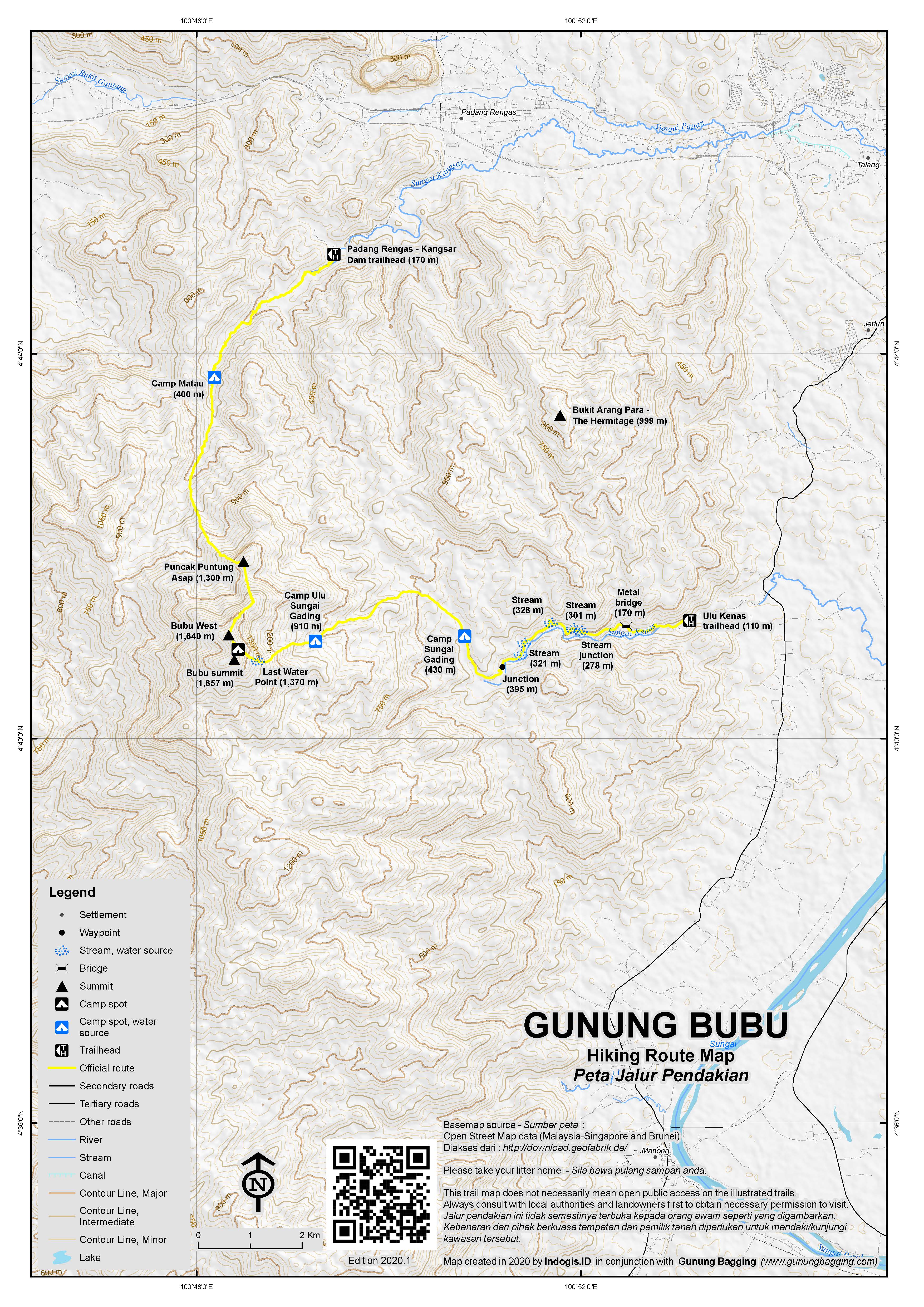
There are two trailheads – a more popular one from the east at Kem Bina Negara Ulu Kenas around 15km from Kuala Kangsar, and an infrequently-used trail in from the north near Padang Rengas. The former can be done in 2 days and 1 night whereas the latter is likely to require either 2 long, full days or more usually 3 days and 2 nights. Super-fast and extra-fit hikers might be able to reach the peak as a dayhike from Ulu Kenas (estimated 12-14 hours) if they set off at first light and have head torches for the descent.
The word ‘bubu’ means fish trap and the mountain is apparently so named because it resembles the shape of a traditional fish trap from certain angles. One of the best views of the mountain range is from the train between Padang Rengas and Taiping.
The main trailhead and parking area at Ulu Kenas (110m) is a very pleasant spot which is popular with locals at the weekends. There are chalets and a waterfall near the Eco Park and a toilet block for washing and getting changed before and after the hike. This is only about a 20 minute drive from Kuala Kangsar, which is notable for being home to Malaysia’s oldest rubber tree, planted in 1877.
As the hike is not especially popular, there are few signs on the trail so a GPS and/or experienced local guide is very much recommended. At first, the trail follows a wide vehicle track past some hydro electric project compounds with an electricity cable running above the track. After a metal bridge, the cable stops and the trail gets slightly narrower and less flat. Take the next left. After about 45 minutes in total you will reach a point in the track next to a tiny stream where there is a side trail going off into the forest on the right. This is an important – and currently unmarked – junction (278m). It is also a great spot for seeing hornbills.
Once on the narrow trail, expect a bit more overgrown tree branches to deal with, as it leads gently into deeper forest, with the river down on the left. There are several minor stream crossings and a rather pleasant little waterfall (321m). Another important junction (395m) follows after several more minor stream crossings and about 30 minutes total from the wide track, with straight ahead being a fishing path leading to the river. You need a right here, and once again it is currently unmarked!
After a total of around 2 hours and 30 minutes (or 3 hours including a few short rests), you will be at the river crossing at Camp Sungai Gading (Ivory River Camp – although written Sungai Ganding on the colonial-era map) with an elevation of around 430m. The crossing may require you to wade across and after heavy rain it could be as deep as knee or even waist height. On the other side of the river is a small flat camping area and to the left, partially hidden in the trees is an old white warning sign.
Beyond here, the trail gets increasingly steep. The peak is still around 4.4 kilometres away (in a straight line) so given that the trailhead is 8.8 kilometres from the peak this point is approximately halfway in terms of straight line distance if a bird was flying directly there (but not trail distance or hiking time)!
It takes a further 2 or 2.5 hours from Camp Sungai Gading to Camp Ulu Sungai Gading (910m), which is a rockier area near the higher reaches of the river, hence the name (ulu = head). There is enough space for several tents here just 20 metres or so from the river.
The summit is a further 2.5 to 3 hours on, up some pleasant sections of forest ridge and also often incredibly steep sections of trail with thin ropes to help you in places. After about 90 minutes is a rockface area and the Last Water Point (1,370m), large enough to mean you have a pleasant view eastwards. There is usually some water available here, and it is the last water point on the mountain trail, but whether or not it has rained recently may determine whether you get a fresh stream or just stagnant pools.
The summit itself is crowned with the remains of a metal beirut, some summit signs left by previous hiking clubs, and a couple of boulders, the largest of which is the higher point of the Bubu mountain range. There are some striking pitcher plant species here too. One sign has a nice quote on it as follows: “The happiness of mother earth is our ultimate responsibility”.
There are actually two peaks clearly way higher than everything else in the range. Just 500 metres to the north-west of the true summit is another peak – Bubu West (on modern Malaysian topo maps) previously “Bubu (Small)” on the colonial-era map with a height of 5,380 feet (1,640m). Contrary to what the older map suggests, there is no beirut or trig pillar there. A further 45 minutes from Bubu West is a third top, Puncak Puntung Asap, another striking, steep peak with apparently good views to the north. These two ‘bonus peaks’ are visited on the more difficult and time-consuming Padang Rengas trail, and are also the ‘iconic bumps’ near the top of the range that can be seen from the train journey between Padang Rengas and Taiping. The traverse from one side to the others is perhaps predictably known to local hikers as Trans Bubu.
The hiking club signs state that the summit elevation 1,568m, but rest assured this is almost one hundred metres higher at 1,656m or 1,657m. In clear weather there are partial views. There is a small amount of flat space for two or three tents but most choose to camp down at Ulu Gading with a good water source and warmer night temperatures.
Back down to Ulu Gading is almost 2 hours. And from Ulu Gading to the car park can be done in 4-5 hours by fit hikers. In total, fast hikers needs around 7-8 hours up and 6-7 back down, but not including time for breaks or suitable for those carrying heavy backpacks.
For those hiking down to (or up from) the north at Kangsar Dam (170m) near Padang Rengas, the main camping spot and water source is at Camp Matau (approximately 400m above sea level).
A peak several kilometres north-east of Bubu, but in the same range, is Bukit Arang Para – 999m (3,277ft). On the old colonial era topo map, this has the word ‘HERMITAGE’ written on it and indeed there are old relics from decades gone by up there including a water tank, stove, stone walls, wine bottles (of course!), plus a collapsed beirut.
The story behind all this is quite fascinating. The Hermitage Estate was an old tea estate (but also growing coffee and cinchona), begun in the 1880s, and also used as an escape from the heat of the valleys. One local newspaper article from 1890 describes the area being let to four Chinese men to cultivate tea and The Hermitage is described as a ‘bungalow built on an isolated spur of the Buboo mountain… reached by a riding road nine miles in length, cut through the jungle from Lady Weld’s bungalow”. There was another small estate a little lower down called Cicely, also managed by Mr Fred Watson. Sadly, they were abandoned before 1933 and left for the jungle to reclaim.
Whilst it was still active, Frank Swettenham drew at least one artwork of Gunung Bubu as seen from The Hermitage in 1884. It was also in 1884 that an expedition was undertaken to hike to the summit of Gunung Bubu, and from Arang Para no less! Julian Tenison-Woods, who also travelled extensively in Java and apparently witnessed Krakatau eruptions in the 1880s, wrote an eleven-page account of it entitled “Journey to the Summit of Gunong Bubu” and published in the Journal of the Straits Branch of the Royal Asiatic Society in December of the same year.
This was almost certainly not the first time the summit area was reached given what is written in the article, but it is probably the first time the mountain was written about in detail. The expedition was requested by Hugh Low (of ‘Low’s Peak’ fame at the top of Kinabalu). But as the writer mentions, Arang Para was a poor choice of starting point, on May 20th, with the team having to ‘descend and then climb up again over several very steep spurs before we could reach even the foot of the range‘. The flora and fauna mentioned, alongside the challenging terrain, is quite fabulous. He writes of rhinocerous ‘beats’ (paths / trails). And some things never change when hiking in Southeast Asia: “It is very difficult to make an early move from these camps. What with cooking rice for the day and packing up the baggage, a good part of the morning runs away….. We could get no reliable information from the Malays. Some said it was only two hours’ journey, while others insisted that it would take the whole day.”
As for reaching the true summit, it is quite unclear which ones of the three candidates they reached. Was it Bubu, Bubu West or Puntung Asap? It’s very difficult to say for sure. He writes about the “northern summit of the mountain” and describes one place as the summit and writes that his friends Messrs Scortechini and Bozzolo climbed a neighbouring “isolated pinnacle of granite nearly as high as the mountain” and “found on the summit a small pile of stones and a flag-staff, while the remains of a flag were strewn on the ground” presumed by the writer to have been put there by Malays paid by a mysterious Captain Speedy in charge of surveying.
“Altogether, the view from the summit of Gunong Bubu is one of the finest imaginable. Rivers and mountains, dense forest and open plains, the distant sea and the unexplored forests to the eastward all combine to form a scene of wonderfully varied beauty. Unfortunately, however, the clouds and mists almost continually obscure this prospect.“
After almost a month exploring Gunung Bubu, Tenison-Woods and team made it back to Lady Weld’s rest-house, “none the worse for our sojourn away from civilization, except in the innumerable leech-bites from which we all suffered“.
The Bukit Arang Para area has apparently suffered from logging activity in recent years so is best visited before it becomes degraded still further. Although the trail is overgrown, it can be done as a day hike from the Kuala Kangsar area (assume 5-6 hours up and 3-4 hours back down). Needless to say there are plenty of leeches up here too!
Another interesting peak between here and Ipoh is Gunung Peninjau (1,058m elevation and approximately 967m prominence). This is the highest peak in the Meru Range, looks like a good day out, is not far off being a Ribu and has views from the top! Probably around 3-4 hours up and 2-3 hours back down. Worth considering if you have a half-day free in the Ipoh area.
Bagging information by Dan Quinn (February 2020)
Trail Map
For a high quality PDF version of this and other trail maps, please download from our Trail Maps page.
Practicalities
- Getting there: For Malaysian domestic flights and flights within Southeast Asia, for example to Kuala Lumpur, we recommend Baolau. For the less well-used Padang Rengas route, the closest train station is Padang Rengas. For the more popular Ulu Kenas route, Kuala Kangsar is the closest train station. They both have numerous fast services between KL Sentral and Butterworth and Padang Besar near the border the Thailand. Depending on your location it may be easier to approach from Butterworth (fly to Penang).
- Guides and GPS Tracks: Want a PDF version for your phone? Looking for a guide? Need GPS tracks and waypoints? Gunung Bubu information pack can be downloaded here.
- Trip planning assistance: Would you like Gunung Bagging to personally help you in arranging your whole trip? Please contact us here.
- Permits: Apparently required in advance. You can register and pay for an e-Permit online from the Forestry Department of Malaysia website. Usually closed November, December and January due to the rainy season.
- Water sources: On the Ulu Kenas route, available on a regular basis, most notably at Camp Sungai Gading (430m), Camp Ulu Gading (910m) and a less ideal option at the rocks (1,370m). None at the peak.
- We recommend Safety Wing as travel insurance for overseas travellers and tourists hiking up to elevations not exceeding 4500 metres.
Local Average Monthly Rainfall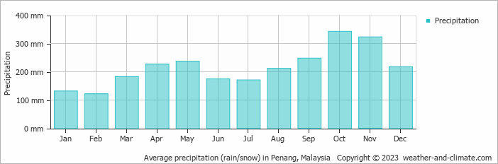
Location
Click on the blue arrow ![]() (top right) to see your current location on the map
(top right) to see your current location on the map
After reading quite a lot about The Hermitage (Bukit Arang Para – 999m with a prominence of around 297m), I was delighted that we finally visited this obscure peak in July. Very few groups hike here so there are no signs and some parts of the trail are completely overgrown with vegetation higher than the tallest of humans. Indeed, to call it a trail is wrong for much of the route we used. It was fascinating, exhausting and frustrating.
Finding a suitable guide for this peak is very difficult as almost nobody has been there in recent years. And those few who have been there know it is difficult terrain. There are a couple of possible access routes and we headed in from the north-east at Kuala Dal after leaving our cars at the main road junction and hopping on the guide’s 4WD (though a regular car can make it to the trailhead where there is very limited parking). There’s a recently closed illegal durian plantation on the left at the end of the cement road (99m). This sounds horrendous but just beyond this recently cleared land is a gorgeous wide flat rock platform which is actually the path of a river. It was easy to cross in July after a period of little rain at all, but in the rainy seasion this could be incredibly challenging if not impossible. In the rock, there are a couple of almost perfectly circular deep holes which are full to the brim of water even during the dry season. You definitely do not want to fall into one of those.
On the other side of the river is a forestry sign and this is the forest edge (124m). From here, assuming no groups have visited Arang Para recently, the going is tough and you will need to rely on the experience and instincts of your guide, plus GPS devices and so on. You may or may not pass a pig’s mud wallow as we did, or a large tree growing on top of a boulder. The terrain is steep, slippery and in places there is nothing to hold on to at all. In other places there are some objects to hold on to, but they are entirely covered with sharp spines. Gloves are a good idea for this one. We were lucky to encounter no leeches at all, which was only the case due to the prolongues period of dry weather. Normally this mountain is full of them.
Eventually you will reach what feels like a peak on a ridge (602m). There is a bit of breeze up here which is much appreciated. We dropped down a little before following along as close to the ridge as we could, following our guide with his machete. There was a bit of evidence of a logging track (824m) – less dense vegetation at one point higher up. We then reached a false peak (853m), dropped down a little to a col (824m) before ascending again. A cuboid-shaped stone (868m) we spotted is one of apparently several surrounding The Hermitage as marker stones to delineate the exact boundary of the old Arang Para hill station. So, beyond this stone, we were hiking on Herimtage territory.
Some of our group had turned around much lower down, after it became obvious that they would not manage this demanding hike in a single day and it could be dangerous trying to find the right way down in the dark. And those who had made it this far were all exhausted. The late start had not helped us either, due to delayes with the guide. Yet it seemed we were almost there and just had a short hike up to find what remained of The Hermitage.
I continued on ahead, energized with the thought that we were just metres away. On the left side, there was almost a view, with shorter vegetation suggesting that the area had been cleared a long time ago. But then we were faced with a wall of high ferns or bracken, taller than all of our group and incredibly dense. Out guide hacked through some of this and we tried to push through it. We were only 100 metres or so away, distance-wise from the Hermitage, yet covering just 10 metres was taking several minutes. It could be another 2 or 3 hours to make it through to the Hermitage, nevermind the second top 250-300m to the south where the collapsed beirut lies.
It became obvious that we were not going to manage to visit the southern top with the beirut, and we were already past our cut-off time. We should already be going down. But we allowed ourselves an extra few minutes to push through this horrible bracken for just a few more metres.
And it was a partial success. We found the stone walls which are the foundations of The Hermitage. Although a minor hill station, it would have been a surprisingly impressive building at the time, rather elaborate. The others sat down and had a snack and a drink. I continued searching for the water tank, parlour stove and empty wine bottles but found nothing. If we had started at daylight it would have been possible, but not with a 9am start. Disappointing but also great to see the foundations of this little-known colonial era relic. A shame we didn’t have more time to enjoy it at the top.
After a very short break we marched back down, getting slightly lost once or twice and having to consult the GPS. One of our group spotted a land turtle, a lovely thing to see and rather rare. We made it out just before dark, and met some friendly Orang Asli boys who were camping on the edge of the forest.
It took us 6 hours up and just over 3 hours back down. If you have the chance to visit this spot, do it, but make sure you start at first light or otherwise plan on camping up there for one night (no obvious water sources on this approach except at the trailhead).
Apparently Lady Weld’s bungalow was near Padang Rengas on the north side of the mountain, so the smaller secondary estate lower down called Cicely is probably on the northern slopes rather than the NE slopes that we hiked through. I wonder if there is any trace of Cicely these days. Perhaps very little.
After this excursion, I decided to visit the Pangkor Island area, but didn’t have sufficient time to visit the island itself after I lost a day due to car problems. There are a few worthwhile short hikes near Lumut and Pangkor, most notably Bukit Pangkor (350m and highest on the island) and two on the mainland… Bukit Engku Busu (331m) and Bukit 300 (approximately 325m with a prominence of 314m). After reading a view of Engku Busu that mentioned aggressive dogs at the Engku Busu trailhead I opted for Bukit 300, even though Engku Busu has a nice viewpoint on the trail.
Bukit 300 made a decent stroll and was well-marked from the car park at the west side at Teluk Batik. I met several other hikers there, including a guy who said Engku Busu was bad for mosquitoes. Well, at the top of Bukit 300, I encountered something at least as bad. A monkey was up there, but ran off as I approached. I then felt a strange tingling sensation on the back of my neck, like glitter laced with some kind of irritant, or a cloud of imperceptibly tiny biting insects. Was it sandflies? Was it the rengas leaf? Was it some kind of itchy caterpillar? Whatever it was, it was horribly itchy and painful for nearly a week and only subsided after I visited a pharmacy for some pills and cream.
Bukit 300 obviously used to be a popular spot to sit around at the top of, but now most of the wooden seats and little buildings are rotting and quite an eyesore. The summit sign is the same yelloe and red style as the summit sign on Gunung Korbu. I wonder if the two are linked. No beirut, unlike on Pangkor island apparently.
I was up and down in under 90 minutes. Perhaps I’ll do the other 2 next time.
I found a relevant quote in Ambrose B Rathborne’s “Camping and Tramping in Malaya”, first published in 1898, which is a pretty good read and available as a Stanfords Travel Classic. On p130 (my edition) he writes ‘Gunong Bubu…a landmark for many miles around, and on its slopes various experiments were being carried out in the cultivation of different products suitable to the soil and climate.’ This may well refer to Arang Para.
Another place of significant interest in this area is Beruas, down at the southern end of the range. There is a gunung there – Gunung Sunting Buloh – which is only around 400m high but has a beirut on top and can be hiked in 3 hours or so according to Cik Fizi. Even more interestingly, the Beruas area is thought by many to have been the site of Gangga Negara – a “lost, semi-legendary Hindu kingdom mentioned in the Malay Annals” that existed perhaps up until around a thousand years ago. Beruas Museum has a collection of artefacts found locally. Definitely worth a look if in the area….
Just about managed a hike to the top of Gunung Bubu as a weekend trip! Most people would regard the itinerary as extremely rushed, but the choice for me is either stay in Jakarta or give it a try!
Arrived in Penang late on Friday night, took a taxi to Butterworth (RM125 – bloody expensive, especially considering in the opposite direction it is just RM68!) It took around 40 minutes. Stayed in the closest hotel to the train station (KTM station) and got an early train down to Kuala Kangsar on the Saturday morning.
Met my guide at the station and set off for Ulu Kenas. This would be the first hiking trip up Gunung Bubu for several months, with it being closed for the rainy season until the end of January. About another 17 or so hikers came along for this.
The admin needs taking care of at this trailhead, with a security post and an information counter. Most folk book online these days using the forestry department booking site, then take a print out of the confirmation on the day of the hike.
Saw some lovely hornbills pretty close up just an hour or so into the hike. As is usually the case with larger groups, people find their own pace and you end up in smaller groups before too long. This didn’t happen before we made the mistake of following the fishing path to the river, instead of taking a right (un-marked). No surprise really, given no groups had been up here for a while. We managed to cut up to the mountain path just 5 minutes or so higher up to the right and were fine from that point on, aside from a few logs and branches that needed cutting after 3 months or so of few or no hikers over the rainy season.
We were up at Camp Ulu Gading in around 4 hours and thirty minutes total, but with a lots of breaks on top of that so not until about 3:30pm. Getting up to the summit and back down in time for my train back up to Butterworth the following afternoon meant that we would have to do the summit on the same day rather than risk it on the next morning. So the four of us ahead of the rest of the pack set off and were up in another 2 and a half hours. Some very steep sections. Some nice views from the last water point, but misty at the summit.
We came back down in the dark, something I would not recommend unless you cannot avoid it. One of our group dropped his walkie-talkie in the undergrowth, and it took a good 15 minutes to find it again!
Three of us dashed back down from camp the next morning, making great time. We were down at the carpark by just after 11am. A few leeches came off the outside of my leech socks, and quickly moved off to look for new victims! None managed to get inside the socks, but several got me on the back just above the beltline, and one got me on the neck the previous evening!
Back in Jakarta, unpacking later the same night, no less than 5 leeches has made it through immigration with me, on an international Air Asia flight, and were soon trying to explore my apartment! Amazing how well they can hide!
The additional two peaks sound very interesting – perhaps the Padang Rengas trail is more interesting because of this, but just a shame it requires more time! Also… the Hermitage. I will have to explore that sometime, perhaps along with Gn Peninjau, the highest of the Meru range between Kangsar and Ipoh.
Many thanks to Cik Fizi and friends for a great weekend.