Author name: Dan

Buku Sibela

BUKU SIBELA

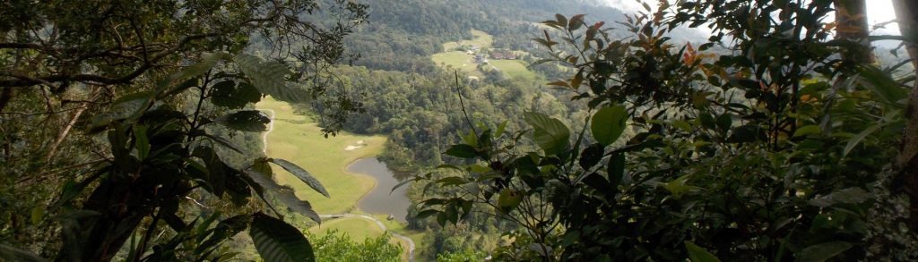
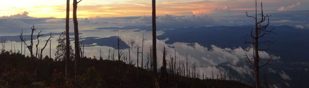
Buku Sibela is the highest point of the island of Bacan and lies within Gunung Sibela Nature Reserve. It is also the highest peak in North Maluku province. Until quite recently, very few hikers had heard of it, but it is slowly growing in popularity and the superb views from the summit ridge make it well worth the effort getting to.

Buku Sibela Read More »

Gunung Sinsing

Facts Photos Bagging It! Gunung Sinsing is part of the large Trusmadi range and lies around 8 kilometres north-east of the slightly higher parent peak Trusmadi. Depending on how you classify mountains as being separate from one another, Sinsing is the third-highest peak in Sabah and Borneo and indeed Malaysia as a whole. The trailhead

Gunung Sinsing Read More »

Gunung Penrissen

PENRISSEN

Mount Penrissen is on the Indonesia-Malaysia border (West Kalimantan and Sarawak) and is the highest peak of a large mountainous area south and south-west of Kuching. It is most commonly accessed via the Borneo Highlands Resort and golf course on the Malaysian side. As the hike takes around 6 hours to complete, it makes a great day out from Kuching (2 hours away by car) and there are some excellent views down into Indonesia.

Gunung Penrissen Read More »

Paungchon Taung

Facts Elevation: 1,159 m (3,802 ft) Prominence: 1,110 m Ribu category:  Kurang Tinggi Region:  Southern Myanmar Coordinates: 14.3942, 98.0358 Rating: World Ribus ID: 68648 Bagging It! Unknown at present. Practicalities Getting there: Unknown at present. Permits: Unknown at present. Water sources: Unknown at present. Local Average Monthly Rainfall (in Yangon) Location Click on the blue arrow (top

Paungchon Taung Read More »

Huingye Taung

Facts Elevation: 1,400 m (4,593 ft) Prominence: 1,055 m Ribu category:  Kurang Tinggi Region:  Southern Myanmar Coordinates: 14.4183, 98.2400 Rating: World Ribus ID: 68687 Bagging It! Unknown at present. Practicalities Getting there: Unknown at present. Permits: Unknown at present. Water sources: Unknown at present. Local Average Monthly Rainfall (in Yangon) Location Click on the blue arrow (top

Huingye Taung Read More »

Nwalabo Taung

Facts Elevation: 1,564 m (5,131 ft) Prominence: 1,186 m Ribu category:  Kurang Tinggi Region:  Southern Myanmar Coordinates: 13.9325, 98.4792 Rating: World Ribus ID: 68618 Bagging It! Unknown at present. Practicalities Getting there: Unknown at present. Permits: Unknown at present. Water sources: Unknown at present. Local Average Monthly Rainfall (in Yangon) Location Click on the blue arrow (top

Nwalabo Taung Read More »

Mulayit Taung

Facts Elevation: 2,030 m (6,660 ft) Prominence: 1,479 m Ribu category:  Tinggi Sedang Region:  Southern Myanmar Coordinates: 16.1833, 98.5275 Rating: World Ribus ID: 68543 Bagging It! A well-established destination for locals, there’s a white pagoda at the top with steps all the way up. Superb views. Near the summit is the Mulyait Monastery. A popular place for

Mulayit Taung Read More »

Myinmoletkat Taung

Facts Elevation: 2,072 m (6,798 ft) Prominence: 1,856 m Ribu category:  Tinggi Sedang Region:  Southern Myanmar Coordinates: 13.4667, 98.8050 Rating: World Ribus ID: 68511 Bagging It! Unknown at present. Practicalities Getting there: Unknown at present. Permits: Unknown at present. Water sources: Unknown at present. Local Average Monthly Rainfall (in Yangon) Location Click on the blue arrow (top

Myinmoletkat Taung Read More »

Mela Taung

Facts Elevation: 2,080 m (6,824 ft) Prominence: 1,708 m Ribu category:  Tinggi Sedang Region:  Southern Myanmar Coordinates: 17.2024, 98.0796 Rating: Other names: မယ်လတောင်  World Ribus ID: 68520 Bagging It! Unknown at present. Practicalities Getting there: Unknown at present. Permits: Unknown at present. Water sources: Unknown at present. Local Average Monthly Rainfall (in Yangon) Location Click on the

Mela Taung Read More »

Lunghpawng Ku

Facts Elevation: 1,750 m (5,741 ft) Prominence: 989 m Peak category:  Spesial Region:  Western Myanmar Coordinates: 26.6883, 96.0800 Rating: Bagging It! Unknown at present. Practicalities Getting there: Unknown at present. Permits: Unknown at present. Water sources: Unknown at present. Local Average Monthly Rainfall (in Mandalay) Location Click on the blue arrow (top right) to see your current

Lunghpawng Ku Read More »

Scroll to Top