
Facts
- Elevation: 1,610 m (5,282 ft)
- Prominence: 1,602 m
- Ribu category:
 Kurang Tinggi
 - Province:
 Jawa Tengah (Central Java)
 - Coordinates: -6.6162, 110.8903
- Rating:

 (10 votes) Add your rating
 Loading...
 - World Ribus ID: 69070
Photos


Bagging It!
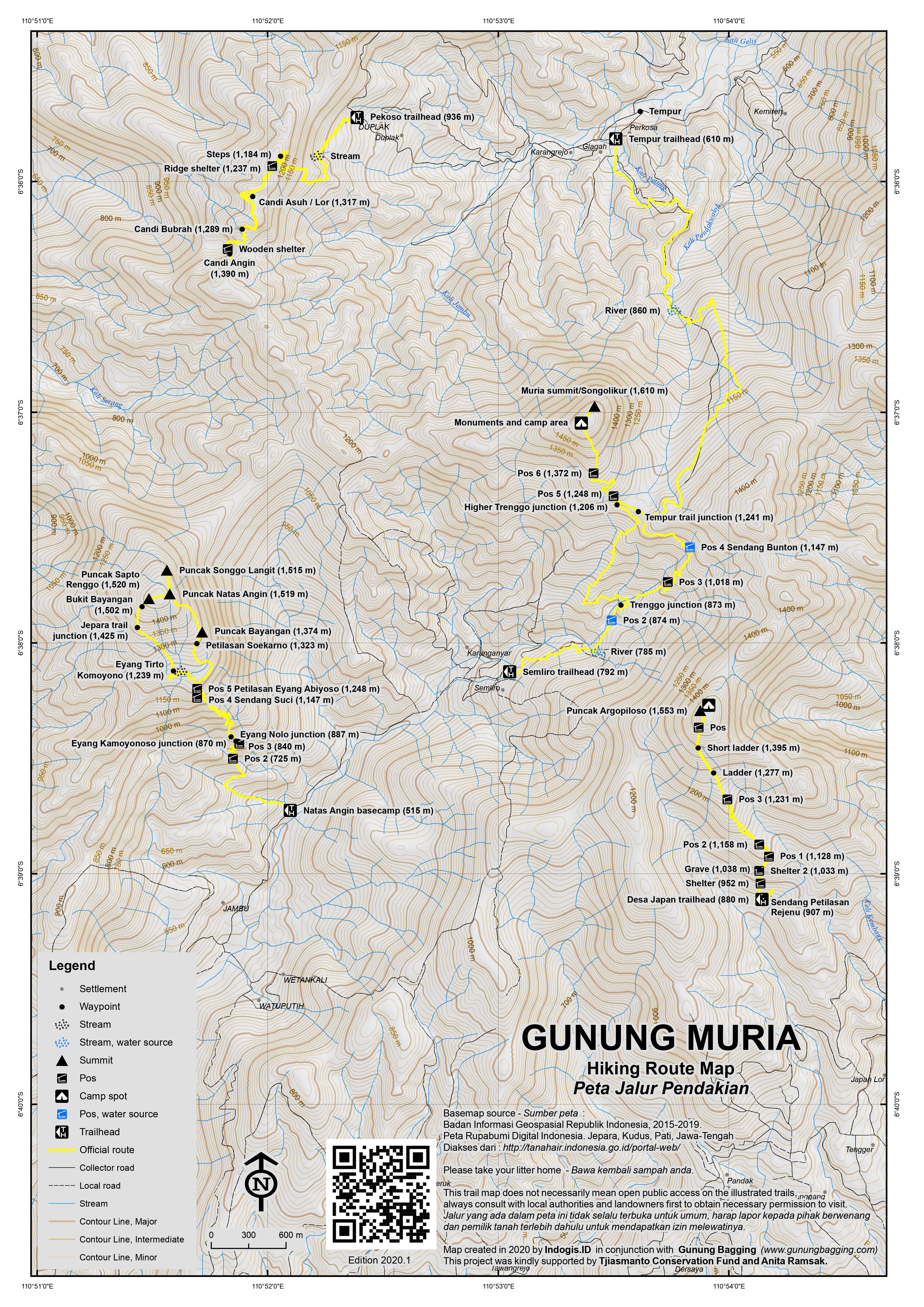
Gunung Muria is a dormant volcano – apparently having last erupted just over 2000 years ago – which dominates the Muria peninsula on the north coast of Java, east of the city of Semarang. The Muria mountain is actually a range of different peaks, of which Songolikur is the highest. It is a very popular hike with local students at weekends, but considering the spectacular views of the Central Java mountains and northern coastline from the summit, and the shortness of the hike itself, relatively few hikers come from afar specifically in order to climb it.
It can be climbed from the south at Semliro, Rahtawu (30km north of Kudus) or from the Jepara side via Tempur which is to the north of the summit, but the former is by far the most common route used to reach the highest peak. There are other trails up nearby peaks too.
The whole area north of Kudus (meaning ‘holy’) is a place of pilgrimage as this region was very important during the beginnings of Islam in Java. There are many grave sites on the slopes of the mountain, most notably near Colo village, at the foot of the Argopiloso peak. Many visitors come to the tomb of Sunan Muria, an early Islamic preacher in Java. Indeed, the mountain is dotted with cairns, prayer huts, small Hindu statues and warungs. The highest peak is often referred to as Peak 29, but there are different stories relating to why this is so and nobody seems to have the definitive answer. There are many minor peaks in the mountain range so it could well be that Songolikur is the highest of 29 peaks in the Muria range. However, some people suggest it may have a more ancient, mythical meaning related to Wayang Kulit. Be sure to ask locals for their explanation.
The starting point for the hike to the the true summit of the Muria range (Songolikur peak) is just beyond the village of Rahtawu and it takes a leisurely 3 hours to reach the summit. To get to Rahtawu it is best to take an ojek (motorcycle taxi) from the nearby town of Kudus, although angkots operate during the daytime. The journey is delightful – slowly rising into the hills by the side of the river valley – and at weekends it is a favourite spot of young couples eager to escape the watchful eyes of their parents! Beyond the main village of Rahtawu, the road continues to snake upwards into the mountain range and into Semliro hamlet (792m). Take a left over a tiny white bridge to where the trail begins. The starting point is a trail beyond the cluster of houses and the owner of the house on the left will happily let you store your motorbike inside while you climb. In 2020 there is also sufficient parking space for a small number of cars.
The trailhead is at an elevation of 792m so it’s only another 800 metres or so of ascent to the very top. The first section of the trail is along fairly flat and well-defined farming tracks which follow the river into the mountain range and cross several streams including at 782m and Pos 2 (874m).
Shortly after Pos 2, the trail divides and either one will lead you to the summit. Straight on leads up a steeper but less popular route known as Jalur Trenggo / Trengggu and meets the main trail just before Pos 5.
Right leads up via Pos 3 (1,018m – also known as Pos Zigzag) which is a wooden building at a sharp corner in the trail. Views south are already very impressive indeed and the imposing rockface of the Abiyoso peak of the Muria range on your left is pretty spectacular. Soon afterwards, you reach Pos 4 Sendang Bunton (1,147m) – a camping barn and a warung with freshly made gorengan (fried snacks), noodles and coffee/tea. It would appear to be open 24 hours a day for local student hikers and farmers.
Beyond Pos Bunton there is a small signposted junction (1,241m). The right turn goes over the hillside and drops down to the village of Tempur (610m trailhead) beyond the peak of Muria itself. Do not take this turn unless you are descending and doing a traverse of the range, just keep on heading straight along the more obvious path to the Songolikur peak itself.
Shortly after the Tempur junction is another junction (1,206m) where the Trenggo/Trenggu trail meets up with the main trail. Soon after that is Pos 5 (1,248m). Another hut comes into view near Pos 6 (1,372m) and is actually the first of many empty huts that look as though they are sometimes used to sell hikers snacks and drinks. There are some vegetable plots here and it feels very much like somebody’s well-kept garden. There are also one or two tiny shelters with what appear to be gravestones inside them.
After the collection of huts, the trail starts to rise steeply up the side of Muria’s highest peak itself. From here you should be able to see Merbabu, Merapi and Lawu in the distance. There are two tiny prayer huts (1,426m and 1,554m) on the steep side of the Songolikur peak. As you finally reach the top of the mountain range, you are confronted with two red welcome posts and an Indonesia flag. There are all manner of buildings up here – another tiny shop/warung (run by the elderly Pak Sijan, once again seemingly 24 hours a day!), a telecommunications mast of some sort, camping barns and a walled enclosure with several Hindu statues inside. If you have a look at your GPS, you should see a reading of approximately 1,600m – 10 metres below the highest point of the range (as according to the Bakosurtanal map).
Indeed, the true summit itself is a further five minutes’ walk along a short vegetated ridge which is crowned with a cement pillar halfway along it. The highest point, which is slightly further north, is a collection of boulders and a small Hindu shrine. The location offers great views over the coastline of the Muria peninsula and eastwards along the north coast of Java. The view also now encompasses the twin giants of Sindoro and Sumbing to the southwest. Muria may not be one of the highest peaks in Java, but in good weather it is definitely one of the finest viewpoints. Watupayon is the triangular peak east of Songolikur where the sun rises.
There are places to camp on the summit ridge – and indeed you can stay at Pos Bunton if you wish – but considering the short length of the hike, it can easily be enjoyed without the need for camping equipment. It is best to reach the summit in time for dawn to enjoy the sunrise.
After you have leisurely returned the same way, there are several other natural attractions in the area such as several minor waterfalls right next to the road which leads back into Kudus.
Other peaks in the Muria range:
Puncak Argopiloso (1,553m)
Lying further south-east of Songolikur, in the direction of Gunung Lawu when viewed from Muria true summit. Puncak Argopiloso can be climbed from the warungs near Sendang Petilasan Rejenu above Desa Japan, Colo (880m trailhead). It only requires 2 hours up and 90 minutes back down.
The trail leads via the holy well (Sendang Petilasan Rejenu), Shelter 1 (952m) which houses a grave, Shelter 2 (1,033m) which is near a grave with a wooden barrier, Pos 1 (1,128m) which is next to an ancient wall or remains of a stone structure known as Petilasan Syekh Subakir, Pos 2 (1,158m) and Pos 3 (1,231m). After Pos 3 are two short ladders over particularly steep sections of trail, after which the forest recedes and the panoramic views can be enjoed in clear weather.
The summit has enough space for 3 or 4 tents and the views are superb in good weather.
Natas Angin / Abiyoso (1,520m)
Natas Angin is a very impressive peak further southwest that is often climbed from Rahtawu near Kali Banteng waterfall further towards Kudus on the west side of the road up into the Muria mountain range. This is the second most famous trail and mountain peak in the Muria range, lying just 3 or 4 kilometres south-west of Songolikur. It requires just over 2 hours to the top and just under 2 hours to descend. Water is available at Pos 2 and 4 and the warungs when open.
The trailhead and parking spot is on the main road at 515m and the trail leads via Pos 2 (725m) where there is a shelter and a stream, Eyang Kamoyonoso junction (870m), Eyang Nolo junction (887m), Pos 3 (840m) which sometimes has a warung, and Pos 4 Sendang Suci (1,147m) which has a pool of holy water.
The next major place on the trail is Pos 5 Petilasan Eyang Abiyoso (1,248m) which is a hamlet consisting of at least 2 warungs selling drinks and snacks plus countless prayer buildings and ancient religious sites. The warungs are usually open over weekends and on public holidays when plenty of pilgrims or hikers are expected. There is also lots of space to camp here although the view is more limited than higher up the trail.
From here, there are two routes to the top – Jalur Bebek and Jalur Naga. Jalur Bebek is slightly longer and leads via pleasant forest and past some fascinating ancient sites of unknown antiquity. Jalur Naga is direct and leads along the ridge of the mountain with a considerable drop on the right side. Most hikers use Jalur Naga, but we recommend trying Jalur Bebek on the descent.
Assuming you choose Jalur Naga, the next major landmark is Petilasan Soekarno (1,323m) which is named after Indonesia’s first president who apparently prayed here at some point. Beyond that is Puncak Bayangan (1,374m) which has brilliant views to Songolikur and Argowiloso. From here onwards the trail is open with great views in all directions. Take care as the ridge is narrow and a little exposed in places.
There are actually three separate peaks at the top. Puncak Songgo Langit (1,515 m), Puncak Sapto Renggo (1,520 m – also known as Puncak Tugu) and the main Puncak Natas Angin peak (1,519 m). The latter is reached first and is the main destination for hikers who take their photos next to the wooden summit sign. There is enough space for 2 or 3 tents.
Songgo Langit can be see a little way to the north. It takes less than ten minutes to hike via the narow and steep ridge. There is a shelter on Puncak Songgo Langit and good views further north to more distant peaks such as Puncak Candi Angin.
To reach the true summit which is Sapto Renggo – or Puncak Tugu because of the cement triangulation pillar on top – you need to retrace your steps to Puncak Natas Angin and then head along the ridge to the west for just 3 minutes or so. Sapto Renggo has good views in the Jepara direction is just about the highest peak of the three Natas Angin tops, being just a metre or so higher than the Natas Angin sign peak. There is enough space for 1 or 2 small tents here.
Instead of descending via the Naga trail again, you can return to Pos 5 via the less-popular but very atmospheric Bebek trail (‘jalur bebek’) which leads down from Sapto Renggo to Bukit Bayangan (1,502m), the trail junction with a route leading up from the Jepara side (1,425m), Eyang Tirto Komoyono (1,239m), a dry stream (1,203m) before meeting the main ‘Naga’ trail at Eyang Sekembaran (1,251 m) on the edge of the Abiyoso complex.
Puncak Candi Angin (1,429m)
Candi Angin is a ridge of peaks with ancient Hindu temples, the most famous and impressive of which gives its name to the ridge. It can be hiked from the village of Pekoso (936m) above Tempur. Given the high starting point, the the main temple of Candi Angin can be reached in about 1 and a half hours. The trail zigzags up through coffee plantation before passing some kind of small electricity substation and then cement steps (1,184m).
Soon afterwards the ridge is reached. There is a shelter on the right (1,237m) but you need to follow the top of the ridge to the left to reach the temples. At 1,275m is an unmarked junction, with a left turn leading up to a minor peak with the remains of a temple known as Candi Asuh or Candi Lor (1,317m). As it is only 3 minutes from the main trail, this minor summit is well worth a visit.
Continuing along the main trail, the next landmark is Candi Bubrah (1,289m) which means ‘dismissed temple’ and is rather impressive. And finally, a little further on is Candi Angin itself – ‘the temple of the wind’ – (1,390m). There are a couple of signs, a shelter with two floors, and several places to make offerings.
The highest peak here is actually a bit further beyond the temple and called Gunung Candiangin Kidul (1,429m) on the Bakosurtanal map. However, if you wish to visit this, please do not walk through the remains of Candi Angin but find a way round that does not disturb this monument.
It takes just ovver one hour to return to the trailhead.
Bagging information by Daniel Quinn (updated February 2021)
Further peaks in the region:
Gunung Genuk (670m)
Several kilometres to the north of Gunung Muria is the northernmost mountain in Java. At just 670m it is really just a hill but it has considerable historical significance to those interested in the history of mapping in Indonesia.
It was here in the 1870s where the very first trig point (topographic surveying pillar often found on hill summits) was established. This became the first non-zero reading (presumably they had a zero from sea level from somewhere near the Portuguese Fort a few kilometres away) and the basis from which all other elevations on Java and nearby islands were derived.
In December 2018, the remnants of the pillar are still easily found on this rarely-hiked hill-top, along with a couple of other construction remains which may be from a later date.
The village of Guwo is the starting point for the short one-hour hike to the top. Dusun Guwo is nestled in the Genuk hills at an elevation of around 400m and there is a reasonable road all the way there. Allow around 90 minutes from Jepara and expect to have to ask locals for directions!
From Guwo you will see a telecommunications tower on the southern top of Genuk (roughly 500m elevation) but the true summit is further north. You will probably need to take a local villager as a guide or else ask for directions. There is a well-used muddy, slippery plantation path leading to well over 500m but soon you enter dense vegetation and if nobody has hiked here in recent months then it will be slow going indeed.
On the higher slopes, be very careful on what is unstable and occasionally very steep ground with little to hold onto should you fall. Eventually you will reach an area with large rocks just before the summit and then will find yourself on the small summit with a pleasant panorama of Gunung Muria to the south, the 806m-high Gunung Celering / Gunung Argo Puro Lasem to the south-east, and the Portuguese Fort (‘benteng portugis’) and little Pulau Mandalika to the north.
On the ground around you are the remains (both from the 1870s and some probably more modern) of simple constructions that were the basis for the entire Java triangulation system.
After brushing yourself clean of the many tiny ants on this hill, and admiring the pleasant view, you can be back down in Dusun Guwo in 40 minutes or so.
Bukit Gajah (506m), Karimunjawa Islands
Out in the Java sea to the north-west of Jepara is an increasingly popular mini-archipelago called Kepulauan Karimunjawa. The only significant hill is known as Bukit Gajah (‘elephant hill’) but there are currently no reports of anyone having recently hiked to the top. A video on Youtube shows a local group hiking halfway up after getting permission from the forestry department in the main town. As of October 2018 there are daily Wings Air flights from Semarang (just 25 minutes) so it is quite possible that Bukit Gajah will become better-known soon. The usually-accurate Bakosurtanal maps suggest the highest peak is 664 metres, about 700 metres east of Gunung Nyamplungan (566m) but both of these heights seem overly-high when compared to other sources.
Gunung Argopuro Lasem (806m)
About 70 kilometres to the east of Gunung Muria, also overlooking the northern coastline of Java, is Gunung Argopuro Lasem. Not to be confused with the giant Argopuro in East Java that requires 3 days to traverse, this mountain near Rembang is listed as 803m high on the Bakosurtanal map but 806m in many other sources. It seems to be called Gunung Lasem locally, with a summit peak known as Argopuro (or Argo Puro).
It can be climbed from several directions, but by far the most popular is from the south at the friendly village of Ngroto (315m), which is around 25 minutes by motorbike or car from Lasem and accessed via Pancur. It takes most hikers less than 2 hours to reach the summit and the trail passes Pos 1 and Pos 2 but these do not have signs at the time of writing (2019).
Despite the lack of signs, the trail is pretty obvious and if you head up and stick to the main trails you should be fine without a guide (but best don’t hike alone). At 630m you will find yourself on a pleasant narrow ridge with views down to both sides. You should have reached this point in about one hour from Ngroto. The trail then skirts round the highest part of the hillside before reaching a junction (740m) next to a boundary pillar of some sort.
The trail down to the right was closed off with branches in 2019, and it is unclear where this starts from, and the way to the summit is a sharp left. Just beyond this junction are old foundations of a small building (750m) presumably from Dutch times. If anyone knows what was up here then please leave a comment below. It is very pleasant hiking from here, with a couple of decent, flat camp spots (785m) and then the airy summit ridge itself.
In clear conditions the summit offers views south to Gunung Lawu, west to Gunung Muria, and north to the Java Sea. There are actually two minor summits, with the pillar and flagpole between them. It is quite likely that the 803m figure on the Bakosurtanal map refers to the height at the pillar, as both tops, east and west appear to be 2 or 3 metres higher than the pillar and therefore may account for the 806m figure given elsewhere. Be careful between the pillar and the west top as there is a sheer drop next to a rock.
From the western top you can look down to the town of Lasem and beyond along the north coast to the Muria peninsula. From the eastern top you can observe Java’s northern coastline east of the range. You can be back down in Desa Ngroto in about 90 minutes.
Other trails include from the villages of Gowak and Kajar which are to the west of the mountain, only 15 minutes by car or motorbike from the town of Lasem but unless a group has used them prior to your own visit both of these trails are likely to be overgrown and therefore more time-consuming. There is an ancient, small Hindu shrine in Gowak called Candi Malad. This apparently dates back to approximately 1351.
The traditional Chinese heritage buildings (‘Tiongkok Kecil’) and unique batik shops in Lasem are very much worth a visit for a few hours when you are in the area. You will probably be surprised that you hadn’t heard of this unique place before.
Trail Map
For a high quality PDF version of this and other trail maps, please download from our Trail Maps page.
Practicalities
- Getting there: For domestic flights from or to Central Java, such as the airports in Semarang, Solo (Surakarta) and Yogyakarta/Jogjakarta we recommend Baolau. There are plenty of buses to Kudus from Semarang. From Kudus, take an ojek or angkot towards the Muria mountain range and Rahtawu village (30km). The starting point at Desa Tempur is difficult to reach, lying nearly 2 hours away from Jepara.
- Guides and GPS Tracks: Want a PDF version for your phone? Looking for a guide? Need GPS tracks and waypoints? Gunung Muria information pack can be downloaded here.
- Trip planning assistance: Would you like Gunung Bagging to personally help you in arranging your whole trip? Please contact us here.
- Permits: None required but take a photocopy of your passport photo page just incase.
- Water sources: Finding water on the usual hike from Rahtawu (south of the peak) is never a problem. There are many streams and even tiny village shops selling water on the trail itself.
- Accommodation: Try the Booking.com map above or use this link to search for suitable hotels, homestays, resorts and apartments for your trip.
- We recommend Safety Wing as travel insurance for overseas travellers and tourists hiking up to elevations not exceeding 4500 metres.
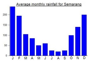
Local Average Monthly Rainfall (mm):
Location
Click on the blue arrow ![]() (top right) to see your current location on the map
(top right) to see your current location on the map
Origins and Meaning
(probably) High and Noble Mountain. Probably muria (pronounced /MOOR.yo/ in Javanese) is a variant of the Javanese word mulya (pronounced /MOOL.yo/) meaning (among other things) “high, noble”. Note that in the evolution of Indonesian languages /l/ often morphs into /r/ and vice-versa because the points of articulation of /l/ and /r/ are almost the same inside the mouth. Thus we have (for example) the title of the ancient spirit deity of the southern ocean Nyai Roro Kidul, who is also often Nyai Loro Kidul. (George Quinn, 2011)
A note on Gunung Genuk. From photos on Google Maps it appears that a new pillar has been constructed recently (perhaps 2021) to commemorate the spot being the first trig point in all of Indonesia. It also appears that the area has become protected forest under the name Gunung Celering, which based on the Periplus map I had always understood to be the alternate name for Argopuro Lasem many km to the east. But perhaps not. Anyway, nice to see Gn Genuk being commemorated for its historical importance.
Rather like Anjasmoro, the Muria mountain range is one with numerous peaks, meaning you need several trips to understand it as a whole. I still had Argopiloso and Candi Angin on the list to do, and despite awful weather it was a great day out. Yes, I did them both in the same day which was extreme, because despite them only being 5km or so apart on the map, the access points are about 2 and a half hours from each other by road!
We stayed in Kudus, which like many places near the north coast of Java has suffered from bad flooding the last few days. Up to Colo itself is easy enough by road but to get the the Argopiloso trailhead you definitely need a bike rather than a car as the road is very narrow.
It took us 2 hours to the top, but there was no sunrise, or rather the sunrise was not visible to us. The trail is wilder than the ones up Songolikur and Natas Angin, with a lot of slippery tree roots. We were back down in 1.5 hrs.
The starting point for Candi Angin is Tempur, and whilst a traverse of Songolikur is possible down to Tempur, a crossing via Agopiloso is rarely done so it would be far more time consuming to attempt than just driving round to the north. We drove round via the eastern side (Pati) but the western side (Jepara) would take a very similar amount of time.
Tempur is a fantastic, scenic village, with a beautiful river and rice terraces beneath the steep cliffs of the northern peaks of the Muria range. Good coffee in this area too, available from the side of the road. The fact this spot takes a lot of time to get to is perhaps why it is still rather unspoilt. It feels rather unlike Java, more like a remote part of Sulawesi.
The last time my guide went up Candi Angin, it took him several days to explore the summit ridge and numerous peaks, but he ascended from the western side (Jepara). Candi Angin is now moderately well known, and the trail is very easy indeed, with cement for much of the way that looks slippery but is actually not slippery at all. It took us just 1.5 hours to the main Candi Angin temple itself and just over 1 hour back down to the village.
Candi Angin is in my view one of the special spots in Java. We didn’t get good luck with the weather, so no views, but it was still a fantastic trek to a place that obviously had huge significance in previous centuries.
Had planned a quick weekend trip to Argopiloso/wiloso and Puncak Candi Angin temples, but as has been the theme of the year this had to be cancelled.
There has been an awful lot of ineptitude in 2020, and perhaps the worst in this part of the world was when it was suddenly announced on 15th December that normal rapid tests would no longer be acceptable for travel between provinces, whether by train, bus, plane or whatever else. This would start on Dec 18th – so just 3 days’ notice. And for flights into Bali you would need the expensive PCR test.
So, first came the tens of thousands of cancellations of holidays booked in Bali by those not willing to fork out an extra however many million rupiah to pay for a family to get swabbed. I feel very sorry for hotel owners, guides, and even airlines who perhaps saw this holiday period as a tiny chink of light in an otherwise dark universe.
I phoned Kereta Api several times and at first they weren’t sure as apparently they had received no official say on new policies. As predicted, hundreds of customers were contacting them on social media asking what was going on and whether all passengers would need antigen swabs (more expensive at around Rp400,000) per person.
The communication between government departments seems to have been utterly woeful. Someone announces a new policy to the media before meeting with relevant bodies to, you know, actually make a plan! I wouldn’t have minded too much if the info had been clear and decided on, say two weeks in advance. But three days is not sufficient, especially bearing in mind the greater difficulties in getting an antigen test in many areas and not being left enough time to cancel and get some kind of refund.
Even worse, all this talk of h-2 or h-3 that Indonesia uses, just complicates matters and is almost entirely meaningless. The rules state you must get your test no later than h-2 or h-3 where h is the day of departure, but that the result is valid for 14 days. How the hell does that work then? If your result is valid for 14 days then it doesn’t matter whether you travel on day 1 or day 14, only that you cannot use it on day 15 and that you may need to wait a while depending on your clinic to actually receive the results. Most take the test and fly the same day. But, yes, h-2 but with a validity of 14 days…. the mind boggles, and I heard of some cases in which folk paid for a second test to be within 2 days of their flight date, despite the results being valid for 14 days. That’s because it sounds like maybe the test result is actually only valid for 2 or 3 days when they use h-2 and h-3 type terms. Good god! Zero logic.
Well, right up until now, 18th Dec, we have regional authorities saying the new rapid antigen rules that were rushed out with no proper warning are valid and in provinces such as Jawa Tengah they will be checking cars and buses at toll exits and passengers at train stations and airports. There are some official images on Instagram about it. All must have a rapid antigen swab test or will be forced to take one. But at the same time, KAI are still following old guidelines, accepting normal rapid tests, as they haven’t received proper info on new regulations. A total headache. Not to mention that the new tests cost more than most train tickets! So, it ends up being a case of do you trust authority A or B more, how do you know it won’t get changed yet again with almost no prior warning, and how much hassle can you tolerate for what should be a simple journey to Semarang?
Anyway, I left it as late as I could and then cancelled just over 3 hours prior to my planned train departure time. I will only get 75% of the ticket money back, as if i wanted 100% I would need to go to a station which would obviously cost more money than the 25%. I was too late to get a refund on my hotel in Semarang. Luckily my guide/contact for Muria didn’t mind when I said best delay until next year, as he had seen the news too.
So, in short more money down the drain due to a woefully inadequate lack of communication and professionalism. I got a normal rapid test last week, but haven’t actually been able to use it for anything. What a joke!
Next plan is Sulawesi for which we will have to get the antigen swab tests. Just hope the authorities don’t change the rules yet again once we get it. A crap end to a crap year in which most of us have seen very little pleasure at all and just increasingly inept behaviour by those in charge of ordering us around, hemming us in, forcing us to go this way or that way, in increasing violation of basic human rights and freedoms. And if being vaccinated does not necessarily mean we cannot contract it or pass it on to others, then what is the end to this godawful mess?
This is a mountain that is close to my heart and has been since I first climbed it about ten years ago. A couple of friends wanted to bag the Ribu (Songolikur) so I thought I’d go and do Natas Angin at the same time (the other interesting peak is Argowiloso but currently still closed).
We drove from Jakarta and got there faster that you would do by train and Grab. About 6 hours total to Kudus where we got a few hours’ sleep. The toll road itself however is not that cheap, costing around 350,000 each way, so unless you have a couple of friends it makes sense to get the train instead.
Two chaps from the Natas Angin trailhead came up with me, both fast and knowledgeable. Being a Monday morning there were only a handful of other hikers, making for a pleasant experience. After a cup of tea at the Abiyoso warungs, we were on Puncak Bayangan just as the sky began to lighten. It was little hazy, so no views of Sindoro, Sumbing etc, but the views to the many other peaks in the Muria range were great.
The trail used to lead directly up to the first peak (the Natas Angin sign peak) but it was recently altered, turned into a little zigzag to make a bit easier and less dangerous near the very top. We wandered over to the Tugu peak which is about 1 metre higher according to my GPS which agreed with the 1520m figure given on the Bakosurtanal map. And then after coming back to the Natas Angin sign viewpoint peak we walked along the narrow ridge northwards to Songgo Langit, the third-highest, just 5 metres or so lower at 1515m but clearly less popular and with less space for camping. I’d definitely recommend heading out to this peak – despite looking quite distant and beyond a steep drop, it takes less than 10 minutes to reach and the trek is exposed (take care!) and great for photos.
We came back down via Jalur Bebek and whilst the views are not as panoramic, the ancient sites are well worth a look. Many of the signs are rotting and difficult to read now. It’s a fascinating range – I could well imagine a great book being written about the mountain, the ancient sites, and the people who live on its slopes and sell snacks in its warungs! Gunung Candi Angin further north is lower but it too has some interesting ancient sites. Perhaps next time… along with Argowiloso….
After stopping in a truly unique service station housed inside an old sugar factory building near the toll somewhere near Brebes (Rest Area M260) were we back in Jakarta just after dark.
When I first studied a map of Java (the Periplus one back in 2008 which remains pretty much the same today) I remember looking at both Gunung Muria on its own peninsula east of Semarang and a smaller peak, on a promontory further east beyond Rembang that was (and still is) labelled Celering (806m). Well, this is actually Gunung Lasem, or Gunung Argopuro Lasem, and like most of the places in this part of Java, the borders of Central and East, it is well worth exploring (but it took me a decade to get around to it).
I’d been to this area before, visiting the Toer house in Blora, Kartini’s grave, teak woodland near Cepu and the magnificant and bizarre Bledug Kuwu. Gunung Lasem is quite a distance from the main trainline running between Semarang and Surabaya and is probably best approached from Semarang (bus to Rembang). However, I don’t like buses and thought getting off at Bojonegoro train station and then back on at Cepu the following day would give me an excuse to see a bit of the land.
Bojonegoro at 4am didn’t seem like such a great idea when I arrived, but finally got a Grabcar to take me up towards Lasem. As it was too early to check in to my accommodation, I had a wander along the beach at Pantai Caruban, a pleasant beach which would be even more pleasant if there a bit less plastic floating around.
The gunung itself is a few km to the east of town, clearly visible from the road out the beach. I then got a Grab bike to Gowak to see the ancient Hindu Candi, which was very well looked after but rather small. Worth the short trip from Lasem though. And then back in Lasem I was surprised to see all the old buildings (200 years old at a rough guess) – despite being a unique spot in the history of Chinese Indonesians I had never known of the place, nor that if you walk one minute off the main road you are in a delightful warren of old, crumbling traditional Chinese buildings many of which are restaurants, basic hotels and batik shops. I stayed at Tiongkok Heritage (the only place on Traveloka at the time) and what a great place. Very friendly staff who gave me a drink of Kawista syrup. This tasted delicious but I bought some and took it home and it was not at all the same – maybe I didn’t shake the bottle enough or perhaps used too much of the syrup mixed with too little water.
The Grab lad, Mas Rudi, who had taken me to the Hindu Candi was keen on hiking up Gn Lasem too so he picked me up at 5am and off we went to Ngroto. Left the bike just before the mosque and wandered up without a local guide – very straightforward. There were 2 local guys hunting for pigs, perhaps to sell to the Lasem Chinese population, and 3 hikers coming back down, but otherwise this was a delightfully peaceful stroll, with lots of birdlife around. Open views at the top but hazy on this occasion. Just a quick 90 minutes up and 75 minutes back down but just about worth a 9 hour train ride in both directions.
Many thanks to Rudi, who then took me all the way to Cepu station. It was a very hot 37 degrees by lunchtime, but there’s a good café just 2 minutes walk from the station.
I thoroughly recommend visiting both Lasem town and the mountain if you are in the area (or have simply done all the more famous mountains in Java) or have an interest in batik and/or old architecture.
Currently stuck inside like everyone else so thought I would add a PS to this comment as follows: ‘Kopi Lelet Keta Kete’ produced in Lasem and nearby has, over the last few months, become my absolute favourite coffee. Absolutely fantastic. 3 different types… the regular black packaging one, the light blue ‘dark roast’ and the red one which is from halfway up Gunung Muria. All brilliant and unique – recommended!
My first Gunung Bagging trip since 2011 was a great, easy rainy season weekend trip to Semarang and Gunung Muria. Things have changed since my last trip to Semarang with the impressive new airport. Since Grab/GOJEK are not allowed to pick up at the airport I took an airport taxi to Kota Lama (old city) for lunch at the historic Spiegel. Pedestrian friendly road improvements are underway in Kota Lama, which is good to see if a little chaotic right now.
Took a Grab in the afternoon to Kudus (Rp 160k) and stayed at the King’s Hotel (Rp 350k). Kudus is not a tourist town but I had a juice at Kriptik coffee and a good dinner at Greens Bakery & Bistro.
Having taken a Grab bike into town with a good driver I asked if he wanted to take me to Rahtawu the next morning at 5 am, wait while I climbed Muria, and then bring me back to Kudus. He jumped at the chance and we agreed only 50k each way! Of course I planned to also pay for him to wait (another 50k).
The next morning he arrived on time and we took the one hour ride to Rahtawu. As Dan’s bagging info suggests, once you have gone through the gateway into Rahtawu the ride climbing and winding up the river valley is great. With sunrise at 5:30 this was perfect timing. Unfortunately mostly cloudy on Muria but that’s what you expect at this time of year.
Dan’s bagging info is spot on and I started the hike just after 6 am from Semliro – the end of the road. It’s an easy trail, starting fairly level before climbing up the valley. Some good views back towards Rahtawu and it’s a trail that always provides views. There was one confusing point with a sign to P29 for two different trails – one of them “Jalur Trenggu”. I asked an old farmer and while not getting a clear answer he indicated Jalur Trengguu. I started along that trail but decided to turn around as it didn’t seem to follow Dan’s waypoints. I chose correctly, since the other “Sendang Bunton” (Bunton spring) trail was the one with the Pos. It wouldn’t matter because I met the old farmer again at the point when Jalur Trenggu meets the main trail further up! It’s a fairly steep climb up to P29, but I was at the summit in 2 hours. It was cloudy at the summit and looking like rain so I didn’t linger, following a few photos of the small shrine. I was back down in 1 hour.
A very pleasant hike and good to see the trail is virtually entirely clear of trash/litter. Only at the “summit” where people camp and there are some buildings is there the sad sight of 1000s of plastic bottles. Beyond this is the short walk to the true summit.
I was back to Semarang by lunchtime, and I enjoyed a good lunch at Spiegel. I then checked out Sewang Lawu (the old Dutch Railway Company Building) before having a beer at Sakapatat beer garden up on the hill to the south.
Back on the bagging bandwagon. Thanks to Dan for this good rainy season easy weekend Ribu and Ultra bagging suggestion.
Muria is one of my favorite short climbs, though taking poor old Kartini the Kijang up the road to Semlimo is a bit hairy. That steep hairpin bend near the top has a lot of wheel spinning. The locals at the top are very helpful with parking.
From the Semlimo start, there are actually two separate trails. At a small coffee plantation a bit after Post 2, there is a sign for Sendang Bunton pointing to the right. If you keep going straight ahead, that’s Jalur Trenggu, and also takes you to the top.
Sendang Bunton. This is the route that Dan describes, and is the most popular route. Up to Warung Zigzag, then up the the larger coffee shop at Pos Bunton, which incidentally offers mandian berberapa rasa, or bathing in different types of water – sweet, salty, sour etc. I guess this is the location of Sendang Bunton (Bunton Spring).
About 10 mins after Pos Bunton, and just past the Tempur turnoff, there is a bit of a ridge with a couple of locked tin sheds. This is where the two trails meet up again. There are 2 tracks leading down to Jalur Trenggu, one just before the tin sheds and one just after, both on the left going up.
Jalur Trenggu. This is probably slightly shorter, and a bit steeper than Bunton, and not as frequently used. From the turnoff, you continue up the valley a bit, and the road turns left over a bridge. It continues snaking up the mountain through extensive coffee plantations on a trail paved with concrete. About half way up, the paving peters out and it gets steeper with a lot of loose rocks. There are a couple of offshoot tracks to the left going downhill. Don’t take these. They lead to villages and coffee plantations on the other side of the valley.
I usually take Bunton going up and Trenggu coming down for variety
Successfully found Java’s first trig pillar last weekend. grey skies for the most part as you might expect in December, but a great weekend.
Took the train to Semarang on Friday night and stayed near Tawang station. Pleased to see the authorities are in the process of making the old town a pedestrianized zone. The next morning, took an Alloy shuttle from the Tourist Information Centre on Jl Pemuda to Jepara (2 and a half hours, 52k, booked via Traveloka). Stayed in Jepara at a new hotel at Pantai Bandengan – nice spot but much like Semarang’s old town it is still being renovated/constructed.
Took just over an hour to reach the foot of Gunung Genuk the next morning, thanks to a Grab rider who was up for an adventure. Alas, one of the tracks Google suggested didn’t actually exist, so I ended up clambering up steep cassava plantations near the telecommunications top before dropping down to Dusun Guwo itself. I had a guide within 2 minutes (after offering a very decent sum for what is a very short hike) and we were at the top in exactly an hour.
Delighted to find the remains of the old trig and admire the view to the coast and Mandalika island.
Just about made it back to Jepara before the rain and in time for the shuttle back to Semarang and train back to Jakarta.Stunning views of Sumbing, SIndoro, the Dieng hills and Slamet in the late afternoon from the Argo Muria train. Always pleasant to be on that stretch of track between Semarang and Pekalongan that runs just a few metres from the Java Sea – a spot that filed me with excitement the first time I did it back in 2009 when you could still buy bir bintang and listen to dangdut karakoke in the kereta makan carriage!
Those with an interest in mapping might be keen to know that the little 670m hill to the north of Gunung Muria, named Gunung Genuk (see also the Dutch spelling Genoek), is a very important location in terms of the history of the mapping of Indonesia. It was here in around 1873 (possibly earlier) that the first Trig pillar was constructed by The Topografische Dienst van Nederlands Indië (Netherlands Indies Topographic Survey – founded in 1864 – note that most employees were locals) and this was key to accurate mapping of all of Java and surrounding islands (Sulawesi, Sumatra and Borneo had individual systems that were begun later). Indeed, The Genuk peak starting point was the basis for the entire Java triangulation system and being Indonesia’s first proper hill-top trig pillar is quite a claim to fame.
Few people hike Gn Genuk, but in 2011 a group of local hikers went to the top and found the overgrown remains of the bottom section of the pillar! Photos and write-up here http://sherpa-undip.blogspot.co.id/2012/04/xpdc-datum-genuk.html
It seems they went via Jepara, Bangsri, Blingoh (4km directly south of the peak) and finally to Desa Guwo where the short hike to the peak begins. How long it takes will depend on how recently others have been up there (perhaps an hour up with a clear trail, or two without one), but I may well make a visit here later this year.
https://id.wikipedia.org/wiki/Gunung_Genuk
Climbed Muria August 2016. Question: why do Gunung Bagging and other sources give the summit of Puncak 29 as 1,602 when, even as Dan acknowledges, the highest point is about 100 ms north at about 1,620?
Observation: Did the traverse to Tempur and returned by buses to Jepara. The track to Tempur branches off about half way between Sendang Buton and the end of the motorbike track to Puncak 29. Again, it is a motorbike track all the way to Tempur – easy walking; about 2 hours. Tempur is in an idyllic setting snuggling between the Puncak 29 and Candi Angin ranges; the local people are proud of being the keepers of the spiritual traditions associated with Gunung Muria (as are the Rahtawu people); and, the scenery/rice fields on the road down to the highway are as beautiful as anywhere in Bali. Recommended for novices.
We climbed Muria on 17 July 2014 from the Kudus side.
If driving from Kudus, take Jl. Sunan Kudus from the alun alun toward Jepara, then turn right at the first traffic light to head straight up to Rahtawu. We took 1 hour for the 24km up to Rahtawu, but a further 20 minutes for the 3km along the steep, narrow, winding and bumpy road to Semliro. There is a house with parking space for 3 cars right beside the trailhead in Semliro, but parking at Rahtawu and taking an ojek for the last section would be a less stressful option.
The trail is easy to follow. After about half an hour there is a junction where you must head up to the right; “Sendang Bunton, Puncak 29” is painted on a rock to guide you. We then passed all the warungs as described by Dan though they were deserted for the fasting month.
Fortunately, there was a pilgrim in temporary residence at the summit dispensing hot tea and coffee. GPS altitude was 1624m at the summit, but 1602m at the cement triangulation pillar.
We started hiking at 6.30 and made the summit by 9.30 with the view still clear. To the east, beyond Rembang, is the Celering Nature Reserve on the coast with the Kapur Utara hills inland. To the southeast the Gunung Liman massif was faintly visible, beside Gunung Lawu, the most imposing form from this viewpoint. To the south is Gunung Merbabu, with Merapi tucked behind it and Telomoyo in front of it. To the southwest, Gunung Ungaran appears to flank Guning Sumbing, while Sumbing’s twin, Sindoro, and the flat-topped Gunung Prahu lie further to the west.
Descent took 2h30.
This would be an excellent hike for novices as the hike is short, the trail is in very good condition, including on the steep final section, there are numerous pleasant rest stops (you can even have a shower at Sendang Bunton!) and the summit is very rewarding.
terimakasih pak.. infonya bermanfaat bagi kami untuk berwisata religi ke gunung muria
trmksh broo..
info yg bagus.. hehehee
Climbed Muria for a second time at the weekend. Originally we had planned to climbed from the Jepara side at Desa Tempur but were told by our guide Rony (from Mapala Cartens in Jepara) that it would take 3 hours to drive there from Jepara so we decided we simply didn’t have enough time to try the other route. So to Rahtawu it was.
Alas, the weather was poor and the summit warungs were closed. Also a few new minor landslide areas (all of which can be managed by confident walkers happy to get a bit muddy). There seemed to be even more Hindu statues at the top than in 2010 – a nice reminder of Central Java’s past and a pleasant sign that the local Muslims are tolerant of those who have different beliefs.
The clouds threatened to lift a couple of times but my friend Roman ultimately missed out on the glorious views of the Muria peninsula and coastline.
We were up in 2 and a half hours or perhaps even less (after having waited for a long time at Pos Bunton for the rain to ease) and down in under 2 hours. A fantastic little hike that should be more popular with hikers from afar.