
Facts
- Elevation: 909 m (2,982 ft)
- Prominence: 909 m
- Peak category:
 Spesial
 - Province:
 Sulawesi Tenggara (Southeast Sulawesi)
 - Island: Wowoni
- Coordinates: -4.1613, 123.0955
- Rating:
 (Bagged it? Be the first to rate it)
 Loading…
Bagging It!
The Bakosurtanal map lists this peak as being 892m high and part of the Lampeapi range (‘Pegunungan Lampeapi’).Practicalities
-
- Getting there: Unknown
- Permits: Unknown
- Water sources: Unknown
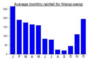
Local Average Monthly Rainfall (mm):
Location
Click on the blue arrow ![]() (top right) to see your current location on the map
(top right) to see your current location on the map
Nice to read some local news reports that confirm hikers have been up this one (for Independence Day in 2022). Not a huge amount of details except that there is a Camp Garuda.
https://potretterkini.id/di-puncak-wawo-lantambaga-sang-merah-putih-berkibar/
https://sorotsultra.com/sorot-berita/dari-puncak-wawo-lantambaga-sang-saka-merah-putih-berkibar-dengan-gagah