
Facts
- Elevation: 1,533 m (5,030 ft)
- Prominence: 1,059 m
- Ribu category:
 Kurang Tinggi
 - Region:
 Peninsular Malaysia /
  Southern Thailand
 - Malaysian state: Perak
- Coordinates: 5.7998, 101.3166
- Rating:
 (Bagged it? Be the first to rate it)
 Loading...
 - Other names: เขาฮูลูติติปาซา in Thai
- World Ribus ID: 68685
Bagging It!
This obscure mountain lies on or very close to the border with Thailand and is the highest summit of the Sankalakhiri Range. It is rarely climbed – in 2013 a group took (or planned to take) 6 days and 5 nights to reach the top and descend again.
Practicalities
-
- Getting there: For Malaysian domestic flights and flights within Southeast Asia, for example to Kuala Lumpur, we recommend Baolau. Penang is the nearest large airport although Kota Bharu is a similar distance away on the opposite coast. Sungai Siput is the closest train station.
- Permits: You can register and pay for an e-Permit online from the Forestry Department of Malaysia website.
- Water sources: Unknown
- We recommend Safety Wing as travel insurance for overseas travellers and tourists hiking up to elevations not exceeding 4500 metres.
Local Average Monthly Rainfall 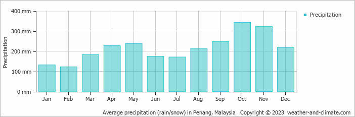
Location
Click on the blue arrow ![]() (top right) to see your current location on the map
(top right) to see your current location on the map