
Facts
- Elevation: 2,457 m (8,061 ft)
- Prominence: 1,800 m
- Ribu category:
 Tinggi Sedang
 - Province:
 Sumatera Utara (North Sumatra)
 - Coordinates: 2.9183, 98.4235
- Rating:

 (15 votes) Add your rating
 Loading...
 - Other names: Sibuaten
- World Ribus ID: 69047
Photos


Bagging It!
This Ribu is the highest in North Sumatra, and overlooks the northern end of Lake Toba. It could be considered the highest point of the remnants of the enormous Toba crater. Despite it’s height, very few hikers explore its wild slopes so it isn’t the easiest one to arrange a guide for. If you ask at your hotel, chances are that most people will look blankly at you and ask if you mean Sibayak or Sinabung! However, persevering is really worth it because once you have found a guide (try in Tongging or kampung Naga Linga at the foot of the mountain) you will be on your way to a truly undervalued and interesting mountain. Although the terrain can be frustrating at times, with countless tiny vines tripping you up and occasional spiny plants and razor-sharp grass, the views over the northern end of Lake Toba are stunning, plus you get to see Sinabung volcano from a different angle. The mountain is also home to a rich diversity of rare plant species, including a sizable number of pitcher plants and wild orchids.
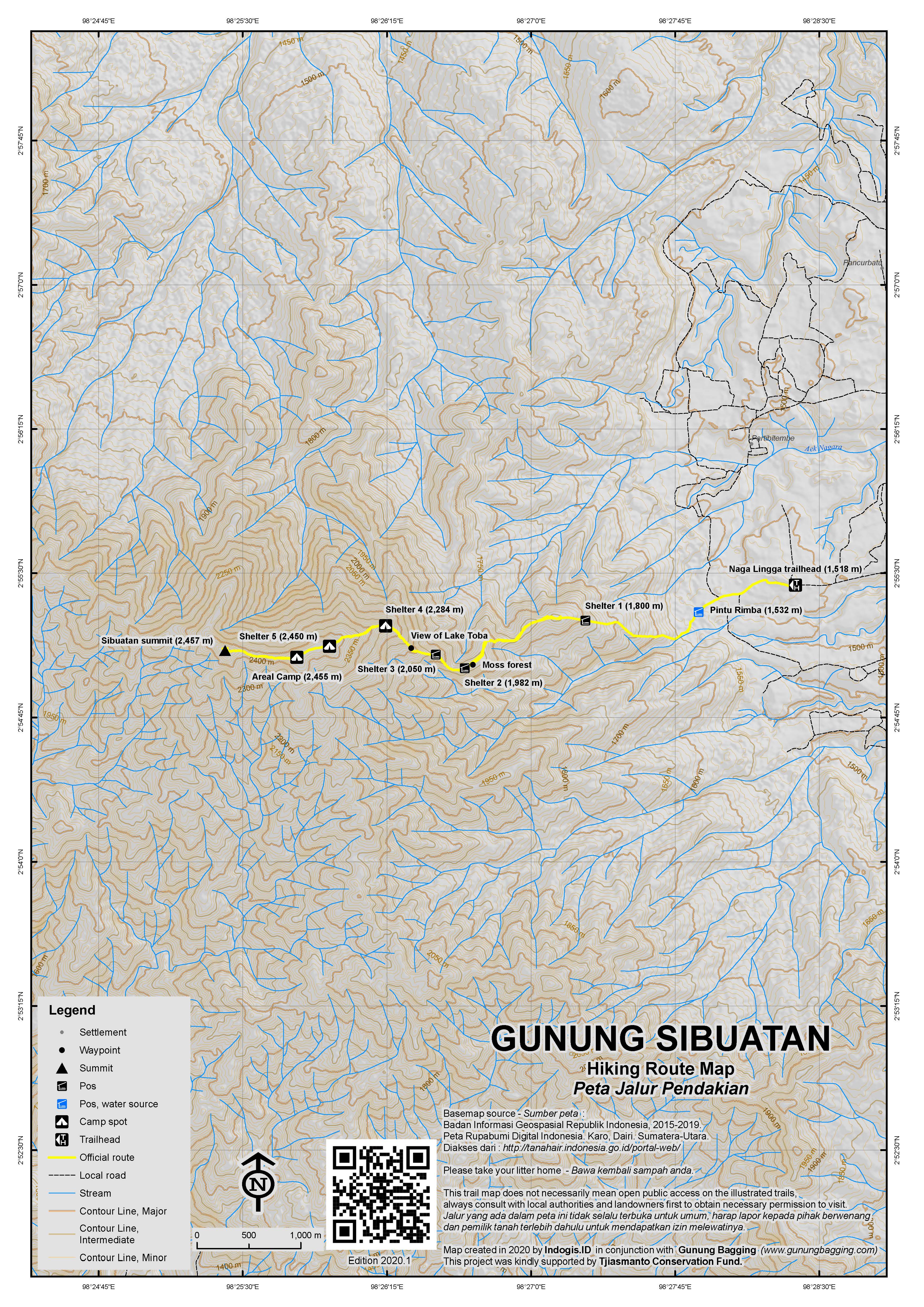
The best approach to the mountain is from the village of Naga Linga, which is just 15 minutes from Merek and at an elevation of 1,518m which means less than 1,000m ascent to the peak. Villagers will probably be surprised to see anyone climbing the mountain – especially foreigners! You really do need a guide for this mountain because it is very easy to get lost, particularly on the lower slopes. A farm track leads towards the mountain past tomato, cabbage and potato crops. At the entrance to the forest (1,532m), about 1km from the village, there are several trails but hopefully your guide will know the correct one to follow. Just a few metres into the jungle is a small river which is the last reliable source of water. The path of the river has been altered with the construction of a small dam by local people, presumably to divert water towards the crop fields.
From here, the trail leads up through forest via Shelter 1 (1,800m) and Shelter 2 (1,982m) and your guide may well need to use a machete to clear the way. Admittedly, this section of the hike is rather tedious but after a couple of hours you will be nearing an elevation of 2,000m. This is where you find yourself on a narrow ridge of small shrubs covered in moss. The vegetation has changed completely. Down to the left is a steep drop into a narrow, deep valley between this and another of Sibuatan’s ridges. To the right you should be able to enjoy a reasonable panorama of farmland below. Looking back down the trail you should begin to catch a glimpse of the huge expanse of water that is Danau Toba, plus Gunung Sipiso-piso to the left of the lake. This mountain is bald except for the very top where there is still a little bit of jungle left. There is a local legend telling of why Gunung Sipiso-piso looks the way it does – with just a small ‘hat’ of forest left on top. Ask your guide if he knows.
The trail at this point is slightly easier to follow, as there is really only one way to go on this ridge – up! From about 2,000m elevation you will begin to see clusters of rare pitcher plants from time to time as you pass via Shelter 3 (2,050m) and Shelter 4 (2,284m) which is a good camp spot. The only other instance that my guide could remember of another foreigner having climbed this mountain was when two Germans came here – over a decade ago – to do some research on the pitcher plants.
As you do battles with the tiny vines that seem to trip you up every couple of minutes, the panorama opens out quite spectacularly. To the right, you should be able to see Sinabung and Sibayak volcanoes near Brastagi and each meter up the mountain improves the view back down towards Lake Toba and Pulau Samosir. The only decent places to camp are all above 2,200m, where there are expanses of flattish areas covered in very low-growing vegetation. This would be a great place for watching sunrise and sunset.
As you get above 2,400m, you enter another section of dense, mossy forest. It is very damp in here. Shelter 5 (2,450m) is soon reached and not long after is the ‘east peak’ or Areal Camp (2,455m). Both are good camp spots. There is no view – just a plateau of mossy forest with a small trail twisting round old branches of stunted trees – but your guide will be able to lead you to a viewpoint just a couple of minutes away from the main trail. This eastern peak is actually just a few metres lower than the true peak, the west peak, which lies another 800 metres to the west. There are a few pieces of string tied to branches by the very occasional party of student hikers from Medan, but in poor weather you will probably need your compass.
It takes about 30 minutes to reach the west peak from the east peak. The trail drops down slightly into another open area of low scrubland before ascending so a rather more shapely peak which is crowned with a cement triangulation pillar with ‘Sec. Triang. No 191’ written on it. This is from Dutch days and marks the true high point of the mountain. Again, there is no view from the true peak of the mountain, but you should congratulate yourself on having bagged a very infrequently climbed mountain. All in all, assuming you did this as a dayhike with small packs, it should have taken you about 5 hours to reach this point.
You can be back down at Naga Linga village in between 3 and 4 hours, including time to pause on the higher slopes to admire the stunning view of Lake Toba, Gunung Sipiso-piso, Sinabung and Sibayak. From Naga Linga it is just 45 minutes back to Tongging, or 20 minutes to the Taman Simalem resort. If staying in Tongging, do call off at the Sipiso-iso waterfall where you can enjoy views down to Tongging and the lake and also take a decent photo of the waterfall with Gunung Sibuatan behind it.
Bagging information by Daniel Quinn (September 2011)
Trail Map
For a high quality PDF version of this and other trail maps, please download from our Trail Maps page.
Practicalities
- Getting there: If you arrive at Kuala Namu airport, take a taxi to Padang Bulan in Medan. You could use the airport train to get into the city first (several times a day, Rp80,000 one way). From Padang Bulan buses run frequently to Brastagi (2 hours) and will only cost Rp 10,000. From Brastagi, take another angkot to Kaban Jahe and change for a third angkot to Merek. Then get an ojek to Naga Linga (or a hotel in Tongging). Bagus Taxis also operate throughout the region so it may be worthwhile getting touch with them to see if they can arrange a convenient drop-off / pick-up rather than having to rely on public transport. There is also a Wingsair flight 3 times a week from Batam to Silanggit which is at the southern end of Lake Toba and may be more convenient.
- Guides and GPS Tracks: Want a PDF version for your phone? Looking for a guide? Need GPS tracks and waypoints? Gunung Sibuatan information pack can be downloaded here.
- Trip planning assistance: Would you like Gunung Bagging to personally help you in arranging your whole trip? Please contact us here.
- Permits: None required but take a photocopy of your passport photo page just incase.
- Water sources: Only reliable at the beginning of the hike at the entrance to the forest where there is a small river. It is best to take sufficient supplies with you.
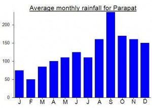
Local Average Monthly Rainfall (mm):
Location
Click on the blue arrow ![]() (top right) to see your current location on the map
(top right) to see your current location on the map
Origins and Meaning
The mountain made by men (Geleng, guide from Brastagi, 2011)
Thanks to this info, I dared myself to climb Gunung Sibuatan on November 23rd-24th 🙂
I started hike late around 4.30pm due to heavy rain with my guide, Nopen (He’s a nice guide!). My trek all the way up and down was raining, muddy and slippery which was more challenging. I tripped many times and fell flat on the face once. It was getting darker and the rain was getting heavier from post 2 to post 3, so we had to make a stop and raised the tent between post 3 and post 4. All night the rain was no sign of stopping until morning.
7am, the rain stopped and we continued to post 5. No view as it was bit foggy but my consolation was the mossy forrest. Almost the same as in Gunung Irau in Malaysia but it was longer, more damp and feels like in another dimension, plus I got to see a ‘saxophone’ like flower 😀
Anyway, I really appreciate Dan, the gunungbagging, for writing this info. It really helped me to describe the situation and how getting there. Thank you!
I climbed Gunung Sibuatan in April 2017.
I started at 4pm and slept at Areal Camp and went to real summit the morning after (7th).
As John Hargreaves said, Gempari did a great job, almost no trash, the track is amazing because the forest is so dense, that the backpack couldn’t pass sometimes. I was very muddy and it rained at the top… no view… no nice pictures. I didn’t cross anyone, no one neither at the posko. It was a tough and spectacular hike. The track is incredible. I thought I was in the middle of Lord of the Rings… lost in a magical forest !
Suggestion: Avoid Sibuatan during rainy/wet period, route going up is a mudfest.
Didn’t know this when I went up in January, did the uptrek in 5hrs through mud. Near the summit was hit by rain, and going back down was a chore. Had to stop for an hour to wait for most of rain to subside. But the way back was worse, mud suspension all the way down from Pos 4.
Left summit slope around 3, reach start of train at 11.
IndonesiA. Indah karna. Alamnya.. Maka dari itu jaga alam ini dgn jiwa kalian, jangan kalian sekali” merusak alam indah ini karna dia menjadi saksi bisu di atas kalian berpijak…
08576599483 salam (K.P.A tenda reot)
Sampah di bawK ke atas….. Ya… Jgn lupa itu pesan. Ku…
Salam (K.P.A tenda reot) LESTARI.
Can someone help with a garmin gdb or gpx file for the track up the mountain. I would like to go up with my gps. If you have a file, it would be most appreciated. David Miller Medan +62 813 6276 1012
Hi David.
Have a look here.
https://www.gunungbagging.com/resources/gps-tracks/
Bear in mind this is from a few years ago and may not be the best route up.
Cheers,
Dan
Thanks Dan, that pointed me in the right direction. Got the file & maybe see u at top of mountain!
Take Rp10,000 for the registration fee and and an identity document to leave at the post. Reportedly, Gempari made 5 rescue outings last year for climbers suffering hypothermia or falls; the muddy sections from Shelter 2 to 4 would be treacherous after heavy rains.
Sibuatan is becoming better known, at least among students from Medan, perhaps even more so since Sinabung has become off limits to hikers.
Since August 2014 Gempari, a cooperative of young people from Naga Lingga, has been registering hikers, checking baggage for potential trash and even fining visitors who fail to bring their trash back down! Their efforts have to be considered worthwhile;. when I went up on Sunday 22nd February, there was not a trace of plastic, paper or metal, even though at least 30 campers had been up top the night before.
Gempari also arrange guides and porters for a moderate Rp300,000 fee for a 2 day/1 night hike, although the trail is now so well-used that a guide is not essential.
The first step is to get to Naga Linga, which is directly on the main road to Sidikalang, 5km past Merek. At the entrance to the village is a turn-off to the right, with a small Gunung Sibuatan sign, and the pos registrasi is right opposite this turn-off. A motorbike can take you up the road 3 km through the coffee and vegetable plantations to the “posko”, which consists of two huts with a large parking space for motorbikes. In fact, the first 2500m are asphalt and there’s talk of paving the rest, which would make the trailhead accessible to cars.
From the posko, the trail follows a stream for 300m to the forest entrance at Pintu Rimba (alt.1530m), the last chance to take on water.
Along the trail, Gempari have marked 5 “shelters” at roughly 1-hour intervals. “Shelter” here means a forest clearing with enough space for a small tent, though only Shelter 5 is flat enough to make a desirable campsite.
Except for a brief steep section after the forest entrance, the trail to Shelter 1 (1800m) is practically a walk in the park- broad, firm, gently sloping and strewn with fallen leaves. Approaching Shelter 2 (1970m), the trail becomes steeper and rougher, with lots of clambering over and under vegetation. Above 2000m, there also some sharp descents mixed in as you pass Shelter 3 (2050m) and Shelter 4 (2300m). At 2400m, the path exits the dwarf montane forest into an area of low scrub with fine views southwest toward Sidikalang and the Dairi Batak region.
Shelter 5 (2450m) is a fine campsite, but the “Areal Camp” (2460m), a couple of minutes further up, would be better in strong winds as it is sheltered by trees. This is effectively the Eastern summit, though our guide did not refer to it as “Puncak Timur”. The place he called Puncak Timur (2420m) is a 10 minute walk east along a narrow but clear path through the undergrowth and is a lookout point with the best sunrise views over Lake Toba, the east and the south.
For sunset views, head to the Western summit, Puncak Barat (2461m by my GPS), which is ostensibly the true summit, though barely a meter higher than the eastern camping area. It’s easily accessible across a saddle in about 20 minutes from the camping area and the trail is now well-defined. The summit itself around the trig pillar is cloaked in trees but there’s a viewpoint a few meters beyond it with views to the west coast and north to the Gunung Leuser National Park in Aceh.
Including rest stops, we took nearly 6 hours for the walk up to the campsite and 4h30 going down.
We saw several pitcher plants, though only those on the summit saddle looked healthy, and no orchids. We did however meet some guys from HIPAS (Sidikalang Nature Lovers Association) who were planting fruit trees to enhance the lower montane forest. Perhaps they will find a way to introduce more orchids too!
For accommodation, there’s a dirty guesthouse in Merek that cannot be recommended. Taman Simalem, just a few km away, looks like a spectacular place but with prices to match. Tongging, overlooked by Mount Sipisopiso and only 30 minutes from Naga Linga, is probably the best option, with half a dozen hotels and fish restaurants by the lake.
If you want to stay in a house in Naga Linga, contact my guide Jansen (081370099609), who was thoroughly competent.
Hi
Do you have any contact information for a guide to take my friend up the mountain and camp on top for one night
🙂
Dari ceritanya indaaaaaaaaahhhhhh x
Kapan y bisa k sana ….
Many thanks to pitcher plant expert Alastair Robinson for identifying the Nepenthes I photographed on this mountain as Nepenthes spectabilis (the speckled one) and Nepenthes tobaica.
Mapagratwa knows this mountain better than others. Coz we are the first team who climb and mapping the route and then continously climb it at least 3 times in a year. We have reach it for 23 times since 1996. All climb journal archived. If you want more information about this mountain, pls visit http://www.mapagratwa.org or call me by phone on +6281260064777 … Tq for interesting to Mt Sibuatan …
Maaf ,, jangan explorer gunung sibuatan, jaga keasriannya dari orang2 yang tidak bertangggung jawab.\
sob ok..
semoga sibuaten akan lestari sampai kiamat nanti,
dan kpada pendaki sejati,
tunjukkan bahawa kau pendaki sejati
bkan malah merusak apa yg ada di dalamnya
”jngan meninggalkan apapun kecuali jejak’
Mapagratwa knows this mountain better than others. Coz we are the first team who climb and mapping the route and then continously climb it at least 3 times in a year. We have reach it for 23 times since 1996. All climb journal archived. If you want more information about this mountain, pls visit http://www.mapagratwa.org or call me by phone on +6281260064777 or +626177710072 … Tq for interesting to Mt Sibuatan …
After coming down from Sibayak and having a good lunch at the guesthouse, I set off to Tongging, a small village on the northern shores of Lake Toba, to enquire about the local Ribu, Gunung Sibuatan, about which not a lot of information is available. It took about 90 minutes in angkots (changing at Kaban Jahe) and then a motorized becak down from the impressive Sipiso-piso waterfall to Tongging village itself. I’d heard good things about the Wisma Sibayak in Tongging from the excellent Wisma Sibayak in Brastagi. It sounded like the guy in charge would be able to help. Unfortunately, when I turned up, the manager was not in and nobody seemed able or willing to help at all. I sat around for 30 minutes until the manager finally appeared. I enquired about rooms (‘don’t know yet, we have a room but the person hasn’t checked out’) and the gunung (‘don’t know, maybe it’s better to ask in Kaban Jahe’). So completely useless really. Although Tongging is a lovely spot and the villagers friendly, I was thinking about getting the hell out of there. Then my luck changed. I tried another place – Roman Sinasi bungalows – and the staff were great and seemed genuinely keen to help. I checked in and wandered down past all the villagers sorting out garlic to the waterfront for some food and a bir bintang. Later on, some locals chaps popped round and said they knew Naga Linga very well and had been up the mountain before. They were willing to be my guides the following but for quite a price. RP 1 million. Given that nobody else knew about the mountain and also that they seemed decent people I agreed, despite the high cost, because it would include chartering an angkot there and back (just a 45 minute journey each way).
The next morning, the old man and his two sons appeared on time and we set off for Naga Linga. The father told me that he had guided a couple of German botanists here many years ago. The trail was tough going – even with 3 guys with machetes it was not easy and so I reckon that we were the first group up Sibuatan for several months at least. The weather was pretty poor on the ascent but it began to improve and we had some great panoramas on the way down. The top got us all confused – after what I had read about the the summit pillar I was searching and searching, expecting it to be closer to the east peak. The two peaks really only are a handful of metres different in height. Finally we found it – success at last – another top 50 Indonesian prominence bagged!
Unfortunately the guides got us a bit lost on the way down and we ended up coming out of the forest about a mile away from the route we used to enter. Not surprising given the confusing terrain and vague if not invisible trail! So take care!
This wild mountain is not easy to recommend to hikers seeking a pleasant experience, but hardcore baggers will probably love it. Some excellent views. For a cheaper way to do things you could try asking the locals in Naga Linga. It can certainly be done as a dayhike but you must get hiking before 9am.
rekan-rekan semua kami akan melakuakn expedition gunung sibuatan yang akan di lakukan pada tanggal 15-17 agustus 2011.jadi apabila anda tertarik ingin bergabung dalam ekspedisi ini silahkan hubungi kami di yahoo masenger “trendmicro.indonesia”
atau di email admin@virusklinik.com
mas, saya mau ke deleng sibuatan. tp tdk ada pemandu. kira2 siapa ya yg bs jd pemandu ?
setahu saya yg paling paham sibuatan adalah mapagratwa politeknik negeri medan … bisa dikatakan sebagai perintis pertama pendakian oleh klub pencinta alam kesana. sejak 1995 tak kurang 35 kali pendakian telah dilakukan mapagratwa. silahkan hubungi saya di 081260064777 atau langsung ke sekretariat organisasi di kampus usu medan.
boleh donk ane di culik kesana.. 😀
muantab gan..
salmek yah gan atas trip nya…
nice info..
kapan2 boleh juga nih menjajakan kaki di puncak Deleng Sibuaten 2457 MDPL
seru bgt perjalannannya…….
NB: Klo ada info lainnya baik ttg Deleng Sibuaten atau Deleng2 lainnya email aja yah gan ke nyoxky@yahoo.com
(salam kenal gan : yogamania)
asyik jg tu…… kpn terakhir kesana mas…. ne cerita pendakian taon brp ya,,,,
semoga keasriaanya tetap lestari sampai 1000 tahun ke depan… !!! semoga kita tahu apa yang kita lakukan…kalo di liat dari sampah + jalur air terjun dwi warna mungkin kita tahu juga berapa lama keasriannya mulai berkurang..??? dan aksi vandalisme tersebut mungkin awal dari berkurangnya keasrian gunung tersebut… meskipun pendakian dan penjelajahan bumi mungkin merupakan kerinduan kita .. thanks
This is the information about Sibuatan. Hope it will be useful for anyone who wants to climb it….
Permadani Hijau Deleng Sibuaten
“Aku pasti ikut!” kataku.
________________________________________
Seorang teman membuat rencana dan persiapan perjalanan ke Deleng Sibuaten. Kebetulan, gunung ini sudah lama menjadi incaran pendakian bagiku. Sibuaten mempunyai keunikan tersendiri dibanding gunung-gunung lain di Sumatera Utara. Alamnya masih asri, vegetasinya khas, jalurnya menantang, ditambah panoramanya yang menawan. Mereka bilang begitu. Aku masih harus membuktikannya.
Gunung (Deleng) Sibuaten adalah salah satu gunung yang berada di sekitar Danau Toba, dan termasuk ke dalam Tumor Toba. Terletak di Kecamatan Merek, Kabupaten Karo, berdasarkan peta topografi keluaran Bakorsurtanal, gunung ini memiliki ketinggian 2.457 meter dari permukaan laut (mdpl).
Dari Medan, kami menuju Desa Naga Lingga, Kecamatan Merek, dengan menumpang sebuah angkutan umum jurusan Medan-Sidikalang. Butuh waktu sekitar 3 jam untuk tiba di desa ini. Setelah membayar ongkos Rp 15.000 per orang, kami pun tiba di Naga Lingga. Tentu saja saya tak perlu menggambarkan lagi pada Anda pemandangan yang sejuk sejak memasuki Kota Berastagi.
Sipiso-piso dan Sibuaten
Desa Naga Lingga adalah desa terdekat dengan rute pendakian yang kami pilih. Ada sekitar 200 kepala keluarga menetap di pemukiman yang berada di sebelah timur laut Gunung Sibuaten ini. Desa Naga Lingga dihuni oleh campuran suku Karo dan Toba yang pada umumnya adalah petani. Dari tatapan mata penduduk, kami yakin kalau mereka belum terbiasa dengan pendaki yang melintasi desanya.
Dari Desa Naga Lingga, kami berjalan sekitar 30 menit menuju pintu rimba dengan menyusuri jalur pedati. Kendaraan tradisional pedati memang alat pengangkutan yang paling efektif untuk lokasi yang kami lewati. Sepanjang jalan menuju pintu rimba, kami dapat menyaksikan dari dekat aktivitas masyarakat di ladangnya. Di antara hamparan kebun sayur-mayur, sesekali terlihat tanaman jeruk dan kopi.
Menuju pintu rimba, aku terkesan dengan bentang alam yang terhampar, dengan Deleng Sipiso-piso di belakang dan Deleng Sibuaten di depan. Deleng adalah sebutan masyarakat sekitar untuk sebuah gunung.
”Ambil saja,” seru seorang wanita setengah baya menawarkan buah tomatnya yang sedang ranum. Dan bukan cuma dia yang menawarkan hasil ladang pada kami sepanjang perjalanan. Orang-orang di sini sangat murah hati.
Pintu rimba Deleng Sibuaten berada pada kaki sebuah bukit kecil yang akan menghantar pendaki ke puncak gunung. Sebuah anak sungai menyambut kami dengan air yang bening. Altimeter menunjukkan ketinggian 1.500 meter dari permukaan laut.
Setelah melakukan orientasi sejenak, kami pun melanjutkan perjalanan. Lebatnya vegetasi hutan segera saja menelan kami di bawahnya. Faisal, temanku, yang sudah pernah sekali ke gunung ini memimpin di depan. Sementara Suban, Yanti, Risna, Tari dan Aku mengekor di belakangnya.
Perang dengan Sipiso-piso
Setelah satu jam berjalan, kami tiba pada ketinggian 1.700 mdpl. Jalan setapak sampai titik ini masih sangat jelas karena sering dilalui penduduk untuk mencari rotan dan berburu. Aku melihat sebuah tempat yang cukup lapang untuk mendirikan tenda dengan anak sungai kecil di sebelahnya. Anak sungai ini adalah sumber air terakhir sebelum ke puncak. Artinya, kami harus membawa persediaan air dari tempat yang biasanya dijadikan camp I ini.
Botol-botol air sudah berisi penuh. Sekarang beban kami berlipat ganda. Rombongan kemudian merayapi punggungan Gunung Sibuaten. Menurut cerita rakyat setempat, deleng ini pernah berperang. Alkisah, pada zaman dahulu kala, Deleng Sibuaten terlibat perselisihan dengan tetangganya, Deleng Sipiso-piso. Dalam peperangan tersebut, Deleng Sibuaten harus kehilangan topinya setelah terkena sabetan pisau Deleng Sipiso-piso. Tak dapat menerima kekalahannya, Deleng Sibuaten mengadu ke Deleng Sibayak yang memiliki semburan api mematikan. Sibayak pun berang dan dengan sekuat tenaga dia menyemburkan apinya hingga membakar Sipiso-piso. Badan Sipiso-piso pun hangus terbakar, kecuali kepalanya. Jadilah Sipiso-piso seperti sekarang, yang hanya punya pepohonan di daerah puncaknya. Sementara, topi Deleng Sibuaten yang terkena sabetan pisau jatuh di daerah Silalahi dan menjadi sebuah gunung kecil.
Kami hanya punya waktu satu malam untuk berakhir pekan di deleng ini. Jadi kami tidak berencana bermalam di camp I. Dari sumber air terakhir, jalur pendakian mulai samar. Maklum, aktivitas hiking ke gunung ini masih terhitung jarang. Faisal tak mau ambil risiko. Dengan rutin ia memelototi peta, kompas dan altimeter. Beberapa kali kami harus mengikatkan tali rapia berwarna kuning pada jalur yang kami anggap rawan, sebagai tanda.
Hutan Lumut, Anggrek dan Kantung Semar
Sekitar 1,5 jam berjalan, kami tiba pada ketinggian sekitar 1.900 mdpl. Di sini, rombongan menyempatkan diri beristirtahat sejenak, menghimpun tenaga untuk melalui jalur yang semakin sulit di depan. Tempat ini terasa sangat lembab. Banyak tanaman lumut menempel pada pepohonan. Pakaian di tubuh kami hampir semua basah oleh butiran air saat harus mengendap-endap di bawahnya.
Dengan nafas yang masih agak memburu, kami melanjutkan perjalanan. Altimeter bergerak berlahan menunjuk angka yang semakin besar. Aku menikmati berbagai jenis tanaman kantung semar (Nepenthes) yang tumbuh di sembarang tempat. Ada yang tumbuh dan tetap di permukaan tanah, tetapi ada juga yang hidup merambat pada pepohonan. Berbagai jenis serangga kecil terjebak pada kantungnya. Sepertinya, tanaman yang sedang naik daun sebagai tanaman hias di Eropa ini tak pernah kurang gizi di hutan Sumatera.
Selain Nephentes sang pemangsa serangga, aku juga menemui beberapa jenis anggrek dengan berbagai ukuran dan warna. Kebanyakan tanaman ini tumbuh menempel pada tanaman lain, tetapi ada juga yang tumbuh di tanah. Sayang, dari kami berenam, tidak ada yang paham tentang jenis-jenis anggrek.
Pada ketinggian sekitar 2.250 mdpl, tim pendaki kembali harus berhenti untuk mengumpulkan tenaga. Kali ini di sebuah tempat yang agak terbuka setelah melewati punggungan yang tipis. Kami telah menempuh medan yang sangat curam dengan vegetasi yang sangat rapat. Sangat sukar menembus jalur yang kadang tidak jelas. Tapi di lokasi peristirahatan ini kami menemukan perubahan pada tumbuhan sekitarnya. Vegetasi mulai terlihat agak seragam, baik dari segi jenis maupun ukurannya. Hanya terdapat beberapa pohon berukuran kecil dengan tanaman perdu-perduan. Walaupun demikian, semua tumbuhan tersebut masih dihiasi lumut pada hampir setiap bagian tubuhnya.
Dari tempat yang agak terbuka, aku dapat menyaksikan lampu-lampu Desa Merek yang mengabarkan senja. Tak banyak waktu yang kami luangkan untuk istirahat. Selain menghemat waktu pendakian, terlalu lama berdiam di hutan lumut ini bisa membuat kami membeku.
Puncak Timur
Hampir pukul 21.00 WIB ketika kami tiba pada ketinggian sekitar 2.380 mdpl. Ini berarti enam jam sudah kami berjalan menyusuri gunung. Lega rasanya setelah melewati hutan lumut. Kini pemandangan didominasi oleh perdu-perduan rendah yang kadang hanya setinggi orang dewasa. Kami semakin dekat dengan puncak.
Biasanya, sebuah pendakian selalu kami akhiri antara pukul 17.00-18.00 WIB untuk menjaga stamina fisik dan kenyamanan perjalanan. Hari ini, kebiasaan tersebut terpaksa dilanggar. Pertama, pada ketinggian 2.050-2.380 mdpl yang telah kami lalui, kondisi medan sangat curam. Hal ini membuat sulit mencari tempat yang datar dan cukup untuk menampung enam orang dalam satu tenda. Selain itu, vegetasinya sangat rapat. Bila kami memaksakan diri membuka tenda, maka beberapa tanaman harus ditebas untuk melapangkan lokasi. Bayangkan bila setiap pendakian melakukan hal ini. Keasrian Deleng Sibuaten akan terganggu.
Alasan kedua, jika terus mendaki meski kondisi jalur kurang jelas dan lambat, setidaknya kami akan terus mengurangi jarak ke puncak. Ketiga, bermalam di hutan lumut ini sepertinya tidak akan membuat tidur kami nyeyak.
Dari ketinggian 2.380 mdpl, tim pendakian terus merangkak berlahan menembus rimbunnya tanaman perdu. Semakin lama, perdu-perduan makin kerdil sampai hanya sebatas lutut orang dewasa. Sekitar 20 menit berjalan, kami akhirnya tiba di sebuah hamparan tanaman perdu yang cukup luas. Di tempat terbuka ini, perdu tak lebih tinggi dari batas pinggang. Altimeter menunjukkan ketinggian 2.439 mdpl. Ini berarti kami sudah sampai di puncak timur Deleng Sibuaten.
Menurut perhitungan, hanya butuh sekitar 45 menit dari sini ke puncak 2.457 mdpl. Kami memutuskan menginap di sini, mengingat kondisi fisik yang sangat letih. Udara dingin segera saja menusuk tulang.
Menara Pemantau
Keesokan harinya, pagi sekali, kami sudah melepas sleeping bag. Tidak ada pendaki yang mau kehilangan indahnya sunrise di Deleng Sibuaten. Apalagi cuaca cukup baik pagi ini. Nun jauh di ufuk timur, di balik pegunungan yang membalut Danau Toba, matahari pagi muncul perlahan-lahan seperti kehadiran maharaja menuju tahta. Kicauan burung menyambut seperti ritual bumi yang paling kekal. Terasa sangat dramatis di sini.
Sembari menyiapkan sarapan, aku tak henti-hentinya kagum dengan apa yang kami saksikan. Ekosistem Sibuaten memang masih asri. Harus kuakui. Di sebelah timur, sisi barat Danau Toba dan Pulau Samosir meremang di sela-sela kabut pagi. Di sebelah utara, Gunung Sinabung dan Sibayak menyapa siang seperti dua raksasa buncit yang malas. Sementara di sisi selatan, lampu-lampu Kota Sidikalang tampak semakin redup sampai akhirnya padam sama sekali. Kehidupan dimulai lagi.
Hanya pemandangan ke sisi barat gunung yang tidak dapat disaksikan dari Puncak Timur. Di sana, Puncak Barat memblok mata seraya menyembunyikan satu lagi panorama yang akan menjadi tujuan akhir kami. ”Seperti menara pemantau saja!” ujar Tari.
Pukul 08.30 WIB, setelah sarapan, kami bergegas meninggalkan Puncak Timur. Lalu menyusuri sebuah punggungan kecil menuju Puncak Barat. Jalan menuju puncak ini melalui sedikit hutan lumut dengan pepohonan yang tidak terlalu tinggi. Sepanjang itu, kami kembali menjumpai berbagai jenis kantung semar dan anggrek liar. Dan menjelang Puncak Barat, setelah sekitar 30 menit berjalan, tanaman perdu yang cukup rendah kembali menggantikan vegetasi sebelumnya. Panorama dari tempat ini tak kalah menarik, ditambah jurang di sebelah kiri kanan. Aku merasa seperti berada di atas kehidupan beralaskan permadani hijau.
Sekitar 45 menit berjalan turun naik, akhirnya kami tiba di puncak Deleng Sibuaten yang sebenarnya. Sebuah pilar beton bertuliskan SEC TRIANG No. 191 setinggi kurang lebih 1,5 meter menyambut siapa saja yang menjejakkan kaki di sini. Pilar ini merupakan tanda triangulasi dengan ketinggian 2.457 mdpl. Vegetasi di sekitar pilar hanya pepohonan kecil yang cenderung homogen. Dari tempat ini, kami dapat menyaksikan bentangan hutan yang masih sangat hijau di bawah sana. Entah sampai kapan bentangan itu bertahan sebagai permadani hijau.
Walau jauh terpencil, tapi pilar Gunung Sibuaten tak luput jua dari aksi vandalisme. ”Makumba” tertulis dengan sengaja pada pilar itu. Entah apa artinya.
Kami berpose bersama di dekat pilar. Bagi pendaki sejati, akan lebih baik menunjukkan selembar foto dari pada membawa turun setangkai bunga anggrek dari gunung. Selesai mengumpulkan sampah bekas makanan kaleng pendaki terdahulu, kami pun bergegas turun. Satu harapan telah kutinggalkan di puncak. ”Tuhan, pertahankanlah keasrian Gunung Sibuaten dari tangan-tangan tak bertanggung jawab. Itupun bila Engkau masih mau mendengarkan permohonan kami”.
Below is a Google Translate… I’m going to climb this one in April – the account doesn’t exactly explain how long it takes to ascend/descend but I imagine a night climb in time to reach the summit for dawn will be fine. If anyone has a HP number for a guide in the area, please make another comment.
A friend made a plan and preparation for a trip to Deleng Sibuaten. Incidentally, this mountain has long been the target of climbing for me. Sibuaten have unique characteristics compared to other mountains in North Sumatra. Nature is still beautiful, unique vegetation, challenging track, plus a view is captivating. They said so. I still have to prove it.
Mountain (Deleng) Sibuaten is one of the mountains around Lake Toba, and belong to the Tumor Toba. Located in the District Brand, Karo District, based on topographic maps Bakorsurtanal output, this mountain has a height of 2457 meters above sea level (masl).
From Medan, we headed to the village of Naga Linga, District of Marks, with boarded a public transport route Medan-Sidikalang. It took about 3 hours to arrive in this village. After paying the fare of Rp 15,000 per person, we arrived at the Naga Linga. Of course I do not need to describe again in your views of a cool since entering the city of Berastagi.
Sipiso-piso and Sibuaten
Linga Dragon Village is the village closest to the ascent route we chose. There are about 200 heads of families living in settlements located in the northeast of Mount Sibuaten this. Naga Linga village inhabited by a mixture of Karo and Toba tribes who generally are farmers. From the eyes of the population, we believe that they are not familiar with climbers who crossed his village.
From the village of Naga Linga, we walked about 30 minutes into the jungle with the door down the cart path. Traditional vehicle transportation carts are the most effective tool for the location we passed. Along the way to the door of the jungle, we can see from the close community activities at his farm. Among the vegetable plot, occasionally visible orange and coffee crops.
Towards the door of the jungle, I was impressed with the landscape that spread out, with Deleng Sipiso-piso Deleng Sibuaten behind and in front. Deleng is the name for a mountain community.
“Take it,” exclaimed a middle-aged woman offering fruit was ripe tomatoes. And not only he who offers the results of the field on us the whole way. The people here are very generous.
Doors jungle Deleng Sibuaten are at the foot of a small hill that will be brought to the top of the mountain climbers. A tributary welcomed us with clear water. Altimeter indicates altitude of 1,500 meters above sea level.
After conducting the orientation for a moment, we continue the journey. Thick forest vegetation soon swallow us underneath. Faisal, my friend, who had once led to this mountain in front. While Suban, Yanti, Risna, Dance and I’m lagging behind.
War with Sipiso-piso
After an hour of walking, we arrived at an altitude of 1700 masl. The path to this point is still very unclear because residents frequently traveled to look for rattan and hunting. I saw a place that is roomy enough to set up a tent with a small creek next to it. This tributary is the last water source before the summit. That is, we should bring supplies of water which is usually used as a camp where I was.
Water bottles are filled. Now we load doubled. The delegation then crawl Sibuaten Mountain ridge. According to local folklore, this deleng ever fought. Once, in ancient times, Deleng Sibuaten involved disputes with neighbors, Deleng Sipiso-piso. In war, Deleng Sibuaten have lost his hat after exposure sabetan Deleng Sipiso knife-piso. Unable to accept defeat, Deleng Sibuaten complained to Deleng Sibayak a deadly burst of fire. Sibayak was furious and he forcefully spewing flames to burn Sipiso-piso. Body-piso Sipiso was burned, except for his head. Be Sipiso-piso like now, which only had the trees in the area of peak. Meanwhile, hats Deleng affected Sibuaten sabetan knife fell on the area Silalahi and become a small mountain.
We only have one night for a weekend in this deleng. So we do not plan to spend the night at Camp I. From last spring, began climbing lane vague. Understandably, the activity of hiking to the mountain is still counted rare. Faisal took no chances. With the routine he glared at a map, compass and altimeter. Several times we had tied a yellow rope rapia the path that we think is vulnerable, as a sign.
Forest Moss, Orchid and Pouch Semar
About 1.5 hours walking, we arrived at an altitude of about 1900 masl. Here, the group took a moment beristirtahat, gather energy to go through the more difficult path ahead. This place was very damp. Many plants moss attached to the trees. Apparel in our bodies virtually all wet by water droplets when it comes to sneaking underneath.
With the breath that is still rather hunt, we continue the journey. Altimeter move berlahan appoint greater numbers. I enjoy a wide variety of plants semar sac (Nepenthes) that grow in any place. There is a growing and remains at ground level, but there is also a living vine on trees. Various types of small insects trapped in pockets. Apparently, plants that are on the rise as an ornamental plant in Europe has never been malnourished in the forests of Sumatra.
In addition to the predatory insect Nephentes, I also encountered several species of orchids in various sizes and colors. Most of these plants grow attached to other plants, but there is also growing in soil. Unfortunately, the six of us, nothing is understood about the types of orchids.
At an altitude of about 2250 meters above sea level, the team must stop climbers returned to collect energy. This time in a place that is slightly open after passing through a thin ridge. We have been through very steep terrain with very dense vegetation. It is very difficult to penetrate the lane which sometimes is not clear. But the location of this resort we found changes in the surrounding vegetation. Vegetation began to look rather uniform, both in terms of type and size. There are only a few small trees to plant shrubs-perduan. Nevertheless, all the plants are still decorated with moss on almost every part of her body.
From a slightly open, I can see the lights of the village who were preaching Brand dusk. Not much time we spend for the rest. Besides saving time climbing, prolonged stay in the forest moss can make us frozen.
East Peak
Almost at 21.00 pm when we arrived at an altitude of about 2380 masl. This means that six hours had we walked down the mountain. It was a relief after going through moss forest. Now the landscape is dominated by low shrubs-perduan are sometimes just as high as adults. We are getting closer to the peak.
Typically, an ascent we always end between the hours of 17:00 to 18:00 pm to maintain physical stamina and comfort of travel. Today, that habit had been violated. First, at an altitude of 2050-2380 masl we’ve been through, the terrain is very steep. This makes it difficult to find a flat and large enough to accommodate six people in one tent. In addition, the vegetation is very dense. If we force ourselves to open the tent, then a few plants should be cut down to clear the site. Imagine if every ascent to do this. Keasrian Deleng Sibuaten will be disrupted.
The second reason, if it continues to climb even though the path is less clear and slow, at least we will continue to reduce the distance to the summit. Third, spend the night in the forest moss is likely not going to make us sleep nyeyak.
From a height of 2380 meters above sea level, climbing team continues to crawl berlahan penetrate thick clump of plants. The longer, the dwarf shrub-perduan until only the adult knee. About 20 minutes walking, we finally arrived in a stretch of a fairly large clump of plants. In this open space, shrubs no higher than the waist. Altimeter indicates altitude of 2439 masl. This means we’ve reached the top of the east Deleng Sibuaten.
According to calculations, only took about 45 minutes from here to a peak of 2457 meters above sea level. We decided to stay here, considering the physical condition is very tired. Cold air soon pierced the bone.
Observation Tower
The next day, morning, we had taken off sleeping bag. No climbers who want to lose a beautiful sunrise in Deleng Sibuaten. Especially good weather this morning. Deep in the eastern horizon, beyond the mountains that bind Lake Toba, the morning sun appears slowly toward the throne as emperor’s presence. Birds chirp like a ritual to welcome the most immortal earth. It felt very dramatic here.
While preparing breakfast, I’m endlessly fascinated by what we witnessed. Sibuaten ecosystem is still beautiful. I must admit. In the east, the west side of Lake Toba and Samosir Island bristle on the sidelines of the morning mist. To the north, and Sibayak Sinabung greet the day like two giant bloated lazy. While on the south side, city lights Sidikalang looking increasingly dim until finally extinguished altogether. Life begins again.
Only a view to the west side of the mountain that can not be seen from the East Peak. There, West Peak blocking one another’s eyes as he hid a panorama that will be our final destination. “As observers tower alone!” Says Dance.
At 08.30 am, after breakfast, we hurried to leave the East Peak. Then along a small ridge to the West Peak. The road to the top of this through a little moss forest with trees that are not too high. Throughout, we re-encounter various kinds of bags semar and wild orchids. And ahead of West Peak, after approximately 30 minutes walk, plant low shrubs back enough to replace the previous vegetation. Panorama of this place is not less interesting, plus the gap in left-right. I felt like we were on life paved with green carpet.
About 45 minutes walk down ride, we finally reached the top Deleng Sibuaten the truth. A concrete pillar marked the SEC TRIANG No. 191 approximately 1.5 meters tall welcome anyone who set foot here. This is a sign of triangulation pillars with a height of 2457 masl. Vegetation around the pillar only small trees which tend to be homogeneous. From this place, we can see a stretch of forest that is still very green down there. I do not know how long it lasts a stretch of green carpet.
Although far remote, but the pillars of Mount Sibuaten likewise not spared from vandalism. “Makumba” deliberately written in the column. I do not know what it means.
We are posing together near the pillar. For a true climber, will better show a photograph of the orchid flower to bring down from the mountain. Finish collecting garbage cans of food used previous climbers, we were rushing down. One hope was left at the top. “Lord, Keep the beauty of Mount Sibuaten from the hands of irresponsible. And that’s if you still want to listen to our request. “
asyik trek nya nih,, kapan2 temani kami naik ya, mas.. 🙂