
Facts
- Elevation: 986 m (3,235 ft)
- Prominence: 986 m
- Peak category:
 Spesial
 - Province:
 Nusa Tenggara Timur
 - Coordinates: -8.3000, 124.3500
- Rating:


 (6 votes) Add your rating
 Loading...
 - Other names: Known as ‘Maru’ by villagers and Dol Karambahi on the Bakosurtanal map.
Photos


Bagging It!
Pulau Pura is a small volcano cone island which is sparsely populated and lies between the larger islands of Pantar and Alor.
I climbed Gunung Pura in June 2009 on the way across Nusa Tenggara from Lombok to Alor.
I started from La Petite Kepa (www.la-petite-kepa.com), which is a great place to dive or just relax and run by a French couple. It is based on Pulau Kepa, a small island just off of Alor Kecil on the west coast of Alor and about 30 mins bus ride from Kalabahi. The owners organised a boat to take me from there to Pura island at 6am and the trip took about 30 minutes to the small village on the northwest coast (Desa Pura Utara). My arrival was greeted by much interest from the locals as tourists rarely venture here, and I was quickly able to find a guide to take me up the mountain, which locals call ‘Maru’, for around Rp50,000.
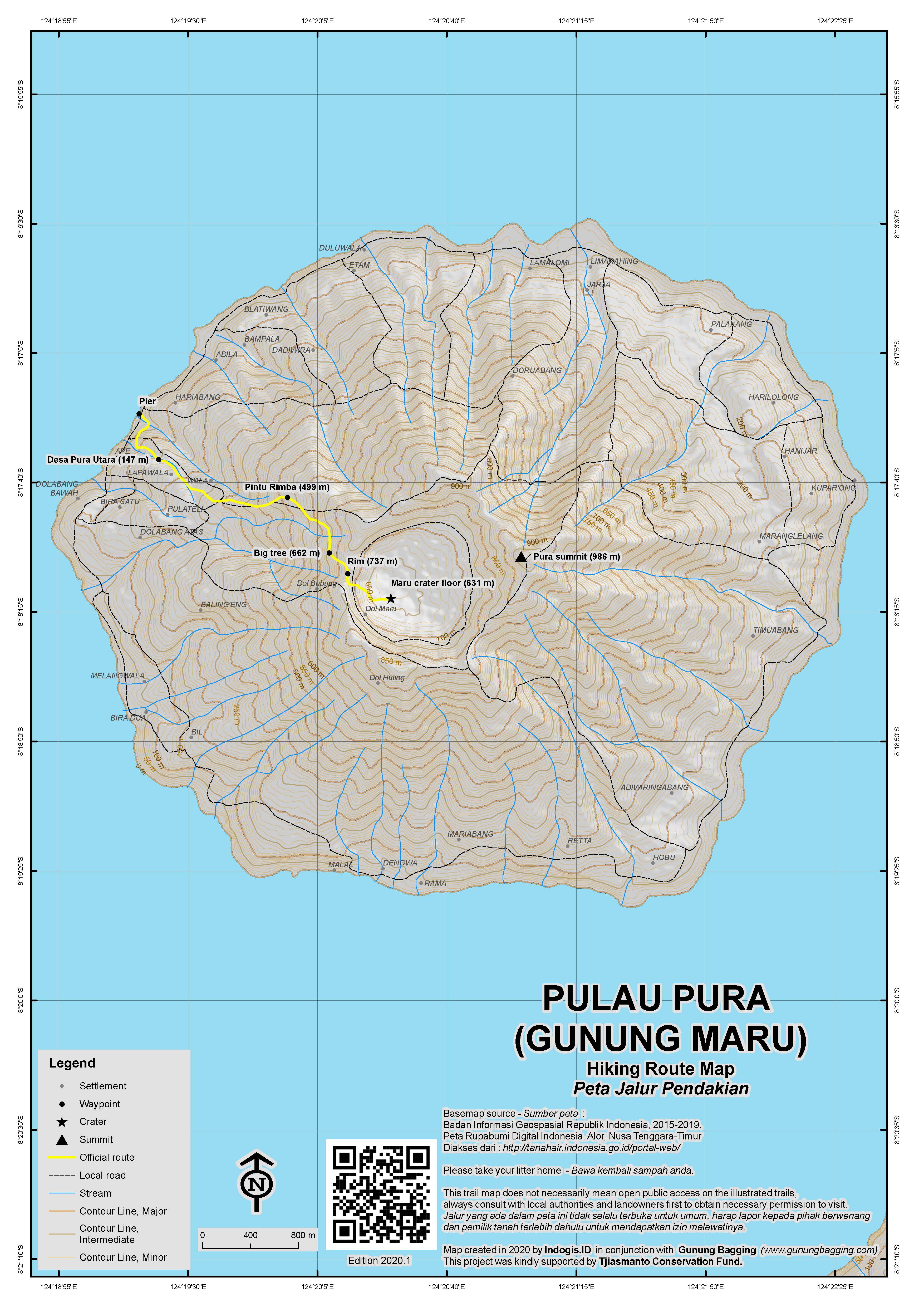
The ascent is not too tricky with a reasonable path all the way up to the crater rim, although it is fairly steep once you get past the small village (elevation 147m) about 15 or 20 minutes from the main coast. It took me about 2 hours with frequent stops to catch my breath. The guide and I were accompanied by his three children, who gleefully bounded up the mountain with little effort whilst I puffed and panted along behind them. The trail is fairly open for the first third and provides great views of Alor, Pantar (including the beautiful pyramid-like top of nearby Gunung Tuntuli and, higher up, of Sirung in the distance) and surrounding islands. Once you get nearer the top the views become obscured by the forest (entered at 499m), but thankfully this gives some shade from the sun.
Once at the top we walked around the rim (elevation 737m at the col) for about half an hour and then descended into the Maru crater itself, which took about another 30 minutes. The crater is heavily forested on the descent but is more open in the middle, with a few small farms and scattered huts (elevation 631m on the crater floor). Ascending to the true highest point of the rim – which lies on the far side – may be possible but is undertaken rarely if at all. On the way back we stopped at the guide’s village where I was given food and tuak and spoke in broken Indonesian with the locals who were very friendly.
The ascent can be done fairly easily in half a day starting from La Petite Kepa. You will need some basic Indonesian as no English is spoken on the island other than the ubiquitous “Hello Mister”. The view from the rim is mostly obscured due to the forest, nevertheless it is a worthwhile trip and a delight to meet such friendly, generous and happy people.
Bagging information by Matthew Riley (October 2011), updated by Dan Quinn (September 2019)
UPDATE on elevation: The Bakosurtanal map for the area suggests the highest peak is called Dol Karambahi and only 986 metres high (and therefore not a Ribu). Gunung Maru is listed as the crater base at 624m rather than a higher peak on the forested rim. The Bako map shows several trails including one over Dol Karambahi but these trails are quickly overgrown if not used frequently. Other sources suggest the highest peak is over 1,000m (including once source which probably overestimates a fair bit with 1,036m). A trip to the top with a GPS may make things clearer! For now, it appears to miss out on Ribu status by a handful of metres.
Trail Map
For a high quality PDF version of this and other trail maps, please download from our Trail Maps page.
Practicalities
- Getting there: A 50 minute boat ride from Alor Kecil, which is 30 minutes by ojek from Kalabahi.
- Guides and GPS Tracks: Want a PDF version for your phone? Looking for a guide? Need GPS tracks and waypoints? Gunung Maru information pack can be downloaded here.
- Permits: Not required.
- Water sources: Take sufficient supplies with you as there are no water sources on the trail until you get down to the crater floor. However, you might be able to get your guide to climb a tree and bring down some kelapa muda (young coconut juice) on the lower slopes.
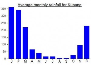
Local Average Monthly Rainfall (mm):
Location
Click on the blue arrow ![]() (top right) to see your current location on the map
(top right) to see your current location on the map
This was the first peak me and Nick Hughes climbed on our trip heading east-west from Alor to Flores.
We flew in to tiny Mali airport, Kalabahi, Alor, from Kupang (daily flights – good view of Pura on the left side of the aircraft) and got ojeks into Kalabahi town for about Rp30,000 each – about 30 or 40 minute journey. A very pleasant road along the coast.
After having been told by the French people who run La Petite Kepa that they could not guarantee accommodation until the day before, we decided to simply stay in town. The Hotel Adi Dharma (Rp80-140,000) was basic but right next to the picturesque harbour from where, in clear conditions, you can see Pura and sometimes even Sirung behind.
Two things to do in Kalabahi are to visit the museum with the local drums (this is closed both sdaturday and sunday however!) and see the popcorn stall at the market and witness the large bomb-like bang as the corn pops inside a very primitive piece of ancient equipment!
I also bought some Marungga leaves (known as Marungge in Flores and ‘Moringa’ in English) after Nick told me his wife said it was a cure-all plant full of vitamins. All the old women at the market kept laughing at me, with it sticking out of the back of my rucksack, and asking ‘Mister like Marungga?’. It was later that I discovered that the leaves are often devoured by local women wishing to become pregnant or to produce more breast milk.
First thing the following morning we got ojeks down to the little harbour at Alor Kecil (30min, Rp20,000) to meet Pak Sere (0813 3849 4703) the boatman to take us over to Pura and then onward to the south coast of Pantar to climb Sirung. Whole cost was Rp800,000 for the day. Just for Pura you could probably get it for around Rp300 or 400,000 as it’s only 6 kilometres or so.
We were let off at a tiny pier on the north side of the island where we simply followed the very nice, wide track up to the village of Desa Pura Utara (about 20 minutes or so, great views, especially of Tuntuli on Pantar island). With it being Sunday (Church day on this predominantly Christian island) it took almost 5 minutes to get a guide for the hike. Other days it would take even less! The chap’s young son followed us up the mountain too, in bare feet of course. The locals call it ‘Maru’, but whether this refers to the crater floor which is inhabited (most likely in my opinion), or the rim, or is just the local word for mountain, is unclear.
The locals seem very keen on drinking the local palm wine, which was offered to us at 7am! We saw a couple of chaps halfway up the trees collecting the stuff!
The first part of the trail onwards from the village leads through Cashew and and Teak plantations but there are still regular views of the ocean down below. It was pretty shady and relatively cool when we did it, since the sun was not directly on us. Best start as early as you can. The views further up, of Sirung in the distance, are superb.
From the crater rim at 735m, the trail down to the crater itself leads through bamboo and there are lots of spiky plants about so take care where you put your hands. We reached one hut, and then a second, larger one, where we rested a while. As it was Sunday, the people who live here during the week, had gone down to the villages so it was empty, apart from us and a pig or two. Vanilla grows here in the crater, and there are a cluster of coconut trees too. Very pleasant location and temperature.
Our guide had never been to the highest part of the rim, which is on the far side of the crater, and it does look very dense indeed. Your best bet would be to ask one of the few who does live up here (so if that is your aim, don’t visit on a Sunday). We paid our guide Rp100,000 and it took up about 5 hours for the round trip including a couple of rests.
Is it definitely over 1,000m in elevation, and therefore a Ribu? Difficult to say, pretty close in my opinion. Given we were at 640m on the crater floor, if I had to guess I would say it falls just short of the magic 1000, but until we have definitive proof one way or the other if will remain on the Ribu list. Alas, we didn’t have time anyway as Pak Sere was waiting for us to take us over to Pantar.