
Facts
- Elevation: 1,964 m (6,444 ft)
- Prominence: 990 m
- Peak category:
 Spesial
 - Province:
 Lampung
 - Coordinates: -4.9758, 103.8600
- Rating:
 (Bagged it? Be the first to rate it)
 Loading...
 - World Ribus ID: 69228
Photos


Bagging It!
Unknown at present. According to the Bakosurtanal map, the summit features the triangulation pillar P.76.
Practicalities
- Getting there: There are regular buses from Bandar Lampung (Rajabasa terminal) to Liwa (where you can change) and one bus per day direct to Ranau. There is even a bus all the way from Jakarta. There are also plenty of buses from Palembang via Batu Raja. If driving, if can take from between 6 to 8 hours to reach Danau Ranau from both Palembang and Bandar Lampung.
- Permits: Unknown.
- Water sources: Unknown.
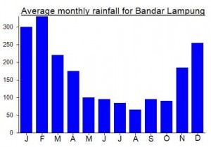
Local Average Monthly Rainfall (mm):
Location
Click on the blue arrow ![]() (top right) to see your current location on the map
(top right) to see your current location on the map
Hi Dan
I am keen to try and climb Gunung Pugung..Lampungdo you have.any idea about a local guide in the Area?
Cheers Lawrence
Been there, but not the peak. You can start climbing fro Sukabanjar. Ask around the village for local guide, perhaps some ex-illegal logger would agree to guide you there. The trail is a narrow ridge to the top. Water is not available when you already on the ridge towards the peak. A friend of mine has to squeeze water from mosses for drinking.