
Facts
- Elevation: 2,078 m (6,818 ft)
- Prominence: 983 m
- Peak category:
 Spesial
 - Province:
 Sumatera Selatan (South Sumatra)
 - Coordinates: -3.3382, 102.6218
- Rating:

 (2 votes) Add your rating
 Loading...
 - Other names: Labelled ‘Bukit Condong’ on the Bakosurtanal map.
Photos
")
")
")
")
")
")
Bagging It!
This range is clearly visible from Bukit Kaba and has at least two peaks over 2,000m in elevation. The more southerly one – a flat topped peak – is labelled Bukit Kelam on the Bakosurtanal map with an elevation of 2,060m. The more northerly and sharper peak is listed at Bukit Condong with an elevation of 2,063m though it is probably a little bit higher than that.
Practicalities
-
- Getting there: Unknown
- Permits: Unknown
- Water sources: Unknown
Local Average Monthly Rainfall (mm): 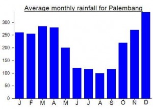
Location
Click on the blue arrow ![]() (top right) to see your current location on the map
(top right) to see your current location on the map