
Facts
- Elevation: 1,516 m (4,974 ft)
- Prominence: 1,139 m
- Ribu category:
 Kurang Tinggi
 - Province:
 Kalimantan Timur (East Kalimantan)
 - Coordinates: 2.0533, 116.6325
- Rating:

 (3 votes) Add your rating
 Loading...
 - Other names: Guguang, Gay
- World Ribus ID: 69159
Photos
")
Bagging It!
According to Nepenthes expert Alastair Robinson, the mountain is ‘called Gunung Guguang or Gunung Gay depending on who you talk to. There are two adjacent peaks in the area, and the maps call the highest one Guguang, but the Dayaks there call it Gay, and vice versa for the other peak. It’s a beautiful area, punctuated only by logging roads and the odd Dayak village. I went alone, which made it horrifically expensive, but if I ever return, I’ll try to get in via perahu instead of jeep. They really sting you for petrol in Berau, whether or not you speak Bahasa.’ According to the low-quality Bakosurtanal map for the region, Gunung Gay is 1,448m (1,461 according to SRTM) and Gunung Guguang is 1,253m (with a south-eastern peak just a metre lower at 1,252m). In 2020, we discovered that a peak in the far west of the range was higher than Gunung Gay – Gunung Kongpas (1,468m) according to the Bakosurtanal map, but almost certainly over 1,500 metres according to SRTM data. This is even harder to get to than Guguang or Gay. Gay remains pretty prominent with 758m despite being part of the same large range.
Practicalities
-
- Getting there: Berau is the closest airport.
- Permits: Take a photocopy of your passport photo page just incase.
- Water sources: Unknown
Local Average Monthly Rainfall (mm): 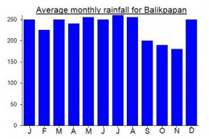
Location
Click on the blue arrow ![]() (top right) to see your current location on the map
(top right) to see your current location on the map
Ada yg pernah kesana…. Apakah ada yg bisa bantu saya kesana..?.. Mohon infonya yg bisa saya hubungi…
Rencana saya mau kesana bang