
Facts
- Elevation: 1,063 m (3,488 ft)
- Prominence: 1,063 m
- Ribu category:
 Kurang Tinggi
 - Province:
 Sulawesi Tenggara (Southeast Sulawesi)
 - Island: Butung
- Coordinates: -4.4866, 122.9699
- Rating:
 (1 votes) Add your rating
 Loading...
 - Other names: Kabawo Wani
- World Ribus ID: 69189
Bagging It!
This is the highest point on the island of Buton/Butung and may be best known as Kabawo Wani. Published elevations of 1,190m seem unlikely – probably under 1,100m. The Bakosurtanal map suggests a height of 1,063m and lists a lower peak around 2 kilometres to the north-east as being called Kabawo Wani with a heigh of 778m, which is probably the source of the name ‘Gunung Wani’. It is a karst mountain and home to rare Anoa cattle.
Practicalities
-
- Getting there: As this is in the north of the island, probably better getting a boat over from Sulawesi mainland than heading overland all the way up from Bau Bau. The trail apparently starts in Labuan near the north coast. Via Kendari city to the Amolengo (Kolono) ferry port (approximately 2 hours) then cross the Buton Strait by ferry to Labuan (45 minutes). Then head to Labuan Village which is the starting point of the climb.
- Accommodation: Unknown, presume village accommodation is available on an informal basis.
- Permits: Available from Labuan Village and North Wakorumba Police in Labuan
- Water sources: A small river near to the trail.
Local Average Monthly Rainfall (mm): 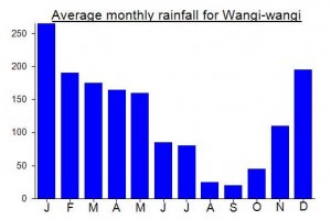
Location
Click on the blue arrow ![]() (top right) to see your current location on the map
(top right) to see your current location on the map
Bagi mereka yang ingin berkunjung atau mendaki Gunung Kabawo Lahambogo/Wani ini bisa mendapatkan fasilitas penginapan (akomodasi) dan rumah makan sekitar kawasan Pelabuhan Labuan, lengkap dengan wifi dan jaringan seluler. Ada Penginapan Ipul Jaya, As Sakinah dan Penginapan Vortuna.
Titik Tertinggi di pulau Buton tertulis Kabawo Lambohogo (1.063 mdpl) di peta keluaran Bakosurtanal/BIG tahun 1992, yang sebenarnya bernama Kabawo Wani menurut Tokoh Masyarakat Labuan. BIG mengakui bahwa banyak toponim yg perlu di koreksi melalui program survey toponim di Wilayah Sulawesi Tenggara sekitar tahun 2015. Termasuk penamaan titik tertinggi pulau buton sudah sepatutnya dikembalikan ke nama sebenarnya yaitu dari Kabawo Lambohogo menjadi Kabawo Wani.
Thanks for the useful comment. Is Kabawo Wani definitely the highest point? Sometimes there can be a mix-up between locations, not just names… are you sure Kabawo Wani is not the name of a similar but slightly lower peak? If you have a GPS track then let me know. Terima kasih.
Puncak Tertinggi di Pulau Buton ini dapat terlihat jelas dari Kelurahan Labuan dan dari pelabuhan fery Labuan. Tahun 2012 kami melakukan survey pada kawasan tersebut. Kami mendiskusikan bersama masyakat serta pemerintah setempat dan mengkoreksinya dengan menggunakan peta dan kompas. Dari diskusi tersebut masyarakat mengatakan bahwa gunung yang terlihat dari tempat tinggal mereka sambil menunjuk ke arah gunung itu (Kabawo Lahambogo) adalah Gunung Wani dan karena Gunung Wani tersebut mempunyai cerita rakyat setempat. Selain itu berdasarkan pengalaman kami bahwa peta topografi skala 1 : 50.000 yang bersumber dari Bakosurtanal atau BIG ini memiliki toponim atau nama tempat yang berbeda versi dengan masyarakat lokal. Koordinat titik Puncak adalah 122° 58′ 08″ Bujur Timur dan 04° 29′ 30″ Lintang Selatan. Terima kasih
untuk mendaki Gunung Wani dapat melalui Kota Kendari dengan kendaraan roda 4 atau roda 2 menuju pelabuhan fery Amolengo (kolono) dgn jarak tempuh kurang lebih 2 jam, kemudian melintasi Selat Buton dengan kapal fery menuju Labuan selama 45menit. Kemudian menuju Desa Labuan yang merupakan titik awal pendakian. Untuk perizinan dapat melalui pemerintah Lokal yaitu Desa Labuan dan Polsek Wakorumba Utara di Labuan. Sumber air saat pendakian yaitu sungai kecil sepanjang pendakian atau menadah air hujan
Pada peta topografi keluaran BIG tertulis Kabawo Lahambogo yang sebenarnya adalah Kabawo Wani (1063m). Kami telah melakukan survey tahun 2003 di sekitar Labuan terhadap warga disana. Mereka mengatakan bahwa gunung tertinggi adalah Kabawo Wani. Kami juga telah naik sampai ke puncak Wani dari Labuan di tahun tersebut. Gunung Wani termasuk gunung kars yang masih alami. Vegetasi masih rapat dan rumah bagi Anoa (sapi hutan Sulawesi) dataran rendah