
Facts
- Elevation: 1,351 m (4,432 ft)
- Prominence: 949 m
- Peak category:
 Spesial
 - Province:
 Sulawesi Utara (North Sulawesi)
 - Coordinates: 1.4854, 125.1583
- Rating:

 (1 votes) Add your rating
 Loading...
Photos


Bagging It!
Dua Saudara is the highest mountain in the area to the east of Gunung Klabat in North Sulawesi. There are actually three main peaks that give their names to the Tangkoko-Batuangus-Dua Saudara National Park area. Despite its impressive stature, Dua Saudara is rarely climbed and the only information we currently have is that a route may be possible from the Bitung side.
Tangkoko is the northeastern-most volcano on the island of Sulawesi and lies about 3km northeast of Dua Saudara. It has a large deep crater which is today populated with numerous rare species of animal and plant. Back in 1801, the crater contained a cone surrounded by lake water. At this time, the a new flat-topped lava dome emerged. This was named Batuangus (literally ‘burnt rock’) and was the source of later volcanic activity (most recently in 1880). The nature reserve was created in 1942 by the Dutch.
The nature reserve itself is one of the most beautiful rain forests in Indonesia and is the best place to spot the rare tarsier. Many foreign tourists visit to see the creature at dusk or dawn, plus the black monkeys, numerous hornbills and cuscus. Occasionally guides take people up to the Tangkoko crater rim but most are content to stay lower down near the famous animal attractions. The friendly village of Batuputih is an excellent base and many guides are highly knowledgeable about the area. Despite that, there remains little information on Dua Saudara itself so what follows is an account of the hike to the crater rim of Gunung Tangkoko (1,109m).
The village of Batuputih is a very peaceful place. Numerous homestays surround the entrance to the national park and local people derive much of their income from tourism. A beach of black, volcanic sand lies just a five minute walk from the homestays. Iwan is a young guide with an excellent reputation and is one of the best people to ask for advice and information not only about hiking but also about the plants and animals that live in the reserve. He is recommended and can be contacted in advance via his website Tangkoko Wildlife.
The best time to arrange to meet your guide is at around 4.30am so that you can go to see the tarsiers on the way up. From the homestays it is about 2 kilometres to the start of the hike and you can hear the ocean roar. One of the best places to see the tarsiers returning home after the night’s activities lies less than twenty minutes from the trailhead at an elevation of around 100 metres. Guides place grasshoppers on the side of trees to coax the tarsiers out so that people can take close-up photographs of them.
From the tarsiers tree the trail to the Tangkoko crater rim leads straight up the mountainside and is generally of a pleasant gradient until the final 30 minutes. In the same area live cuscus and you may see them around 6am nibbling on leaves on the highest branches on trees. You will also see some of the thickest tree trunks in Indonesia and at an elevation of around 500 metres hornbills are very common indeed. Watch out for tarantulas and, most importantly, green vipers. The latter are not particularly shy and have been known to bite hikers in the past. Should you be so very unfortunate to succumb to such an eventuality you must get to the clinic in Batuputih as soon as possible so that they can administer antivenom.
When you finally reach the crater rim (1,030m, after at least 3 hours from the tarsier tree) you will see a large 1km-wide caldera beneath you. Indeed, without the dense foliage those who suffer from vertigo may feel uneasy here. The highest point of Gunung Tangkoko appears to be to the right (southwest) but a trail created in November 2012 by scientists from a university in Manado researching bat species peters out after just a few meters and it would take many hours with a machete to reach the true high point. A long, narrow ridge connects this with the higher Dua Saudara though nobody has traversed it for many decades.
Instead you may head to the left (northeast) on a vague and overgrown trail which rises steeply through dense grass and bush on the edge of the rim. In November 2012 it appeared that nobody had been along the rim itself for perhaps as long as a year although locals from Batuputih often climb this way for New Year’s Eve despite there being only enough space for a single tent. After reaching a minor top with very limited views you must drop down again before ascending to a top which offers views along the ridge and out to Bitung and the Lembeh Strait and Lembeh island. Further to the northeast lies a double topped lesser peak which is apparently the ash cone Batuangus created back in 1801 although because internet sources state that Batuangus is a mere 450m high and that this grassy top would appear to be more like 950m it may well be the case that the Batuangus cone lies beyond the peaks visible further along the ridge.
Before heading back down to Batuputih, ask your guide to show you where the pitcher plants are. A minor trail drops down just 10 metres or so from this second, viewpoint, peak to a rock and an area which is home to several pitcher plants. From the lower part of the rim it takes just under 3 hours to descend to the tarsier area and a further 15 minutes to the trailhead.
Bagging information by Dan Quinn (November 2012)
Trail Map
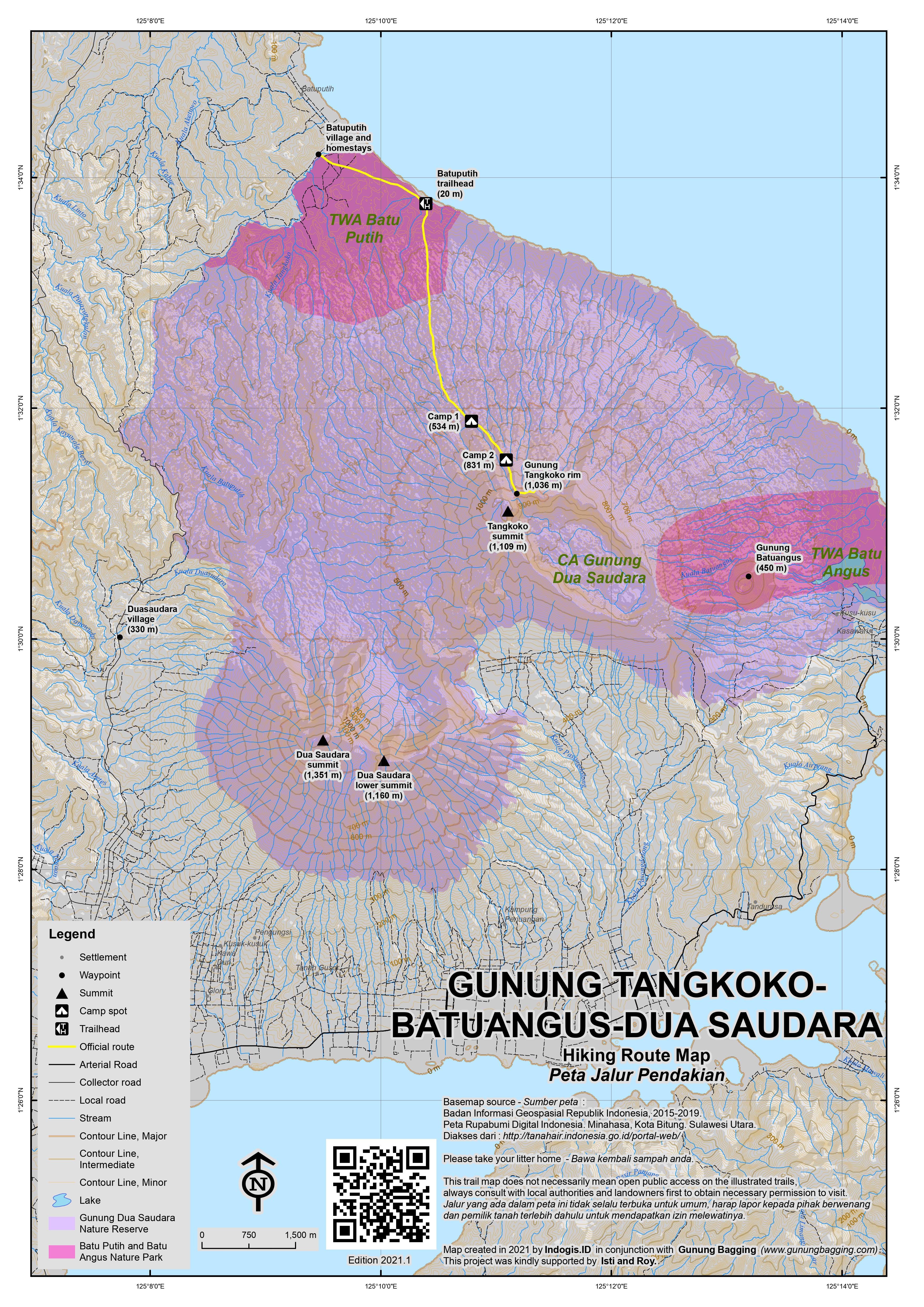
For a high quality PDF version of this and other trail maps, please download from our Trail Maps page.
Practicalities
- Getting there: Plenty of buses between Manado and Bitung. Taxi from Manado to Batuputih costs around Rp250,000.
- Guides and GPS Tracks: Want a PDF version for your phone? Looking for a guide? Need GPS tracks and waypoints? Dua Saudara information pack can be downloaded here.
- Permits: Unknown for Dua Saudara. For Tangkoko you need to take a guide from Batuputih. Costs of guides includes Rp15,000 national park fee. Guide costs are fixed and range from Rp85,000 (very short trip) to Rp400,000 for a hike to the Tangkoko crater rim.
- Water sources: Unknown for Dua Saudara. None on the route to Tangkoko other than that found in occasional bamboo stems.
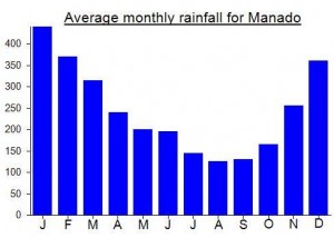
Local Average Monthly Rainfall (mm):
Location
Click on the blue arrow ![]() (top right) to see your current location on the map
(top right) to see your current location on the map
I had hoped to finally hike Duasaudara this year, but it seems that it is still very rarely climbed and so there is effectively no trail whatsoever. My old friend Gary, who I hiked Soputan with many years ago, hiked Duasaudara back in 2010 and you can read his report here: http://hidupkuduniakualamku.blogspot.com/2010/07/gunung-dua-sudara.html
It took them 8 hours and 45 minutes to get to the top from Duasaudara village (west of the mountain) which is over 300 metres above sea level. No views up there, and lots of insects. 1 night camping.
Anyway, in short, it seems it cannot be done as a dayhike, unless you are lucky enough to go up just days after another group, and therefore have some sort of trail to use. If you do a Google search you will find almost no information on hiking to the top (indeed, several local hikers told me it is regarded as a haunted mountain) but several reports of people getting lost up there, either hikers or plantation workers. So, good navigation skills are also essential.
If the higher of the ‘two brothers’ can be hiked from Duasaudara village to the west, it seems the lower of the two peaks (estimated 1,160m) is better approached from the south near the city of Bitung, but once again very few hike it so it needs a lot of time and a lot of care not to get lost…
You can stay in tangkoko or you just make one day tour because you do not enough time is also ok to see wildlif in tangkoko nature reserse .
http://tangkokonaturereserve.blogspot.com
Many thanks to pitcher plant expert Alastair Robinson for identifying the Nepenthes I photographed on this mountain as Nepenthes maxima.
Had a wonderful time in Batuputih. Plenty of foreign tourists to speak to and an American girl studying the calls of the tarsiers in the region.
250,000 seems a little expensive when you first see the rooms at the homestays but when you consider the meals you get it is actually a fair price.
Myself and local guide and expert Iwan headed up to the crater rim after joining the others at the tarsier tree around 5am. Luckily a group of scientists studying bats had cut their way up the usually overgrown trail so we were at the rim in about 3 hours. From that point the trail was pretty hard work and the clouds allowed only an reasonable panorama from the lesser eastern top which is generally the culmination of a climb to the ‘summit’. On the way up we spotted several hornbills above us plus ebony and fig trees.
The heavens opened just as we began the descent and we were utterly filthy and soaked by the time we made it back down to the starting point.
I imagine that this is a really good addition in the dry season for those looking for a bit more of a challenge than the usual trip to see wildlife on the slopes of the mountain. It remains to be found out whether or not any local hikers have summited Dua Saudara but if they have it seems almost impossible that they have done so recently from the Tangkoko side.
Iwan kindly gave me a lift back to Manado airport on his motorbike (just under two hours) and we enjoyed the post-thunderstorm air clarity from the mountain road which leads down to Batuputih.