
Facts
- Elevation: 2,046 m (6,713 ft)
- Prominence: 400 m
- Peak category:
 Spesial
 - Region:
 Sarawak
 - Range: Kelabit Highlands
- Division: Bahagian Limbang
- Coordinates: 3.8713, 115.3869
- Rating:
 (2 votes) Add your rating
 Loading...
 - Other names: Batu Lawih
Photos
")
")
")
")
")
")
")
")
")
")
")
")
")
")
")
")
")
")
")
")
Bagging It!
Batu Lawi, also spelt ‘Lawih’, is one of Borneo’s most iconic mountains, with two steep sandstone summit pinnacles. It can be clearly seen from the small aircraft that fly daily from Miri to Bario. The lower ‘female’ one of the two is about 1,930m whereas the taller ‘male’ peak further north is around 2,046m above sea level. The mountain is of great significance to local people including the Kelabit and the Penan. They successfully campaigned to have it included in the Pulong Tau (‘our forest’) National Park which also covers nearby Gunung Murud, the highest in Sarawak, and much of Gunung Tama Abu (2,113m and a prominence of around 702 metres) a vast fortification-like range stretching down to the south-west of Bario which is one of Sarawak’s least accessible peaks and was only summited first in 2009 from the west side via Long Lellang. This Park was gazetted in 2005 but the foothills of the great mountain have been heavily scarred by logging activities over the years.
The city of Kuching fell during the Japanese occupation in late 1941, and much of coastal Borneo was under Japanese control by early 1942. The self-sufficient Kelabit Highlands were a different story, being so remote and rather far from the coasts. Batu Lawi, being so iconic, was known to the Allies as ‘Mount 200’ and used as a key landmark for aviators flying over the interior (usually from Morotai airbase, in present-day North Maluku, Indonesia via The Philippines). In March 1945, Tom Harrisson parachuted into the “Plains of Bah” around Bario with seven other Westerners, in order to assist the local people and work together to prevent Japanese conquest of the interior. Tragically, the plane that Harrisson travelled on never made it back to the Philippines and no trace was ever found. Harrisson didn’t find this out for several months.
A little later, in 1946, Harrisson along with a team of local Kelabit people – including Lejau Unad Doolinih – finally made it to the top of the female peak where Harrisson left a wooden memorial to Flight 200. After the surrender of Japanese forces, Harrisson became Curator at Kuching’s Sarawak Museum and wrote an excellent book on the Kelabit Highlands entitled ‘World Within’ (first published in 1959) which includes many sentences devoted to the near-mythical ‘great twin white pinnacles’. 40 years later in 1986, a British and Australian team led by Jonny Beardsall reached the top of the male peak. And in 1987, a second memorial made of bronze was erected next to Harrisson’s wooden memorial on the female peak. In 1999, Lightner and Volker climbed the highest peak in an expedition which was written about in Lightner’s 2002 book ‘All Elevations Unknown’. The Swiss campaigner Bruno Manser supposedly planned to climb Batu Lawi in May 2000 – after a failed attempt in 1988 – and was never seen again. The male peak was successfully climbed again in 2007 by Malaysians from a university in Cyberjaya on the outskirts of Kuala Lumpur.
Bario is one of the very finest places in Borneo to spend a few days and has genuinely rich culture and history with hundreds of ancient megaliths dotted around the landscape including the famous Batu Ritung dolmen at Pa’ Lungan. One of the reasons for its great success as a settlement is the salt springs found in several of the villages which has a high natural mineral content. To reach the base of the mountain from Bario takes a couple of days, so a proper trip to view the summit cliffs up-close requires a minimum of 5 days in total. Experts would need several more days for an actual rock climb up to the top of the male peak. The lower female peak is a scramble, especially near the very top where a rope ladder is usually required, but there is only very limited space for erecting tents. John Briggs, author of ‘Mountains of Malaysia’ (published in 1988) was of the opinion that the dawn view here is the second best in all of Malaysia (after Gunung Trusmadi). Batu Lawi is perhaps one of the best examples of a peak which is visually extremely prominent, being a vertical finger of rock, yet because it is connected via a high pass to the higher Gunung Murud it has only 400 metres of topographic prominence.
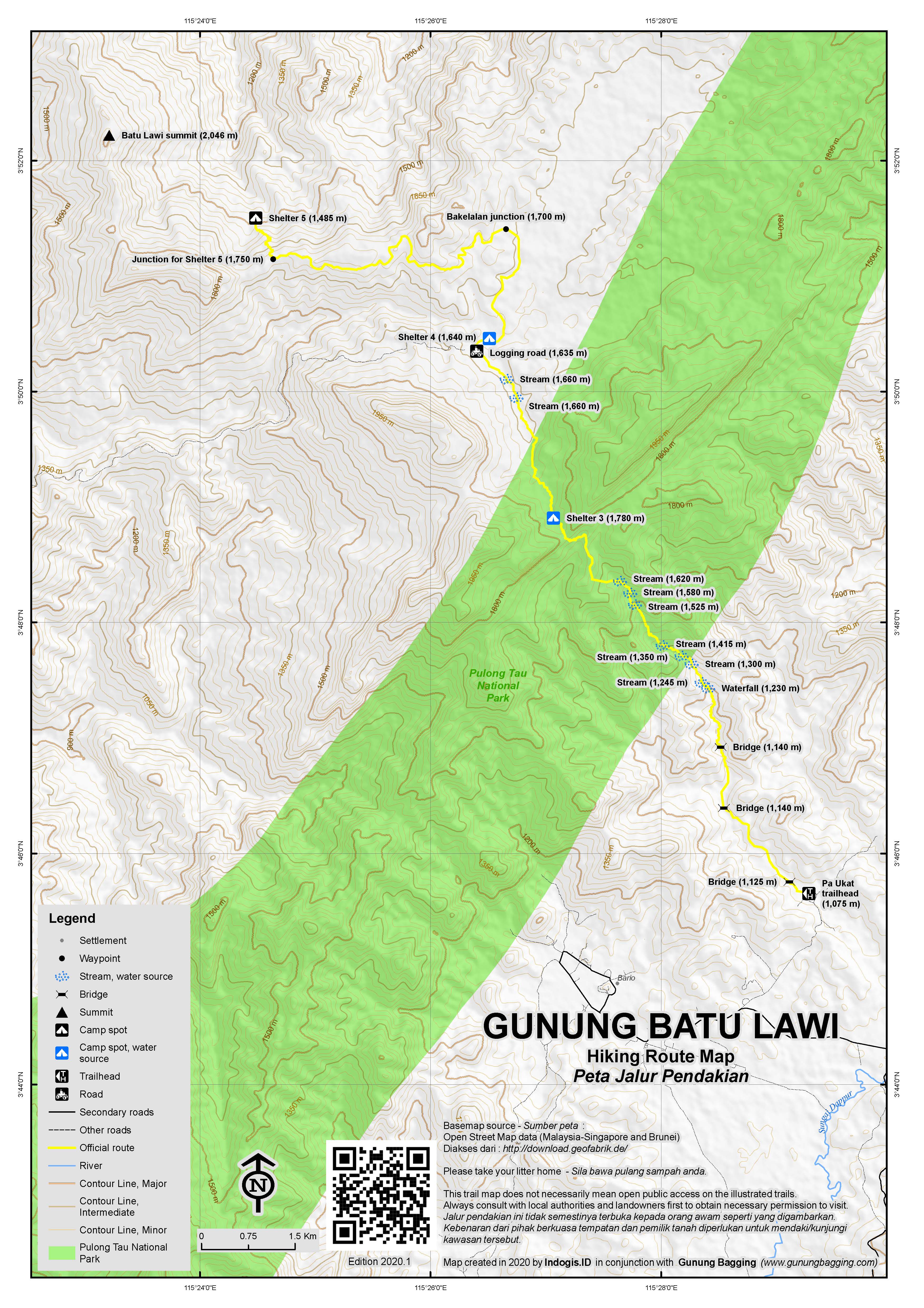
The usual trailhead is in the village of Pa Ukat (1,075m). This leads northwards via many stream crossings and Shelter 3 (1,740m), Shelter 4 (1,575) which is near a logging road and finally Shelter 5 (1,452m) which is at the foot of the peak.
At present, the standard itinerary looks like this:
Day Zero
Arrive in Bario. Visit the Pulong Tau National Park office to register. Purchase any last-minute food items. Have a briefing with your guide prior to starting the hike the next morning. Most mornings, the trekking will begin at 8am.
Day One – 7-9 hours of hiking from Pa Ukat to Shelter Batu Buli (Shelter 3)
Transport from Bario to Pa Ukat, which takes around 20 minutes. The trailhead is unmarked. To begin with, the path follows the edges of rice fields, over a wooden bridge (1,077m) and past an area where a water buffalo often grazes. There’s a warning sign for the animal, so do take care, especially if for some reason you come past here on the final day in the dark! At the edge of the cultivated fields of Pa Ukat is what is known as the last farm (1,091m). This simple wooden house is a good place to have a short rest before entering the forest.
Once in the forest, there are numerous river crossings, so numerous that it becomes challenging to count them. There are also several sections of steep trail, both ups and downs. Depending on how recently another group of hikers has been here the trail could be rather vague in places. Leeches are very common here and difficult to avoid even with leech socks. There is a National Park sign (1,225m) just before a collection of boulders. Not far beyond this is a small pool of water which is apparently a salt lick and therefore very attractive to animals (and local hunters).
Eventually, as the trail leads higher it becomes more clearly-defined. The first excellent viewpoint (1,723m) is of Batu Buli (2,082m), a significant mountain in its own right. Batu Buli is to the left (west) of the trail, with the north or main peak being 2,082m (6830ft – 3.8294, 115.4319 – and with a prominence of approximately 283 metres) and the southern peak being 2,094m (6870ft – 3.8114, 115.4403 – and with a prominence of approximately 360 metres). The mountain is famous for its pitcher plants though these are much higher up the mountain and are not seen on this section of trail to Batu Lawi.
The trail then weaves its way through a gap in the Tama Abu cliffs (1,775m), passing across what on a map is clearly the Batu Buli ridgeline. The terrain changes here, with very mossy and slippery rocks to cross over with holes on either side. A beautiful, stone carving of a human figure on a mossy rock marks the edge of Bario territory, for those few entering or leaving the district this way. This is one of countless stone carvings and megaliths scattered across the Kelabit Highlands, though this one apparently only dates from 1940.
It is not much further to Shelter Batu Buli (Shelter 3, 1,740m), located on the far side of a stream with water that can be used for cooking. Purification tablets are recommended for an added layer of safety for drinking water. There are no views here but it is a pleasant spot in the forest. This, along with 4 other shelters were contructed in 2018 with funds from Volvo Trucks Malaysia. Shelters 1 and 2 are much closer to Bario and on although all 5 shelters are on the 25km Bario Ancestral Trail, only 3, 4 and 5 are on the route to Batu Lawi. The shelters could fit 10 hikers quite easily and are similar in size and design. Reaching all of them is a great feeling as it offers a welcome respite from leeches, mud and poor weather. That tents are not needed on this trek is a major advantage. Water is available at the nearby stream. Guides and porters usually sleep in hammocks below the main room of the shelter.
Day Two – 7-10 hours of hiking from Shelter Batu Buli (Shelter 3) to Shelter Batu Lawih (Shelter 5) passing via Shelter 4
Day Two begins with a slight descent through mossy forest, negotiating more mossy rocks and crossing on mossy logs over small streams of red-brown water. The trail then widens and vegetation becomes less dense. This is a sign you are on an offshoot (1,638m) of the main logging road, no longer used, which is the main feature of the day’s hike. There are wide pools of boggy water resembling small swamps and an increasing number of stunning pitcher plants in the cleared areas. The logging may have been dreadful for some species, but others appear to have thrived in the changed conditions. After a significant river crossing (1,615m), the main logging road (1,611m) is soon reached, and is much more overgrown than might be expected. However, the sunlight is piercing and those with pale skin ought to wear sunscreen for the rest of the day. On the way back it is easy to miss this turning off the old logging road without the help of your guide or a well-placed marker (or GPS waypoint).
Follow the grassy old track down a little way to reach Arur Bila’ Bigan Shelter (Shelter 4, 1,575m). Most hikers should have reached this point in under 3 hours from Shelter 3. It makes a perfect spot for lunch and is also known as Ulu Limbang, being the source of the large Limbang river. Note that guides like this shelter best of all as there are two separate buildings – the main Shelter 4 and an older, more ramshackle building where the guides tend to stay. It also has less chance of being damaged by a fallen tree than the other shelters as it is in an open area with few towering trees near it. Once again, there is a nearby stream for collecting water for cooking and filling up water bottles.
Just a few metres beyond Shelter 4 is the biggest river crossing of the entire hike and could be dangerous if the water level is high. If it starts raining then you ought to cross while you can still do so safely, rather than waiting too long and being stuck at Shelter 4. After the river crossing, the next few hours are somewhat monotonous, weaving around the highland terrain in a rather inefficient manner but following the old, overgrown logging road. Just as the pitcher plants have done well in these more open landscapes, some animals such as deer, sun bears and snakes seem to be thriving here and you may be lucky to spot some. Otherwise, the trek is punctuated with the remains of an old wooden sign at the junction (1,655m) for Bakelalan and Gunung Murud, on trails almost never used now, and then discarded metal fuel drums (1,718m) once used by the loggers and now used by the very occasional hiker to sit on.
Again, there are some turnings which could easily be imperceptible without the guide’s knowledge or stored GPS waypoints so it is advisable to be very aware at any junctions, however minor they seem. At one or two points on the wide, grassy logging track you may catch a glimpse of the twin peaks of Batu Lawi but, as ever, it depends on the weather.
The final hour of the day is perhaps the most mentally-draining as it is down steeply through forest (from 1,693m). All of these metres lost in descent will of course need to be regained the next day on the hike up to the saddle between the male and female peaks. However, Shelter Batu Lawih (Shelter 5, 1,452m) is a brilliant spot, and in clear weather you can see Batu Lawi from upstairs. Water is slightly more difficult here compared to Shelters 3 and 4, with a stream around 10 minutes away, prior to the shelter, and involving a small descent. This is a fairly long day, and will have taken most hikers anything from 7 to 10 hours to complete. If you are lucky you will have a nice evening here, with some great photo opportunities of Batu Lawi.
Day Three – 6-8 hours of hiking from Shelter Batu Lawih (Shelter 5) to Batu Lawi saddle and back again
From Shelter 5, the trail leads even further down, despite this being summit day, to two small river crossings (at 1,304m and 1,355m) at a place known as Pa Tabun. There are some remnants of logging tracks even here, noticable when the trail seems wider, flatter, or with less dense vegetation. The trail then leads steeply up through the increasingly mossy forest and eventually you will see the gleaming bare white rock of Batu Lawi faintly visible through the trees. As you skirt round the cliffs (1,806m) of the male peak, there are some sections of trail with rope to help you negotiate very steep terrain, go past a small cave which would be a useful shelter in poor weather, and eventually get onto the saddle between the male and female peaks at an elevation of around 1,830m.
There are expansive views on either side of the saddle. For almost all hikers, the thought of attempting to scale the male peak is an unrealistic one, and even for those who have the necessary technical skills it would require several extra days. The alternative destination is the female peak, which at approximately 1,930m is only around 100 metres higher than the saddle, but even that is incredibly challenging, especially as a few tricky sections have ropes which are not sufficiently maintained to be safe or simple. Whether you attempt the female peak or not, the views here in this truly special and remote place are simply stunning.
Those who reach the female peak will pass by the bronze memorial placed on Batu Lawi in 1987 by an Australian military team to replace Tom Harrisson’s wooden memorial of 1946. The bronze memorial replicates what was legible from the original:
“….of 200 Flight….
They successfully dropped us at Bareo 25/3/45 but they never got back to Moratai. By Batu Lawi we steered on this and four previous attempts. The RAAF called in Mount 200. I pledged my word to climb it for them in their memory. Here in lonliness I remember my friends.
… Nagalewan Rajah
M…RI”
The trail back down to Shelter 5 is the same as the route up.
Day Four – 5-6 hours of hiking from Shelter Batu Lawih (Shelter 5) to Arur Bila’ Bigan Shelter (Shelter 4)
Although it is possible to hike back from Shelter 5 to Shelter 3 on Day Four, most hikers will be exhausted by this stage and opt for an easier day of 5-6 hours rather than 7-9. Even if you did reach Shelter 3 on Day Four, you would still have a considerable hike back to Pa Ukat on Day Five. Remember the wide river crossing to be negotiated just prior to Shelter 4. It is crucial to be over this while it is safe, so a late start from Shelter 5 is not wise as afternoon rains could make the crossing more difficult.
Day Five – 8-10 hours of hiking from Arur Bila’ Bigan Shelter (Shelter 4) back down to Pa Ukat
The final day is quite an energy-sapping one. Gruelling, even. Starting much later than 8am is not recommended as it is a good idea to be back in Bario before nightfall. Once down at the last farm, your guide will hopefully contact a driver. All being well, you will be met in Pa Ukat by the driver to take you back to the centre of Bario for a much-needed shower and celebratory meal.
Day Six
Fly back to Miri from Bario, and onward to Kuala Lumpur or wherever you are headed. The first flight from Bario is usually at 10 or 11am so if you have remaining energy then you do have time for a very quick sunrise ascent of Prayer Mountain on the edge of Bario before leaving.
Bagging information by Dan Quinn (August 2024)
Trail Map
For a high quality PDF version of this and other trail maps, please download from our Trail Maps page.
Practicalities
- Getting there: For Malaysian domestic flights and flights within Southeast Asia, for example to Kota Kinabalu or Kuching, we recommend Baolau. Fly to Bario with MASWings from Miri.
- Guides and GPS Tracks: Want a PDF version for your phone? Looking for a guide? Need GPS tracks and waypoints? Batu Lawi information pack can be downloaded here.
- Trip planning assistance: Would you like Gunung Bagging to personally help you in arranging your whole trip? Please contact us here.
- Permits: Register with locals and take a local guide from Bario, booked at last a week in advance. Typically RM1350 per person for a minimum of 2 hikers, with slighly lower prices for larger groups. Porters and food preparation available for an additional fee. RM20 Pulong Tau National Park entry fee for non-Malaysians and less for Malaysians, but this fee is usually included in the full price quoted.
- Water sources: Lots of streams but it is essential to communicate with your guide about the final water source on each day of the trek.
- We recommend Safety Wing as travel insurance for overseas travellers and tourists hiking up to elevations not exceeding 4500 metres.
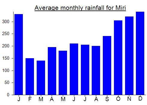
Local Average Monthly Rainfall (mm):
Location
Click on the blue arrow ![]() (top right) to see your current location on the map
(top right) to see your current location on the map
Doing this 5-day hike from Bario was one of the most memorable trips I have ever done. After finishing the Gunung Api Pinnacles trek at Mulu Park I spent a night in Miri before flying in to Bario. The weather was great, with nice views of Prayer Mountain on our approach. It’s probably always worth flying to Bario in the morning if you can so that you have a better chance of views.
6 of us were booked to do the trek, and it was with some sadness that I heard one of our team had missed his flight in KL and would not make it in time. The rest of the group arrived as planned and we visited the Pulong Tau office, where I was pleased to see they were using the Gunung Bagging map on their wall, though this will need an update now.
Bario is a little changed since last time I visited. Two key things, both of which are positive. Firstly, there is a reasonable data signal for phones around Bario now, so messaging on WhatsApp is straightforward. Secondly, there has been a relaxation of the rules about alcohol, so you can find the Sagota beer from Vietnam is several shops. Back at the longhouse I started reading Bruce Chatwin’s Songlines as it was on the shelf there asking to be read. The first evening we enjoyed both the local rice and local pineapple, both of which are to my tastebuds the best in Malaysia if not the whole of Asia.
Day 1 was a bit tougher than expected as there have been few trips to Batu Lawi in recent years so the trail is vague in places and would be impossible without a guide. We made it to Shelter 3 in 7hr30min. Lots of river crossings and slow going over slippery terrain. All of these shelters have the main room upstairs and it is locked, so you need your guide to bring the key with him. In an emergency, the area below the main room will certainly keep you dry and this is where the guides and porters sleep, usually on hammocks.
Almost every day has an 8am trekking start time as standard, assuming it is not raining, and this is presumably to have enough daylight to eat breakfast and pack the backpacks. Day 2 is a long one and through some pretty remote terrain. No wonder Bruno Manser disappeared here, though there are those who suggest he may have been bumped off. This is certainly not hospitable terrain and even the Penan apparently do not hang around near Batu Lawi, especially since the logging operations took out much of the precious wood that they may have been able to sell themselves in much smaller quantities. The National Park, first founded in 1998, has more recently been extended to include Batu Lawi which is great news. The less than great news is that logging tracks do somewhat scar parts of the landscape here, and it ought to have been protected before that was allowed to happen rather than after. However, Mother Nature is quickly taking back control of the tracks and in some places some species seem to be doing well in these disturbed areas.
It was a delight to get down to Shelter 5 as by the time we got there it was pouring with rain. The difference between having to pitch a tent in the leech-ridden jungle and simply walking up some wooden steps and unrolling your sleeping mat is immense. It’s common across Malaysian Borneo, though the other key hike near Bario – Gunung Apad Runan – has only one shelter, and it is apparently now partially damaged, with a tree fallen through the roof. Perhaps Volvo Malaysia can consider funding the construction of a few more shelters for Apad Runan.
As it is, there is a small risk that if nobody has hiked Batu Lawi in recent months then when you reach a shelter, it may be damaged by a fallen tree. Or become home to a large number of bats. Lots of things can happen in just a few short weeks in the forest, and if the shelters are not frequently used they can fall into disrepair. Maintenance and responsible use is essential.
As the rain cleared at Shelter 5, suddenly the mythical twin peaks appeared through the mist, like ghosts at first, slowly becoming more well-defined. It had been worth the slog to get here. Don’t point, said our friendly guide, as Batu Lawi is shy!
Despite being a shorter day, Day 3 up to the saddle was a more exhausting affair for me. I had a cough and headache that would not shift. Another memorable moment came when the white cliffs of the peak were first seen through the trees when approaching the saddle. There are the remains of a porcupine up there near the cave just before the saddle.
The 4 Singaporeans, all agile folk, made it up to the Female Peak, around 1930m, higher than many sources suggest. This is only 100 metres above the saddle, but it is a challenging 100 metres of elevation and I reached one awkward boulder at an elevation of around 1,860m that I just could not manoeuvre around. I tried several times and just could not get around it. Too much belly fat, too clumsy and not enough agility. This being one of the most remote places I would visit on my 6 week trip, and also near the start of the trip, I decided to taking a risk here would be a very idiotic idea, so I remained content to enjoy the views on both side of the saddle.
When the Singaporeans got back down I was informed that the rope ladder at the very top was not in good condition at all and could do with replacing urgently. Again, these trails need to be used regularly for the maintenance to be possible. Let’s hope it is made safer in the near future so that others can get to the top of the female peak. I missed out on seeing the memorial but one of the group kindly sent me his photos of it, one of which is published in the gallery. They saw no trace of the original wooden memorial left by Tom Harrisson. Author of ‘Mountains of Malaysia’ John Briggs and locals camped up here in the 1980s and claimed it was the second-best viewpoint in Malaysia (from memory, after Gunung Trusmadi with its early morning view to Kinabalu).
From Shelter 5 to the saddle was 4 hours, and back down in 2.5. Exhausting though.
Day 4 is a short day, and it took us 4hr40 back to Shelter 4. It was quite hot, despite the elevation, so I put on a fair bit of suncream. The river just before the shelter was higher than on the outward trek and it was with considerable relief that we all got across safely. Make sure you keep your valuables at the top part of your backpack to avoid it getting soaked should the bottom of your bag catch the water’s surface. My headache still hadn’t gone, and had actually moved into position above my right eye. Paracetamols didn’t help and neither did the smoke from the cooking going on below!
Day 4 is a relaxed day, relatively speaking, prior to the long Day 5 getting back to Pa Ukat. It was very gruelling and muddy, with more ups and downs than I remembered and it was wonderful to be back at the last farm where the edge of the forest meets the edge of cultivated farmland on the outskirts of Pa Ukat. One of our team memorably described the trek as ‘manageable’ which probably understates how intense it was at times! A nice woman picked us up and took us back to the longhouse for a much needed wash. Considerable blood was spilt thanks to the leeches.
I planned to hike Prayer Mountain the next morning prior to leaving Bario but none of the others wanted to join me. Probably sensible of them. As it turned out the weather was cloudy and I ended up on the wrong trail right from the start anyway. So next time I will do it, hopefully using the right trail and along with the multi-day hike to Apad Runan, and a visit to Pa Lungan to see the Batu Ritong megalith. Getting to Pa Lungan by vehicle is very expensive… RM600 return, so if you cannot find several people keen on doing it, you need to walk. Cycling is no good because of areas of track that are thick mud. It’s about 8 hours return on foot, so certainly possible in a single day from the centre of Bario.
Many thanks to Julian, an excellent guide.
There was a film crew with Lughtner and Volker, see All Elevations Unknown. Was the documentary ever made? Where can I find it? Best wishes liandamartin@gmail.com
A 5-day Gunung Bagging hike to Batu Lawi will be happening in early July 2024. This doesn’t happen often! Places very limited. Please leave a comment and I will send futher details. Dan
Pm details pls. Batu Lawi hike. TQ
What about when it was climbed by Sam lightner in 2000 and also the Indonesia team that climbed it