
Facts
- Elevation: 825 m (2,706 ft)
- Prominence: 153 m
- Peak category:
 Spesial
 - Region:
 Peninsular Malaysia
 - Malaysian state: Negeri Sembilan
- Range: Banjaran Titiwangsa / Main Range
- Coordinates: 2.6987, 102.0480
- Rating:

 (2 votes) Add your rating
 Loading...
Photos
")
")
")
")
")
")
")
")
")
")
")
")
")
")
")
")
")
")
")
")
")
")
")
")
")
")
")
")
")
")
")
")
")
Bagging It!
Mount Angsi is one of the most popular hill treks in Malaysia. It makes a good introduction to hiking for beginners and can be accomplished in half a day. Most hikers can be at the top in under 3 hours and back down in less than 2 hours.
There are two trailheads around 3 kilometres from each other. By far the most popular route starts at Bukit Putus to the north of the peak where you can buy a ticket and park your car. There is even a toilet block and a map of the route. The other trail starts a little further east at Ulu Bendul and meets the main route at the summit. A circuit is the best way of enjoying the mountain to its maximum but be aware that the Ulu Bendul route is slightly longer, slightly more challenging, may be a little more overgrown and that unless you park a second vehicle there you will have a rather boring walk along the road between the two starting points either at the beginning or the end. The Ulu Bendul trail requires a little more time. The Bukit Putus trailhead is slightly higher at over 250 metres above sea level compared to around 160 metres at Ulu Bendul so consider this before deciding where to start and finish.
From the grand trailhead, the Bukit Putus path leads up some steep cements steps and then metal steps, past a further large ‘Gunung Angsi’ sign and finally into pleasant forest with a clear, wide and obvious trail. This mountain gets incredibly popular at weekends, so if you enjoy solitude do try to hike on a weekday! A guide is not strictly required unless you are inexperienced.
There are one or two rest areas en-route including near a water source, and also some moderately good views to the right of the trail at its flattest point. One is called ‘reservoir view’ an offers a view to Sungai Terip reservoir though unless you start very early the view is likely to be a little hazy. There is also an amusing ’18 minutes to the summit’ sign which is not far-off in its estimation!
The summit features a pleasant roofed shelter, various signs and an attractive – though partially collapsed – mental beirut which is where the highest point of the mountain appears to be. There is also a small stone marker hiding under the beirut. There are partial views in several directions.
Peak-baggers should note that the highest part of this range is actually the obscure Bukit Simpang Empat (Crossroads Hill, or literally Four-way Junction Hill) at 936 metres but there are no reports of anyone having hiked here so there is not likely to be a trail. It lies around 5 kilometres east of Gunung Angsi and can be seen from the summit. The Ulu Bendul trail is unmarked but can be discovered fairly easily just a few metres to the left of the beirut. This narrow trail leads steeply down into the valley before winding its way back via Kem Tangga Batu (stone stairs) to the main road around 3 kilometres further east of Bukit Putus.
Most hikers will not be aware that Gunung Angsi was the site of a minor hill station in the colonial era, with a bungalow probably not unlike that which existed on Bukit Kutu, where entrance steps and a chimney can still be seen. This is because the location is not at the highest point of Gunung Angsi. There are actually three tops. The northern top is the true summit which people visit today. There is a middle top, presumably dense forest and no views. And there is a southern top (776m) which is location of the Gunung Angsi bungalow. It’s around 1.3 kilometres south of the true peak and there is probably nothing resembling a trail there at present.
According to old maps, there were two routes up to this bungalow, from the north near Bukit Putus, following a fairly similar route to the hiking route today, and from the south-west via rubber plantations to the east of Sungai Gadut. Photographs taken by botanist E.J.H Corner in 1930 show a hilltop bungalow in the distance with a tall chimney, a tennis court, and some pleasant views of nearby forest from the bungalow. One informal report suggests that there are foundation walls still to be found in the forest today, much like those on Bukit Arang Para in Perak. At present, however, there is no trail and access is not permitted by the forestry department yet. It is hoped that this site will be re-opened to responsible and respectful hikers in the near future.
Bagging information by Dan Quinn (June 2022, updated September 2024)
Trail Map

For a high quality PDF version of this and other trail maps, please download from our Trail Maps page.
Practicalities
- Getting there: For Malaysian domestic flights and flights within Southeast Asia, for example to Kuala Lumpur, we recommend Baolau. Just over an hour’s drive from KL. The closest train stations are Seremban and Senawang but public transport onward from there may not be simple to arrange.
- Guides and GPS Tracks: Want a PDF version for your phone? Looking for a guide? Need GPS tracks and waypoints? Gunung Angsi information pack can be downloaded here.
- Permits: RM5 per person purchased at the Bukit Putus trailhead. The office opens at 8am Monday-Friday and 6am on weekends but note you are not allowed to start hiking after 11am.
- Water sources: Available around halfway up on the Bukit Putus route but it makes more sense to bring water on what is a short hike.
- We recommend Safety Wing as travel insurance for overseas travellers and tourists hiking up to elevations not exceeding 4500 metres.
Local Average Monthly Rainfall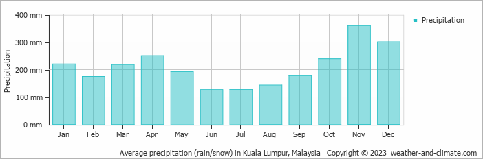
Location
Click on the blue arrow ![]() (top right) to see your current location on the map
(top right) to see your current location on the map
Still no info on the mysterious Bukit Simpang Empat – the highest peak of this large range. Other peaks in the range that are higher than Angsi, and occasionally hiked, include Gunung Pasir (892m) and Bukit Ulu Pilah (911m).
Also interesting to note that the Angsi hill station bungalow is marked on an FMS map as being on the southern, lower top of Gunung Angsi. Actually there are three tops. The most northerly is the summit which is well frequented and the southernmost (approx. 776m) is apparently the location of the bungalow, about 1.3km from the true summit, probably with no path. I wonder if anything remains of it now – there is very little information available online so perhaps no hikers have been there in recent decades. Do get in touch if you have.
Finally got round to doing Gunung Angsi last month. A very pleasant trail and only one other group as it was midweek. We thought about doing the Ulu Bendul descent but it looked a little overgrown and I had had no sleep the previous night so we decided to head back down the same way.
As usual, thumbs up to Negeri Sembilan authorities for making ticket purchase so easy and affordable. Why can’t the other states do the same and save so much administrative hassle for everyone?
A very worthwhile trek in its own right or in preparation for something bigger.