
Facts
- Elevation: 1,810 m (5,938 ft)
- Prominence: 1,610 m
- Ribu category:
 Kurang Tinggi
 - Province:
 Nanggroe Aceh Darussalam
 - Coordinates: 5.4471, 95.6559
- Rating:

 (5 votes) Add your rating
 Loading...
 - Other names: Solawa Agam, Solawaik Agam, Selawadjanten, Goldberg
- Eruptions: 1839
- World Ribus ID: 69069
Photos


Bagging It!
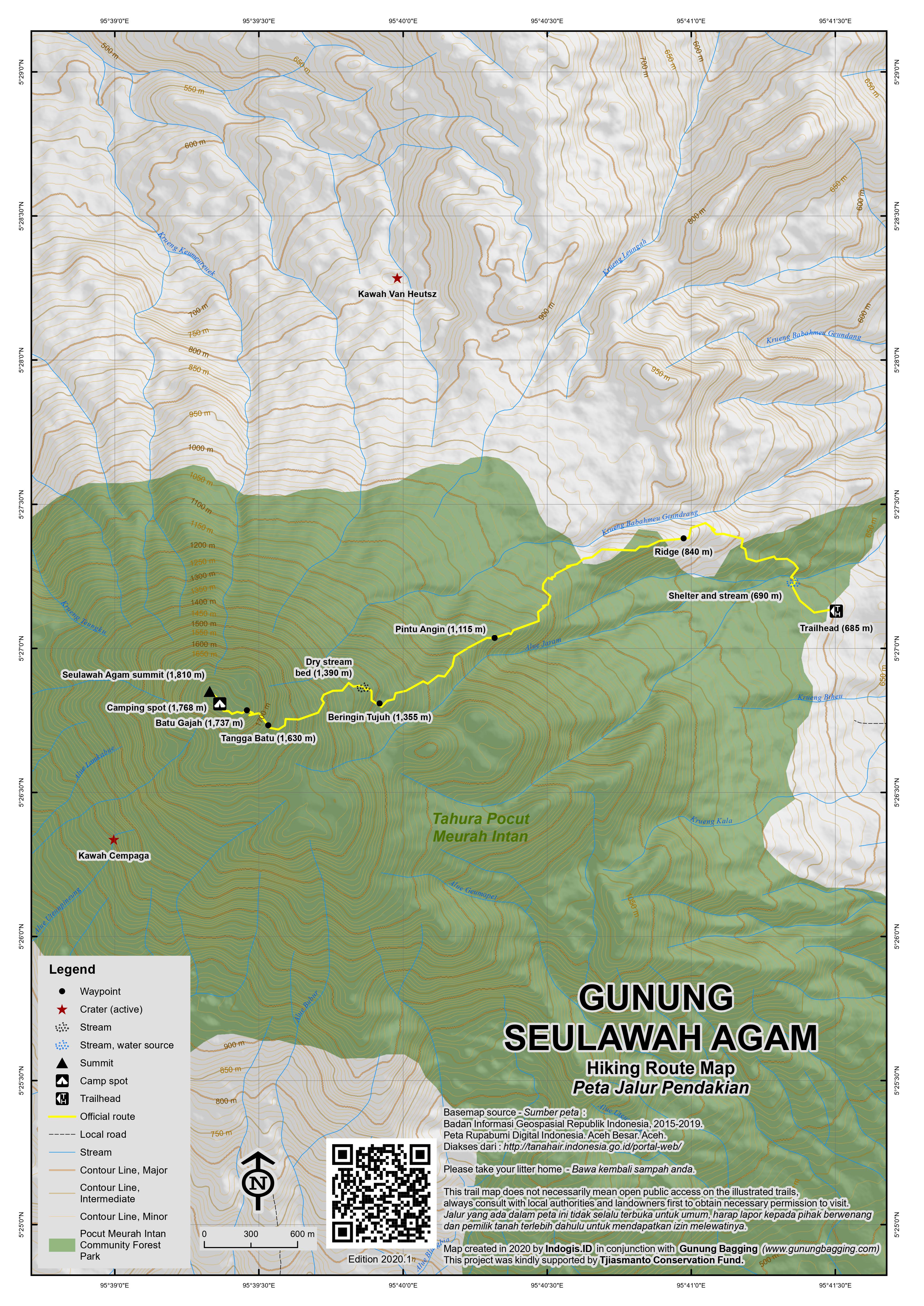
This forested peak is the most noticeable mountain near Banda Aceh. It has a large caldera on the southern slopes, known as Lam Teuba, but it has not erupted since 1839. The traditional hiking route starts east of the peak, 2.5km north-west of Saree (pronounced ‘Saray’), up the lanes behind the mosque. Saree is about one and a half hour’s drive (70km) from Banda Aceh. The hike can be done in one long day although there are several places suitable for camping. The lower slopes of the mountain are full of monkeys and squirrels and apparently the forest is home to lots of white and purple orchids, usually spotted in December. Be prepared to meet leeches during the rainy season but conversely you may not see a single one during the dry season.
There is space for parking one car beside a smaller mosque (630m) just 5 minutes from the unmarked trailhead which is basically a track through farm fields. The crucial thing to find is the correct entrance to the forest. This is a small cement marker with ‘THR70’ written on it (685m). From here it is just 5 minutes to a wooden hut (690m) next to a hiking sign and a small stream which has been diverted from the main stream just a minute further on. The trail continues behind the hut and is fairly clear, assuming no huge trees have fallen over and are obscuring the path. Before long you will find yourself on what feels like a ridge (840m) with a well-defined path. Unfortunately this doesn’t last – fallen trees have made it quite hard to find the correct trail at this point and a guide who has climbed the mountain recently is essential for this very reason. There are bits of plastic taped to tree branches every so often but the next main ‘landmark’ is ‘pintu angin’ (wind door or even ‘porthole’) at 1,115m above sea level. This spot is on the edge of a steep drop with some reasonable views up to the higher slopes of the mountain. You should have reached this point after approximately 2 hours.
The next signposted point of interest on the trail is a cluster of old banyan trees known as ‘Beringin Tujuh’ (seven banyans, 1,355m). After this, the trail once again becomes a little unclear, but you need to drop down very briefly just 10 metres or so into a dry stream bed (1,390m) before immediately ascending out of it. Beyond this, the trail gets steeper as you begin to climb over a rockier area known as ‘tangga batu’ (stone stairs, 1,630m). At the end of this is a large boulder with a trees trunk curving over it (1,737m). This is known as ‘batu gajah’ (elephant rock) and it genuinely does bear a striking resemblance to an elephant. You may even be able to clamber up onto it for photographs.
Soon a camping spot is reached (1,768m). It is not far from here to the true summit which is marked with a small memorial to a handful of the 2004 tsunami victims plus an old Dutch triangulation pillar which was refurbished in 1995 by a local nature lovers’ club. The Bakosurtanal topographic map lists the height as 1,809.8m.
There’s also a treehouse (take care on the steps) but even from up here views are very limited though you should get a glimpse of the coast in the distance. Fast hikers should be able to reach the top in about 4-5 hours total, although it could take 6 hours if you’ve carried a huge bag and tent up with you. Beyond the markers is another fairly large and flat spot big enough to accommodate several tents. It seems that local hikers used to climb this mountain regularly but they have recently become bored with it, and the lack of litter on the trail certainly leads you to assume that it isn’t climbed as often as you might expect for what is a rather accessible mountain.
The temperature at the summit is wonderful (assuming no rain or strong winds) and you should be able to hear the call of siamangs in the distance. Back down the same way (the only route on this mountain, apparently) should take just over 3 hours. When back at the trailhead you will notice a much smaller peak on the other side of Saree. This is Seulawah Inong – the female mountain counterpart to the male Seulawah Agam.
To visit the rarely-visited active crater areas requires entirely different hikes – one from the southern side to Kawah Cempaga (1,200m), and one from the north-east to Kawah Van Heutsz (780m) which was apparently the site of the 1839 eruption.
Bagging information by Dan Quinn (October 2013)
Trail Map
For a high quality PDF version of this and other trail maps, please download from our Trail Maps page.
Practicalities
- Getting there: It takes just under 2 hours to reach the trailhead from Banda Aceh. A taxi from the airport to the city is Rp85,000 (Sept 2013).
- Guides and GPS Tracks: Want a PDF version for your phone? Looking for a guide? Need GPS tracks and waypoints? Seulawah Agam information pack can be downloaded here.
- Trip planning assistance: Would you like Gunung Bagging to personally help you in arranging your whole trip? Please contact us here.
- Permits: Not usually required but check with local people about volcanic activity before climbing.
- Water sources: Available at the shelter (690m) near the edge of the forest.
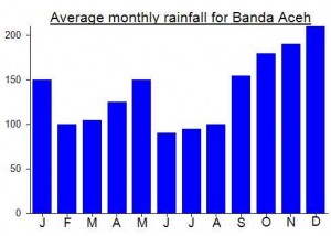
Local Average Monthly Rainfall (mm):
Location
Click on the blue arrow ![]() (top right) to see your current location on the map
(top right) to see your current location on the map
Origins and Meaning
In Malay ‘lawah’ means ‘old’. ‘Seulawah’ could mean ‘old one’. Seulawah Agam could mean ‘old man’ and Seulawah Inong (a nearby lower mountain) could mean ‘old woman’ (Mark Durie, 2011).
Hi Dan,
There are actually a number of tour operators in Banda Aceh who offer treks to Gunung Seulawah. I guess you choose the more expensive one. Perhaps a nect time, consider acehexplorer adventure tours. Would not have cost Rp. 1000.000,==.
Posted by mendel pols | May 8, 2014, 14:15
Hi Dan,
There are actually a number of tour operators in Banda Aceh who offer treks to Gunung Seulawah. I guess you choose the more expensive one. Perhaps a nect time, consider acehexplorer adventure tours. Would not have cost Rp. 1000.000,==.
Delighted to have finally reached the top of Seulawah Agam. It was not easy finding a guide – took many, many calls and messages and many ridiculous prices being suggested such as 2 million, 1.7 million and so on (for a day hike!) Two reasons for this perhaps….. number one – I wanted to climb on a Friday and that is the special Muslim day of the week and also the day when people gather outside the main mosque in Banda Aceh to watch people getting flogged with rattan for various ‘misdemeanours’. Bizarre (alas I missed this particular tourism object). Secondly the number of NGOs previously operating in town was very high indeed, pushing prices up and unfortunately encouraging the over-charging of foreigners.
Supposed co-hiker Kim was not so lucky. After arriving, she had real difficultly finding the hotel with the airport taxi driver and we were on the phone for over 90 minutes, even with me out on the street trying to look for them. Eventually we discovered that she was on Jl Yani in Medan, not Banda Aceh, the plane having made an unannounced and unscheduled stop. Only several hundred km out but the correct street! Oh dear!
I finally found Aceh Adventure and bargained them down to a still very expensive 1 million for the day. They showed up on time, spoke reasonable English and seemed pretty professional. However it seemed to be the first time that they had climbed the mountain! Myself and the proper guide they had found (Bolang – 0852 60291942) were shooting ahead on the trail leaving the chaps with ‘Aceh Adventure’ t-shirts trailing behind. Lovely trail though, apart from the parts where it seems to vanish.
We reached the top and the Aceh Adventure boys decided to get as many photos and even video footage of me as possible for the promotional material. A little irritating, but never mind. Later on, having climbed down they presented me with a certificate (totally unnecessary!) and requested a testimonial there and then before I’d even had chance to take my boots off! Maybe they have a bit to learn about what is appropriate. After all that I had a lovely meal at La Piazza (check the new address on Jl Iskandar Muda), owned by Freddie of Freddie’s resort on Pulau Weh.
And indeed the following day it was over to Pulau Weh.
Alas, I was supposed to climb this mountain last weekend but was so exhausted from 4 weeks of travelling and from the day’s flight from Jakarta (which was annoyingly diverted via Medan) that I just found a hotel and collapsed. Talk of ‘mad dogs on the mountain’ by my taxi driver, increased volcanic tremors and the prospect of a night climb didn’t help either. The next morning I just headed out to Pulau Weh and did absolutely nothing but had a wonderful time at Freddies – perhaps the best beach resort in Indonesia. Must go back there!
After being closed in May 2010, this mountain is definitely open again for hiking. There is a possibility of a regular weekend trip from Jakarta (flying to Banda Aceh) later this year if anyone else is interested….
As if the militant activity is not enough to put people off climbing this one, the government has now issued an alert for a possible eruption following a series of earthquakes….
http://www.thejakartapost.com/news/2010/09/02/govt-raises-alert-level-mt-seulawah-agam.html