Facts
- Elevation: 2,215 m (7,267 ft)
- Prominence: 1,031 m
- Ribu category: Tinggi Sedang
- Province: Sumatera Utara (North Sumatra)
- Google Earth: kml
- Rating:


 (7 votes) Add your rating
 Loading...
 - Other names: Bukit Manja
Photos


Bagging It!
Pangulubao is one of North Sumatra’s most accessible mountains and makes an excellent day hike. The trail makes its way through verdant broadleaf, pine, and sphagnum moss-covered forest, which is in excellent condition. The area is famous for its endemic climbing pitcher plants (Nepenthes spp.) and also numerous species of orchids. During the hike you’ll hear black gibbons calling and crashing around in the trees, and if you hike to the less visited trig pillar area you have a very good chance of seeing them.
The starting point for the Pangulubao hike is approximately 16 kilometres or 30 minutes drive south from Parapat, which is a bustling transport hub on the shore of the majestic Lake Toba. Parapat itself is approximately 4.5 hours drive on good roads from Medan, the provincial capital (via Tebing Tinggi and Pematangsiantar) or 1.5 hours from Silangit Airport south of Lake Toba. Parapat is the gateway for tourists take ferries across Lake Toba to Tuk Tuk, the resort town on Samosir Island.
The starting point is very accessible and well known locally, since the lower slopes of the Pangulubao mountain are the area for an award winning conservation project called “Taman Eden 100”. Locally the Pangulubao mountain and hills surrounding it are called “Bukit Manja” – you might need to use the local name to organize your trip.
It is recommended to book a Taman Eden guide/porter, which will be one of the local staff from the garden. If you are not proficient in Bahasa Indonesia, you might prefer to arrange this in Parapat using one of the handful of travel agents / money changer offices. These are found on the street just next to the ferry/boat terminal for boats across Lake Toba to Tuk Tuk. They can arrange the angkot charter, book the Taman Eden guide/porter, and arrange for a boxed lunch for the hike. Make sure that you explain that you want to get to the Pangulubao stone pillar, not only to the popular viewpoint halfway. Very few people actually go to the trig pillar, and it’s better to have a guide because while the trail is fairly obvious, it is quite challenging in a few place as you clamber over and under fallen trees and even through the boles of some huge old trees. It’s a fun hike through “real” forest, but the trail does require you to get down on your hands and knees many times.
The starting point at Taman Eden is already at 1,245 m, and the trig pillar is at 2,151m so it is only 900 m elevation gain. The trail makes a very easy and gentle start and is extremely good because it is managed by the garden. There are number of other attractions in the garden, such as a small orchid garden and waterfalls, but you simply follow your guide or the signs for Bukit Manja. After approximately 1.5 hours, the trail becomes much steeper as you climb out of an area of predominantly pine forest. After 2 to 2.5 hours you should reach the Bukit Manja viewpoint and camping area, which is at 1,760 metres and just beyond the steepest section of the trail which is best negotiated by using the small ropes for a short section. From Bukit Majna you can see the extensive forest on the slopes of the mountain, and also down to the valley containing the road and the huge expanse of Lake Toba. This is where most people end their hike and return to the carpark or go to the waterfalls. Keen gunung baggers and modestly fit people should be eager to press on into the increasingly dense and mossy jungle. The trail is clear all the way to the trig pillar, but sometimes disappears until you realize you have to crawl through, under or over an old tree or some deadfall. Look out for orchids, pitcher plants and black gibbons. Another 2 hours should be enough to reach the pillar, which was constructed by the Dutch in colonial times.
The pillar is about as far as any hikers go – even reaching this point is pretty rare! However, the true highest point of the mountain is still nearly 2 kilometers away in dense, truly wild forest. We haven’t heard of anyone having been to the highest point and it would probably require an expedition to do so. The Bakosurtanal map suggests the true peak is as high as 2,215m – but this might be an overestimate.
Hikers shouldn’t mind too much that the true peak is difficult to reach, for although the Ribu cannot be bagged in a single day the climb to the pillar and back is a splendid day hike. The return route to Taman Eden is much quicker – even including time to take a well earned rest at the viewpoint at Bukit Manja, you should easily be back from the pillar in 3 hours.
To return to Parapat, and probably back to Tuk Tuk for some well-earned rest and relaxation you can easily take one of the Colts making the return journey along the main road outside the Taman Eden 100 garden.
Bagging information provided by Andy Dean, updated by Dan Quinn (May 2017).
Trail Map
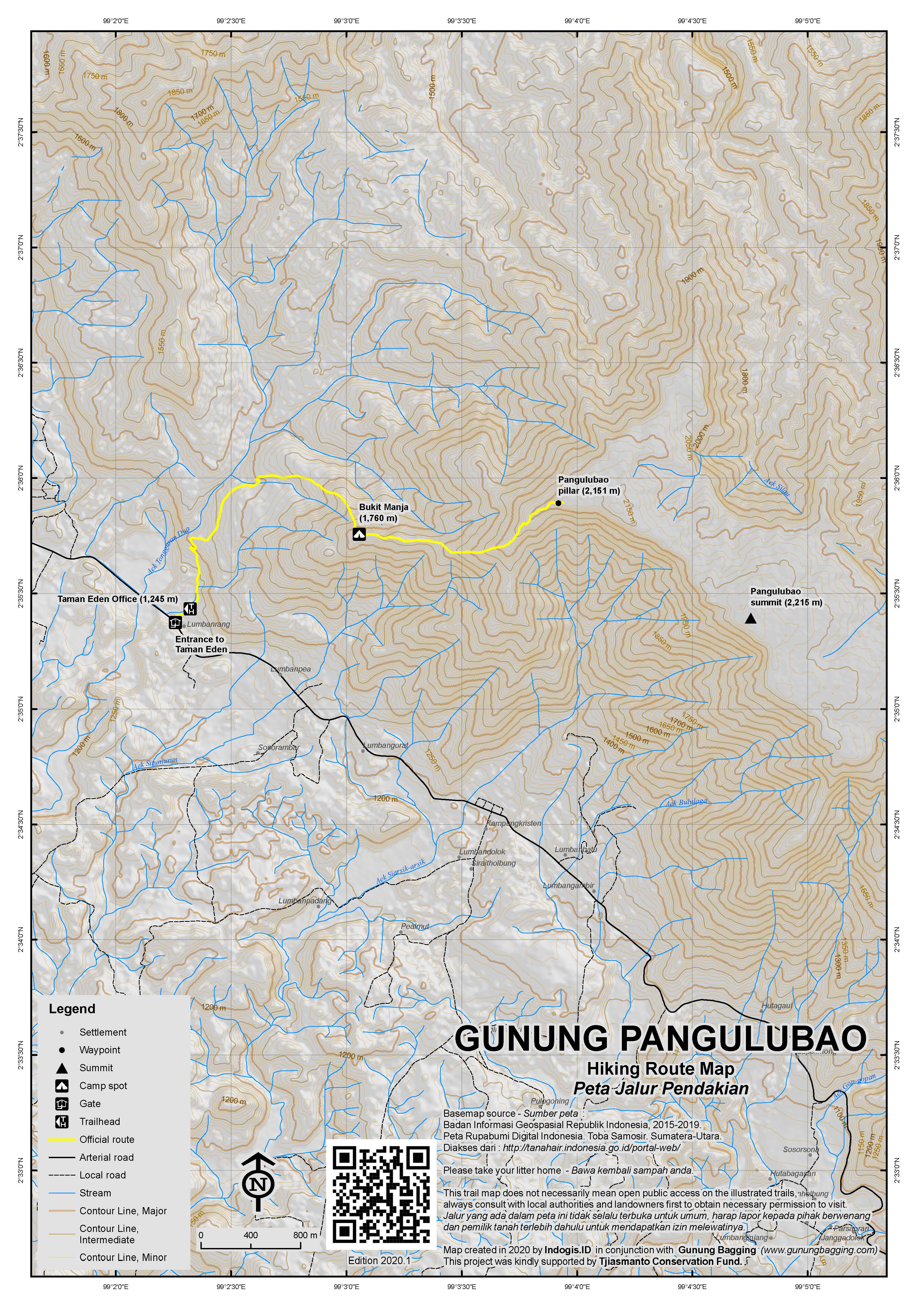
For a high quality PDF version of this and other trail maps, please download from our Trail Maps page.
Local Accommodation
Practicalities
- Getting there: You can easily arrange transport to Taman Eden from Parapat, and it is better to either chart an angkot or colt (public minibuses) or take one of them that regularly hurtle past Taman Eden towards towns at the southeast corner of Lake Toba. The entrance to Taman Eden is well marked and the car park and conservation office are only 30 meters from the main road. For getting between Parapat and Medan, there are lots of buses but the best thing to do is book a seat in a shared car (Rp 70,000 each) arranged by Bagus Taxis (Parapat office near the ferry) which run every hour or so during the day. For those flying into or out of Silangit Airport south of Lake Toba, you can catch a minivan (Rp40,000) to/from the main road at Taman Eden to/from the airport road junction or hire a car and driver for the 1hr 30min journey (Rp400,000).
- Guides and GPS Tracks: Want a PDF version for your phone? Looking for a guide? Need GPS tracks and waypoints? Gunung Pangulubao information pack can be downloaded here.
- Trip planning assistance: Would you like Gunung Bagging to personally help you in arranging your whole trip? Please contact us here.
- Permits: None required but take a photocopy of your passport photo page just incase.
- Water sources: None available. Take sufficient supplies with you.
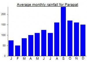
Local Average Monthly Rainfall (mm):
Location
Origins and Meaning
The mountain of village chiefs (Geleng, guide from Brastagi, 2011)
nice
its reaally great treking,reall treking.
thanks for your information.
i was hiking in this forest too.
very natural
i really interest to hike in pangulubao as your information above. maybe after i going to pusuk buhit ‘the beginning of bataknesse people. you should go ther because the scenery was great and beautiful. thanks for your information about pangulubao 🙂
salam LESTARI
This was the final of 3 peaks I climbed last week. After Sibuatan, I had another night down in Tongging before arranging Bagus Taxis to pick me up at Sipiso-piso waterfall. The car was late, but then it was Hari Raya and sharing a vehicle with a few other tourists heading to Tuk Tuk from Bukit Lawang made a lot more sense than relying on public transport via Pematang Siantar. The direct route to Samosir is straight down the east side of the lake to Parapat. There are some superb views as the roads winds its way along, above the vast expanse of water. I was expecting Pangulubao to be an easy, enjoyable hike and…. it was. I chartered an angkot to the entrance for Rp80,000 and had a chat with the family who run this rather prestigious conservation area. We set off shortly after first light and we were up at the Bukit Manja viewpoint in about an hour and a half. It was a grey morning but the view was impressive nonetheless. After a break for some beng-bengs we continued onward along the much narrower and less used trail beyond Bukit Manja. The trail was overgrown and apparently nobody had been up there all year – perhaps not since Andy and Gill climbed it in Feb 2010. There were less pitcher plants than I expected (I saw far, far more on Sibuatan). Looking at my GPS it seemed that although we were already above 2100m we still had a couple of kilometres to go to reach the highest point. All of a sudden the cement trig pillar appeared – quite unexpectedly. It had only taken us 3 hours to get here, including a good rest at Bukit Manja. Anyhow, I felt that something was not right. The GPS gave a reading of about 2150m and I switched it off and back on again several times and got similar readings. It was previously thought that the pillar marked the true high point of Pangulubao mountain but my GPS told me according to Google Earth we were still 1.8km off. A long distance to cover in the terrain we faced. I could tell the guide had never been there and definitely wasn’t keen on trying! He said this really is the top and nobody really goes beyond here. The reading of 2150 made sense given that Pangulubao is often quoted as being 2150m high. But we had found another, less frequented part of the mountain (if ever frequented) that was approx. 2199m. Only 49 metres difference, but the difference between Pangulubao being a Ribu or not. Anyway, I decided to just enjoy the hike and look into things on my return.
On the descent the weather cleared up dramatically and the view back at Bukit Manja was gorgeous. Lower down, at around 1500m, we saw some black gibbons leaping through the tree tops but they were too quick to get a good photo of.
I was a bit disappointed, and so was Andy when I sms’d him to query the summit location. It would appear that nobody has been to the true summit before in recent decades, although there is of course a chance that a different route up from further south may exist. It’s a great hike from Taman Eden to the trig pillar, but to reach the highest point and make it back before dark is probably impossible. It would be a 2 day expedition and it’s difficult to estimate just how tough and dense the terrain would be. If anyone knows of a route from further south then do let us know…. for now, however, Pangulubao is yet another Indonesian mountain which can be added to the list of ‘very difficult to bag’!
I got an ojek back to Parapat for RP 50,000 just outside the entrance.