
Facts
- Elevation: 1,667 m (5,469 ft)
- Prominence: 1,107 m
- Ribu category:
 Kurang Tinggi
 - Province:
 Jawa Timur (East Java)
 - Coordinates: -7.9754, 113.3463
- Rating:

 (7 votes) Add your rating
 Loading...
 - Other names: Lemongan
- Eruptions: 1799, 1806, 1808, 1817-18, 1821-22, 1824, 1826, 1829-30, 1838, 1841-44, 1847, 1849, 1856, 1859, 1861, 1864, 1869-72, 1874, 1877, 1883-91, 1893, 1898
- World Ribus ID: 69173
Photos


Bagging It!
Gunung Tarub is the name given to the highest peak of Lamongan mountain. It has not erupted since 1898 but used to be one of Java’s most dangerous volcanoes. The mountain is surrounded by 27 maars – low-lying volcanic craters, some of which are now lakes. Despite its relatively low height, Lamongan has the characteristics of a much larger volcano.
Lamongan is fairly frequently climbed by local students and hikers who like to reach the fascinating, eerie crater. The closest town is Klakah which lies to the west of the mountain on the main road between Probolinggo and Lumajang. From Klakah, follow the road east to Ranu Klakah (one of the lake-filled maars) and on to the village of Papringan (281m). When you reach a fork in the road with a security post in the middle, take the left turn and follow this increasingly bumpy road for another 2 kilometres. Although you will have to drive slowly, the road is passable by ordinary motor vehicles or you can alternatively get an ojek from the main road in Klakah. The road ends at the impressive home of Mbah Citro (455m). It would take about an hour to walk here from Klakah.
Mbah Citro is an affable gent who claims to be 108 years old and built his house here in 1964 after moving from Semarang. He and his extended family are happy for people to rest here and they will prepare basic meals for you if required. The house itself is very eccentric indeed – it has been entirely ‘wallpapered’ in electronic circuit boards – thousands of them! There are also various photos and posters of Mbah Citro in formal dress and quotations from former president Sukarno. There are many date stones set into or written on the walls of the house, indeed a new one was going up the day we arrived to commemorate Mbah Citro’s 46th year of residence here! It is very useful to have a local guide because most people here speak Javanese much moreso than Bahasa Indonesia, never mind English. This area is one of great importance to traditional and local religious beliefs.
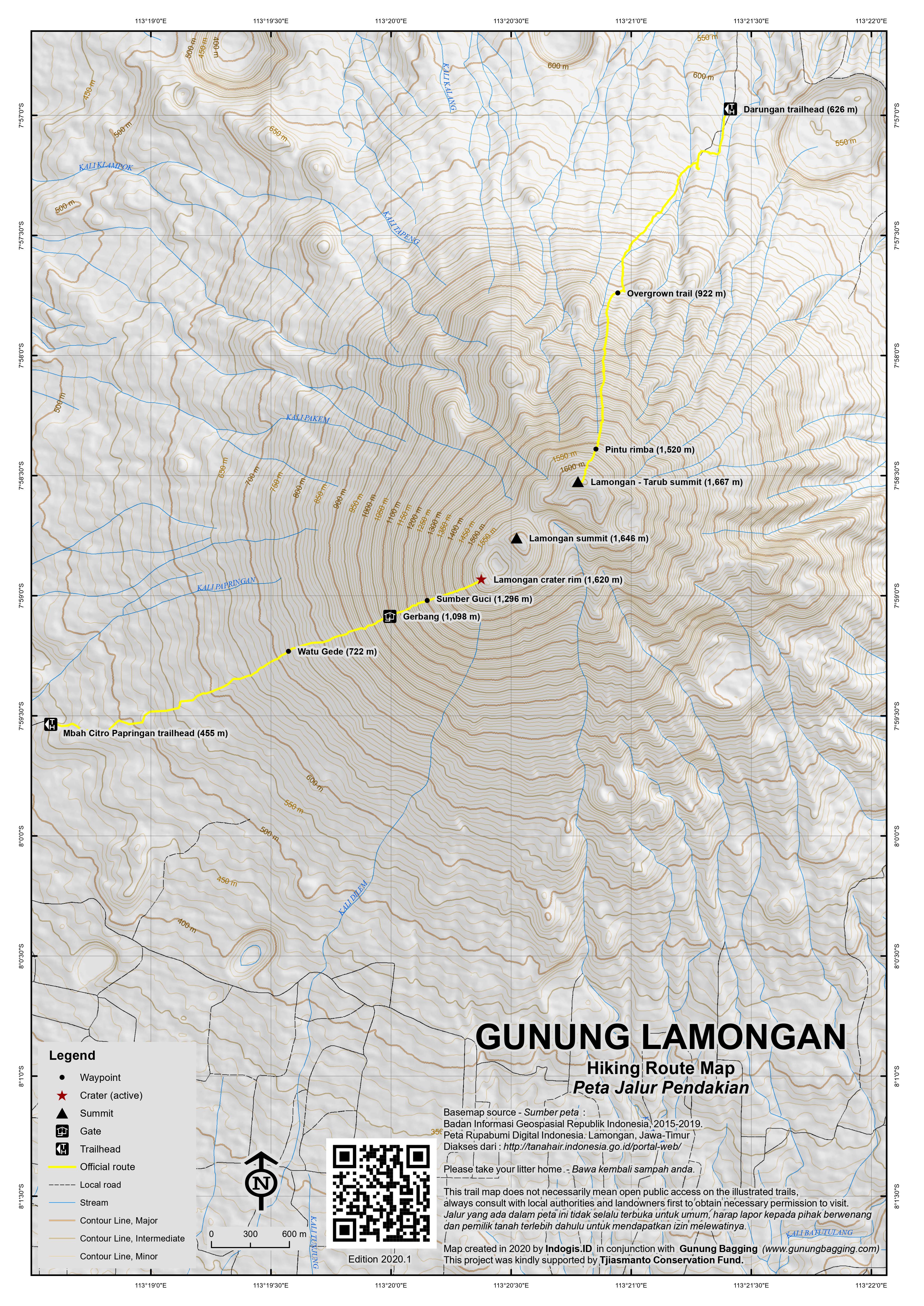
Outside the house the landscape is a mixture of pleasant green foliage and sharp, black volcanic rock, hurled down the side of the volcano in previous centuries. The trail starts at the back of the house and leads gently up the open hillside. Because there is little shade on the lower slopes of the mountain it is a good idea to start as early in the morning as possible to avoid the worst of the heat. There are several trails on the lower slopes but most of them join up before Pos 2 Watu Gede (722m) – a large rock with graffiti all over it where hikers often take a rest. It only takes an hour to reach this point. After Watu Gede, the trail heads straight up the side of the volcano and the terrain begins to resemble a much-less steep version of the final section of the climb to the summit of Semeru. The ground is covered in layers of black volcanic sand and small rocks.
At an elevation of approximately 1,098m (Pos 3 – Gerbang), the trail enters forest and finally some shade from the sun is available. At 1,296m is a ceramic bowl (Pos 4 – Sumber Guci) which contains water believed by local people to have special properties. Take extra care to check your hands and feet regularly because there are many leeches in this section of the hike. The trail becomes even steeper after this point but it is a well-defined path and difficult to get lost on. Eventually the forest becomes less dense and you should have some excellent views westwards towards Semeru and Bromo. Altogether it should take about 4 hours to climb from Mbah Citro’s house to the crater rim.
The rim of Gunung Lamongan is an incredibly atmospheric place – large boulders crown the side of the rim accessible from this route. Some of these rocks are hot and there are many places on the side of the crater where you will see a great deal of sulphur gases rising into the air, especially on the western side. The crater itself is remarkably deep – perhaps 150 metres) and there are some fantastic rocky pinnacles and precipices. It is also quite a dangerous area so take extra care to mind your step and also avoid breathing in any of the gases. You should have fine views of Gunung Argopuro which is the next major mountain range to the east. This point on the rim of Lamongan is as far as most hikers go before turning around and heading back down the trail to Mbah Citro’s house.
Although most hikers are happy enough to enjoy the incredible atmosphere of the mountain and the views, the summit itself lies a considerable way beyond the crater. The regularly visited section of the rim is at an elevation of approximately 1,620m although the highest point of the rim (on the northern side) is 1,646m according to Bakosurtanal maps. Unfortunately, the terrain is incredibly steep, hazardous (immense drops and sulphur gas) and there is no route through the vegetation which covers the sharp rocks. Reaching the very top of the rim is a considerable task which people rarely undertake. It could probably be reached in about one hour (assuming you have the confidence required). Following the rim clockwise is the easier option but neither are easy.
In addition, as if this were not hard enough, the highest point of the mountain, known as Gunung Tarub (1,667m), is a forest peak which lies a further kilometre to the north-east! Tarub is covered in dense vegetation and there is a considerable drop – think of it as a small valley – between Tarub and Lamongan crater. Local hiker Iwan Erfanto of Probolinggo made a 3-day expedition to Tarub from this side in October 2008.
For those without lots of spare time and who want to reach the highest point, Tarub, the best thing to do is climb from Kampung Darungan (626m) near Ranu Gedang to the north of the mountain. It is only very occasionally climbed from this direction and so you will almost certainly need to enlist the services of some local people to help cut down the undergrowth and locate the actual path! From Probolinggo it takes about an hour to reach Ranu Gedang where you take a right (i.e straight ahead) up to the final village of Kampung Darungan. The road up to the village is simply a very bumpy farm tracks for several kilometres and not something a regular car could negotiate without a lot of effort. A jeep would be ideal otherwise you would have to arrange ojeks or simple walk in for an extra hour or two.
Gunung Bagging went there in January 2011 and it took just 5 hours from Kampung Darungan to the summit – which offers little in the way of views but is crowned with a cement surveying pillar from Dutch times and under 3 to descend the same way. There are some stunning views of ancient outer craters – evidence of what a complex volcanic area this once was and may very well be again. Just look at the area on Google Maps to see all the circular depressions – volcanic ‘maars’ – in the landscape.
In summary, the highest peak of Tarub is best approached from Ranu Gedang to the north but the more interesting Lamongan crater is best approach from Klakah. Both of these hikes can be completed in a single day and both are really worthwhile. To do a traverse of both peaks in a single day would be pretty difficult – you would need to set out before dawn, hope that someone had been up recently and so made the trail clear, get very lucky in route finding and also negotiate the tough section between Lamongan crater and Tarub which takes about 2 hours and goes via a peak known to local hikers as Gunung Candi, named because it resembles a temple not that there is actually one up there! Otherwise, take it steadily, spend two days doing a traverse and enjoy a night on this atmospheric mountain.
Bagging information by Daniel Quinn.
Trail Map
For a high quality PDF version of this and other trail maps, please download from our Trail Maps page.
Practicalities
- Getting there: For domestic flights from or to East Java, such as the airports in Surabaya, Malang and Banyuwangi, we recommend Baolau. The nearest city is Probolinggo. There are buses towards Lumajang via Klakah. Getting to Kampung Darungan is more difficult and would probably involve ojeks or a jeep.
- Guides and GPS Tracks: Want a PDF version for your phone? Looking for a guide? Need GPS tracks and waypoints? Gunung Lamongan information pack can be downloaded here.
- Trip planning assistance: Would you like Gunung Bagging to personally help you in arranging your whole trip? Please contact us here.
- Permits: Mbah Citro may have to contact the spirits first to see if it’s ok for you to climb. Take a photocopy of your passport photo page just incase.
- Water sources: Take sufficient supplies with you.
- Accommodation: Try the Booking.com map above or use this link to search for suitable hotels, homestays, resorts and apartments for your trip.
- We recommend Safety Wing as travel insurance for overseas travellers and tourists hiking up to elevations not exceeding 4500 metres.
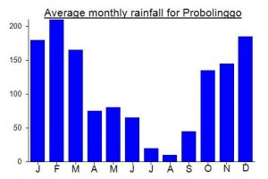
Local Average Monthly Rainfall (mm):
Location
Click on the blue arrow ![]() (top right) to see your current location on the map
(top right) to see your current location on the map
Origins and Meaning
Gunung Tarub = (possibly) Mount Blacksmith’s Workshop. One of the main meanings of tarub in Old Javanese is “the shed/shelter where a smithy or blacksmith works”. So Gunung Tarub might be so named because Lamongan crater is hot and firey like a blacksmith’s forge (see also Gunung Papandayan). In modern Javanese tarub has widened in meaning to signify the temporary shed/shelter built at the front of a house to accommodate guests at a wedding celebration. (George Quinn, 2011)
Rob W climbed the highest peak Tarub this week. https://www.peakbagger.com/climber/ascent.aspx?aid=3016400
His guide is probably a good bet. Mesnawi (+62 823-3759-8367 WhatsApp)
A group of us hiked this as an overnight lintas this past Friday night to Saturday morning. What a beautiful way to do it!
We set off from Basecamp Mbah Citro about midnight on Friday night – following behind and eventually overtaking a group of about 25 local high school students who were the only others on the mountain that day. 30K/person entry, as well as admiration from the guy that runs the place because he claims it has been 3 years since anyone even attempted a lintas.
The first hour of the hike was outside of trees and not super steep. After that we went inside the treeline and things got quite steep the whole way up. Near the top it felt like raining but I think it was actually just clouds rushing by and condensing on the trees – much of a muchness I guess because we still got wet.
Reached the crater rim at 4am, where we settled in for a nice long sunrise. The sun came up over Argopuro and lit up Semeru’s first few smoke puffs of the day, so it’s a stunning location.
After about two hours eating and chilling, we went up to what GunungBagging calls Lamongan Summit, but I think the guys at the basecamp were referring to it as Puncak Sejati, and they claim it’s the highest. Getting there involved a careful scramble along the crater rim and was definitely helped by our guides’ machetes. The rocks are dotted with sulfur vents, many of which are covered in plants and therefore might easily be stepped in. DO NOT go on this stretch at night, though it’s super awesome. After chilling at Puncak Sejati for an hour or so, we carried on across the steep and apparently not-often-crossed valley to Puncak Candi, before carrying on up to Puncak Tarub. Note that the bit between Puncak Sejati and Puncak Candi showed no signs of having a path prior to when we were there. So don’t go without guides who have done it before and are carrying machetes.
From Tarub, it took us about 3 hours almost entirely on rapid downhills to get back to a little kampung where we could get picked up. The last part is through beautiful farms. We didn’t find a basecamp per se but several farmers clearly had seen hikers before so knew what we were up to.
Overall, we were on the mountain for just over 12 hours (midnight to noon, roughly), though that includes about 2 hours chilling/cooking/eating at the place we reached the crater rim and another hour napping at Puncak Sejati. It’s a fantastic diverse range of scenery and a great vantage point from which to see Semeru, Argopuro, and beyond.
An over-the-top headline perhaps, but activity has certainly risen considerably this month.
https://en.tempo.co/read/1272092/mount-lemongan-explodes-pvmbg-records-254-local-earthquakes
Introduction. After my first preference East Java hike- a foray over Argopuro- was foiled by forest fires, I switched targets. Instead my mid term break travel objective became a triumphant traverse of the Tarub-Lamongan massif. As it turned out, this plan too fell through, as explained below, but I did manage to bag the summit of Tarub, which my GPS device reported as between 1671 and 1678 metres, matching the Nelles map height of 1671m.
Getting there. I took an early-morning Air Asia flight from Jakarta to Surabaya, then an airport taxi (40 minutes, Rp120,000) to Gubeng train station, where I caught the Mutiara Timur Siang (2 hours, Rp115,000) to Probolinggo. (Actually, it would have been more efficient to catch the train at Sidoarjo station, which is closer to the airport than Gubeng is.) From Probolinggo bus station I took the big Situbondo bus (Rp8,000) and got off at Pajarakan, where I chartered an angkot (90 minutes, Rp100,000) to Kampung Darungan. Again this was inefficient; the best option would be to get off at Gending, where there is a turnoff with a big sign for Songa Adventure. From Gending, it’s 15km to Songa Adventure and a further 5km to Kampung Darungan (GPS altitude 616m).
Kampung Darungan. Although the last few kilometres of the road are pot-holed and bumpy, they are currently passable by angkot, right up to the top end of the village. Kampung Darungan was more prosperous than suggested by the access road, with 100 plus sturdy dwellings, many freshly painted, and festooned with cages to hold the song birds that must be a major local recreation. I got off at the first house, belonging to Pak Anis, who put me up for the night and sought out two friends as guides for next day’s hike. Supposedly, three guides are needed to deal with mysterious wild beasts, even without attempting a traverse to Gunung Lamongan, whose crater, my guides claimed, would be impassable even if we could find a trail across the deep valley that separates the two peaks. Having not reconnoitered the mountain from the Klakah side, I had no way to persuade them otherwise, so we agreed a reasonable price of Rp1,050,000 for a two day hike to the summit and back, including ojeks to take us up to a start point at 878m.
The ascent. Setting off at 07.00 the next morning, our motorcycle ride lasted for 20 minutes through coffee and avocado plantations to a thatched farmer’s shelter where we parked the bikes. This starting point was not ideal as we had to hack across an unpleasant ridge of thick elephant grass from the parking spot to get onto the proper trail, which heads up the left side of a deep lava trench on the mountain’s north face. It’s steep and rough, with thick grass, but hardly any trees to offer either shelter from the sun or a secure handhold, forcing hikers to clutch at straws, or any other vegetation, to help on the steeper sections. While resting under one of the few trees, we did manage to find a wild beast, but it was only a 50 centimeter snake, probably a common house snake (lycodon aulicus). Finally, at 1520m altitude we entered the shade of the montane forest. The top section in the forest is straightforward when heading up, but mark your entry point carefully, as finding the correct exit back onto the grassy trail on the way down is more difficult.
The summit. About 5 hours after leaving the village, we emerged on the summit ridge at a campsite, which has soft soil and space for three or four tents. The summit pillar is thirty meters to the right, with a metal plaque marking a probably inaccurate 1651m and views through the vegetation to Gunung Lamongan. The path to the left reaches a viewpoint after about 5 minutes with open views toward both Argopuro to the east and Lamongan to the west. Reportedly, this trail descends all the way to the village of Tiris, which has public transport connections, but the ascent starting from there takes at least 7 hours.
Batu Candi. Continuing beyond the summit pillar for about 30 minutes, we reached Batu Candi (1597m), which overlooks the wooded valley, over 200m deep, and eastern slope of Gunung Lamongan, but there’s no hint of volcanic activity from here. Note that there’s a tricky vertical climb of about 6m just below the summit of Batu Candi; but you would not have to pass this to reach Gunung Lamongan as the path into the valley turns off to the right just before.
Descent. We camped overnight, with recurrent showers in late afternoon, but a clear sky for sunrise next morning. Bromo-Semeru can be seen from the summit area behind Gunung Lamongan. During the descent, we spied Arjuno-Welirang at several points, while also scoping out the beautiful sunbirds, flowerpeckers and other birds that are surprisingly active here even during the day. Another interesting feature is the array of volcanic maars, some dry but others filled by lakes, strewn over Tarub’s lower slopes and approaches. After 3h30 minutes we reached Kampung Darungan, from where I took an ojek (30 minutes, Rp100,000) down to Gending. followed by a colt (Rp10,000) back to Probolinggo.
Probolinggo travel tip. D’Bell Pepper restaurant in Probolinggo, close to both the Bromo Park and Tampiarto Hotels, has good pizza and cold Bintang. Train travellers can note that there are regular trains stopping in both Leces, which could be a jumping off point to Kampung Darungan, and Klakah, the access point for Gunung Lamongan.
Dear sir,you can try hiking to mt.Lingga,mt.kembang,mt.Setran(Bromo).there ia very Special view of peak
More info or guiding please contact me Iwan erfanto 085232600118 or email iwanerfanto@gmail.com
Yesterday myself, Iwan Erfanto and friends and a couple of local chaps from Kampungan Darungan near Ranu Gedang successfully reached the true summit of Gunung Tarub, which is crowned with a cement pillar assumed to be from the Dutch era. It was very overgrown and we had to cut through the undergrowth for much of the way, but local people do climb it occasionally, most recently in 2008. A local chap also mentioned that he recalled some foreigners making an ascent a couple of decades ago – Java Lava probably. Whereas the approach from Mbah Citro’s house to Lamongan crater has an aura of eccentric spirituality, the friendly people of Ranu Gedang are much more ‘down to earth’. Because of the ongoing Bromo eruption, we could taste the ash on our gums and there was a light coating of dark brown volcanic sand on much of the foliage from about 900m or so. There are some amazing views of ancient outer craters, some of which are almost perfectly circular. It took us 5 hours to reach the summit and less than 3 to return, though it could be climbed more quickly at the moment while there is a fresh trail through the undergrowth.
Whether you enjoy a hike or not can depend to some extent to the people you climb with – this bunch were really great and I wholeheartedly recommend anyone wanting to explore this mountain to contact Iwan Erfanto – 081334 917993 or email iwanerfanto@gmail.com. Probolinggo is the best base. Updated bagging information coming shortly…
My new number WhatsApp 082337779666 thx
VISIT MY BLOG http://www.rangerart.blogspot.com
for a new information of mountaineering
e-mail me : erfantoiwan@yahoo.com
Thanks bro…!!!
Dear
Mr.Daniel Quinn
I’ve seen your picture with MBAH CITRO, but not clear enough.
I will enjoy to guiding you for climb to mount Lamongan-tarub next year.
Better to climb mount Tarub from mount Lamongan, because you can reach 5 peaks at one trip (Lamongan’s peak, Trully peak of Mt.Lamongan, Candi’s Peak, Tarub’s peak, and Suket’s peak.We just need 3 days to complete the ekspedition.
January or February is best momment for you to hiking
Call me if you interest! Ok
I have travel for wild Adventure “SAVANA EXPLORE AND ADVENTURE”
Don’t worry,about the payment. I give you special price for special adventure to mount Tarub!
nice to see you….!!!
Managed to get to the crater rim yesterday – a fabulous place to watch the sun rise. No chance of reaching the summit of Tarub though. Funnily enough, just hours later I got an email from Pak Irwan who led the 4-day expedition to Tarub via Lamongan in October 2008. The only group to have done both in the same expedition. See http://rangerart.blogspot.com/2010_08_01_archive.html
I hope to return next year sometime to try a separate climb of Tarub, probably from the north. Apparently there is a farmer’s trail from Desa Gedangan, but not all the way to the top. These small Ribus always seem to be the hardest.
Hello gaess….
Hope I can help you to manage or guiding for climbing to this mountain
Contact me @ iwanerfanto@gmail.com
Or Wa 085232600118
Base camp Probolinggo
Thx
I was hoping to climb this mountain today with a local guide but was informed that people would not climb Lamongan due to ‘magic in the area’.