
Facts
- Elevation: 1,391 m (4,564 ft)
- Prominence: 1,029 m
- Ribu category:
 Kurang Tinggi
 - Region:
 Peninsular Malaysia
 - Malaysian state: Pahang
- Range: Banjaran Pantai Timur
- Coordinates: 4.3033, 102.9175
- Rating:
 (Bagged it? Be the first to rate it)
 Loading...
 - World Ribus ID: 68707
Bagging It!
Not much is known about this mountain at present though it has been hiked on a small number of occasions including in July 2023 via Felda Cerul (south of the mountain) over the course of 4 days. 4WD essential. There is a metal beirut at the top and some areas with lower bonsai vegetation.
Practicalities
-
- Getting there: For Malaysian domestic flights and flights within Southeast Asia, for example to Kuala Lumpur, we recommend Baolau.
- Permits: You can register and pay for an e-Permit online from the Forestry Department of Malaysia website. RM10 for locals and RM30 for foreigners (in 2024).
- Water sources: Unknown
- Accommodation: Try the Booking.com map above or use this link to search for suitable hotels, homestays, resorts and apartments for your trip.
- We recommend Safety Wing as travel insurance for overseas travellers and tourists hiking up to elevations not exceeding 4500 metres.
Local Average Monthly Rainfall 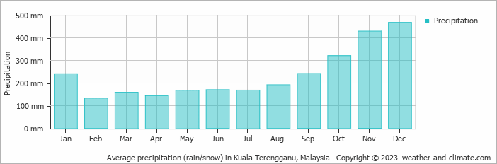
Location
Click on the blue arrow ![]() (top right) to see your current location on the map
(top right) to see your current location on the map