
Facts
- Elevation: 1,741 m (5,712 ft)
- Prominence: 1,558 m
- Ribu category:
 Kurang Tinggi
 - Province:
 Kalimantan Barat (West Kalimantan)
 - Coordinates: -0.4242, 111.2958
- Rating:


 (5 votes) Add your rating
 Loading...
 - World Ribus ID: 69077
Photos


Bagging It!
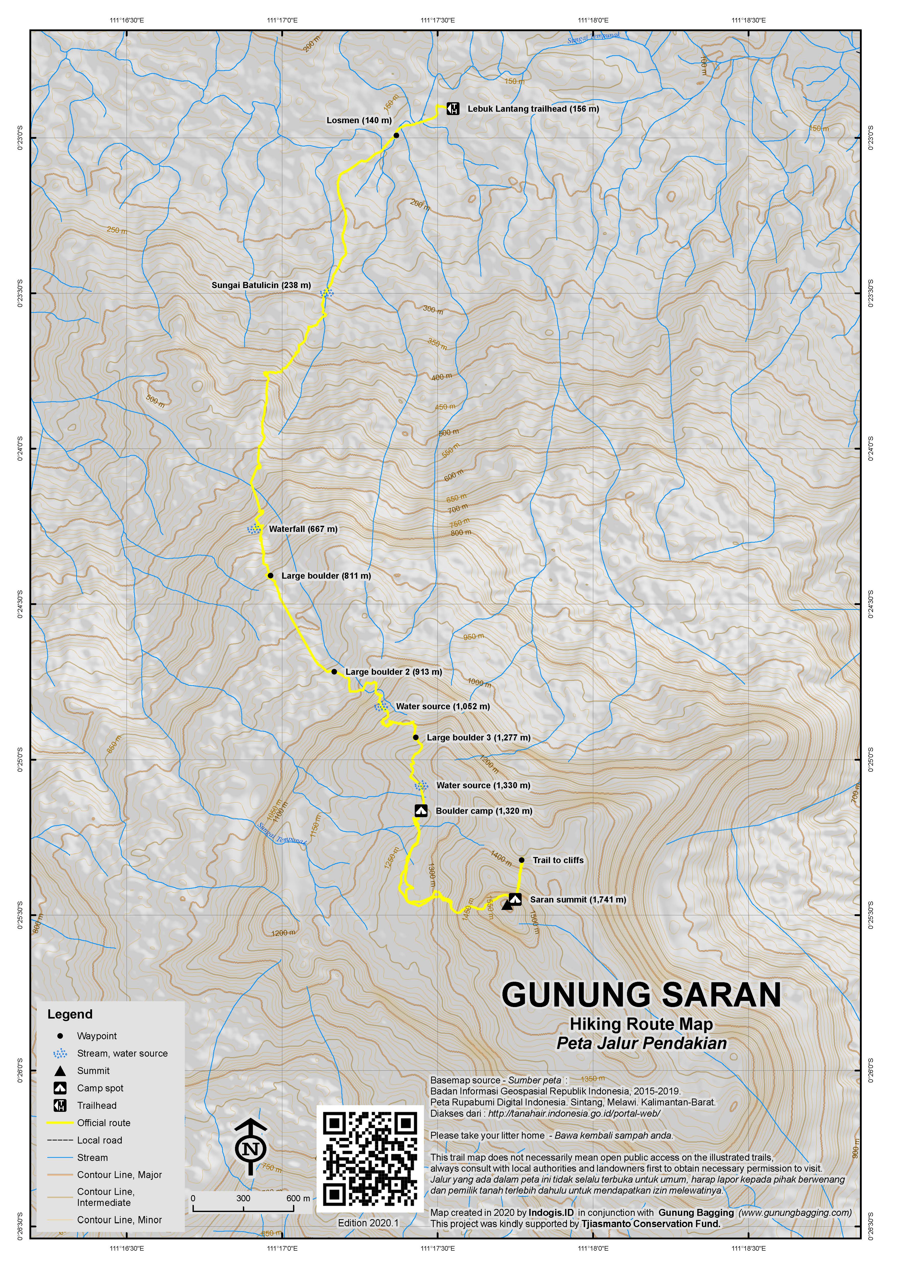
Gunung Saran, or ‘Bukit Saran’ as it is known locally, is a very attractive mountain from below, with steep almost-vertical cliffs near the top. However, because of the very flat land that surrounds it which is largely used for oil palm plantations, Bukit Saran, and also the lesser peak to the north known as Bukit Kujau (1,308m high), can rarely be seen from the main roads near Nanga Pinoh and Sintang. There is at least one trail to the summit, but it is vague in places and you definitely need local help.
Although it looks close on a map, the usual starting point at Lebuk Lantang, Riam Batu, takes over 3 hours to reach by motorbike (or possibly 4WD if you knew the route) from the oil palm plantation junction called Simpang Pandan, close to Sintang’s new airport. The first part of the journey is along dusty (in the dry season) plantation tracks and this could be very slow going in the rainy season so best not attempted. There are few signs, but lots of junctions, so you need local help in even finding the trailhead itself.
Once through the plantation you will find yourself at the village of Ansok.From this point on, the villagers are very anti-sawit (oil palm plantations) and are trying to build tourism (such as the hike up Gunung Saran) as a more responsible means of earning money from the local area. The track from this point is very bumpy as it follows the Tempunak river towards Riam Batu, which is the gateway to Gunung Saran. However, you should get some pleasant glimpses of the mountain itself. Once past the Riam Batu entrance markers at the side of the track, it is still a considerable distance to Lebuk Lantang at the end of the track (Ulu Tempunak) and therefore at least another 30 minutes.
Lebuk Lantang (156m) has a large field or ‘alun-alun’ in the middle from where you can look up towards the summit cliffs.There is also a village shop selling very basic items, but you will need to have brought your main supplies from elsewhere. It is crucial to get an early start as this is a very hot hike, starting at such a low elevation. There are leeches, though in the dry season there are less of them around or behaving aggressively.
The trail leads along a cement pathway beside the river and past the two new large buildings used for accommodation for hikers and those visiting local waterfalls (Rp 50,000 per person per night, based on several sharing a room together plus additional food costs). Just a few minutes beyond this is the crucial junction into the forest on the left which is not signposted but all local guides will know it.
The trail soon reaches a clearing with good views of the peak before re-entering steep forest. The Sungai Batulicin (river) is soon crossed (238m) and you should hear the flapping wings of hornbills above. There are many huge overhanging boulders on this trail which offer excellent protection from rain, should there be any. There is also a beautiful waterfall (667m) just less than halfway up to the camp spot. There are plenty of water sources as far as the Camp spot but in the dry season they may just be sitting pools of water so you may want to boil it first.
The customary camping or sleeping area (as you don’t necessarily need a tent due to the protection of the rock) takes around 6 hours to reach from the trailhead. This spot is at an elevation of around 1,320m and there are a couple of pretty old chili plants growing there so it has clearly been used for many years. As is the custom for many mountains in Kalimantan, your Dayak guides will want to conduct a good luck ritual for the hike, basically consisting of the slaughter of chickens for a meal for everyone, plus daun siri and pinang, which you are supposed to pay for. They will also make an offering cup out of the base of a bamboo stem and fill it with chicken, rice and a cigarette or two. This will probably be hung up on a branch at camp, and they may also take one up to the summit.
From the camp spot to the summit is another 90 minutes. As usual, it is best to try to get to the summit as early as possible the next morning, but your guides may insist on preparing and eating the ritual meal if they haven’t done it the previous night. The very last 15 minutes of trail is in moss forest with one or two pitcher plants and finally some cool breezes. Then you will see the small wooden hut at the top next to numerous small communications towers.
Part of the vegetation at the summit has been cleared so if you are lucky with the weather then you should have a reasonable view. To the right it a minor trail up from the Nanga Pinoh side which doesn’t seem to be nearly as well-used as the main trail. Over to the left at the end of the clearing is a sign from a Pontianak university hiking club expedition here back in 2008 with a height given as 1,741m which sounds reasonably accurate. Your guides may wish to make further offerings here.
In clear weather, consider trekking beyond the expedition sign for 10 or 15 minutes to a viewpoint above the cliffs. There are many pitcher plants here and the views are said to be good.
Back down to camp takes an hour or so, and then it is a further 4-5 hours down to the trailhead.
This mountain could be done in 4 days from Jakarta if you could reach the trailhead on Day 1, hike on Days 2 and 3, and have reliable transport to get you out to the new Sintang airport (alllow 4 hours) early on the morning of Day 4.
Bagging information by Dan Quinn (August 2018)
Trail Map
For a high quality PDF version of this and other trail maps, please download from our Trail Maps page.
Practicalities
- Getting there: Sintang is the closest airport – but still over 3 hours by motorbike from the trailhead.
- Guides and GPS Tracks: Want a PDF version for your phone? Looking for a guide? Need GPS tracks and waypoints? Gunung Saran information pack can be downloaded here.
- Permits: You will almost certainly have to take a local guide from Lebuk Lantang and pay for local chicken.
- Water sources: Available at the waterfall (667m) and limited supplies as far as the camp spot (1,320m).
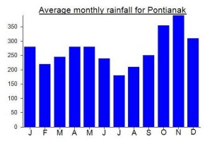
Local Average Monthly Rainfall (mm):
Location
Click on the blue arrow ![]() (top right) to see your current location on the map
(top right) to see your current location on the map
Just like with Bukit Raya, this peak is usually simply called a hill (bukit) when in reality it definitely feels like a mountain. I was having trouble finding anyone who could take me there, as just getting to the trailhead is time-consuming and potentially very expensive for a single traveller. I tried online, and asked in outdoor stores in Sintang. It wasn’t looking good, despite one or two leads. Even locally, not many know if the mountain – even the Bukit Baka Bukit Raya park staff in SIntang only knew of it vaguely because of a plane having crashed there in 1993/1994.
And then by chance I found a post on Facebook by a local man called Yosep from Benua Kencana (Ansok area) who was planning on climbing it for Indonesian Independence Day (Aug 17th). This was ideal so I got in touch with him and asked to join. I was in Nanga Pinoh at this stage, resting after the Bukit Raya hike, and trying to find anything half-decent to eat that didn’t contain meat.
Anyway, he said that I could certainly join so we arranged to meet at SImpang Pandan, the entrance junction to the palm oil plantation very early on 16th. Pak Su, a very friendly driver from Pinoh took me there and is a very good contact to have in the Pinoh area (his number is 082150375757).
I had no idea quite how far it was going to be from Simpang Pandan, and assumed Yosep had come from Sintang, when in fact all the other hikers where from much closer to the mountain such as the Ansok area. They had already arranged guides locally.
When we finally got to the trailhead, the guides were obviously shocked to see a foreigner coming along, and I felt somewhat uncomfortable and could guess that the guides wanted more money now that a ‘rich foreigner’ was joining. Luckily, that didn’t come to pass, it remained affordable for all, and we got on alright eventually, but they don’t half know how to make you feel unwelcome sometimes as a foreigner. I put in Rp400,000 towards the sacrificial chickens etc etc.
The hike itself destroyed me. I was the only one with a large backpack, which Yosep helped me with, but regardless of the weight of the pack I was absolutely roasting. It wasn’t until I got back to SIntang afterwards that I checked the temperature and it had been a ridiculous 37 degrees. No wonder I found it so difficult.
We weren’t hugely lucky with the weather and had no real views from the top as they hoisted the Indonesian flag up and sang the anthem the following morning. If so much time hadn’t been spent on the ritual meal perhaps we would have been up to the top before the low clouds arrived. But it wasn’t to be. The horrendous haze blanketing much of West Kalimantan didn’t help much either – one of the downsides to visiting here during the dry season.
And once again, for a vegetarian it was tough going with the ‘obligatory’ chicken meal. Thankfully Yosep wiped a bit of cooked chicken on my wrist so that I didn’t have to actually eat any and I assumed the role of documenter rather than participant (it was after all Indonesian Independence Day). Offerings were made by the expedition sign from almost exactly a decade ago. This consisted of rolling bit of food in one’s hand and hurling it into the bushes whilst praying.
Some of the group decided to continue to the viewpoint above the cliff, some 10 or 15 minutes away. I set off with them initially, but with no water at the top and enough cloud to make a view impossible I soon returned and waiting for them by the summit clearing. GPS gave readings between 1733 and 1739m so the 1741m on the sign is probably more likely than the 1758m we used to have on the site.
There was a fair bit of pressure to stay at the village accommodation when we got back down, as it was going dark by them. Friendly folk and decent accommodation, apparently supported by an American chap who has links with the village. But I knew I would get no sleep lying next to 10 or more Indonesians (who never stop chattering) so I insisted on getting back to SIntang that night. The lads agreed, and we zoomed off back to Ansok first and then on through the palm oil plantations to SImpang Pandan and finally SIntang. A mammoth effort by Timo, who took me there on his motorbike, and one I paid him handsomely for. You would never get in and out of this area without local help as there are just too many junctions with no signs whatsoever. Good luck to them keeping the palm oil out of the areas closer to the mountain itself – if they can encourage more tourism it will surely help matters.
I had expected this one to be easier than Bukit Raya, but given the temperature I found it unusually hard going. The summit was a real disappointment given how great it looks from the villages below, but perhaps in good weather the views are worth it. Apparently Rafflesia are sometimes seen in this area so do look out for them!
Number for homestay: 0813 5128 4678 (Tya)
Number for Kepala Desa: 0823 5103 9478.