
Facts
- Elevation: 4,758 m (15,610 ft)
- Prominence: 2,756 m
- Ribu category:
 Sangat Tinggi
 - Region:
 Papua
Papua - Coordinates: -4.7087, 140.2894
- Rating:

 (10 votes) Add your rating
 Loading...
 - Other names: Aplim Apom in local Una language, Mount Juliana
- World Ribus ID: 80007
Photos


Bagging It!
Puncak Mandala is the highest peak in the Star Mountains and had an ice cap until very recently. Apparently, the usual trek to the peak begins in the village of Bime to the north of the mountain and follows hunting trails up a reasonably gentle incline. The first expedition to the summit on the route was made by a Dutch group in 1953. However, the approach sounds very difficult indeed – one Australian expedition failed to reach the mountain on this route in 1996. The approach from the south (via the South Face) is a lot more difficult in technical terms – it has only been successfully climbed from the south on one occasion in 1990 by Bruce Parry and Mark Anstice. It sounds very much like a route only suitable for experienced rock climbers. Ricky Munday is leading a party to attempt a second ascent via this route in December 2010. It will involve flying into Sumtamon and then trekking in for a week to the Eilanden River. After that they will rely on information provided by Mark Anstice and follow hunting trails used by men from the village of Tabasyk and onwards up the southern cliffs. Good luck Mr Munday!
Practicalities
-
- Getting there: See above
- Permits: Government permit required
- Water sources: Unknown
Local Average Monthly Rainfall (mm): 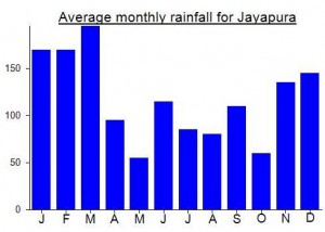
Location
Click on the blue arrow ![]() (top right) to see your current location on the map
(top right) to see your current location on the map
Origins and Meaning
‘Mandala’ means a magic circle or shrine built for meditation in Javanese. So, “Shrine Peak” might be a reasonable translation.
apakah anda rencana ada ke puncak mandalakah kalau ada rencana ke puncak mandala hubnggi say kedumans eli bime nmr kontak 081344010608k
Hello, i plan to do the same route next june july, as i am planning à long expedition, i would like to know if rope were necessary for the climbing, as i do not want an over load pack ?? Do you think there is a way out on the south west of the ridge ?? Also From eipomek did you pas the village of langda or did you follow the north ridge ? Thanks a lot for your help. Did you Drew a map of your climbing ??
Thanks
David
Ada mau datang ke puncak Mandala bisa lapor ke saya .atas nama.keduman eli.limbal Lim album papua.nmr.kontak.081344010608.email.elianuskeduman@yahoo.com.kedua pegunungan adalah milik sy.by keduman.eli bime Papua.⛏️
Two climbers from Latvia summited Mandala on March 20, unsupported. Trekked to mountain from Eipomek (NW), the most eastward village surat jalan was given for westerners. Bime, Sape, Oksibil –forbidden… “conflict, no-go”. We followed main ridge (crossed it twice), it took nine days and some 6 or 7 mountain passes to reach base (did new route from NW). Trekked alone, used local guides (hunters) only to show trails for two days at beginning, they do not know area above 3500 m… But interesting that there are vague trails above “hunters level”… geologists, military, who else???
After summit continued SE to Sape and Oksibil. Had big problems to find trails out, got out on morning of Day 17 only (Sape, after 5 h more trek + ojek ride (road) – Oksibil at evening).
At Oksibil where adviced not to mention Mandala 🙂 Nobody asked for surat jalan which we did not have 🙂
Used AMA to fly in (Eipomek) and out (Oksibil). There are regular Trigana flights to Oksibil as well (4 per day).
STATS: 17 days, 250 km by GPS (on map (Google Earth is the best available :)) it looks close to 80 km, air line). Mountain jungles + rain will get you. Extremely hard!!!
PS. Basic Bahasa Indonesia knowledge is must to complete trek like this on your own. I studied it online for two month before coming to Papua… Saya bisa menulis dalam bahasa juga tetapi info ini untuk orang-orang dari Barat 🙂
Hi.. could i get your GPS track of Mandala peak. i planning to going there but using a normal route from Bime, just for refference of the track.
Thanks
Ada mau ke puncak Mandala harus lewat bime ke puncak Mandala kembali jga lewat bime jgn lewat daerah lain yg punya gunung adalah orng bime perlu tau oke.
saya juga berencana ke mandala, bagaimana kalau kita buat team pendakian untuk menggapai puncak mandala, nomor kontak saya 085299960666
Dari info yang aku pernah temukan, ekspedisi Pak Steven tidak mengunakan jalur dari Bime atau mana pun, kelihatannya mereka mengunakan heli untuk sampai titik yang lebih dekat.
Ngomon-ngomon, boleh aku tau soal rencana pak Sugeng lebih rinci?
Terimakasih banyak!
Allo Steven,
Saya berencana mau ke Mandala bulan Maret-April ini, kalau dari Bime butuh berapa hari utk sampai ke puncak? Apakah betul ad gua dibelantara? Tks utk infonya
Ucapkan selamat, Steven!
Boleh aku tau soal Mandala? Dimana boleh dapat keterangan tentang pendakian kalian? Bagaimana jalurnya dari Bime boleh dapat di cari?
Saya baru pulang mendaki puncak trikora dan puncak mandala oktober 2013. tidak butuh technical climbing.
puncak mandala pernah didaki oleh tim wanadri tahun 1990 dan sukses sampai puncak
Saudarah saidarah datng mendski punca mandsla bayat sbsar riupiah dulh.
Saya berasal dari anak Tanime, kalau Bapak Perlu berkomunikasi mengenai wilayah gunung Juliana atau mandala silakan hubungi alamat diatas ini
Terimakasih atas kerja samanya
Hi.
Bapak Kurukna.
Boleh minta kontak sesuai alamat diatas tersebut.
Saya dalam pencarian informasi untuk daerah Gn.Mandala di pegunungan bintang.
Salam
Hi.
Bapak Kurukna.
Boleh minta kontak sesuai alamat diatas tersebut.
Saya dalam pencarian informasi untuk daerah Gn.Mandala
Salam steven
Hi Bapak Kurukna
Boleh saya minta kontak sesuai alamat tersebut diatas. Saya sedang mencari informasi ttg Gunung Mandala. Terima kasih
Salam.
A press release about Ricky Munday’s forthcoming attempt to climb this and two other Papuan giants….
FOR IMMEDIATE RELEASE
FORMER RUGBY CHAMP RICKY MUNDAY ARRIVES IN PAPUA PROVINCE – PREPARES FOR TREK TO PUNCAK MANDALA – FIRST OF 3 HIGHEST PEAKS HE HOPES TO SUMMIT IN SIX-WEEK CLIMBING EXPEDITION
London, November 23, 2010 – Ricky Munday, 33, today announced that he has arrived in Jayapura, Papua Province for his six week Australasia 3 Peaks Glacier Expedition. Munday will fly to Bime in the Star Mountains tomorrow morning from where he will start the trek to the base camp of Puncak Mandala (4,684m), the first of the three peaks he will attempt to summit during the six-week expedition. He will use porters from the Ngalum tribe to gain local support and reduce the risk of Papuan separatist groups interfering with his solo attempt to summit Puncak Mandala.
The other mountains, located in the remote Central Highlands in the Pegunungan Maoke Central Range, are Puncak Jaya (Carstensz Pyramid, 4,884m) and Puncak Trikora (4,730m). Munday will travel by light aircraft and trek through extremely remote and challenging rainforest to each base camp.
The six-week expedition has three objectives: to be the first to summit the three highest peaks in Australasia in a single expedition; to verify the extent of the ice-cap cover on each of the three peaks for climate change scientists at the Universities of Glasgow, Indiana and Texas A&M and the World Glacier Monitoring Service – and to raise funds for Raleigh, the youth programme.
Ricky will live on freeze dried food and cope with the ever present dangers of malaria, dangerous snakes and altitude sickness. Temperatures will vary dramatically from extreme heat in the rainforest to sub-zero temperatures in the mountains.
Ricky Munday, who played rugby for Glasgow Hawks, harbours an ambition to climb the three highest peaks on each continent. His achievements to date include completing the Marathon des Sables and organising and leading a two-man expedition to Khan Tengri (6,995m) in Kyrgyzstan. In 2008, he organised and led the Africa 3 Peaks Expedition, which attempted to climb Mount Stanley (5099m), Mount Kenya (5199m) and Mount Kilimanjaro (5895m) in 20 days. The project raised over £6,000 for a children’s home in Nairobi where Munday had spent 4 months working on secondment.
Slmt mlm Mr ricy mundey pss dimana dan apa kabar ini dgn Eli keduman dri Papua Indonesia perna ketemu di Papua Thun 2009 lyg lalu.slm ricy mundey
Mark Anstice actually wrote a book about his successful ascent. It’s on Amazon UK here
http://www.amazon.co.uk/First-Contact-Mark-Anstice/dp/1903070260
He also wrote a piece on the Guardian newspaper…
http://www.guardian.co.uk/world/2006/dec/23/indonesia.weekend7
and made a TV programme – “Cannibals and Crampons”
Some fascinating information on Mandala (+Puncak Jaya and Trikora) and a forthcoming trip by Ricky Munday here http://www.wideworldmag.com/features/indonesian-adventure
Kalau mau penelitian di pegunungan puncak Mandala dan puncak Yamin selakan kontak ke sy atas nama .keduman Eli bime papua.nmor kontak.081344010608.
selamat sre apa kabar turis turis dari mancanegara mau pun lokal;