
Facts
- Elevation: 1,496 m (4,908 ft)
- Prominence: 1,496 m
- Ribu category:
 Kurang Tinggi
 - Region:
 Papua
Papua - Coordinates: -1.7709, 136.4283
- Rating:
 (Bagged it? Be the first to rate it)
 Loading...
 - Other names: Gunung Sambrawai
- World Ribus ID: 80033
Bagging It!
This Ribu is the highest point of Yapen island. The height is taken from a US Army map. Gunung Sambrawai is a proposed name for it, taken from the local village.
Practicalities
-
- Getting there: Unknown
- Permits: Unknown
- Water sources: Unknown
Local Average Monthly Rainfall (mm): 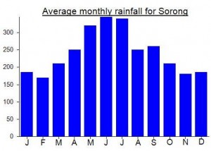
Location
Click on the blue arrow ![]() (top right) to see your current location on the map
(top right) to see your current location on the map