
Facts
- Elevation: 655 m (2,149 ft)
- Prominence: 655 m
- Peak category:
 Spesial
 - Province:
 Jawa Timur (East Java)
 - Coordinates: -5.7897, 112.6529
- Rating:


 (2 votes) Add your rating
 Loading...
Photos
")
")
")
")
")
")
")
")
")
")
")
")
")
")
")
")
")
")
")
")
")
")
")
")
")
")
")
")
")
")
")


Bagging It!
Gunung Besar is the highest mountain on the island of Bawean, which lies about 150km north of Surabaya in the Java Sea (about a third of the way to Kalimantan). It is very infrequently-climbed, but offers some nice views of the coastline and can be easily climbed in a single day. There are several endemic species here including deer ‘(rusa Bawean), owl (burung hantu bawean), eagle (elang bawean) and wild pig (babi kutil Bawean). Visitors will probably be surprised by the number of large bats seen at dusk. The many rice terraces make the island particularly photogenic. The main town of Sangkapura in on the south coast of the island and the airport is on the north coast near the second town of Tambak. The road which circles the island is approximately 55km in length and the island is about 15-17km in diameter.
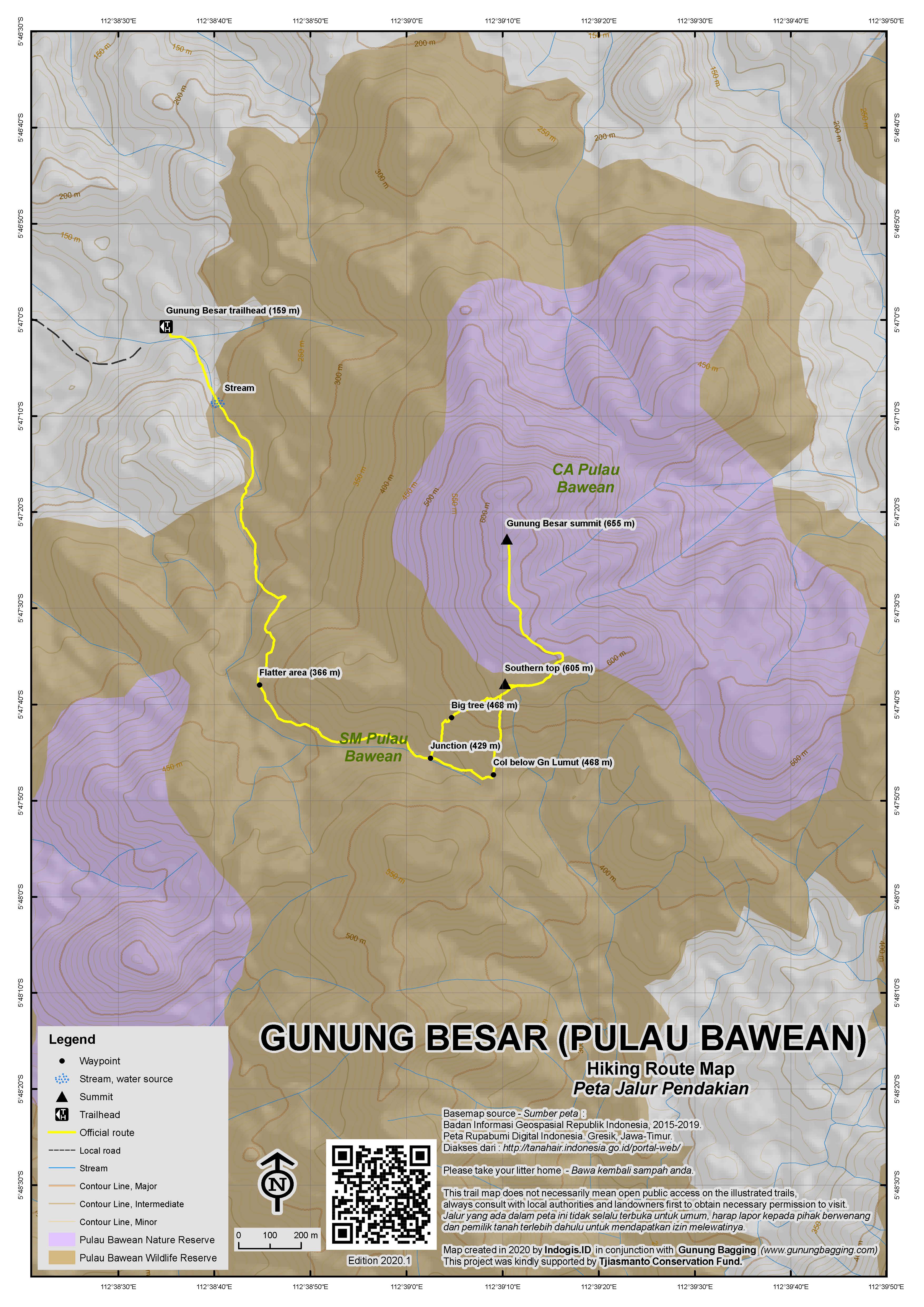
The best starting point for the hike is in the west, less than an hour by motorbike from Sangkapura. Follow the main road clockwise round the island, past Pulau Cina off the coast, and turn inland at the Desa Sumber Lanas entrance arch opposite a warung on the main road. Straight ahead you will see the mountain. You reach a junction for Desa Gunung Duren (right turn) but keep on going straight ahead and under a couple more arches. At the end of the road is a disused swimming pool (or perhaps just empty at the moment), a school and a mosque with a blue roof (159m above sea level). On the Bakosurtanal this is labelled Gunungduren / Desa Patarselamat. The peak is only just over 1km in a straight line from here but you will need to hike in an almost question-mark shape rather than head straight up the very steep cliffs.
The trail crosses the river and follows it and goes past an irrigation (‘irigasi’) sign and into forest. You pretty much follow and criss-cross the river for almost an hour as it snakes south and south-south-east. It leads up to a col between Gunung Besar and Gunung Lumut (‘moss mountain’), at 563m the 4th highest mountain on Bawean island. Up to this point the going is pretty easy as forest rangers did research here not long ago along with a European researcher. The col is about 468m above sea level and this is where the going gets tough as you turn left (NE) to head steeply up Gunung Besar (rather than heading right – SW – to Gunung Lumut). There is not much of a trail here and a machete is probably essential (unless anyone has hiked in the last couple of months). There are some steep sections where real care needs to be taken as it’s a long way down, and most of the plants have thorns on them making it difficult to pull youself onward.
Don’t be too concerned because after a tough hour of very slow progress you will reach a minor top on the southern end of the summit ridge of Gunung Besar. It is about 605m in elevation, or possibly a little under according to the Bakosurtanal map. From there you will see a higher top on the ridge further north, but instead of heading in a straight line towards it, you need to circuit round to the right (east) first, following the broad ridge. One landmark on our trip was a hole possibly lived in by porcupines (again, roughly 600m above sea level), which is where you can change direction and head north west towards the highest ridge of the mountain (and indeed of the whole island). There is another top southeast of the ‘porcupine hole’ but this is only between 610-620m according to the Bako map.
As you progress to the north, the ridge narrows, and in some places the drops are sheer on either side. This is also where the best views are to be had. There is a landslide area on the west face of the mountain at 640m and from here you can look out to the west coast, the little island of Pulau Cina, and lower hills. Interestingly, the Bako map has a spot height on the southern half of this summit ridge at just 638m above sea level, and whilst this may be accurate, several online sources state 655 or 656m as being the true highest point. Indeed, further north we had a GPS reading of 658m at one point and then 660m on a knoll which had been previously marked by hikers with a piece of material some years ago. 660m is easily within the standard 10m margin of error of the 655/656m published summit height so we are leaving our listing of Gunung Besar as being approximately 655m high, despite the missing contour lines on the usually accurate Bako maps.
From the summit, beyond a minor col, a further, final top can be seen roughly 200 metres or so away. Based on both the Bako map and our eyesight, this most northerly top is a little lower (but still over 600m according to the Bako map). We didn’t visit this top, so it would be interesting to hear from anyone who does in future, particularly if they have any GPS readings, on the off-chance that the most northerly top is even higher than the knoll marked with the cloth. Interested parties, please see/utilise the GPS waypoints published on this site.
In total, it should have taken you approximately 3 hours to reach this rarely-visited summit. Going down is faster, although not necessarily easier as you once again have to negotiate the steep section between the higher slopes of Gunung Besar and the col between Besar and Lumut. You should be able to make it back down to the trailhead in about 2 hours.
If you are spending a few more days on the island of Bawean, there are a few other hikes that might be worth investigating. The shapely triangular peak seen from Sangkapura pier is probably called Gunung Tinggi/Tengghi – previously though to be the name of the highest peak on the island – and at 601m is the third highest mountain on Bawean. It can be climbed from the south at Dusun Menara, just 3 or 4 kilometres north of Sangkapura. The second highest mountain on Bawean is 625m high according to the Bakosurtanal map and lies pretty much due south of Danau Kastoba. Likely starting point is Sungaiterus Utara and looks straightforward. It may or may not be called Gunung Gigir. If it is indeed Gunung Gigir, then there are some good views of Danau Kastoba from the top. Finally, Gunung Sabu is a lower hill that is offered as a ‘tourism destination’ and also offers views of Danau Kastoba. Along with Gunung Gigir, it does not appear to be named on the Bakosurtanal map (1:25000 Sangkapura 160-114, published 2001) but is not likely to be higher that 350m or so. It might make an easy walk for sunrise or sunset.
Bagging information by Dan Quinn (April 2017)
Trail Map
For a high quality PDF version of this and other trail maps, please download from our Trail Maps page.
Practicalities
- Getting there: For domestic flights from or to East Java, such as the airports in Surabaya, Malang and Banyuwangi, we recommend Baolau. It takes 3 and a half hours by fast ferry from Gresik near Surabaya to Sangkapura (the main town on Bawean). The Express Bahari 8am currently (2017) leaves Gresik on Tuesdays, Thursdays and Sundays and returns from Bawean on Wednesdays, Saturdays and Mondays (always at 9am). The standard executive ticket is Rp150,000 per person and can be reserved via the Bawean Tourism website. The Natuna Express boat generally runs in the opposite direction at a similar time but at present is not in service. There are also very affordable flights to/from Surabaya twice a week (Tuesdays and Thursdays) with Airfast Indonesia and taking just 45 minutes. The prop plane can only hold 15 passengers and each has a weight limit of 10kg baggage. You cannot book online but may be able to arrange to do a bank transfer if you speak with Airfast staff in Bawean. Both the ferry and the flights often sell out so book in advance if at all possible.
- Guides and GPS Tracks: Want a PDF version for your phone? Looking for a guide? Need GPS tracks and waypoints? Pulau Bawean information pack can be downloaded here.
- Trip planning assistance: Would you like Gunung Bagging to personally help you in arranging your whole trip? Please contact us here.
- Permits: You will need to speak to the forest rangers who look after the conservation areas which include Gunung Besar. They have an office in Sangkapura which opens at about 8am. Manager is Pak Nur Syamsi. Pak Rahim, who works as a forest ranger, has been to the top before and is therefore easily the best choice for a guide. You can SMS him on 0852 06091867 (recommended). You may be able to email the office on rkwbawean@ymail.com
- Water sources: The trail crosses a river numerous times near the start of the hike, and there are no water sources on the summit ridge. Given this hike can be accomplished in a single day it makes sense to take sufficient supplies with you from Sangkapura.
- Accommodation: Try the Booking.com map above or use this link to search for suitable hotels, homestays, resorts and apartments for your trip.
- We recommend Safety Wing as travel insurance for overseas travellers and tourists hiking up to elevations not exceeding 4500 metres.
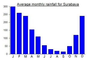
Local Average Monthly Rainfall (mm):
Location
Click on the blue arrow ![]() (top right) to see your current location on the map
(top right) to see your current location on the map
Halo , Mr Dan Quinn…Thank you for visiting Bawean Island, I am Bung Heri from Bawean Island a Local Cave Guide…Maybe you interest exploring again bawean island especially our Caves.
warm regards
Bung Heri
I had long wanted to visit this island out in the Java Sea north of Surabaya. Essentially you need about 3 days for it – 2 for getting there and back and 1 for the actual hike. It might be worth staying an extra day and visiting some of the beaches and some other minor hikes, though you can fit in a quick trip somewhere on the day you arrive, assuming your ferry gets in at the usual 12.30pm. Sangkapura definitely ranks as one the friendliest little towns in Indonesia. The folk are unexpectedly worldly too, as many of them have for generations gone to Singapore and Malaysia in search of work. The island has been known as ‘the island of women’ for that reason – there are more women here than men because many men seek their fortunes elsewhere. Conservation is important here and the island is pleasantly undeveloped. Several recent research projects have been funded by international organizations, including the Bawean Endemik Konservasi Initiatif (BEKI).
We started out very early at 2am in Malang, got a ‘travel’ to Surabaya, had breakfast, then took a taxi out to Gresik (Rp125,000 including toll fees and pier entrance). The pier itself is a typical grubby place, but the passenger terminal is fine and the folk are very friendly. One chap showed us his old Panamanian passport, having presumably worked out there for some years. It was Nyepi (a public holiday) and so the boat was full – you could probably get a ticket on the day if you turn up before 8am but if possible try to reserve in advance. The ticket office opened at 7am. The standard executive class seats were absolutely fine, even with the dangdut (!), but there are also some VIP tickets for a bit more. We boarded at 0835 and left promptly at 0905. On the boat there is a map of the island with a view places of interest including hot springs, the endemic deer site, Tanjung Ga’an (or Ge’eng) and probably most famous of all Danau Kastoba – a pleasant lake which is of spiritual significance to the Baweanese.
The crossing was very pleasant on a calm sea and other than Karang Jamuang Anchorage there is not a lot to note until you arrive 3 and a half hours later in Sangkapura. There are two piers – one for the fast ferry and one closer to the town centre and alun-alun for the slow economy class boats and Pelnis. The hotels are inbetween the two.
Ojeks are not as common on Bawean as eslewhere but you will probably find a guide with a motorbike rather easily. We found the very pleasant Rafa (0812 3320 1487) who, along with his friend, took us to Tanjung Ga’an, a small cape with jagged rocks next to a tiny bay suitable for swimming. Rafa is definitely recommended as a friendly and knowledgeable guide for all of the tourist sites on Bawean. The name ‘ga’an’ apparently refers to the rock that looks like coral risen from the ocean. Lots of deep holes here so real care needs to be taken. In roughly the same part of the island is the endemic deer breeding compound. The deer were very nice, but I was more impressed with the huge bats that kept flying past with considerable wingspans. You will even see these in town as we did later that evening at the Rumah Makan Jember by the old fuel station sign.
We had met the head of forest conservation at the deer place, and it was clear we would need to officially ask his permission to climb the mountain, so we arranged to visit the following morning as soon as the office opened.
There was a fair bit of confusion with regard to the exact location and name of the highest point of the island. When you arrive, you will see the centre of the island is very hilly, and many of the hills are of a similar size. From examining Google Maps, and later the Bako map, there are 3 different mountains over 600m in elevation. The highest one was initially thought to be called Gunung Tinggi (‘high mountain’) due to some internet sources but it appears that Gunung Tinggi is actually the name of the third highest mountain and lies closer to Sangkapura (in clear weather you’ll see its pyramid shape from the pier).
There are a couple of other hills that are climbed fairly regularly by tourists – Gunung Gigir and Gunung Sabu. After examining the maps in the conservation office it seemed clear that the mountain were were looking for was called Gunung Besar (‘big mountain’), although their maps had no elevation data on them. Other sources had said Gunung Tinggi is the highest and can be climbed via Dusun Menara, but it seemed now that this referred to a different, lower hill (later confirmed to be around 601m high as opposed the 655m one we were looking for).
So, after a few photos, Hans and Rafa, and Pak Rahim from the office, set out on motorbikes. Pak Rahim stoped to chance into his outdoor gear and then we sped to the trailhead and got quickly started. The going was pretty easy until it became clear we needed to take a left away from the trail and head up the side of Gunung Besar. This meant a good hour of scrambling up muddy, steep terrain covered in spiny plants and branches that often gave way and collapsed! Long sleeves and trousers are definitely recommended to avoid excessive scratches.
I had been calling out to everyone else when we reached 200m above sea level, 300, 400 and so on. It was great to finally shout ‘600m’ as we circled round a minor 600m high peak at the southern end of the summit ridge. When Pak Rahim expressed his keenness to continue to the higher top we could see a few hundred metres away, I was delighted. Not sure about some of the others though! Of course, where we reached this next top, we could see it was not the highest point either, and that the ridge narrowed and got higher still further north. Between the trees and tall vegetation, there were some grand views of lower hills and to the hazy western coastline.
Finally we got to what felt like the summit, and indeed some previous hikers must have thought so too as there was an old, now rotting, piece of material tied to a couple of trees at the highest point. My GPS said 660 – even higher than the 655 published figure. We’d done it!
As the others were eating snacks and taking photos (and even videos), I noticed another further top to the north, beyond a col. It looked a good 200 or 300m away, but it is hard to judge distances in forest. I was fairly convinced that it was a little lower than where we stood, so I didn’t mention it and just forgot about it. Upon looking at my waypoints in Google Earth, it looked like this northern top might be even higher, though the elevation figure on Google was just 627m or thereabouts (a typical underestimation and based on satellitle data captured just every 50m or so, therefore not showing enough detail to be sure about the exact highest point). From some angles, the mountain did appear to have its highest point at the far northern end of the ridge, but from others it didn’t. It is always tough to tell when you have a complex topography under forest cover.
Anyway, being a mad bagger, this issue was like a fly buzzing around my brain so I decided to visit the Bakosurtanal office in Cibinong (between Jakarta and Bogor, and just 3km or 15/20,000 rupiah ojek ride from the Cibinong station on the Nambo railway line) to get the relevant 1:25,000 map to try to clear things up. As it turned out, the Bako map was inconclusive although it does show a lower northern top with an elevation of over 600m, which may have been the top I was looking at from the 660m GPS reading ‘summit’. But the only spot height the Bako map gives is 638m (still the highest on the island) further south along the ridge that we had already traversed. I reckon Bako is wrong in this instance and the true high point is around 655m (as previously published by other sources) and probably the summit we visited (but possibly the more northern top another 200m or so further north). Anyway, I’m counting it as bagged until proven wrong with decent data.
When we got back down after the hike we went round for a quick visit to Danau Kastoba, a lake regarding as sacred by the Baweanese. It is an easy 10 minute hike from the nearest village and is well-marked. After Gunung Besar, it was a perhaps inevitable disappointment, but most of us wanted to get back, bathe and change our wet footwear after 5 hours up in the mountains.
After another evening at Rumah Makan Jember and enjoying the bats that flew past we sorted out transport to the airport for the following morning. On an island that finding ojeks is not so easy it’s best to arrange in advance. We paid Rp300,000 for the 1 hour car journey but without trying too hard so you could probably sort it out for 250,000 or less, especially if the driver is expecting passengers from the incoming flight from Juanda, Surabaya.
Gunung Besar may not be the biggest or most famous mountain in Indonesia, but I cannot recommend Bawean highly enough. It is a great place to visit for a few days and given the transport options it is not as inaccessible as it looks on maps! Give it a try!