Facts
- Elevation: 1,682 m (5,518 ft)
- Prominence: 1,265 m
- Ribu category:
 Kurang Tinggi
 - Province:
 Lampung
 - Coordinates: -5.5133, 105.0952
- Rating:
- World Ribus ID: 69122
Photos
Bagging It!
The large, forested Pesawaran – Ratai mountain range lies to the southwest of Bandar Lampung. Despite being fairly accessible (under 2 hours from Bandar Lampung and easily possible as a day hike) very, very few hikers come this way and so it is a very wild area – there is no litter and you will almost certainly hear the whooping of siamangs and the grunting of ‘babi hutan’ (wild pigs) on your climb. Local student hikers seem to prefer Rajabasa and Tanggamus which is strange because there are actually some superb views from the higher ridges of the Pesawaran – Ratai range. Gunung Bagging visited in October 2011 and this was the first trip to the top since 2007.
Given how infrequently it is climbed you will need to enlist the help of local villagers who can guide you to the top of Ratai (the highest peak in the range), armed with machetes to re-open the trail. Although strong hikers can reach the top in just over 3 hours, it’s definitely not a hike for beginners – the middle section of the trail is basically clambering up steep slopes of dense forest rather than following a ‘trail’!
There are actually 3 peaks with an elevation of over 1,600m and the highest peak Ratai (1,682m) is just twenty metres higher than Pesawaran (1,662m according to US military maps and also the rather lacking-in-detail Bakosurtanal map which labels Ratai as Rantai). They are probably both worth climbing in their own right but not only is Ratai the highest but it is also the most accessible. The third highest peak is Ratai’s southwestern top and looks very dense indeed!
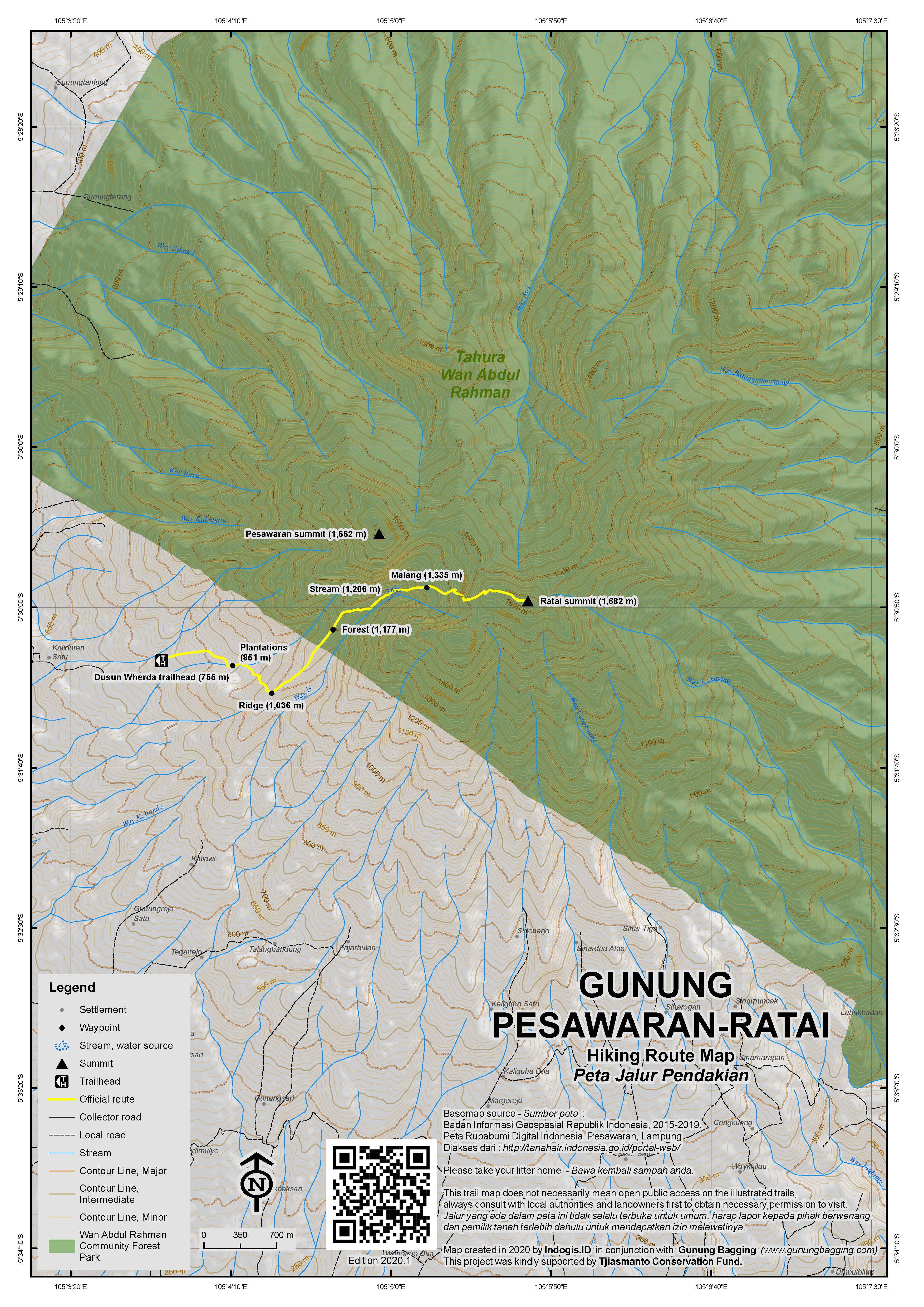
There is a trail from the south of the range near Padang Cermin but this takes longer to reach from Bandar Lampung and access to the summit may be very difficult. The best route starts from the west at the village of Dusun Wherda, Sinar Harapan near Kedondong. You will probably have to ask for directions a few times after Kedondong market and we recommend you take a GPS with you and download our GPS tracks for this hike so you can find the starting point at Dusun Wherda (755m) which is a rather obscure hill village.
Local people in Dusun Wherda refer to the mountain area as ‘Gunung Malang’ but they will understand you if you say you want to get to the ‘tugu’ (monument) as Ratai is crowned with a cement trig pillar from the Dutch era. Locals may also tell you about some of the myths of the area – it is said that there is an area called Gunung Biru somewhere in the vast mountain range on which is a pool of water or stream made of seven colours. The village is in the middle of a huge area of coffee and cocoa plantations and the lower part of the trail leads up through them. Before you leave the village behind you, call in at the RT’s house (811m, home of the man who is the neighbourhood chief) to let him know where you’re going.
From the cocoa plantations (851m) there are some stunning views north west to the almost perfect pyramid of Tanggamus. Above the cocoa plantation and beyond the final hut (932m) the trail follows a ridge (1,036m) which looks like it might continue straight up to the summit of Pesawaran, which is the peak ahead of you on the left. According to local people, however, the trail is a dead end and the terrain is dangerously steep. Indeed, what looks like a pleasant saddle connecting Pesawaran and Ratai looks a lot steeper in reality! From certain angles you can see near vertical cliffs on the visible side of Pesawaran. Therefore, climbing both in one trip may be impossible without making a new trail and, if you wish to do so, it may be better to climb Pesawaran on a separate trail from Dusun Wherda village.
To reach Ratai, there is a smaller, muddy trail to the right (at 1,194m) which drops down to a stream (1,206m). From this point the trail is surrounded by nettles which can cause minor blisters so it would be a good idea to wear gloves. After following and then crossing the tiny stream the trail is very steep and ill-defined. You will need to use both of your hands and take extra care that you don’t slip on the muddy slopes. There are also lots of spiny vines around (‘duri’) to watch out for. This upland forest area is what local people call ‘Gunung Malang’ (1,335m) but there is no peak here – you’re still on the slopes of Gunung Ratai.
As you make progress climbing up onto the shoulder of Ratai the views begin to open out and you will see another peak to the right. This is the third highest in the range – approximately 1,640m elevation. When you finally reach what feels like the top, you are in fact just on the start of the narrow summit ridge (from 1,640m) to Ratai. If you peer over the edge on the left there are some amazing views to the valleys northeast and towards Gunung Betung, a 1,240m high mountain between Pesawaran-Ratai and the city of Bandar Lampung. There is an old overgrown trail along the summit ridge but you will still need to use a machete to clear it a little bit. As you get higher, you can look back to the bushy peak of Pesawaran, the near-perfect pyramid of Tanggamus and to the right to the third peak of the range and the coastline of Lampung. You may even see one or two of the small islands out to sea. Finally you will reach the true summit which is marked with a cement pillar with ‘Sec. Triang 112’ engraved on it.
It’s a fabulous, peaceful area where you are almost certain not to meet any other hikers. However, while at the top, there is the possibility that you may hear what sounds like gunfire in the near distance. This is because the other side of Ratai is the beginning of an Indonesian Army training area. This is one reason we were initially unsure whether Pesawaran or Ratai was higher – because the Bakosurtanal map of the area is blank (i.e. secret) near the Ratai peak.
According to US Army maps from 1954, the peak of Pesawaran also has a summit trig pillar. If anyone has been to it please do get in touch with information on the route you took.
After enjoying the views from a truly undiscovered mountaintop, return the same way in under 3 hours.
Bagging information by Daniel Quinn (October 2011).
Trail Map

For a high quality PDF version of this and other trail maps, please download from our Trail Maps page.
Practicalities
- Getting there: It takes 1.5 to 2 hours to reach from Bandar Lampung. Follow the main road towards Kota Agung and take a left turn at Gedong Tataan towards Kedondong.
- Guides and GPS Tracks: Want a PDF version for your phone? Looking for a guide? Need GPS tracks and waypoints? Gunung Pesawaran information pack can be downloaded here.
- Permits: Not required but do call in to speak to the village RT before hiking.
- Water sources: Usually available at the stream you cross at approx 1,150m.
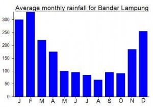
Local Average Monthly Rainfall (mm):

Location
Click on the blue arrow ![]() (top right) to see your current location on the map
(top right) to see your current location on the map
Origins and Meaning
Possibly from ‘pesawahan’ which means paddies. Pesawaran is also the name of this region of Lampung.


 (6 votes) Add your rating
I must confess I wasn’t really looking forward to this one. It looks bushy on Google Earth and there is no tradition of hikers climbing here – no local Mapala (student nature lovers) groups have been here – probably simply because they don’t know about it! Thankfully, excellent local hiker Heri had done some research to find out what he could about the mountain range – without this help it would have been a lot more difficult to sort out. Heri spoke to the locals in advance so they knew we were to arrive. The plan was to get up this mountain before the start of the rainy season. After a long dry period, it started raining in Lampung at 6pm on Friday night and was still raining when Heri met me at my hotel at 6am Saturday morning. On his motorbike we negotiated the huge puddles on the roads and made our way west to the foot of the mountain. We were soaking wet before we even set off!
Due to all the rain we couldn’t actually get the bike up to Dusun Wherda. The last section was just steep, slippery mud. We had to leave it at the house on the corner at the turning for the village and walk up for 20 minutes. The local chaps Heri had met before weren’t very happy about the weather but after countless cigarettes and tea we finally set off up the track. We called in at the RT’s house – he’s a very amusing chap, originally from the eastern part of Central Java. He spends much of his time making wayang kulit puppets.
The plan originally was to reach both Pesawaran and Ratai, but the local chaps lead us up to what they call ‘Gunung Malang’ which is more like the lower slopes between the two peaks rather than a separate mountain. However, as we got higher and higher it became pretty clear that Ratai (where we were headed) was slightly higher than Pesawaran (later confirmed with US map data) and that a crossing between the two might not be possible in a single day.
Because of how infrequently people come here, there are plenty of birds to be seen and siamangs to be heard. There are a lot of wild pigs living here and whereas normally they are very cautious and run a mile whenever a human is anywhere near, we actually almost saw one….. it must have been utterly bewildered to see humans.
At the top of Ratai my GPS gave various readings ranging from 1,680 to 1,720. By this time the weather had improved considerably and there were marvellous views to the Lampung coastline and the surrounding forests. All in all, a very pleasant outing – much better than anticipated.
Thanks Heri! I look forward to our next Lampung hike – either Tebak or Pesagi….
Sadly I had to cancel the trip to Pesawaran/Ratai this past weekend. Not only was I feeling ill on Friday night but also the guide, Heri, seemed unconfident that we would be able to reach both peaks in order to ascertain which is the higher of the two. Apparently getting to Ratai (the more southerly one) is straightforward enough but the trail along the ridge between Ratai and the more northerly Pesawaran peak is pretty overgrown. Lampung has had near-continuous rain for the last few days (perhaps an unusually late end to the rainy season this year) so we decided to postpone this one until later in the dry season so that Heri can go back there and make sure we can hike between the two peaks. Currently stuck on a total of 37 Ribus – so hopefully a total of 50 by the end of the year is still just about viable!