
Facts
- Elevation: 2,230 m (7,316 ft)
- Prominence: 1,373 m
- Ribu category:
 Tinggi Sedang
 - Province:
 Lampung
 - Coordinates: -4.9234, 104.1465
- Rating:


 (5 votes) Add your rating
 Loading...
 - World Ribus ID: 69099
Photos


Bagging It!
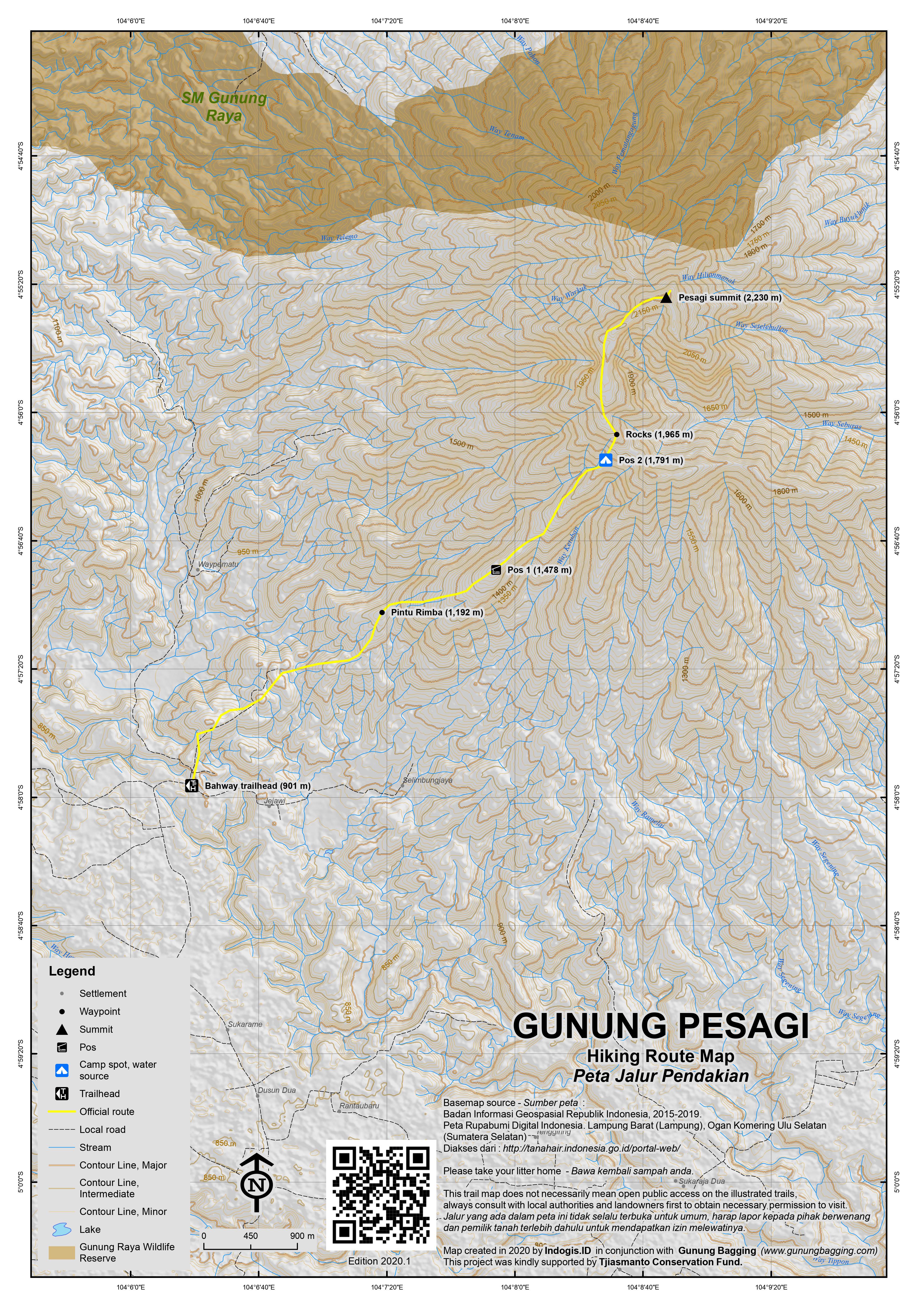
This mountain is the highest in Lampung and offers some of the most challenging yet rewarding hiking in the province. Unlike most peaks in this area there are actually some wonderful open views on the higher slopes of the mountain and both flora and fauna remain relatively undisturbed. Lying just under an hour’s drive from Danau Ranau it makes a great long weekend trip from either Palembang or Bandar Lampung.
The two most popular routes to the top are from Pekon (‘kampung’) Hujung and Pekon Bahway. Both require between 5 and 6 hours for fit hikers and a little less for the descent. The Bahway route starts, unsurprisingly in Bahway which is well sign-posted off the main road between Liwa and Kota Bumi just ten minutes outside Liwa. The road to Bahway is bumpy but most vehicles will have no problems and you should be there in about 15-20 minutes from the main road. A unmarked junction (left turn) is where the hike starts and finding some friendly local people to guide you to the top should be no problem at all. It is essential because it is easy to get lost near the beginning. Also, this is tiger country so it is best to be in a group of 3 or more.
From Bahway (901m), the trail initially leads up and down past a couple of small, old pavillions and through pleasant coffee plantations. After approximately one hour you will reach the entrance to the forest (1,192m) and a couple of nice rocks to sit on and admire the view. The trail for the first five minutes in the forest is somewhat overgrown but it soon becomes much clearer. Be warned that there are leeches here so make sure you check your boots every five minutes or so. The trail climbs steadily for an hour or so after which you should find a flat area (1,478m) clearly sometimes used for camping. This is Pos 1.
After another hour and a half of hiking up through the forest is a steep section where you will need to use both your hands in order to clamber up to a second flat area used by hikers (1,791m) which offers some excellent views into the valleys. This is Pos 2. Chances are you will also hear the call of the siamangs. From this point, the hike is magnificent and you may find orchids and pitcher plants if you are lucky. No longer are you in danger of being sucked by leeches as the forest gives way to different types of bush, plants and small trees. Note that a little trail down to the left of the path leads to a water source and is the last reliable one. It becomes clear at this point why the mountain is called ‘square mountain’ or ‘mountain of four corners’ – there are lesser tops both left and right of the main peak which appear to be at right angles.
The trail climbs steeply up a narrow ridge (be careful here) to another cluster of flat rocks (1,965m) ideal for resting on. This little section actually offers perhaps the finest views on the entire hike. Indeed, you can see the lovely shape of Gunung Seminung, towering above Danau Ranau. The terrain becomes somewhat tougher from this point to the summit as fallen, slippery tree trunks block the path. It is difficult hiking for perhaps an hour as you negotiate each and every tree, climbing under or over as appropriate.
Finally your determination pays off as you reach the summit area. The first building you will see on the Bahway route is the little mosque. Then a few more simple shacks come into views. You may even hear the sound of hens and other animals! A large poster of a local politician adorns the branches of a tree. This is because for the last eight years, on and off, a local man named Pak Somad has called the summit of Pesagi his home. He is a very friendly and eccentric fellow and will undoubtedly be pleased to chat with you!
The summit is also crowned with a large cement pillar with various hikers’ graffiti on it. Two additional trails lead down from the summit. To the left is an infrequently used route about which there is not much information. On the right is the trail to Pekon Hujung and sometimes a source of water can be found just a couple of minutes below the peak. It is said that there are seven small wells near the peak that sometimes emit a fragrance similar to perfume. Alas, on our visit we were not able to obtain any water. The views from the very top are actually a little more limited because of the height of the trees, but you should be able to see Gunung Tebak, sometimes called ‘Tangkit Tebak’ in the distance to the east.
After bidding farewell to the fascinating Pak Somad and his chickens you can either descend the same way to Bahway (in under 4 hours) or alternatively descend to Hujung and take an ojek back round to Bahway.
Bagging information by Dan Quinn (October 2012)
Trail Map
For a high quality PDF version of this and other trail maps, please download from our Trail Maps page.
Practicalities
- Getting there: There are regular buses from Bandar Lampung (Rajabasa terminal) to Liwa. There is even a bus all the way from Jakarta. There are also plenty of buses from Palembang via Batu Raja. If driving, if can take between 4 to 6 hours to reach Liwa from both Palembang and Bandar Lampung.
- Guides and GPS Tracks: Want a PDF version for your phone? Looking for a guide? Need GPS tracks and waypoints? Gunung Pesagi information pack can be downloaded here.
- Trip planning assistance: Would you like Gunung Bagging to personally help you in arranging your whole trip? Please contact us here.
- Permits: Not required but take a photocopy of your passport photo page just incase.
- Water sources: Available just off the main path at Pos 2 on the Bahway route and sometimes available just below the summit on the Hujung route.
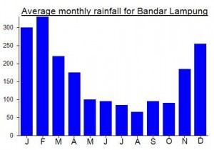
Local Average Monthly Rainfall (mm):
Location
Click on the blue arrow ![]() (top right) to see your current location on the map
(top right) to see your current location on the map
Origins and Meaning
Possibly ‘four corners’ or ‘square’. So, “Square Mountain” might be a reasonable translation. See also Peuet Sague in Aceh.
Hiked up Gunung Pesagi from Bahway base camp. Pak Selamat at the Basecamp arranged Motorbikes to take us for a hairy ride to the Trailhead…50,000 per bike
And 15,000 rph each entrance fee
Car parking 50,000
No need for a guide
The climb was through dense shaded rainforest with many rope sections we reached POS 1 after an hour Pos 2 After 2 hour 15 min and the summit at Mid day after 3 hours and 45 mins
There were a few shacks and a basic Mosque and a few locals hanging about but there was thick fog so no view
We started down along the long ridge of the mountain…the last section was very slippery due to recent rain…and climbing down the ropes was tricky…made it back to basecamp in 4 hours
Enjoyable and fairly challenging day hike…watch out for Leeches and at Pos 2 …Tigers!
How much the scale of peta ? Skala petanya berapa?
This from Mykhailo concerning his recent ascent of Pesagi….
“Pak Somad is still there, but when I met him its looked that he is much complaining about his life, and when I spend a night in his hut, seemed he always in a semi-starved state and often hinted whether I brought something delicious in my pack. Apperently, his life is depends on climbres donation, so after spending so long time in this inhospitable place, he addmited that he actually planning to leave after “puasa”.
After an afternoon of slumber at Wisma Pusri on the shores of Danau Ranau, me and Heri set off for Bahway near Liwa. He had found us a couple of local village lads who would be delighted to take us up to the top of Pesagi for dawn. When we arrived I was immediately filled with confidence on meeting the first of the local chaps. He was obviously a tough farm boy who knew what he was talking about and was eager to head off up into the hills at midnight! A very friendly bunch of villagers.
The first section of the trail is rather slippery and muddy but one of the advantages to climbing at night is that you don’t mind it too much when you can’t really see it properly! Beyond the coffee plantations we rested on a couple of fabulous rocks ideal for a quick break before entering the forest.
I was lucky to avoid all but one leech. You definitely need to watch out for them here (unless you don’t mind having itchy shins for days afterwards!) By 1,750m the trail gets pretty steep and actually quite demanding, but it is obvious even in the dark that there are open views to both left and right of the ridge and it feels as if you are nearing the summit. In actual fact the true peak remains quite a distance away and the final hour is something of a slog as slimy logs must be clambered over or crawled beneath.
Our timing was perfect and we reached the summit at about the same time we no longer needed our torches. After the lack of litter and wild feel of the trail I was shocked to find a collection of basic shacks plus a small mosque at the summit. Even more shocked were the group of locals who had climbed from Pekon Hujung and had certainly not expected to meet an Englishman on the mountain. Indeed, locals reckon I was the first foreigner to climb it.
We took a few photos by the summit pillar and out from one of the basic buildings came a giggling chap. Ho, ho, ho, hahaha!!!! It was Pak Somad, who was astounded to see a foreigner quite literally in his back yard. It turned out that he had lived at the peak, on and off, for 8 years! Quite remarkable. Pak Somad, perhaps an apt name! He was exactly the sort of character I wanted to meet for my 50th Ribu. It was perfect.
In the distance to the east we could make out a peak that we were trying to identify. According to Google Earth this is Gunung Tebak, which looked pretty impressive in the early morning light.
After a few hugs and much laughter from Pak Somad we set off back down the ridge to enjoy better views of the mountainside itself and to Gunung Seminung. Back down in the coffee plantations we enjoyed some fresh guava (jambu biji), the type that is said to be good for relieving the symptoms of dengue fever and/or malaria, plus a nice big papaya.
Me and Heri were back on the motorbike by lunchtime. He claimed to be up for getting back to Bandar Lampung the same day, pretty hardcore considering we had been up all night climbing Pesagi. I persuaded him to take the coastal route back via Krui and Kota Agung. We witnessed a fabulous storm near Krui when the sky turned a beautiful/ominous grey. The road itself was in great condition (brand new surface) but the rain slowed us down considerably and Heri was shaking so much with cold that we had to stop to warm up at a tiny mountainside warung in the middle of the Bukit Barisan Selatan area home to several tigers.
All in all it took us 9 hours to get back to Bandar Lampung. I had planned to get the DAMRI bus back to Jakarta that night (which would have meant an insane continuous 24hr journey from the summit of Pesagi to Jakarta) but all seats were taken.
The following morning I hopped on the 10am bus, still half-asleep. The driver started slowing down less than an hour into the journey and it was obvious something wasn;t right as he desperately made several phonecalls. It turned out that a huge conflict was occurring between local Lampungese and Balinese settlers near Kalianda. Thousands were involved. There were roadblocks, hundreds of soldiers and military vehicle convoys and locals motobiking around armed with pointy sticks. I’ll admit I was rather worried as when the chaos begins in Indonesia it can spread quickly and somewhat indiscriminately.
Several men gesticulated to the bus driver to pull over to the side of the road. This was probably local blokes trying to exercise their tiny bit of authority made available to them only in a time of such conflict. Good work by the driver who made it through and good work too by the police who were out in such number.
It didn’t stop the deaths of 10 people though, as I later found out when safely home. Luckily it is quite rare to encounter this kind of thing but when you do encounter it you have a J.G.Ballard-esque realisation that the fabric of normal, orderly society can break down oh so easily. What a way to end the weekend.
Thanks to Heri! And finest wishes to Pak Somad! I wonder what number 100 will be….