
Facts
- Elevation: 1,763 m (5,784 ft)
- Prominence: 1,223 m
- Ribu category:
 Kurang Tinggi
 - Region:
 Timor-Leste (East Timor)
 - Coordinates: -8.7233, 126.3225
- Rating:

 (2 votes) Add your rating
 Loading...
 - World Ribus ID: 69134
Photos
")
")
")
")
")
")
")
")
")
")
")
")
")
")
")
")
")
")
")
")
Bagging It!
Gunung Mundo Perdido (1,763 m) offers a lovely one-day trek, although reaching its true summit is probably much more difficult. Mundo Perdido (Portuguese) literately means ‘Lost World’. The name apparently originates from the early Portuguese when they first encountered the mountain covered in mist, like most mountains in Timor Leste during much of the year.
The mountain is little known to trekkers and is rarely visited. Even Lonely Planet makes only brief mention of this mountain. Mundo Perdido is a Protected Area comprising an isolated mountain massif and includes the largest remaining area of closed-canopy tropical montane forest on Timor Island. The upper slopes have been protected from agriculture by their steep, rocky, karst limestone terrain.
The mountain is designated as an ‘Interesting Bird Area’ with some 63 species recorded. It is also considered one of the three most important sites for conservation of orchids in Timor Leste. (For further information: A lost world in Timor-Leste, Mundo Perdido: A profile of its biodiversity and conservation; https://www.researchgate.net/publication/275584630). The best time of the year to climb mountains in Timor Leste is August – October when clouds on the mountains are least. The southern side of Timor receives higher rainfall than the north, and the south-facing mountains attract cloud cover even in the dry season.
Gunung Mundo Perdido lies to the west of Gunung Matebean with spectacular views of Matebean in the distance. For those intent on climbing Matebean, a side trip to Mundo Perdido is highly recommended. Mundo Perdido is reached via the Baucau-Viqueque road, now seriously degraded. Bacau-Ossu about 3 hrs by road.
Accommodation is available just south of Ossu before Loihuno. Guesthouse Loihuno rates itself as an ‘eco-lodge’ ($50 per room). It was full at the time with Australians recalling the resistance of Sparrow Force against the Japanese during WWII (https://en.wikipedia.org/wiki/Sparrow_Force). So we stayed at a nearby guesthouse run by Adriano – simple but quite adequate, small double beds ($25-30 per room per night) with meals available. Most people in Ossu speak some Indonesian. We were able to communicate with most people in Timor Leste in Indonesian learnt during the Indonesian occupation and now from Indonesian TV. Few people outside the main towns speak Portuguese although, we understand, this it is being introduced into schools as the national language (why?). English is also being taught.
Like other mountains in Timor Leste, Mundo Perdido was a guerrilla hideout during the Indonesian occupation. (See also Gunung Matebean regarding the Indonesian occupation.) Adriano, our host, was a guerrilla fighter who spent many years in the mountains with the resistance. Photos of Adriano hang on the walls in the sitting room – as a resistance fighter and being awarded medals by the President. A cave, in a nearby mountain, several kilometres south of Ossu to the east, was one such hideout and is now being developed as a memorial for those killed during the resistance. We were requested to pay various charges to visit this cave, which we were assured was for its development as a tourist site. These fees were quite exorbitant so we declined and made a donation instead.
We did however enter a lower cave ($10 per guide). The climb starts on the only high saddle/divide several kilometres north the township of Ossu (about 950 m). This is the highest point along the road, descending to the north to Bacau and south to Viqueque. Stock up on water and snacks at the village market in Ossu. At this point (about 950 m) are open cow pastures to the west, below Gunung Mundo Perdido. Drive as close to the base of the mountain as possible and begin the trek from here.
A local guide is recommended – ask Adriano to arrange or in nearby village houses at the start of the climb ($20 per guide). The trailhead would be hard to find without a guide. Moreover, be aware that it is easy to become lost on the mountain without a guide in the event of heavy cloud. The trail leads up, on the right-hand side of and hugs, an enormous karst limestone outcrop. The trail itself is up broken rock, through forest, etc. but nothing too difficult. Hint: follow the cow pads up the mountain – the cows always find the easiest route up a mountain! After about 1:30 hrs and at about 1,300 m, the trail emerges onto open cow pastures on steep slopes where Bali cattle and buffalo graze. Look back to the east and you may see an amazing profile of Gunung Matebean in the distance. There are spectacular views towards the south coast. The crest of the cow pastures seemed to be the end of trek (about 1,400 m) at least for our guides.
The true summit of Mundo Perdido lies some distance beyond to the east through dense forest. The peak appears to be a very steep, rugged climb up karst limestone rocks. Upon enquiring about climbing the summit, our guides simply informed, ‘tidak bisa’ (not possible). So we lay in the sun at the highest point of the cow pastures, took in the wonderful views towards the south coast, and began our descent via a different route. This involved a much longer but relatively easy trek down through the cow pastures then through light forest (muddy in places from springs on the mountain), village gardens and back to our transport at the trailhead. The round-trek took some 6-7 hours. At the end of the day, we took a bath in a river with a large pond across the road from Adriano’s villa. A very enjoyable day and highly recommended!
Submitted by: Nicholas Hughes, July 2018
Practicalities
-
- Getting there: Three hours from Dili to Baucau by road. Four hours from Baucau to Ossu by 4WD/bus/truck. If you have a small group and/or sufficient money it is best to hire a 4WD and driver in Dili. Or hire motorbikes.
- Accommodation: There is basic accommodation just south of Ossu (see text). In Bacau, just down from the Pousada Bacau ($70-75) in the old town area, is the bright orange Tato Toti ($35) and a delightful back-packers guest house further down the road ($20-25) overlooking the sea. (Don’t be confused if you Google ‘Bacau’ – there is also a ‘Bacau’ in Romania!)
- Permits: None required. Enquire at your accommodation near Ossu regarding guides or at the village near the trailhead. Be advised that guides may not be willing to climb in the wet season or cloudy weather.
- Water sources: Unknown.
Local Average Monthly Rainfall (mm): 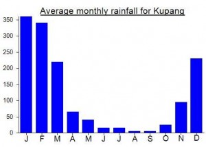
Location
Click on the blue arrow ![]() (top right) to see your current location on the map
(top right) to see your current location on the map
Worth a read here…. https://www.peakbagger.com/climber/ascent.aspx?aid=1782804
“*Since doing this climb I have found out from some Timorese friends that the summit can be accessed with a guide from the village (suco) of Builale to the north. The old colonial 1:50,000 map indicates a survey marker on top – the actual high point labelled as “Monte Uato Suni” (“Monte Mundo Perdido” being the massif). “