
Facts
- Elevation: 1,332 m (4,370 ft)
- Prominence: 1,010 m
- Ribu category:
 Kurang Tinggi
 - Region:
 Papua
Papua - Coordinates: -3.4608, 135.7842
- Rating:
 (Bagged it? Be the first to rate it)
 Loading...
 - World Ribus ID: 80094
Bagging It!
We currently know very little about this peak – please contact us if you can provide any information. It’s a borderline Ribu, with 1317m height from SRTM which would mean a prominence of 995m. SRTM is usually lower by 15-20m than the true height so it is probably just about a Ribu. Naming this peak is difficult – Legare may only refer to the hills further north. The Bako map names Gunung Botak (1,292m) in the area, but this is highly unlikely to be the correct local name.
Practicalities
-
- Getting there: Unknown
- Permits: Unknown
- Water sources: Unknown
Local Average Monthly Rainfall (mm): 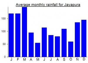
Location
Click on the blue arrow ![]() (top right) to see your current location on the map
(top right) to see your current location on the map