
Facts
- Elevation: 3,265 m (10,712 ft)
- Prominence: 3,118 m
- Ribu category:
 Sangat Tinggi
 - Province:
 Jawa Timur (East Java) and Jawa Tengah (Central Java)
 - Coordinates: -7.6273, 111.1946
- Rating:

 (44 votes) Add your rating
 Loading...
 - Other names: ꦒꦸꦤꦸꦁꦭꦮꦸ
- Eruptions: 1885
- World Ribus ID: 69007
Photos


Bagging It!
This Ribu has two excellent paths to the top from the south, with the two trailheads just 800 metres apart (though in different provinces!) It is perhaps Java’s easiest 3,000m peak, especially since the two most popular paths start at an elevation of 1,900m, and is perhaps the island’s most mystical. It’s a great hike for those new to hiking in Indonesia and the views are fabulous. Although the volcano hasn’t erupted since 1885, you will be able to smell sulphur if ascending from the south, as there is considerable fumarole activity at the crater known as Kawah Candradimuka (approx. elevation 2,550m but not ordinarily accessible).
The closest town to the starting point is Tawangmangu, about an hour’s bus ride from the city of Solo. Tawangmangu has plenty of accommodation which is probably worth making use of so that you can get an early start the next morning. Many of the roadside warungs at the trailhead will also let trekkers bed down for the night for a modest fee. A little further east is the little town of Sarangan which has a lake and has been a popular retreat at weekends since Dutch colonial days. In clear weather, Gunung Lawu can be seen from the lake.
The trailhead for the “main” route is about 10 kilometres east of Tawangmangu at Cemoro Sewu, just over the East Java border. You are requested to register here. Gunung Lawu is a very popular hike with Indonesian students and there is even a warung (shop) and well (for holy water), Sendang Derajad/Drajat, near the top. It is possible to climb and descend in one day (or to climb through the night, setting out at around 11pm to be sure of reaching the top for sunrise), but unless you are both incredibly fit and in a hurry, you will probably need to camp one night on the mountain.
The mountain lies on the border of Central and East Java and sunsets over Merapi and Merbabu are nothing less than spectacular. Apparently, the last king of Majapahit Empire in the 15th century, King Brawijaya V, retreated here – there is a prominent cave, Sumur Jolotundo, on the way up from Cemoro Sewu – and accordingly the mountain has significant traditional and spiritual significance for the Javanese. Many Indonesian presidents have visited the mountaintop and the mystical Hindu roots are obvious. Hikers are warned to avoid green clothing, for the same reason those who visit Parangtritis beach near Yogyakarta are similarly advised.
The area beneath the summit is home to 4 friendly families (in 2017), some of whom only descend a handful of times per year. They are obviously very resourceful people, and you will see some vegetable cultivation going on (including onions), and even some unusual art – beyond the main warung is a shelter made from glass bottles, cans and other discarded items that otherwise would simply be litter.
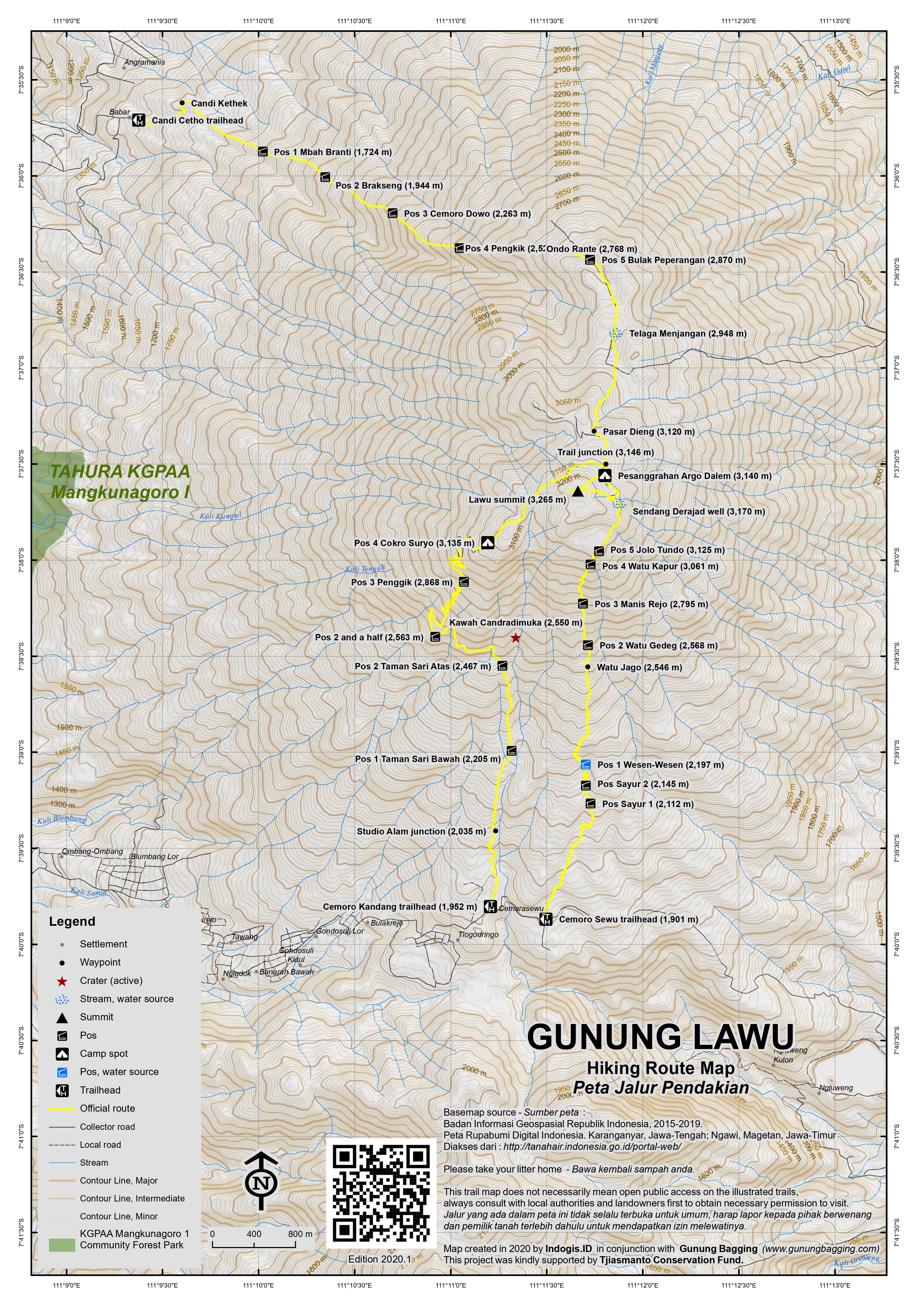
The Cemoro Sewu trail (starting elevation 1,901m) is roughly paved with stones the whole way up, with cut steps and handrails in places. This makes it an attractive route during the wet season, as it does not get slippy. The route is steep, however, and the rocky surface is not the most pleasant to walk on. There are 5 posts (pos) on the way up, and it takes approximately 45 minutes between each: Pos 1 Wesen-Wesen (2,197m) near the spring Sendang Panguripan, Pos 2 Watu Gedeg / Watu Jago (2,568m), Pos 3 Manis Rejo (2,795m), Pos 4 Watu/Batu Kapur (3,061m) and Pos 5 Jolo Tundo (3,125m). Note that there are two other shelters (at 2,112m and 2,145m) before Pos 1, at least one of which is known as Pos Sayur (‘vegetable post’).
The forest is fairly degraded but on the plus side the views from the trail are excellent, especially over to the southern hills on the other side of the main Cemoro road. This range of lower hills is labelled Kukusan on some maps, but the highest is Gunung Jobolarangan (2,312m).
Between Pos 4 and 5 is a large red sign near one of many caves on the higher slopes of the mountain (3,110m). From this point, the views are stunning and the trail flattens out. After Pos 5 you will see a network of smaller paths and mini cliffs with some caves on the left. Shortly after this you will reach the holy well Sendang Derajad (3,170m). A family lives here all year round.
Other basic buildings come into view, but for those who wish to head straight to the summit it is less than 20 minutes on the first of several short trails that lead directly to the highest point which is known as Argo Dumilah. There is a large cement column and spectacular views in all directions. Down to the left is a shallow old crater known as Telaga Kuning (‘yellow lake’) where numerous hikers have written their names using stones. Beyond the summit is a short, stony ridge which is perfect for photos in the late afternoon and sunset.
The best places to camp are in several flat areas just below the cement pillar on the peak or a little lower down near some simple cottages and a warung owned and run by Mbok Yem and where porters usually spend the night. This area is known as Pesanggrahan Argo Dalem (3,140m) and you can even stay in the warung if there is space to lie down (if you arrive late there may not be any room left). The advantage to staying near Argo Dalem is that it is a little warmer than camping right near the top and the sunrise views are just as good as from the summit as you are facing east. And of course you can also get simple meals and snacks here, even during Ramadan.
Do be warned that it gets very cold near the top and unprepared climbers have died on Lawu. Take extra layers of clothing with you. Early morning frost is common!
After admiring the sunrise over the peaks of East Java (look out especially for Arjuno-Welirang, Semeru and Liman), you can descend the same way to Cemoro Sewu in 4 hours or a little more – or better still head down on one of the other two trails. There is an important crossroads just beyond the warung – left (west) towards Cemoro Kandang or – for the more adventurous – straight on (northwest) towards the ancient Hindu-Javanese temples of Candi Cetho and Sukuh.
For the Candi Ceto route, make sure you have a guide who knows the way as it is much less used than the other two routes and is around 16 kilometres in length (allow 6 hours). You may notice at least two ancient female fertility stones – yonis – (one near the trail junction by the warung, and one near the summit). These must surely be linked to the famous lingam and yonis found at the Cetho and Sukuh temples. If you head down this way with an expert guide, you can take an ojek or angkot back round to Tawangmanggu (about 30 minutes).
From the trailhead, the Candi Cetho route leads via Candi Kethek, Pos 1 Mbah Branti (1,724m), Pos 2 Brakseng (1,944m), Pos 3 Cemoro Dowo (2,263m), Pos 4 Pengkik (2,525m), Ondo Rante (2,768m), Pos 5 Bulak Peperangan (2,870m) and the lake known as Telaga Menjangan (2,948m). Beyond this, the trail leads onto the summit plateau via Pasar Dieng (3,120m) and meets the other trails near the top shortly after.
A much more popular and straightforward option is to do a circuit by heading back down the Cemoro Kandang trail (about 4 or 4.5 hours down). From the junction near the warung, turn left and follow the trail as it skirts round the summit and begins to offer views west to Merbabu and Merapi (and sometimes Sumbing and Sindoro beyond). The trail is a little more overgrown and slippery than the Cemoro Sewu route but the views are possibly even better. The following is a description of the Cemoro Kandang route from the starting point at the base.
The second most popular route starts at Cemoro Kandang (starting elevation roughly 1,952m), a short stroll west along the road from Cemoro Sewu (allow just 15 minutes from one to the other), just across the bridge that marks the provincial border. There is also an entry post here where you are required to register.
The Cemoro Kandang route is longer than the Cemoro Sewu trail, about 11 kilometres as opposed to 7 kilometres. However, it is in many ways a more attractive route – the climb is less steep, thanks to a large number of switchbacks; it passes through pleasant forest at first, and offers more views in its middle sections. It is also a “real” trail, rather than a paved path.
Just as with the Cemoro Sewu route, there are numerous Pos on the way up Cemoro Kandang trail, and from one to the next is around 45 minutes or so for fit hikers. They are: Pos 1 Taman Sari Bawah (‘lower garden’, 2,205m), Pos 2 Taman Sari Atas (‘upper garden’, 2,467m) near Kawah Candradimuka, Pos 2 and a half (2,563m), Pos 3 Penggik (2,868m) and Pos 4 Cokro Suryo (3,135m) which is a superb viewpoint and effectively marks the start of the summit plateau.
From the check-post the trail rises relatively gently through the forest to Post 1, where there is a hut. Note that before Pos 1 is a sign post for a waterfall (Air Terjun Studio Alam, 2,035m). Beyond here conditions remain similar until Post 2, another hut where there is also space to camp. It takes between one and two hours to reach Post 2 from the road. In this first section the trail is very well defined, although it is quite badly eroded in places, and muddy during the wet season.
Beyond Post 2 the trail cuts west, and begins to wind its way around the steep western flank of the mountain, passing another unnumbered post with a shelter. Although the forest is quite thick here there are views through the trees down to Tawangmangu, and, on a clear day, to Solo and Gunung Merapi and Merbabu.
The trail rises up the mountain in a long series of switchbacks, which makes the going easy. Post 3 lies about halfway up the main climb, and beyond here the forest thins and the views become more expansive. The trail is well defined all the way up, though there are places to cut corners on the switchbacks if you’re in a hurry.
The ground levels out at Post 4, which would make an excellent camping spot, and the trail begins to cut around to the northern side of the mountain, remaining level, and actually descending in places. Around 30 minutes from Post 4 a metal sign marks a junction – straight ahead the trail continues to meet the Cemoro Sewu route at Pesanggrahan Argo Dalem, while to the right a short, rough path leads to the summit in around 15 minutes.
Despite being longer, the gentler climbs mean that the Cemoro Kandang route takes about the same time as the main Cemoro Sewu trail. It is possible to reach the summit in about five hours if moving relatively quickly. However, this route is less practical in wet weather and there are occasional landslides (in early 2012 there were a lot of broken branches and fallen trees along the trail, the result of recent high winds, though they did not impede progress).
Given that the two main trailheads are so close together, ascending by one route and descending by the other is an attractive option. This would also allow you to make a decent circuit of the peak.
Lawu’s Southern Hills:
To the south of the main road cutting west-east over the range, the Lawu massif continues for several kilometres with a handful of additional peaks over 2,000 metres high. These were rarely visited and little-known until recently, but in 2019 the most accessible one is an easy hiking route in its own right. Called Gunung / Bukit Mongkrang, it is 2,194m high according to the Bakosurtanal map and there are two separate peaks labelled Puncak Candi 1 and 2 by local hikers. These peaks offer pleasant views from open, grassy summits of Lawu itself. This is nothing more than a half-day outing from the main road over the Lawu massif, though many locals camp up on one of the two tops at weekends.
From the village of Tlogo Dringo, Gondosuli, Tawangmangu, a farm track leads down to the ticket booth and official trailhead (1,769m). From this point on there are several warungs offering shelter and snacks on the clearly-marked and well-used trail. One at an elevation of 1,955 features a stone with an unusual and presumably modern carving. The entire trail offers great views back over north to Gunung Lawu.
It takes less than an hour in total to reach Bukit Candi 1 (2,065m) which is the first and lower of the two tops and camping areas which are about one kilometre apart. To reach the higher peak, follow the trail as it drops down to a little under 2,000m before ascending again up to Bukit Candi 2 (2,194m). It shouldn’t take more than 20-30 minutes to reach one from the other.
In actual fact, the highest peak of the southern hills of Lawu is a further kilometre south beyond both Mongkrang peaks, and labelled Gunung Jokolangan on the map although locally known as Gunung Jobolarangan (2,312m). It is less commonly visited, especially from the northern side, but is more of an adventure than Mongkrang and there are good views towards Lawu from the summit. The starting point is the village of Wonomulyo, Desa Genilangit, to the south-east and it takes about 2-3 hours to reach the top. Although at the time of writing there are no rules to officially allow a traverse from Jobolarangan to Mongkrang or vice versa, at least one local mountain runner does the entire loop every weekend!
The trail from Wonomulyo basecamp (1,475m) leads over a bridge and follows a wide farm track westwards up into the hills. There is a water tank and water source (1,769m) before the track gets narrower and steeper. Soon, a minor ridge is reached (1,829m). A sign here shows an alternative route back down to the village via a waterfall. The trail is fairly flat for the next little section until another water tank and shelter is reached. This is Pos 1 (1,876m).
From Pos 1, the trail changes direction, more or less following the boundary of Central and East Java, heading north towards Jobolarangan. The vegetation changes too, with forest cover. Pos 2 (2,018m) is a very small spot in the forest and is soon followed by Pos 3 (2,125m) which has a wooden seat to sit down for a break. Here the trail divides, with a left continuing straight up to the summit and a right heading via Camp Mbandulan (2,175m) which is a great viewpoint and good camping spot, worth visiting on the descent.
The summit itself is also a good spot for camping, with Gunung Lawu usually visible due north. The summit area includes a summit cairn, a larger ancient cairn which forms a partial wall, and a deep pit which looks like a well. The well is labelled ‘Pertapaan’ – meaning a sacred Hindu spiritual place meant for meditation, so is likely to be very old indeed.
To reach the summit will have taken most hikers no more than about 2 and a half hours. To descend again to the village takes under 2 hours. There are great views eastwards in the early morning towards the Gunung Liman / Wilis range.
Even further south in the Lawu range is a peak labelled Gunung Semilir (2,023m) on the Bakosurtanal map. It appears to have a forested top meaning no open views. It is labelled Gunung Semar on Google Maps but on the Bako map Semar is only 1,543m high and further south. This is even less commonly-visited and is probably best approached from the south at Girimanik where there is a waterfall but it has been hiked on occasion from Wonomulyo.
There are also some more interesting hills directly south of the Wonomulyo valley and east of Gunung Semar / Semilir, most notably Gunung Kukusan, a shapely pyramid-esque peak which is 1,921 metres high according to the Bakosurtanal map and which can be seen from many hotels in the Danau Sarangan area.
In short, from north to south are: Bukit Mongkrang Puncak Candi 1 (2,065m), Mongkrang Puncak Candi 2 / Gunung Mongkrang according to the Bakosurtanal map (2,194m), Gunung Jobolarangan / Jokolangan (2,312m) and finally Gunung Semar / Semilir (2,023m) and the Gunung Kukusan (1,921m) ridge running west-east.
Bagging information by Daniel Quinn and Tim Hannigan (last updated February 2021).
Trail Map
For a high quality PDF version of this and other trail maps, please download from our Trail Maps page.
Practicalities
- Getting there: For domestic flights we recommend Baolau. There are regular flights and train services from Jakarta to Solo (Surakarta). From there, take public transport to Tawangmangu (Rp15,000 on the bus, approximately 90 minutes). Alternatively approach from the east (Madiun – Magetan – Sarangan).
- Guides and GPS Tracks: Want a PDF version for your phone? Looking for a guide? Need GPS tracks and waypoints? Gunung Lawu information pack can be downloaded here.
- Trip planning assistance: Would you like Gunung Bagging to personally help you in arranging your whole trip? Please contact us here.
- Permits: Register at Cemoro Sewu or Cemoro Kandang. Entrance ticket for hikers is Rp15,000 (2017). The Bukit Mongkrang trail ticket costs Rp10,000 per hiker or Rp15,000 if you are camping up there (2021).
- Water sources: Available near the summit – both at the holy well and in bottles at the warung (small shop).
- Accommodation: Try the Booking.com map above or use this link to search for suitable hotels, homestays, resorts and apartments for your trip.
- We recommend Safety Wing as travel insurance for overseas travellers and tourists hiking up to elevations not exceeding 4500 metres.
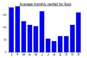
Local Average Monthly Rainfall (mm):
Location
Click on the blue arrow ![]() (top right) to see your current location on the map
(top right) to see your current location on the map
Origins and Meaning
Ashy Mountain. Lawu comes from the Javanese awu meaning “ash”. Probably in the distant past the mountain was called Merawu (mer + awu) “the ashy one” but in the course of time the /r/ changed to an /l/ (see also Gunung Muria) and the initial syllable weakened and disappeared, leaving Lawu. (George Quinn, 2011)
Kath and I climbed Lawu on 22 March 2025 up Cemoro Kandang trail and down the Sewu trail. This was my 3rd tiga ribu in 3 weekends in a row (really enjoying the hiking in Ramadan, and hadn’t hiked over wet season so was in withdrawal!). We stayed in Solo and had a car and driver pick us up at 130am. The drive was a bit quicker than we expected at that time of night, and we were hiking by 2.45am. There was nobody around at the Kandang entrance, all very quiet. The trail up is lovely and very easy route finding – as others have said, a guide is not necessary because the trail is very apparent and also is well taped including with reflective tape.
We walked a solid but not super fast pace, and were on the summit by 630am, so it took a bit under 4 hours in total. I couldn’t get lucky 3 weeks in a row with perfect weather, so the weather at the top was awful. Very windy, light rain and limited visibility with a lot of cloud and mist, so no views to be seen this time. It was a good reminder that the tiga ribus can get proper mountain weather and people need to be prepared – which we were, with plenty of warm and waterproof gear, gps, offline mapping app etc. So was fine, but someone underprepared could have gotten into difficulty up there in those conditions. Needless to say we didn’t linger on the exposed summit – rather, we took a summit photo and immediately focused on getting lower down the mountain and out of the wind.
We came down the Sewu trail, which again is very obvious once you hit the stone path, and is well signed again. We were careful on the descent in the wet, and were at the Sewu basecamp by 930am, so around 3 hours down. We only saw a small handful of other people the whole hike, maybe 6 people and Sewu basecamp seemed very quiet too. I think I might need to return sometime in better weather to try the trail from Candi Cetho and to see the view I missed.
Surely Mt.Lawu is very nice for do a mountain trip
On regularly I am with family and also my colleagues go to Mt.Lawu due to it is very nice to do an exercise and also culinary activities.
Regards
Ony Tjahjono
South Duhail, Doha State of Qatar
https://en.tempo.co/read/1778822/wildfire-engulfs-910-hectares-of-land-at-mount-lawu
How sad that those stalls have been destroyed by the fire with only one left. Hopefully they can rebuild. It’s quite the scene up there with those warungs.
Just like all the other gunungs in Java, Lawu too now has new basecamps springing up on virtually every side.
The latest one is Tambak, to the west, near Candi Sukuh, south of the already well-established Candi Cetho trail.
Given that the basecamp is at around only 1,150m, this is perhaps Central Java’s most energy-sapping trail, with over 2,000 metres of elevation gain required. Obviously harder and more time-consuming that the southern routes that start at around 1,900m. It might be a good one to drop down to though, after coming up from the other side.
Details as follows: Pos 1 Kilban (1,574m), Pos 2 Aruh (1,830m), Pos 3 Cemoro Dowo (2,156m), Pos 4 Telaga Batok (2,430m), Pos 5 Sabana Suket Kuning (2,831m), Sunset Camp (2,975m) and Selo Penangkep (3,135m) where the trail meets the one from Cemoro Kandang. I doubt you could be at the summit in less than 6 hours, more likely 7 or so.
Tambak basecamp contact number: 081393023422.
I remember the first time hiking Lawu back in 2009 and looking over to the hills to the south, still technically part of the Lawu range. Back then there was very little information on these hills or interest in hiking them, but now things are very different with the hugely popular Bukit Mongkrang, and its trailhead just a couple of kilometres from the two main Lawu trailheads.
We got the train to Solo, then Grab up to Mongkrang trailhead. Poor weather as partly expected at this time of year, but quite atmospheric and mot much chance of sunburn. The views over to Lawu are great, but once above 2,000m the clouds moved in and there was nothing to see at all. I left my companion at one of the warungs which are great for a rest, and headed up quickly to Bukit Candi 1. Had it been better weather, or had my companion not been waiting, or had I not already planned to do Jobolarangan the next morning for sunrise, i would have gone on to the higher Mongkrang peak – Candi 2. But with someone waiting, no views, and a second hike planned to the true peak of the southern Lawu hills, I was back down fast.
Quite a few turkeys strolling around near the Mongkrang ticket booth – not a common sight in Java, at least not for me. We were staying in Danau Sarangan, so got ojeks over the border and down into Sarangan village. Be warned that there is often a police check for masks and helmets and ID at the border, so be sensible on what can be quite a dangerous road in wet conditions.
It now costs Rp20,000 per adult to enter the Sarangan lake area – a price that has not deterred locals, with many there at weekends. Remember to keep your ticket in your wallet so if you do a hike the next day you can get back in again without paying a second time!
Mongkrang itself is hidden from view from Sarangan, with a 2,134m high peak lying directly inbetween. This peak has very steep cliffs yet no name on the Bakosurtanal map.
Jobolarangan was the highlight of the weekend. The basecamp lads picked me up at 2am and we were hiking by 3am. Unlike Mongkrang there is a bit of proper forest up here and apparently leeches, though I didn’t ‘meet’ any. It has a real wild, ancient feel like the Wilis range and the stone cairns, wall and well at the top are probably historically significant, like many such mountain ‘monuments’ in East Java that pre-date the Islamic era.
It took a while for the clouds to lift but it was worth waiting for this. Lawu, Merapi and Merbabu all clearly visible, though a little cloudy at the tops, meaning I couldn’t see if Merapi was erupting or not.
The Mbandulan camp site is well worth a quick detour on the way back down – great views to the east.
Another dry and breezy spell in Java right now and… more forest fires. This time Gunung Lawu which is now closed for obvious reasons. It’s unclear if all hikers have been evacuated from the higher slopes yet.
https://en.tempo.co/read/1273339/445-personnel-deployed-to-extinguish-forest-fires-on-mount-lawu
I just got back from a trip up Lawu this morning and I must say that I totally agree with Rod’s comment below. It took me at least an extra hour to get down with the many many “boleh photo mister?”. I guess it is a Saturday so what could you expect.
I left Solo at 1.15am and was at the trail head at 2.30am. I parked my scooter at the Cemoro Sewu basecamp and there wasn’t a sole around. No one to take a ticket at the gate so i just went on up. I didn’t meet any other hikers until the very top. There were a lot of tents though spread out at the different pos’s.
There is just so much rubbish and you can smell the urine at the pos before you even arrive. Its kind of destroying an otherwise beautiful place.
I reached the summit after 2h45m of hiking up. I took it quite easy and just went fast enough to keep warm as it was below 0 on the summit. The grass in sections had frost on it as well.
After the summit I went down to the “highest warung in Indonesia”. It is a very interesting place with a monkey chained up out the front. Apparently he sleeps with Ibu who runs the warung at night, which is truly bizarre. i had a Kopi Susu here and chatted with some hikers who were spending the weekend up there.
I was back at the basecamp around 9am and quite tired after the rocky descent. It requires a lot of mental effort to get down that part.
All in all it was around 5 hours of hiking and 1.5 hours stopping and enjoying the summit and having some kopi at the warung.
A truly unique gunung experience
Just back from Lawu on the weekend (5 May, 2019). Fantastic day. We did the day-hike schedule (i.e., not at summit for sunrise) based out of Solo. We went up to the summit via the Cemoro Kandang trail, and then down via the Cemoro Sewu trail – great loop, totally doable in a day, and highly recommended. We arranged a car/driver for the day, and left our hotel in Solo at 4 am and arrived at the Kandang trailhead just after 5 am. We were hiking by 5:30, just as it was getting light – beautiful time to be hiking. As an aside, no one was in or around the entrance gate (zero activity of any kind), and we simply started hiking up the trail without any interruption, i.e., no one was collecting any fees of any kind.
We were at the summit by 10 am. We then came down the Sewu trail, and were at the gate/road by just a little after 1 pm. We had arranged with our driver to meet us at the Sewu trailhead, so he was there waiting for us. Perfect! Total hiking time was therefore just under 8 hours – although we were moving relatively fast and didn’t hang around much at the top.
Weather was great. We had clear skies on the way up, at the summit, and about half the way down – although, we could see the clouds forming and rising up the slopes. About half way down we entered into cloud/fog, but by then it really didn’t make any difference to us.
All in all, I would recommend this loop/direction. Because the two trailheads (Kandang and Sewu) are so close together, it is easy to arrange a drop-off at one of them, and then a pick-up at the other. Going up the Kandang trail was fantastic. As described in the route description, the Kandang trail is a “real” trail and has lots of switchbacks and good views, making it a nice up track. The real bonus though, was that we had it entirely to ourselves. We literally did not see another person until we were almost at the summit. It is definitely much less used than the Sewu trail. If you want to avoid people, the Kadang trail is the one to take.
Things changed at the summit, where we were greeted by the hordes (hundreds) of gunung-bagging teenagers that are found on gunungs these days. It was a total gong show, complete with the unrelenting “Hello Mister, photo” requests that literally drove us off the summit without really enjoying it. The Sewu trail was very busy with said teenagers, and again provided an unrelenting barrage of Mister-Mister requests. Ah well, all part of the fun!
Tips: a one-day hike up to the summit and back is entirely doable in 8 to 10 hours, provided you are going light and keep moving, and have reasonable fitness to do so. No guide required, the trails are obvious. The Kandang trail is highly recommended, given it is a “real” trail, and will almost certainly have fewer people on it. Going up Kandang, and then down Sewu was great, with the exception of the masses of teenagers on the Sewu side – not sure if that was a special occurrence or not? It was a Sunday, and the day before the start of Ramadan, so that might explain it, or, these were just the usual crowds?
If going up via the Kandang trail, there is a direct summit-trail turn-off to be aware of. The summit area is a bit confusing because of many small trails going to the summit that shoot off the main trail. But you can clearly see the target and where you need to be (i.e., the summit on your right). Going up Kandang trail, after Pos 4, follow the main trail towards the summit. As you are approaching the summit, you will be on a very good distinct trail that is contouring beneath the summit. Keep your eyes open for a trail of sorts, on your right, that goes up the obvious final ridgeline going directly to the summit. If you miss it, which is likely if you are not looking for it, the main trail will simply take you beneath the summit and over to the opposite ridgeline, and then up, which is a tad longer. (see “summit turn-off” waypoint in GPS track)
The day before the start of Ramadhan is a special day. It’s one of the few days in the year there are mass hikes. The night before Independence day Aug 17 and 1 Suro (the first day of the Javanese calendar year in the month of Sura) should also be avoided.
Usually there is almost nobody on weekdays, and a few groups on weekends.
Climbed Lawu Saturday, 19-April-2019 via the Cemero Sewu route (both up and back). The description above is already spot-on, but perhaps a couple tidbits for anyone thinking of doing the climb:
1. No need for a guide: The Cemero Sewu route is not only ridiculously easy to follow owing to its stone path composition for most of the way up, it’s also quite busy. This means getting severely lost is quite unlikely.
2. Can easily be done in a day: We hiked at a very modest pace (60-75 minutes between posts on the way up) and starting at 1am, still finished by ~12 the next day. There are some nice camping spots to be sure, but unfortunately like many well-trodden camping sites in Java, most were a bit dirty.
3. The cold is real: We were extremely lucky to have an unseasonable bout of warm weather on the morning of the climb, but we witnessed a (presumably less-prepared) camper being carried from pos 5 to pos 4, supposedly suffering from hypothermia. Stay safe people.
4. No problem finding a place to stay near the trailhead: For accommodation, we stayed in a cheap guesthouse in Tawangmangu, of which there are many. A bonus of staying in that town is easy access to some tasty pecel and sop at Sop Buntut Bu Ugi
Do you have the GPS coordinates for each of the “Pos” on each trail? We want to take the Cemoro Kandang trail at night but are concerned that the trail is not marked well. Thanks!
Have a look on the GPS tracks page. Should be at least one set of tracks and waypoints. Hope you are planning on doing this before the rainy reason really kicks in (soon).
Had an excellent weekend on Gunung Lawu earier this month – a mountain like many almost deserted at present due to Ramadan. It may be a little bit harder finding guides and porters during the fasting period, but you’ll have the pick of the camping spots at the summits and not have to put up with night-long noise from campers chattering and playing bad music. Indeed, the only music at the top of Lawu other than birdsong was a gamelan recording playing in the famous warung. That’s more like it.
As I hadn’t been to Sarangan before and my co-hikers were coming from Malang, it made sense to get the train to Madiun and approach from the east (breakfast in Sarangan – nice spot for an early morning photo of Lawu above the lake itself).
After a fair bit of serious haggling with porters we got started at Cemoro Sewu and made excellent progress. I noticed a few seemingly familiar plants on the trail… raspberries of some kind (whitebark?), plus plantain similar to the common ones which grow like weeds in the UK but are actually very nutritious (but not so tasty), and bushes/small trees similar to the Pohon Suagi on Papandayan…. Possibly known also as Manis Rejo (also a Pos name on one trail up here) or Vaccinium varingiaefolium.
Lots of birdlife, especially on the Kandang trail on the way back down, and on the summit plateau including very tame birds similar to blackbirds. Also saw a large green pigeon type bird near the summit, struggling to fly away from us so possibly injured.
Cloud meant that the sunset was not quite as good as my first trip back in 2009 which really was spectacular, but very pleasant anyway from that little ridge beyond the summit pillar. Nobody but our group was on the ridge – we had it to ourselves – a real rarity on the 3000ers of Java on a Saturday night in 2017. Didn’t have to leave the tent the following morning to admire the sunrise over Liman, Arjuno and Semeru – a genuinely perfect spot.
Flew back to Jakarta from Solo on the Sunday. This first mean a bus from Tawangmanggu to Solo. I tried the Gojek app in Solo but it seemed like none of them could actually read maps (how difficult is it to find a bald white man in a batik shirt on the outskirts of Solo?) so a regular ojek it was to the airport. Lucky I checked the arrivals and saw my incoming plane was cancelled – just about managed to get put on an earlier one. No thanks to Batik Air for not bothering to email or SMS regarding the cancellation – others who arrived 90min prior to their flight may well have been stuck there for the night!
Hey Dan, We are heading to Lawu this weekend with a good sized gang from Java Lava. Your account has me even more excited
If you’re coming from Jogja, you can contact Bayu, +62 857 4167 1322
He guides people to a couple of mountains in Central Java. He has been to Lawu a couple of times (a lot more so up Merapi and Merbabu), so if you’re touching down in Jogja, you can meet him and he will bring you to Solo and up to Lawu via Candi Cetho. He speaks very good English so you don’t have to worry about that.
Ok thanks for the tip. Do you have contacts for the guide or can I find one in the vicinity of Tawangmanggu?
Hopefully these numbers are still active. Martono at Cemarakandang is 0857 282 366 58 and 0856 421 961 44. Bajing at Cemarasewu is 0815 486 844 10. Ngadino at Candi Ceta is 0853 278 748 82. Martono runs a sate kelinci warung at Cemarakandang. Speak in Bahasa Indonesia or Bahasa Jawa with them.
Dear Handjono,
Big thanks regarding your guide information. Last my mountain climbing in Lawu mountain from Cemoro Sewu with my family on May 2014, condition is on wet weather and we starting on the morning time. And to protect our kids we brought more necessary tools and automaticly problem on our mountain climbing ( on the time I am not have contact person to helped me ).
But it is ok, good experience to training my kids on the nice and safe mountain.
Regards,
ONY TJAHJONO
Doha, State of Qatar
Hi Handjono. Thanks for the numbers. Much appreciated.
The treks of G Lawu are not difficult even under the rain. Make sure you take a raincoat and dry clothes. At the freezing summit you won’t have to erect a tent, there are some good shelters over there. Better to start very early or midnight when the weather is normally better. Candi Ceta route is less obvious half way up, so better trek it with a guide.
Hi, indeed Gunung Lawu is very popular destination for Indonesian hiker, especially for the new one to this activity. I suggest you should try less popular route to climb Lawu, which is via Cetho Temple. The route is very quite and less people dare to try this route. Before you climb, you can also visit ancient Hindu Temple of Cetho, built since 15th century. The scenery is breathtaking and it is said that the route is the gate to the hidden paradise of Lawu. I wrote my past experience when climbing Lawu via Cetho Temple. You can visit my blog, http://inspiring-aya.blogspot.com/2014/11/five-interesting-facts-about-climbing.html
Hi. What’s the weather condition like in the vicinity of Lawu the past few days? It’s pouring here almost everyday in Jogja.
I am planning a hike this weekend but not sure if it’s possible due to wet conditions.
Anyone have any thoughts? Suggestions?
Lawu mountain is a nice mountain that when you arrived in Hargo Dumilah the peak of Lawu mountain on 3265 M above sea level, you can be seen Merapi and Merbabu mountain on west-side, also Welirang, arjuna and Semeru mountain on East-Side. And in Hargo Dalem not only can be seen Brawijaya V the last King of Majapahit retired, you also possible to take break fast with menu ” nasi pecel + telor ceplok ” in mbok YEM the traditional restaurant on Lawu mountain.
Regards.
ONY TJAHJONO
Doha, State of Qatar
Just came back from Lawu in one day, from 5 am to 3 pm.
I think your comment “but unless you are both incredibly fit and in a hurry” is a bit misleading, because it might stop people without gear from trying it as a one-day trip. We are 64 years of age, reasonably trained with some alpine experience, but definitively far from “incredibly fit”, and clearly prefer the one-day solution to staying overnight in the cold and having to carry heavy backpacks.
For all those who like us arrived at 4.30, but the guard where you have to register gone: just go ahead, don’t register. I saw a group of Indonesian guys turn around because they feared there would be problems without the red tape. Anyway, this mountain is free, both for Baraters and locals.
I summited Gunung Lawu 3 weeks ago (Oct. 25-26). Had to stay in Solo for 3 nights for that purpose.
I didn’t want to deal with the hassle of public transportation so I just got a taxi to take me directly to the trail head for a little more than 160,000 IDR (meter) and asked the driver to come pick me up the next day at 10 am. He didn’t know where the trail head was so we had to ask locals for directions after Tawangmanggu.
I originally intended to ascend via Cemoro Sewu and descend via Cemoro Kamang, but since Cemoro Kamang was the first trail head that comes up on the main mountain road from Solo/Tawangmanggu, I got off and registered there. I only found out that it was actually Cemoro Kamang when the caretaker told me. Oh well, I thought, I guess I’m doing this trail. I started at the relatively late hour of 11 am.
Dan’s description above is spot on. The trail from the gate to just after pos 2 is badly eroded so it was prudent to walk above it on the embankment. The appellation of “dormant volcano” is probably a relative term since you’ll hear and smell the sulfur vents near pos 2. The switchbacks Dan mentions above are between pos 2 and pos 4. The views between these two camps are stupendous. I met only one group of three young guys on my way up, otherwise I was completely alone.
The point after pos 4 when the trail meanders around the northern flank of the mountain, and even descending at some points, was also awesome. By this time you’ll see the several peaks surrounding Lawu’s summit. At the junction (summit to the right, warung straight ahead) I decided to go directly to the warung. It was about 5 pm by that time and I wanted to be settled indoors by sundown.
I was the the only climber in Argo Dalem that night. I brought my own sleeping pad and sleeping bag so I was ready for the cold. However, it was a sleepless night because mice were scurrying around me. I left my dinner (bought from the warung lady) uneaten beside me and this attracted the resident rodents. I quickly returned my dinner plate to the kitchen but the mice just won’t go away. I had nightmares of mice nibbling on my ears. Don’t judge me, I hate mice! 🙂
Woke up early at around 430-5 am because of two girls from Singapore knocking on the door. We summited together that morning.
I descended via the Cemoro Sewu trail. In retrospect, given my endurance level and climbing abilities, I picked the right combination of trails (up via Kamang, down via Sewu). It was a straightforward trail on Sewu but it’s extremely steep. The bit between pos 2 and pos 4 was the most challenging I think. I was glad I was doing it in the opposite direction (going down).
It took me about 5.5 hours to climb via Kamang, and around 3.5 hours to descend via Sewu.
I walked on the main mountain road from Sewu back to Kamang, crossing the border of Central and East Java on the bridge. My taxi driver failed to show up but the caretaker at Kamang, Budi, called his friend who drove me back to Solo for 200,000 IDR.
Budi is a font of knowledge for Lawu. He speaks good English. His contact details are:
budilawu@yahoo.com
+62 (815) 7589-9797 or
(853) 2933-5077
i just completed the cemoro sewo route 2 days ago.i couldnt be bothered with the whole bus experience from solo so i just forked out the 200,000 for a taxi to take me to cemoro.as it turned out i got a dud taxi driver that wanted to drop me off at tawamangu even though he had agreed to take me to cemoro.when i said to keep going he demanded a extra 50,000. then he got lost which is no mean feat since theres only one road up there.then when we got to semoro i gave him 300,000 because i had no small notes on me and he wouldnt give me change.
NOTE TO ALL TRAVELLERS. make sure you always have small change on you because it seems that if you dont have the correct amount then it is your fault.i wasnt in the greatest of moods starting the hike. i signed in at the hut and decided that i wouldnt bother looking for a guide.the cobbled road looked decent. normally i would always reccommend you take a guide especially when its your first time.but for this one theres no need.. the path is very defined all the way and you will probably come across other people on the way.i wasnt all that impressed with the walk at the start considering i was wondering why i just didnt ojek it all the way up.but this mountain comes alive when you near 3000 meters. the views are amazingin all directions and the lady in the warung makes the meanest coffee and noodles with egg. fried tahu is good as well. after a feed continue around the bend until you reach a hut that has bedding for free.its not the ritz but it sure beats messing around pitching a tent.and i think because its 100 height meters lower and sheltered it makes a warmer alternative to camping on the summit.the only downside is it can get a bit rowdy in there so you might not catch much sleep.
i didnt get the great views of all the summits but still decent enough.on the way back down i met up with the java lava crew.in hindsight i wished id done the trip with them.after spending a week alone using my 20 word bhasa vocabluary i enjoyed chatting to christian and drew.
so after my 1 week of climbing sindoro ,merapi and lawu my conclusion is that travelling alone sucks.the hiking is great. hanging around inbetween not so great. maybe its a sign im getting to old since i seem to prefer comfort and familiarity over exotic and unpredictable.
inbetween getting ripped off i met some very nice people. just beware of the merapi cowboys.
Hi Chris,
It was great to meet you on the mountain. We had a very cold and rainy night at the summit, but had great views until (almost) sunset. We’ll make sure we keep you updated about our upcoming trips.
The problem with taxi drivers refusing to give change is pretty universal in Indonesia – happens to me every day in Jakarta …
Best regards
Christian
just finished hike from cetho temple route. it really worth to trek with fascinating scenery after pos cemoro lawang. The vegetation quite dense and U will rarelly see garbage along the route. Although this route is not popular as cemoro sewu / lawang, i think this route is the best.
how to get there is easy :
1. from Solo, take bus that leading to tawang mangu, and down at karang pandan terminal
2. take bus to terminal kemuning (from karang pandan)
3. take ojek to cetho temple
If you come from the East Java side you approach Lawu via the attractive lakeside resort of Sarangan. First get to Madiun, which is served by several trains between Jakarta-Malang and Jakarta-Surabaya. From Madiun it’s an hour or so (Rp10000) by bus to Magetan, then 45 minutes (Rp10,000) by minibus to Sarangan, where you can check into one of the many hotels or take the 20-minute ojek ride (Rp20000-Rp50000) up to the “warung village” by the road at Cemoro Sewu or Cemoro Kandang.
I hiked from Cemoro Sewu and came down to Cemoro Kandang.
A 10 p.m. start on the Cemoro Sewu ascent is probably too early for most. Regular hikers will need only 4 to 5 hours to reach the summit by this route.
I took 6 hours, but that’s because I went the wrong way at Pos 5 and spent a fruitless hour exploring a maze of paths on the plateau and cliff area south of the summit.
In the hope that nobody repeats my mistake, here’s a more detailed description of the summit area.
As you reach Pos 5, ascending from Cemoro Sewu, you need to veer right, where the paved track continues around the east flank of the mountain. (Don’t go straight on like I did!) After about ten more minutes, undulating at about 3150m, you will reach the Sendang Drajad warung, with the stone well and a bamboo shack beside it. About 200m after this, where the main trail bends around to the right, you can strike out directly for the summit by keeping straight on up the hillside. It’s better though to stay another few hundred metres on the main track, past a shrine-like gazebo and a wooden cottage belonging to the Kiky stationery company, until you see the Hargo Dalem warung. The best path to the summit, marked with a metal sign, goes up to the left about 50 metres before you reach the warung.
The Hargo Dalem real estate complex, situated at the northeast corner of the mountain, comprises the warung, a shrine fronted by shacks, and a large wooden cottage belonging to the Solo kraton. The Ceto descent begins directly from the northeast corner. For the descent to Cemoro Kandang, keep contouring round to the north side of the mountain. After five minutes you pass another summit path marked by a metal sign and after a further kilometer of flat going, you reach Pos 4 (that’s Cemoro Kandang Pos 4!) and begin descending around the west side of the mountain. My descent took 4 hours.
Sorry Dan. Tamansari Bawah, Tamansari Atas, Penggik and Cakrasurya are the posts along Cemarakandang route. Not Cemarasewu.
Candi Ceta route is definitely worth trekked. Candi Ceta itself is a beautiful temple, also the higher altitude Candi Ketek (Monkey Temple). The savanna near the summit is beautiful and mystical. Also the famous Pasar Setan (Ghost Market) 500 meters before the Hargadalem summit complex.
But be careful with the bees in the dry season. They are the masters of the trek between Pos 2 and Pos 4. The sting is very very very painful. Your own urine would help although it does not totally cure. Make sure you do not get one on your head otherwise you could faint. But strangely the sting makes you stronger afterwards. You would not easily feel tired for several days.
just got back from climbing lawu this morning. went solo and pretty light and fast, started from sarangan about midnight and reached trailhead about 1:30am. summited 5:30 just in time for sunrise.
despite the easy to follow path climbing this mountain at night is pretty spooky but experience was amazingly rewarding. now i need to sleep 🙂
Hi guys,all of the experience in Lawu must be really great, but i realy suggest you all to try the route from Cetho Temple. the atmosphere of the forest still natural and heavy, also you all will through such a vast prairie.
this route is absolutely serve an amazing view, 🙂
wanna some pfoof? just google it, 🙂
I’ve climbed this mountain via cemoro sewu but I Really want to try hike this mount via Cetho Temple route (the true face of mt lawu nature).
Was at the summit of Lawu, staying at the Warung for 2 nights last week. We had wanted to ascent from Cemoro Kandang but had to settle from Cemoro Sewu as we were advised by our guide that of the following rules:-
1. all who climb Lawu must start from Cemoro Sewu in their first climb;
2. no ligh green clothing as it appears to be the colour of the spirits of Lawu;
3. no lamentation of tiredness or that the distance to go is still far way during the climb(? or the spirit would be upset).
There is warung at the summit whereby you can buy food, Aqua water, drinks and also to rent a floor space within the wooden building for the night – it is clean and safe. The warung owner who is a woman has been living continuous at the summit for the past 22 years!!
We came down towards the Candi Ceto temple which lies in central Java and is located at the foot the mountain(end of the hike)in which warungs and road network are in place there.
Very cold at the summit with good views. Took my son along for his first mountain bagging!!
Hi Anthony,
Thanks for sharing your exprience.
Hope you don’t mind some questions that I have…
1. Did you stay at Tawangmanggu before starting the hike ?
2. Where did you hire the guide ? Do you mind sharing his contacts ?
3. You mentioned that you stayed 2 nights at the summit. Did you take food supplies along with and cooked your meals OR you could get food at the warung there.
4. I am guessing that you must have started off from Solo. Did you pre-arrange transport from/to Solo ?
It would help if you can share the expenses incurred at a high level. Planning to climb Gunung Lawu in the next 2-3 months, so I could certainly use that as reference.
Thanks so much.
Cheers
Sam
Hi Sam,
I am really sorry that I missed reading your comment and questions to me. Let’s me try to answer your questions:-
1. We didn’t stay at Tawangmanggu but instead we stay at Sarangan which is a local tourist small town next a a lake. Sarangan is very much nearer to the entrance of Gunung Lawu than Tawangmanggu. There a number of small hotels you could stay in Sarangan.
2. Yes, we did hire guides and porters. I don’t have their contacts but my Indonesian wife does (if you need it, just email to me at anthonytansh@yahoo.com.sg and I will find out from her.
3. We did bring enough food for the whole hike but at the summit (or just before the summit, the warung provides all the meals we needed – foods, kopi, tea, eggs, bottled water.
4 We arranged for our usual driver from Jakarta who picked us at Yogyakarta and then travelled to Solo and then to Sarangan. Our driver has a brother providing transport, etc for tourist and possibly he could be the person you could contact for him to arrange everything for you,i.e transport, guide, porter(if you need).
5. For expenses, we actually spend a lot even though we pay at local level (sort of). Sorry I didn’t really didn’t keep track of it but it would be necessary to spend what i did.
Again, sorry for not being able to answer your questions earlier and especially if you had already gone for your Lawu climb – cold and beautiful. Just got back from hiking, with my wife, Gunung Diak at Pulau Lingga (Riau Islands).
Enjoy your mountains and best wishes.
Cheers
Anthony
hi anthony i just read that you had finished climbing gunung daik in lingga.having lived 7 years in singapore and numerous times flown over this island and seeing the impressive finger looking peak i would love to hear of your experiences there.any info on this area would be valuable as their isnt much out there.
cheers
chris
If you’re kicking around Cemoro Sewu before or after your trek it’s worth hunting down Mbah Harsono – he’s sort of Lawu’s more down-to-earth answer to the late Mbah Maridjan of Merapi, a general fount of mountain knowledge, an expert in the mystical aspects of the peak, with top-notch knowledge of the dozens of sacred places scattered around the slopes, and a pretty good guide too, by all accounts. He’s bagged a good few other gunungs in his time too…
We talked of many mountain matters, and I was pleased to note that like me he’s a beleiver in minimal rest stops when climbing a mountain, and also of the practice of “resting while walking”, slowing the pace until you catch your breath, but not actually stopping…
He’s definitely good for a chat over your post-trek coffee and nasi goreng anyway…
Thanks all for the info. Just did this hike over the long weekend from Cemero Kandang. Apparently it is a longer but less vertically steep hike than Cemero Sewu. From the gate to the summit area it took us about 6.5 hours going at decent pace, stopping not more than 15 minutes at each of the 4 posts – about 1.5 hours between each one – along the way.
We weren’t so lucky with the weather on the top the following morning; clouds from the east and unclear skies deprived us of the awesome views described in previous posts. We saw several peaks to the East but none to the West unfortunately. No matter as I’d love to climb back again on the Sewu route.
One note though: from either the Sewu or Kandang routes you can opt to stay at a warung that is at the summit area! The local nature lover’s group members I was hiking with jokingly called it the ‘tallest warung in Java’ (“warung tertinggi di Java…”) – awesome. Many of the cottages and the warung at the summit area are financed by the royal court of Solo, as the Sultan does a once yearly pilgrimage to the summit for religious ceremonies and brings a big entourage along. So the basic infrastructure is to accommodate these large groups as well as the hiker commuunity. We stayed the night on the large, covered open floor of the warung (Warung Mbok Yem) before walking 10 minutes to the summit the following morning.
All in all Lawu was a great long weekend trip out of Jakarta. Definitely worth it. Hope future hikers have clearer views than we did though!
Paul,
Lawu is open most times providing you hike from one of the Cemoro’s gate (either Cemoro Kandang or Cemoro Sewu) It’s a pilgrim’s mountain, following Javanese spiritual tradition. There are also people living on the summit most times of the year. They’re the ones who provides food and basic accommodation up there.
If you’re planning to enter via Cetho and other less traveled route then there’s a bigger possibility that you won’t be permitted to travel by the locals if the weather is unfriendly.
Hope that helps.
Does anyone know if there are permit regulations for Gunung Lawu. I’m thinking of climbing sometime in February (pending decent weather reports). Will there be potential isues with closed national parks due to the rainy season, a la Gede/Pangrango or Rinjani? Thanks…
Before the hike I had quite a low expection on this mountain, since the owner of one homestay in Solo told me there’s nothing to see there. The guy also told me the hike is a easy one with well mantained stone path all the way to the summit, not requiring a guide. Upon seeing the clear weather the following morning, I decided to try my luck on this 3000m peak.
The starting point Cemoro Sewu couldn’t be reached from Solo directly by public transport. I took a 1.5-hour bus ride to Tawangmangu first, but couldn’t find a cheap way to get to Cemoro Sewu. The only transport I could find was some minibuses, all asking for Rp.50,000, five times the cost from Solo to Tawangmangu! A bit pissed off, I reached Cemoro Sewu at around 9:30am, only to find most of the warungs closed and very few people around. With very limited Bahasa proficiency, I simply gave up the idea of finding a guide. After packing two packs of Nasi Goreng for lunch and dinner, I set off.
The first stretch of the trail was along some jungle and farmlands. There are some nice cole flower plantations along the way, as well as some other vegetable plantations, all added to a scenic gentle ascend. However, the trail started to get steeper after the farmlands ended. I was alone for the first 3 hours of the hike, probably because it was a weekday. Up to this point the trail was not very scenic in terms of mountain views, what I saw most of the time was simply a sea of clouds. With the 15kg backpack and loneliness, it started to get tiring. Then, I met a group of 8 Indonesian hikers. With a few simple greetings in Bahasa and body languages, they friendly invited me to join them. With this group of cheerful hikers, it became more fun and less tiring.
After hitting 3100m, the trail became gentle and unpaved. But the view became very extensive towards the east. However, with thick haze below, no distant peaks could be seen. The are a few cottages, a warung and a drinking water source before the last stretch of the trail. I was stupid enough to carry two packs of cold food with me. The group of Indonesian hiker decided to spend the night the cottages, while I decided to spend the night camping on the summit.
The summit was reached after another 20 minutes’ walk. The cement pillar marking the summit had been rebuilt into much taller one. However, the summit area had pretty little space to set up a tent, and it was VERY windy. A few steps down there is a small cottage and an Indonesian guard who was about to leave. He showed me a bushy and less windy place near the cottage where I set up my tent.
About half an hour before sunset, low clouds began to clear up, allowing me to see Gunung Merapi and Merbabu to the west. At the same time, the huge shadow of the mountain started to stretch to the east. I got busy shooting in all directions with my camera. I was lucky enough to have the sun setting on a cloud free horizon, and saw the mountain shadow stretching infinitely to the pinkish eastern horizon. Western horizon started to show magical colours after sunset, soaking inside the silhouettes of Gunung Merapi and Gunung Merababu. city lights from Solo started to peek through the dissappearing haze, shining like stars. Echoing from up above, four of the major planets, Mercury, Venus, Saturn and Mars lined up in the row above the horizon. The view was beyond heavenly. It will remain in my memory forever. The only regret is probably that I couldn’t share the view with anyone, the group of Indonesian hikers didn’t went up to the summit for sunset.
It was constantly windy on the summit throughout the night. It was already quite bad at my camp site. Couldn’t imagine what it would have been like if I camped on the actual summit. Tired, alone, and cold, it was a real pain to wake up at 4:30 to catch the sunrise. Should’ve brought up some cooking gear to get some hot drinks. However, after all the struggle, the view didn’t let me down. The ground down below as well as the sky above were breathtakingly starry. Numerous East Java peaks, including 3000m peaks Gunung Welirang, Arjuno, and Semeru, could be seen against brigtening eastern horizon. Gunung Welirang was smoking in the distance. Gunung Semeru, however, was quiet. As the sun rised, the shadow of the mountained appeared again on western horizon. Central and West Java peaks such as Gunung Merapi, Merbabu, Sumbing, Sindoro, (Dieng)Prahu, Ungaran, and Slamet could be seen nicely lit up by the golden sunlight. The view at this moment was incredibly extensive, I could see peaks 200km away to the east (Gunung Semeru) as well as the west (Gunung Slamet). SEVEN 3000m peaks excluding Gunung Lawu itself could be seen, including Gunung Slamet, Sumbing, Sindoro, Merbabu, Welirang, Arjuno and Semeru. WOW!
The howling wind and excitment made my hands so shaky, thus blurred out so many of my photos. The new cement pillar on the summit is almost 3 meter tall, I couldn’t place the camera on it for long exposures like what I did on Gunung (Dieng) Prahu. Only at this moment did I realize I haven’t taken any photos of myself, and there were nobody around! Then, thank God, three of the Indonesian hikers came as rescue. We help each other take photos and celebrated such magical moments on the summit.
I was really reluctant to leave the summit, so I stayed for some more time while my Indonesian friends went downhill first. As low clouds started forming to block distant mountains, I gotta pack up and hurry back to Cemoro Sewu by 4pm to catch the bus back to Solo. It was a dry and pleasant descend without worries of slipping. I made it back to Cemoro Sewu in less than 4 hours. I noticed quite a variety of birds on the way down. Bird watchers might want to come here for some bird watch.
This mountain can be amazing on a clear day, offering an uncomparable extensive mountain view. However, if weather condition is not favarouble, it might turn out dissapointing since even the nearest peaks are standing over 50km away. Besides, it might be a crowded hike filled with locals on weekends; if you hate it, try to visit on a weekday if possible. Decent camping gear and wind protective cloths are a must if one decides to camp near the summit. Clear skies to all those visiting this beautiful in future.
Lawu is an amazing hike.The road to the National Park will take you out of Solo and into Tawangmangu which is gorgous tapestry of mountainous jungle and classical Javanese terraced rice fields, no doubt ancient in their own right. Twangmanggu is worth exploration itself.
From Tawangmanggu you go to the park’s entrance at Cemoro Sewu. Once you enter the part you immediately start ascending and steadily gaining altitude. As usual the Volcano is used for farming uintil transforming into its own exotic wonderland.The higher you go the more breathtaking the views; and if you stay overnight.
You will be greeted to an amazing sunrise standing nearly 10,000 feet at POS 3 which is just a bunch of ample flat spots to camp at.
Once you arrive at the summit you will be treated to a vast arrays of volcanic ranges and Stratovolcano “Hall of Famers” such as Semeru,Arjuna,Merapi and Merbabu to name a few. Enjoy. The best part is that the road to Cemero Sewu is world class for Indonesian standards and their are manmade ande natural steps almost all the way to the top. You may also meet some cheerful locals making a spiritual trek to the summit!
Was on Ceto’s route heading up to Lawu on the 13th March 2010. Were making good progress and arrived at Post 3 late in the afternoon only to find a 5 days old corpse. Went back down to report and SAR brought a female corpse down. Apparently there’s foul play suspected so the plan to bury her up on Post 3 was cancelled. Oh well, see you next time Lawu. 🙂
I felt tired when climbing this mountain, because the road is long and far. But you should try it, hehehe..