
Facts
- Elevation: 781 m (2,562 ft)
- Prominence: 781 m
- Peak category:
 Spesial
 - Province:
 Maluku (Moluccas)
 - Island: Nila
- Coordinates: -6.7408, 129.5137
- Rating:
 (Bagged it? Be the first to rate it)
 Loading...
 - Eruptions: 1903, 1932, 1964, 1968
Photos
")
")
Bagging It!
The 5 x 6 km Nila Island in the Banda Sea is comprised of a low-rimmed caldera whose rim is breached at sea level on the south and east and contains a 781-m-high youthful forested cone. Phreatic eruptions from the dominantly andesitic Nila, also known as Laworkawra, have occurred from summit vents and flank fissures in historical time. A 1932 eruption from a fissure that extended from the summit to the SE coast produced heavy ashfall that forced abandonment of Rumadai village (Smithsonian).
Practicalities
-
- Getting there: The Pelni ship Sabuk Nusantara 71 visits these remote islands approximately every two weeks from Ambon.
- Accommodation: Unknown
- Permits: Unknown – take a photocopy of your passport photo page just incase.
- Water sources: Unknown
Local Average Monthly Rainfall (mm): 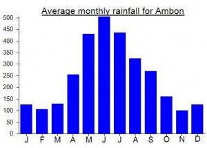
Location
Click on the blue arrow ![]() (top right) to see your current location on the map
(top right) to see your current location on the map