
Facts
- Elevation: 1,308 m (4,291 ft)
- Prominence: 1,101 m
- Ribu category:
 Kurang Tinggi
 - Province:
 Kalimantan Barat (West Kalimantan)
 - Coordinates: -0.2258, 111.2667
- Rating:

 (2 votes) Add your rating
 Loading...
 - World Ribus ID: 69178
Photos

Bagging It!
Gunung Kujau is located to the north of the larger Gunung Saran. Kujau’s elevation is listed as 1,322m on an old US Army Map but local hikers suggest it is more like 1,308m. The Bakosurtanal map actually suggests a much lower 1,166m so some GPS research is required!
Practicalities
-
- Getting there: Unknown
- Accommodation: Sintang is the closest main town and airport.
- Permits: Unknown
- Water sources: Unknown
Local Average Monthly Rainfall (mm): 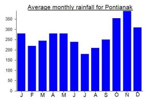
Location
Click on the blue arrow ![]() (top right) to see your current location on the map
(top right) to see your current location on the map