
Facts
- Elevation: 657 m (2,156 ft)
- Prominence: 611 m
- Peak category:
 Spesial
 - Province:
 Nusa Tenggara Timur
 - Island: Flores
- Coordinates: -8.8913, 121.6412
- Rating:


 (15 votes) Add your rating
 Loading...
 - Eruptions: 1671, 1844, 1867-68, 1871, 1888, 1953, 1969
Photos


Bagging It!
When people think of volcano attractions in Flores, they probably think of the Kelimutu lakes and perhaps Gunung Egon near Maumere. But perhaps the most impressive volcano on the island is Iya, a small peak at the end of a short peninsula just 15 minutes south by motorbike from the large town of Ende. Whereas Kelimutu has a carpark near the top and cement walkway to the rim, getting to Iya is a little harder and more dangerous than you would think just looking at it on a map. Additionally, an experienced guide is absolutely essential for this area because despite its low height it is a remote area and more importantly there are some deep gullies which can prove very hazardous when route-finding on the descent.
There is a road leading south from Ende town along the west side of the peninsula which turns into a dirt track before snaking up the hillside slightly. This track is a very messy area – full of rubbish – and is or was the Ende rubbish dump site. There are a few people scattered around the hillside collecting black volcanic rocks in this area too. Don’t be put off by this very disappointing start. From the top of the dirt track at an elevation of about 150m a faint trail leads straight up the steep mountainside. Since the volcano is not very high at all, the temperature and heat from the sun on clear days requires that you set off as early as possible, wear plenty of sun cream and take an unusually large quantity of water with you.
As you follow the vague trail up the mountainside, the view opens out all around you – the flat topped Gunung Meja (‘Table Mountain’) to your left just above Ende town itself, and down to Ende bay and Pulau Ende (Ende island). In about an hour you will be hiking amongst pine trees near the top of the mountain. There are some very deep gullies and ravines halfway up the mountainside but these will not cause you any trouble if you are on the correct ascent route. You should notice a small white hut on the ridge to your left (north) which is presumably a volcanology monitoring hut. After another 30 minutes you will have reached the pine trees covered summit ridge (630m). Make sure you leave something here so that on your return you know exactly where you gained the top of the ridge so you can go back exactly the same way.
From the top of the ridge, the view is superb – suddenly the geography of the mountain becomes clear. Below you is a grassy bowl-shaped depression with more pine trees growing on its sides. This is presumably an old dormant crater. On the other side of the old crater, the grass and trees give way to reddish volcanic sand and it becomes obvious that the sandy ridge on the opposite side of the old crater is the steep cliff edge of the Iya volcano crater which drops dramatically all the way down to the ocean on the other side.
Although it may be tempting to take a right from the top of the first ridge, if you want to bag the true summit (approx 657m), follow the pine tree ridge left for just 5 minutes to reach the highest point of the whole mountain. Views down to the ocean east of the peninsula are excellent. Although you could probably continue down to the old dormant crater and make a full circuit of the mountainside, it is safer and easier to return the same way and follow the ridge round to the sandy active crater cliff edge. It takes just 15 minutes to walk from the true peak to the edge of the active Iya crater.
When you reach the edge of the active crater itself you will be astounded at the sheer scale of it all. From a height of over 600 metres, the volcanic cliff edge drops vertically almost all the way down to seal level. The crater itself is at least a couple of kilometres across and it is certainly as awesome a sight as Raung in East Java or Tambora in Sumbawa. Needless to say, a trip or fall here would lead to certain death so do not venture too close to the crumbling cliff edge. There is also a reasonable amount of volcanic gas on the rim itself so watch out for this. The last major eruption here was in 1969 but it is being closely monitored and it is surely only a matter of time before another big one.
After taking photos of what is one of Indonesia’s most impressive sights, return the same way to the pine trees ridge where you came up and take extra care when descending what can quickly turn into incredibly confusing and dangerous terrain. See the comment below for an account of what happens when you underestimate this ‘little’ volcano. With an experienced guide and plenty of water you should be back down on the mud track in just over one hour and back in Ende soon afterwards.
For those still hungry for more, consider the short hike up Gunung Meja (382m) which takes around one hour to reach the top of from the trailhead (120m) just south of Ende town.
Bagging information by Daniel Quinn.
Trail Map
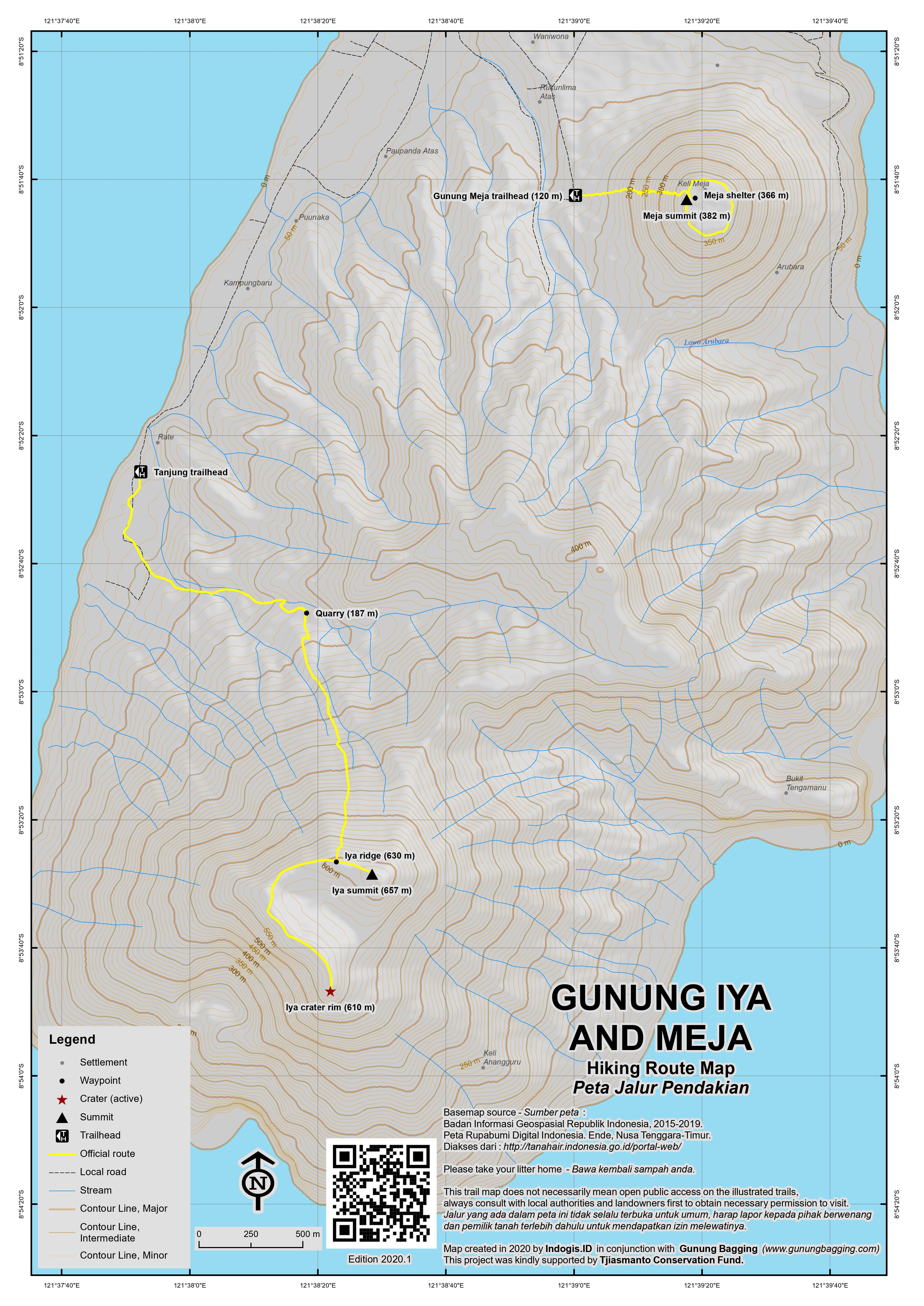
For a high quality PDF version of this and other trail maps, please download from our Trail Maps page.
Practicalities
- Getting there: From Ende, you can easily get an ojek for Rp15,000 to the dirt track at the start of the hike on the western side of the mountain.
- Guides and GPS Tracks: Want a PDF version for your phone? Looking for a guide? Need GPS tracks and waypoints? Gunung Iya information pack can be downloaded here.
- Permits: No need for permits.
- Water sources: There are no sources of water on the hike so take as much as you can carry.
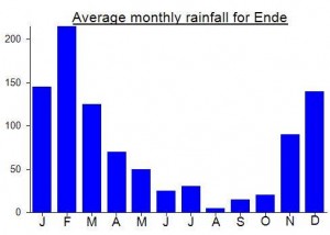
Local Average Monthly Rainfall (mm):
Location
Click on the blue arrow ![]() (top right) to see your current location on the map
(top right) to see your current location on the map
https://vsi.esdm.go.id/press-release/kenaikan-gempa-vulkanik-dalam-gunungapi-iya-7-mei-2025
Mai 2023 – I climb Mont Lya with my wife few days ago (we are late 30s/early 40s, relatively fit). The path is easy to follow but you need a GPS track to find where the track starts at the end of the Quarry/Dump site. A GPS track is also interesting to assess if you are getting close to the active crater if cloudy. The arrival to the active crater is impressive. If cloudy, do not even try to get close, there is no point, and it would not be safe. If clear, it is easier and safer to approach the crater ridge from the Northeast where the ridge is wider, less sharp. To approach, follow the crater ridge (from a distance) on your left when arriving at the end of the vegetation, close to the active crater. Mont Lya is well worth it, small effort for what it is. An immense smoking crater wide open on the sea.
My December Flores trip ended in Ende, where I stayed at the excellent-value LCR Hotel. They put me in touch with a guide, somewhat improbably called Guido, who charged Rp300,000 for the hike up Iya, including the bike ride.
We left the hotel at 04.15, parked at the end of the asphalt road (GPS altitude 13m), and walked the first 30 minutes on the dirt road by flashlight. After passing the dump area, there is a series of turn-offs into sand quarries on the right, some with metal signs saying ‘Hati hati anda memasuki Kawasan rawan bencana 10 Gunung Iya’ (‘Be careful you are entering area prone to disasters 10 Gunung Iya’). At the last quarry (166m), you finally turn right, skirt around the base of the quarry to the right, and should find the path that seems like a dry creek bed, as described in other posts.
We began the grassy lower section in daylight at 05.05. Even after sunrise time, we were sheltered from the sun by the mountain’s eastern ridge until just before we reached the summit ridge (602m) at about 06.20. The lower slopes are very hot when coming down, but there are scattered pine trees potentially offering shade above around 330m, becoming denser the higher you go. After turning left along the summit ridge, it takes ten minutes to reach the top (650m), which is broad and solid, suitable for resting, picnicking or even camping.
The crater area to the southwest however, is more intimidating, with sandy and slippery slopes on the ‘safe’ side of the rim, and a very steep drop-off on the crater side. This seems just the sort of place where an unwary visitor looking for that ultimate selfie could back lethally into the abyss.
After smelling the sulphur and watching ships rounding the headland, we began the descent at 07.20, returned to the quarry at 08.45 and talked briefly with a sand quarrier and with the trash pickers, before finally exiting the dump at 09.15. The breakfast buffet was still open when we got back to the hotel!
This was a very rewarding hike -not as awesome as Inerie or Ebulobo – but well worthwhile considering the relatively little amount of time and energy required. Our pre-dawn start worked well to keep us out of the heat; I took 2 liters of water but only drank one. But I would not recommend climbing on the mountain trail itself in the dark, because of the uneven terrain.
My wife and I hiked Iya last week. We tried to get a guide after reading some of the other reviews. The number another reviewer left for Gasim was disconnected (I tried the corrected number). We got in touch with a guide through our accommodations, but when we met with her we learned she has never actually climbed Iya. If you do go with a guide, make sure you ask if they have been.
We ended up going without a guide and it didn’t seem necessary to have one – we used the GPS track and were careful on our way up to look behind us and make sure we noted areas where we could get confused on the way down.
We really enjoyed this hike, the views at the top of the new crater were really cool. We had hiked Inerie the previous week, and Iya didn’t have any of the rock scrambling / slipping portions that Inerie had.
We hiked up Gunung Iya in May 2017. Rented a motorcycle in town and rode to the start of the trail.
A friendly worker at the dump showed us a proper starting point and we went up the creek bed.
It took us 1.5 hours to get to the top, unfortunately the clouds were hiding everything, so we did not have a chance to see the crater.
We slowly hiked to the end of the rim hoping for a window, but no luck. We were careful not to be too close to the edge as it would be quite a nasty and painful slide down.
On the way down, which can be very slippery after rains, the fog lifted and we had quite nice views of the sea, Gunung Meja and Ende.
Do not feel that the guide is needed, it was helpful to have the coordinates downloaded on a phone.
I went up this recently. Stayed at Dasi guesthouse (250k/night), where you can readily rent motorbikes (100k/day), which seemed the best way to get there with minimal hassle. Amazing climb, noone else there at all. All the above info is accurate to the tee. All I can add is follow the main dirt road through the garbage dump until the very end, dont go off on any side tracks, and the path looks is above you to the right at the end.
From this point, it looks kinda like a dry, narrow (15-20cm wide) creek bed or something running up the mountain. I left my motorbike besides one of the pits there and it was fine, despite people working all around the area all day. They all seemed utterly non-plussed at the site of two sweaty bule appearing from the hills when coming down! Took us 90mins to the highest point, going at a moderate pace. It was really cloudy which kept us cooler but obscured the views down the coast unfortunately.
I find it hard to imagine how someone could get so lost, as per the dramatic story here. The path is really obvious the whole way, theres only way point when you’re coming down where it seems you could go left or right at some thick bush, but if right the path stops pretty quick, so how did they get so lost? Regardless, I left some brightly coloured flagging tape at this point and various other intervals going up the mountain to help illustrate the path if it happens again. It should last several months, but Id imagine the locals will take it down for themselves eventually!
Otherwise at the top it really is scarily dangerous, it would be too easy just to slip and fall in to your death. Also the gas gets really strong and the sides seem more crumbly if you try walking further around the new crater (to the east), so didn’t seem worth it. IF you turn right, you can gingerly go down a bit and get an incredible perspective picture of your hiking buddy, where they look tiny on top of the humongous drop.
A great post-climb side trip is to take your wheels east of town, take the first right after the bridge and follow the coastal road for the brilliant black-sand beaches, with views back to where you just were. Great!
I’ve added the track to Openstreetmap, hopefully more people will find it this way.
We went up in November 2015 and while the track is not the most beautiful one (you are starting out through a burning rubbish dump after all), the crater and views from top are amazing. Plus, it is very accessible from a big city and without the need for transport!
We cycled down the road to the start of the track, it’s pretty simple, just go south along the peninsula west coast until the track turns to gravel. There is a tiny kiosk there, get a donut or drink there – and we parked our bikes on their property so they’d be a bit out of view. You could probably continue up the dirt/rock road until the actual track starts though. Looking at the map you’ll see it’s a mere 3km from Ende city center, so even without your own transportation you can easily walk or hitch down there.
There are plenty of people working away at the rubbish dump at individual pits – just follow the main road until it kind of ends – there is a track up the ridge to your right. Use my GPS track on OSM if you’re unsure or just ask anyone around.
The track, as people said before, is well trodden and I’d say almost impossible to miss now, both going up and down. It is really, really dusty though and there’s not much in terms of trees for shade (or shelter, should there be rain) – but there are some on top for your well-deserved rest. Again, as said before, go early! We started around 8am and with the clouds keeping to the mountains further inland, it was a super dusty, sweaty climb. Bring more water than you think you’ll need! 🙂
Once on the rim you can go left to the highest point and right to the actual crater, quite impressive and some steam escaping from way down below. Take care, steep and crumbly drop-offs. Going back down is easy, but take care, lots of loose dust will have you sliding and running down.
All the way you have amazing views of coastline, sea and inland mountains. Don’t miss this one!
I climbed this in July 1992 and almost fell in the crater! I was on my own (no guide) and had no idea what to expect from this mountain. There was a deep depression near the top and there was smoke coming out of it so I thought that was the crater and walked on. I was walking along marvelling at the view not watching where I was going and something made me look down and I realised that I was about 3 feet away from walking off the edge into that huge crater. Would have been certain death. My legs buckled and I had to sit down for a while as I was literally 2 steps from death. Then I had a lot of trouble getting back down. The path was not clear at all, in fact I don’t remember a path at all. Like Chris and Dan there was a fair bit of trial and error, going down until there was nothing but a tall cliff, climbing back up and trying again. However I had some luck and got down myself after maybe 3 tries. What amazed me was the casual way the guy at the hotel suggested climbing it, with no warning of the dangers at all. This is a dangerous place.
yeah tony dan and i were also coaxed into thinking it would be a walk in the park by our hotel receptionist.but ive noticed on the new google earth update that there seems to be a clear path from the rubbish dump up to the crater so maybe the trail has been improved.
I would say information here overrates Iya, but if you have a free day in Ende it’s worth going there.
Path is super clean once you find the beggining of it (Tihomir Rangelov posted cordinades for the beggining, just the first number has to be with minus sign: -8.8801 S, 121.6381 E). Even in sattelite imiges it easy to spot it.
I stay in DASI guest house which is both each (225000rp) and clean. The only problem is that staff there could not help me with ojek, so had to organise that myself, costed 25000rp at 6am.
I just got back from the hike! Amazing views!
This is how I did it:
I took an ocek(10000-15000 from hotel Ikhlas) and he dropped me off at the garbage disposal, but took a right turn at some point. I asked him wheter I could get a guide from there and he said yes. Obviously there was nobody at the garbage disposal (as it is Sunday and an important Muslim public holiday, they sacrificed some cows and goats in front of the mosques).
First I tried to find the trail head by myself, but do to being in the wrong place it was impossible. There were some faint paths but there was a fire recently and the trails were very vague.
So I headed back to the village to find a guide. Nobody in there spoke any english, so I pointed to the mountain and hoped for someone to understand what I wanted.
After a couple of minutes a local girl brought her father to the scene. His name was Hasim and he didn’t speak any English. But he knew where I wanted to go and we set off, his two sons (about 10 years old) joined us.
To find the trail head you have to keep left on the dirt track. At some point you will see one track which is a little bit more used, that’s where you want to go!
Having said that: if you don’t know that its the trail, it could also be a small stream from the rainy season. Be aware of that.
Once on the slope the trail is very obvious!
At some point you have to negotiate some landslides, where some climbing is involved.
It took me from 9 (boarding the ocek) until 13:30 (back at the hotel, including some tea with Hasims family at the little shack at the end of the sealed road).
Great volcano! One of the best places I have seen so far. Without the clouds it would have been way better , as the views into the crater were mostly blocked.
I was glad having the guide with me , as I slipped a couple of times , I would not recommend going by yourself, be at least with another mate! The ground is very lose and slippery in some places. If you twist your ankle or anything alike, you will have a problem!
I went up recently in July and can confirm with Diane that the path is much clearer now.
I posted some pics which should help anyone wanting try. I also went with Gasim but am not sure a guide is strictly necessary now. Many students have been climbing in groups thus making the path obvious. It’s not far but best to start before 9am.
https://plus.google.com/u/0/photos/113318666711172423934/albums/6051803664661025441
Really appreciate reading the drama of previous years and learnt some lessons!
Correction to my previous post – the correct number for Gasim is 082146868428.
The hike was just like the above description. Beautiful views of Ende and other mountains all the way up the volcano. The crater is amazing with the sheer cliffs and the ocean backdrop. And with a guide, it was a short and relatively easy hike – it took us around 80 minutes to get to the top, and about 50 minutes down the mountain.
The track is in pretty good condition now. Although doing the hike is possible without a guide, we really recommend all hikers to use one. The village has done a good job of keeping the track clean, and having a source of income through guiding supports the village’s effort to keep the mountain a place for everyone to enjoy. For the record, our guide was excellent – we found him just by showing up and asking, but for those who prefer to arrange ahead his name was Gasim: 0812146868428.
I went up Iya today (8 May 2014) with a friend. We did not use a guide but used the gpx trace published here.
The trail up the mountain left the driveable track (at the garbage dump) at a different place than the trace published here suggests, but soon merges with it. We left the garbage dump at exactly 8.8801 S, 121.6381 E to follow a very clear trail up the mountain. The trail stayed very clear and easy to follow all the way to the top.
It is indeed difficult to figure out exactly where the trail starts when you want to go down, but we left our backpacks there. Also, there is a flag on one of the trees at that spot.
Some friends of mine went up a couple of months ago, also without a guide and had no problems. It was possible to go all around the old crater and a little bit around the new one on the northern side, with amazing views of the sulphur-yellow fumaroles and the sea below. Extreme caution should be exercised around the new crater. It is all very fragile. I can imagine it is very dangerous in/after rain.
A very early start is recommended. The heat gets unbearable.
Telkomsel has very good signal, including 3G, at the top and almost all the way up.
Holy moly! I’d missed this report, but just saw it thanks to a link elsewhere from Merantau, above…
Iya was actually my very first attempted Indonesian gunung, something I’ve never mentioned due to my abject shame at having been defeated by something under 1000 metres. Having read this, however, I am more than happy to admit to my failure!
I was travelling with a mate, and we were stuck in Ende waiting for a Pelni ship to Sumba. We’d played a million games of shithead,eaten at every warung padang in town, and were getting thoroughly fed up, so set off first to climb Meja, by a pioneering route! We just cut in a straight line through the suburbs and plunged into the forest. An hour of cursing, sweating, and batting man-sized dengue mosquitoes later, we gave up and stumbled back to Losemn Iklas, where they told us that there was actually a motorable track to the top round the east side…
Next day we decided to go for Iya. We didn’t even bother with ojeks, but walked out along the western track, through some dirty, but friendly villages. We didn’t get going until midday, and didn’t hit the peak until into the afternoon – already stupid – me and my mate, Russ, are a pair of double-hard Cornish bastards, and were probably at the peak of our youthful fitness and stupidity at the time, regularly talking each other into very silly situations in monster-sized surf; a little mountain wasn’t going to scare us…
Anyway, off we went following a very indistinct trail, which then petered out altogether, through scrubby grass.
As Dan’s reports make clear the heat here is intense, given the low level, crushingly intense. And I think (idiots) we only had one bottle of water…
After hacking away for an hour or so, I was more creamed than I think I’ve ever been on any mountain (except for Jebel Mgoun in Morocco last year, but that’s another story), and to my intense shame, simply couldn’t go on.
Russ is evidently a harder bastard than me, and after giving me a certain amount of grief, went on alone.
I was left nursing my shame alone on the slopes.
Eventually I saw his distant sillouette on the ridge. By now it was very late afternoon, and it was starting to get dark. The ridge really wasn’t far away, and I assumed he’d be down in about 20 minutes.
Anyway, he dissappeared, and for the next hour and a half I was treated to a chorus of proper Cornish cursing from the pine trees above, tracking back and forth, right and left across the slopes, accompanied by the sound of occasional breaking branches and minor landslides.
Russ had, apparently, made a very similar mistake to Dan and Chris…
The evening prayer call went up; the lights of the boats started to show in the bay, and Russ was still cursing somewhere above me. I did start to get a little worried, and recalled once talking Russ into paddling out into a HUGE winter shorebreak back home, while everyone else laughed at us from the cliff, then managing to make it back to shore half drowned, only to have to watch Russ, leash broken, swimming through one of the biggest sets I’d ever seen, and thinking I might have killed my friend.
We got away with that one, but Ende is a far cry from Portheras… perhaps this time we’d gone to far.
Needless to say, we did not have mobile phones…
Happily, eventually, he emerged, cut, bruised, battered, and horribly dehydrated. How was the summit Russ?
“Yeah, pretty good ya big wus…”
We stumbled back down to the villages in the dark and managed to get a bemo back to town, took a shower, went for nasi padang, and then played another game of shithead…
I felt like a monumental weakling for the next few weeks…
I’ve never told anyone that story! Glad to have got it off my chest!
So suffice to say, I would entirely echo everything said above. This is a little mountain, but underestimate it at your peril!
Thanks Dan, Chris and others for the heads up. A salutory lesson for all. So glad you made it back down with no damage done. Your reports made very riveting reading and the advice you give is loud and clear – you underestimate the environment at your peril.
just went up today, here’s my experience.
I needed a guide, so I went to the local tourist office to ask where I could find one. It was clearly an unusual request for them, but the very helpful English speaker there fixed that for Rp150,000, and to my surprise he wanted to come too at no extra cost. Apparently, most local people have never been up this volcano even though it is so close.
The tourist office guy collected me on his bike at 4:30am next day and took me to the guides house in the village by the rubbish dump at the bottom of the volcano. It was not a very pleasant climb. The trail along overgrown gulleys disappears completely most of the way, getting up there without a guide would have been difficult enough, and getting back down would probably have been impossible to find the right way. And unlike in the case above, my Hong Kong mobile phone roamer service wouldn’t work in the Ende area. Even though this was just a bit more than 2 hours up, I was telling myself I would give up volcanoes after this….
…but I’ve said that before, and when I reached the crater it all seemed worth it! What a great view with the sea behind! That has to be one of my favourite volcanoes!
The climb down wasn’t very pleasant either though. There was no recognisable path for us until the last 20 minutes. But the guide got us down the quickest way in just over an hour!
Worth doing! but be warned that the trail up there is tough!
I hope to climb Iya later this month providing the weather is ok. After reading this I’d better find a guide. But can anyone advise me of someone in Ende I can contacxt?
Your story reminds me of a similar mountaineering problem in a completely different environment, a few years ago. Ascending the highly crevassed Grossvenediger glacier in the austrian Alps was a relatively easy task. Summiting within preestablished time, weather turned bad and finding the correct path on the descent, through a labyrinth of ice cracks, turned into more serious business. Taking the wrong way can lenghten a distance of several hundred meters into several kilometers. After that, i added one more weird stuff into my equipment list and have been spraypainting my way (in red) several times, when moving in similar terrain. The possibility of fresh snow, covering the marks on the way down is always there, but spraypainting might be a good alternative for the case, you mention. The only question, to be answered in advance, is whether one will need it for the next mountain. Anyhow, we’re glad you made it back, all’s well, that ends well. Cheers and hati-hati.
I am the 3rd party involved in this debacle as the wife who was suppose to be on a relaxing spa holiday in Phuket but ended up being the stressed up SOS coordinator.
When I got the SOS call, my first instinct was to call the hotel for help. Forget that….hotel manager could not even give me the local police number! Language is an issue in these remote places and I speak some bahasa. Without the insurance help, I would not have known what to do.
Tips:
1)Make sure you have the number of the police or someone who you can call for help locally who knows where you are headed. You can call for help back home but it is not the best port of of call from Ende,Flores.
2) Make sure you have travel insurance- it’s not about claiming lost luggage and delayed flights. You often wonder why you pay for something you never use but let me tell you it is worth every penny when you do.You stand a much better chance with them calling for help in these remote places then trying to do so on your own. It may take a while but you know it will be done. I also believe this takes away alot of the hassle of “payments” in any form as the authorities are aware that you have involved other large international firms.
3) A cell phone with roaming is a MUST!!! One with signal and battery charged up full. From the time Chris first called till the time he was back in the hotel safe, he was on the line with the insurance company and myself over 9 hours. I cannot imagine the anguish I would have to endure if we were incommunicado after his initial call for help.
Estatic that Chris and Dan are safe and Chris back home in one piece. I won’t stop Chris from bagging another gunung but hope we have learnt how to make it safer the next time 🙂
glad you made it back safely ! I climbed iya last year and remembered it was atrociously hot and we drank about 3 litres per person even after starting at 5 am. We took a guide and his fifteen year old daughter from the nearby village. Really needed then on way down as path confusing with a lot of long grass. Would always recommend bringing guide.. Good luck with next trip !
As you’ll read above, I regard this volcano as one of the most amazing in Indonesia. However, it really is one which needs treating with the utmost respect – it nearly killed me and my companion last week. Here’s the story…
After climbing Ebulobo we spent a night in Ende. At our hotel I enquired about Gunung Iya and the man there seemed confident that a guide was not necessary as it was only an hour straight up the side of the mountain. Stupidly, we didn’t think to question this and just headed out on ojeks to the starting point and started hiking up the mountain. The heat was pretty intense, but until the descent everything was fine and we had a great explore of this phenomenal volcano.
We started descending at exactly the same point at which we had come up, but the rarely-used path is incredibly vague and sometimes you cannot be sure you are on it at all. About halfway down the mountain we wondered if we had gone offcourse. Anyway, big mistake, we decided to keep on heading down anyway as the terrain was ok, so we thought. Soon, we came to deep gullies on all sides – and no obvious way across any of them. In the bright sunlight our water supplies were already running rather low and we knew we would have to ascend again to get round the gullies. I wasn’t able to get specific enough information from the GPS to determine where we went wrong as it soon became clear there were several large gullies or ravines either side of us yet we were still within metres of the way we had ascended. Not of it made sense and we were started to get a little worried. We ascended to a point we could get over some of the less deep gullies but we never found a trail and following one ridge just led down to the same problem – sheer drops down into deep ravines. On the other side, to our left, in the distance we could see palm trees – at the edge of farmland – and figured that if we could get there somehow we would at least be able to make it back to the village. So we set about heading across the side of the mountain to try to reach the ridge that leads down to the palm trees. No such luck – after another 30 minutes of sweating we found huge gullies on the other side too and were way down the mountainside again.
So, we would have to climb back up again to a height above the gullies before heading back over to try to find the damn invisible trail. We had a few rests whenever we found the very occasional shade but the midday sun was fierce at an elevation of just 450m. Water was getting to a very low level but I convinced my companion that if we kept on heading across the mountainside over the place we had lain tracks on the way up it would be pretty obvious when we came to the trail. It wasn’t – we simply couldn’t find it and simply exhausted ourselves in the process of climbing back up the hillside for the umpteenth time. I was starting to feel a bit ill and worried and Chris was too. It seemed as though we were in the middle of an area of 8 or 10 different narrow ridges, of which all but one led only to ravines.
We ran out of water and still hadn’t found the trail despite being just metres from it. It was unnoticeable and I simply didn’t have the know-how to make the most out of the information we did have on the GPS because every 5 metres was a new ravine!
We sat down again to try to work out what to do. My phone is XL and there is no coverage at all in Flores. Chris was beginning to get very worried and he started cramping up badly. We had an energy snack to try to help us and I ate some dry pocari sweat powder. Chris’ cramping was forcing him to lie down and he simply couldn’t move. I marked him on the GPS and said I would make one last attempt to get down the mountainside to get help. I set off but I was exhausted and was of understandably low spirit.
After 20 minutes it became obvious that the ridge I was on was not the correct one either as it ended abruptly with a steep drop of 30 metres. I could have descended into it but decided not to as I may not have been able to get back out again. I shouted for help many, many times but either nobody heard or understood. So I climbed up the mountainside yet again. I was so hot I took my shirt off for an hour or so – it felt much better at the time but I did get terribly sunburnt. I could hear Chris wailing and screaming as the heatstroke started to kick in. His cramps were really serious and he was desperately scrambling around to get his phone. He called his wife in Thailand who luckily picked up immediately and proceeded to more or less save our lives. She had insurance for Chris so she called them and set the ball rolling for a search and rescue party from Ende. It took a lot of time and a lot of bizarre questions from the insurance people (‘how did you get to Flores’?). We had absolutely no water left and were both lying down wondering if we would ever make it out of there.
Eventually it turned out that a rescue party would be sent out but that they would have to do a lot of organizing first. We were in this terrible state by 1pm and it was dark by 6pm. We really weren’t in the mood to enjoy the sunset over the bay! Still no sign of anyone by the time it went dark but every time a light went on or moved we got our hopes up. The lights of boats in the bay even gave us hope, such were our weakened mental and physical states. I can’t tell you how frustrating it was to be able to hear angkots, dangdut and call to prayers clearly. We were just over 1km in a straight line from where we had started but just couldn’t get down there. To die at 450m would be a very sad end to my tales of Gunung Bagging. We were wondering if anyone was really going to come – our plan otherwise would be to spend a horrible waterless night on the mountain before making one final attempt before first light. If that didn’t work then we would probably both be dead from heat exhaustion / dehydration.
Thankfully, just before 7pm we heard a siren and saw some torchlights. So lucky we had the phone with us and could arrange what we needed. So stupid to have climbed without a guide and without emergency rations of water.
The first guys to reach us at 7.40pm ish had no water with them. But further down there were about another 20 men of whom some did have water – enough to help Chris back onto his feet and slowly down the mountain. It seemed like the whole police force from Ende was out looking for us. We made it back to the trailhead in just over an hour and clambered into the back of the noisy police truck which sped off back into Ende, first to the hospital for Chris to have a quick check-up and then to the police station for a chat and an obligatory ‘Indonesian with bules’ photo!
Contrary to the usual stereotype, we weren’t asked for any money at all – just for our story. This was partly to do with the fact the the insurance would probably cover rescue costs but they were truly a very nice bunch of people and we would happily have paid them there and then.
We then got dropped off at the only hotel in Ende with hot water but were so knackered we just drank tons of juice and fell asleep.
The whole episode ruined our holiday – our motivation for continuing was almost zero and we needed time to reflect on our stupidity of not taking more water or a guide. It took us several days to physically recover and we are still not back to our usual level of fitness after such a day of dehydration and heatstroke.
Whatever anyone tells you on this one, it’s a roasting hot one, the terrain can be very very difficult and you need local knowledge i.e an experienced guide. Don’t underestimate it – the small ones are often the killers. We lived to tell the tale but it may not have ended like that if Chris hadn’t have had his phone on him.
as the other half involved in the iya debacle i can back up what happened to dan. for the founder of gunungbagging to start second guessing why he is climbing ribus shows what a bad experience it was.still there are lessons to be learned from our experience.
– always bring more water than you need
– bring a guide even on the small ones.
– dont underestimate any mountain.
we failed on all three points and it almost cost our lives.
in saying all that i would still recommend this as a must see for anyone passing through ende.its hard to believe that its so unknown and yet rivals any volcano in indonesia.by far more satisfying than the yak route up kelimutu.