
Facts
- Elevation: 1,377 m (4,518 ft)
- Prominence: 1,090 m
- Ribu category:
 Kurang Tinggi
 - Province:
 Maluku Utara (North Moluccas)
 - Island: Halmahera
- Coordinates: 1.4907, 127.6305
- Rating:

 (9 votes) Add your rating
 Loading...
 - Other names: Some local hikers call this Tobaru/Tabaru, but it seems to be incorrect naming
- Eruptions: 1911, 1998-99, 2001, 2004-05, 2008-09, 2011-13, 2019-present
- World Ribus ID: 69183
Photos
")
")
")
")
")
")
")
")
")
")
")
")
")
")
")
")
")
")
")
")
")
")
")
")
")
")
")
")
")
")
")
")
Bagging It!
Along with nearby Gunung Dukono also in northern Halmahera, Gunung Ibu is a highly active and fascinating volcano well worth visiting by hikers and volcano enthusiasts. Just looking at the volcano on a topographic map suggests that in ancient times this was a fearsome place, with the villages to the north being located in what looks like a primordial outer caldera floor. A guide is essential as the terrain can be confusing and challenging – indeed, one French hiker tragically died on Gunung Ibu in 2015 after he became separated from his group and without sufficient water.
According to Smithsonian Global Volcanism Program, the inner crater, which is 1 kilometre wide, contained several small crater lakes throughout much of historical time. Since 1998, however, these lakes are no more as an eruption produced a lava dome which is growing to this day. In 2011, there appeared to be three minor domes, each about 100 metres across and also around 100 metres high from the floor of the crater. By 2021, the main growing parasitic cone in the crater was at least as high as much of the outer crater rim / wall, and if this continues to grow for several more years it will become the true summit of the volcano, replacing the outer rim highpoint on the western side!
The outer crater is 1.2 kilometres across and is breached on the north side, creating quite a view when seen from the villages to the north in clear weather. Up on the outer rim, an amazing display of “fireworks” is visible at night as well as from at Desa Goin, which is directly below the breach in the crater on the northern side. Indeed, some hikers choose to camp on the rim specifically in order to witness the incredible activity. Note that it can get surprisingly cold at night when camping on the rim.
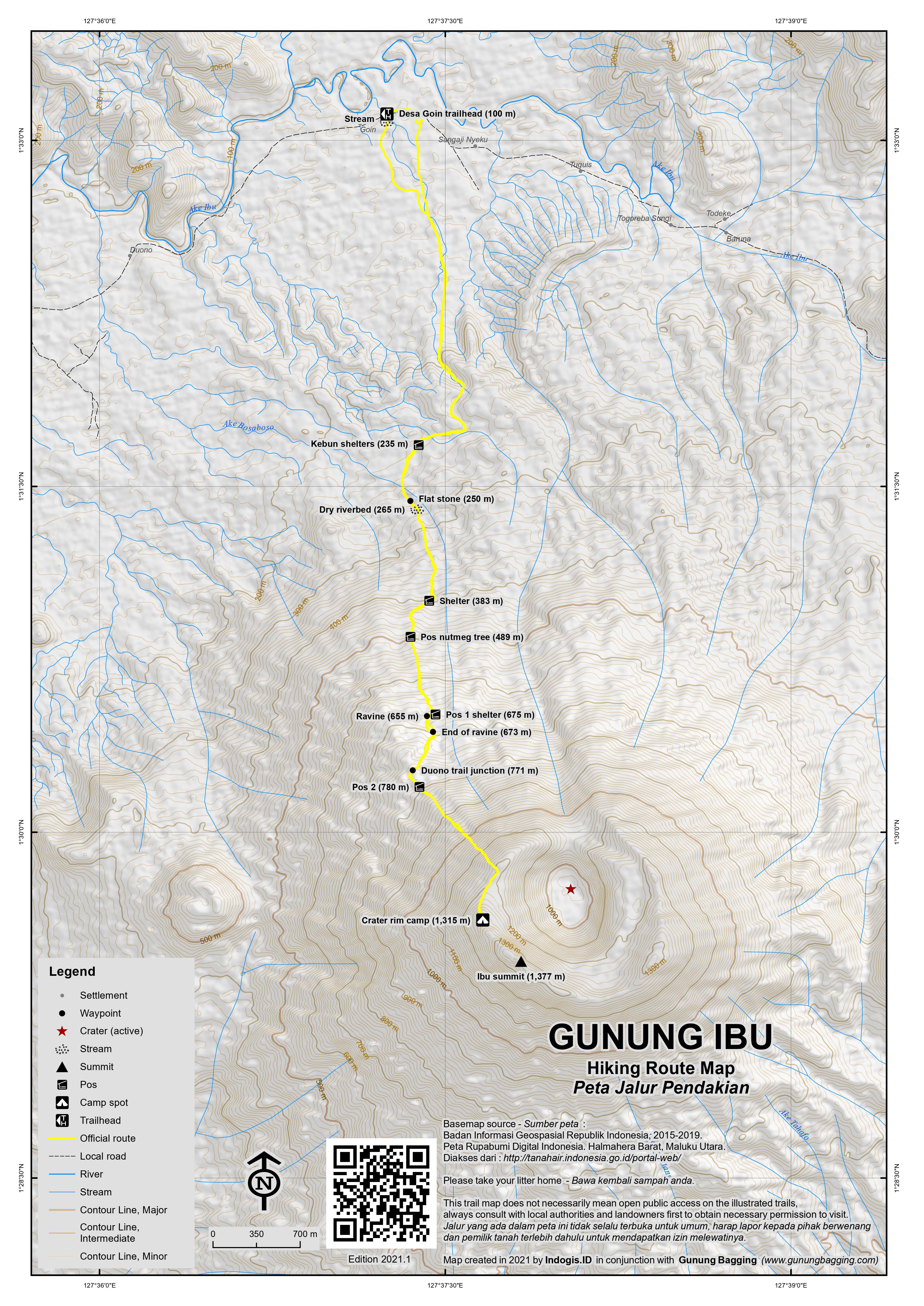
There are at least two villages to the north from where a hike can be started from – Desa Duono (108m) and Desa Goin (100m) – with the trails meeting at a junction approximately halfway up. The Desa Duono trail is better known and slightly more frequently used, but overall they require a similar amount of time and are also similar in character. Both trails involve several kilometres of fairly flat walking through extensive coconut plantations with numerous wooden shelters and it is often possible to take motorbikes two kilometres or so to an elevation of over 200 metres. The trail then passes through nutmeg and cloves plantations before entering the forest at about 600 metres.
On the Desa Goin trail, a pleasant wooden shelter known as Pos 1 (675m) is usually reached after around 2-3 hours and is a great place to rest for a while. This spot used to be used by pig hunters to prepare the meat before returning to the villages below. The Desa Goin route then drops down to a ravine (655m) which is filled with black sand and boulders, and is the best chance of a water source, but only if there has been rain recently. Depending on the activity and the wind direction, it is often here that you will first hear rockfall and volcanic activity up above. If hiking at night it is particularly eerie and remarkable. The Goin route involves following this ravine for a couple of hundred metres before crossing over to the right side and into proper forest (673m).
The Goin and Duono trails meet at an elevation of 771m, though there is no sign here and this crucial junction is easy to miss. A couple of small grassy areas soon follow, which Desa Goin guides call Pos 2 (780m). The volcanology sensor station is passed on the right at about 800 metres though it may be hidden in the vegetation. Beyond this point, until recent years the track is was rarely used and overgrown, but by 2021 is steep yet clearly defined, assuming another group has been up in recent weeks.
Eventually, the track emerges on the western side of rim at around 1250m with some spectacular views into the crater. Black rocks fill almost every possible part of the crater floor. Follow the trail on as it skirts the rim before reaching a great viewpoint on the rim which also doubles as a camping area (1,315m). In clear weather, the views from the camp spot to the western coastline and back south to Gunung Gamkonora are excellent.
An old sign suggests this is ‘Gunung Tabaru, 1325m’ though both the name and the elevation are debatable. But the views and the sounds are utterly breathtaking. The main active cone, which now dominates the scene, billows enormous plumes of smoke along with an immense ‘whoosh’ every 15 minutes or so, with ash being deposited on the surrounding forest. At night, you can see an amazing and unforgettable orange glow every time this happens.
Back in 2011, fumaroles emitted gas continuously with ear-deafening screams. But in 2021, between the eruptions from the cone, there is a ghostly quiet, with weird rockfall noises sounding like hundreds of bottles being simultaneously smashed, or huge quantities of slates in a slate mine sliding, or plates and cups destroyed, in various different locations. It’s like a bull in a china shop, or rather several bulls in several china shops creating utter havoc! But the dark colour of the rocks makes it quite difficult to spot where the rocks tumbling are actually located.
The outer crater rim has two high points, one on the west (which is apparently the summit) and a second on the eastern side. The old US Army map lists the western top as 1,325m and the eastern top as 1,300m but based on satellite data and personal GPS readings these old figures are underestimates. Because the track emerges onto the crater rim on the western side, it is technically possible to reach the summit on the highest part of the steep-walled valley though in 2021 this would still require huge effort cutting through dense ferns and cane grass.
Currently, no hikers go beyond the camp spot and viewpoint, as there is no trail. What appears to be the summit is obvious and clearly visible and if there were a trail is might only require another 20 minutes of hiking. But to create a trail to reach that point would take half a day! Note also that as mentioned above, if the dome continues growing then it will potentially become the new highest point of Gunung Ibu, replacing the outer rim summit.
According to one local guide, before the ongoing activity which started in 1998, local hunters could do a circuit of the crater rim and even descend into the crater itself. But this was back when trees grew on the rim rather than more troublesome vegetation such as the ferns and cane grass.
Note that some local hikers call this mountain Gunung Tobaru/Tabaru, but on the old US Army map, Gunung Tobaru is a 1,035 metre high peak several kilometres further north, and also known as Gunung Loloda. Gunung Ibu is named after the Ibu tribe who first inhabited the area near the volcano but are now found living around Desa Gamlamo and have long since converted to Islam. The Tobaru tribe, on the other hand, originate from the highlands around Gunung Tobaru, Lake Todoke and Lake Togotoaka and now live at the base of Gunung Ibu.
Allow 5-6 hours up and 3-4 hours back down to the villages.
Bagging information by Nick Hughes (September 2011), updated by Dan Quinn (October 2021)
Trail Map
For a high quality PDF version of this and other trail maps, please download from our Trail Maps page.
Practicalities
- Getting there: There are plenty of flights to Ternate island from Jakarta (usually via Manado and/or Makassar). From Ternate, take a speed boat from the Dufa-Dufa boat terminal just north of the airport, to Jailolo on mainland Halmahera (Rp60k per passenger in 2021, less than 1 hour). Arrange a hire car from Jailolo to Desa Duono or Desa Goin, Kecamatan Ibu (under 2 hours). Public transport is infrequent and unreliable though in 2021 there are plenty of drivers waiting for passengers to fill their vehicles up. It is advisable to stop enroute at the Pos Pengamatan Gunung Api (Vulcanology Post), Desa Gamsungi, for latest information on the eruptive status of Gunung Ibu. This Pos monitors Gunungs Gamkonora and Ibu.
- Guides and GPS Tracks: Want a PDF version for your phone? Looking for a guide? Need GPS tracks and waypoints? Gunung Ibu information pack can be downloaded here.
- Trip planning assistance: Would you like Gunung Bagging to personally help you in arranging your whole trip? Please contact us here.
- Permits: None required but take a photocopy of your passport photo page just in case. Check the eruptive status of Gunung Ibu at http://www.vsi.esdm.go.id/ The vulcanology officials are obliged to “close” the mountain to climbers when Stage 3 – Siaga (High Alert) – is reached.
- Water sources: None known except after heavy rainfall – take sufficient supplies with you.
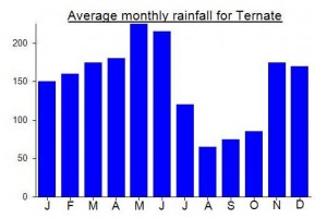
Local Average Monthly Rainfall (mm):
Location
Click on the blue arrow ![]() (top right) to see your current location on the map
(top right) to see your current location on the map
Origins and Meaning
‘Ibu’ means mother. So, “Mother Mountain” might be a reasonable translation.
https://www.theguardian.com/world/article/2024/may/19/indonesias-ibu-volcano-spectacularly-erupts-forcing-nearby-villages-to-evacuate
https://en.tempo.co/read/1865997/mount-ibu-in-eastern-indonesia-sees-rising-volcanic-activity-pvmbg
After having found a guide in neighbouring Desa Goin, I couldn’t resist going back for Gn Ibu. Members of Muslim Bule band Debu were on my flight to Ternate – some kind of bizarre omen for the trip!? Didn’t have to wait long at Dufa Dufa to get over to Jailolo…. Boats run daily until around 4pm in both directions. And in Jailolo these days there are usually drivers waiting to fill their cars with passengers heading to… wherever. Nobody else was heading to Ibu so I chartered a car for 300 plus a bonus 50 as Desa Goin is a further 20-30 minutes beyond Ibu. It makes sense to save your driver’s number and have him pick you up again afterwards. Otherwise, get an ojek to the market in Ibu where there is usually at least one car waiting for passengers back down to Jailolo.
Very friend folk in Desa Goin. I had some rest before we set out at 9pm. We didn’t take motobikes into the kebun, as we didn’t really need to save time on this occasion.
I was expecting to be using the trail from Desa Duono, not knowing that another one exists. But indeed there are loads of plantation tracks up from the villages in the direction of the volcano and a less commonly used trail from Goin up the volcano that meets the Duono trail just before the sensors.
Before this, there are lots of small wooden buildings on the Goin trail. Many in the plantations are used for small scale industrial purposes with the coconuts and one even had a couple of guys working in it at 10pm on a Saturday night! Pos 1 is the last shelter and like all the others would make a great place to rest or shelter from rain. I’m sure there are similar on the Duono trail but not sure how far up the trail.
After this point we first started to hear rockfall. When you’re wandering up a dry creek filled with black volcanic sand, hearing boulders hurtling down the mountainside above you at night is both disconcerting and exhilarating!
I was exhausted, having only had a couple of hours of rest since Jakarta, but we finally made it up onto the rim and could seek glowing orange down below in the crater and the eerie sounds of the ‘bull in a china shop knocking plates and bottles over’ that I write of above! Totally bizarre. Every 20 minutes came an eruption from the main cone, orange jets spraying out and a large cloud of fine ash drifting across the night sky. Unforgettable.
Despite being only 1,300m up, this spot is surprisingly cold at 4am and I woke to find myself shivering! The sun eventually rose on the far side of the crater, casting light onto this peculiar and strangely beautiful scene.
The locals said there was no trail beyond here up to the obvious high point just 500 metres or so south along the rim, but we gave it a try anyway. After ten minutes, we were only 20 metres further. So anyone wanting to bag what appears to be the highest point (at present, unless the cone continues its growth for several more years) will need lots of extra time and probably a lot of extra payment for your guides to cut a trail.
Very much worthwhile heading back for this one.
As I was coming to the Ibu area after having done Dukono I considered the cross-country route via Tolabit, requiring only 3 hours instead of 5 and a half on the long main road back round via Sidangoli and Jailolo. There is a surfaced road beyond Tolabit but you then need to walk 3 kilometres (at least, could be more) presumably on dirt track (certainly no car can use this route at present though a motorbike in dry conditions might be ok) to Togereba Tua where you can get an ojek on to Desa Duono. But given all the hassles of finding ojeks and so on I thought I’d see what the price was for a car round to Ibu, as like usual on Halmahera you can be waiting forever for a car to fill up with other passengers.
Terminal Baru in Tobelo is the place to find drivers typically from the Jailolo area, waiting to head home. At Rp800k it wasn’t cheap, but I was at the Penginapan Bionuri in Desa Ibu in about 5 and a half hours including a quick stop to eat at Rumah Makan Laduni. There is no data signal at the Penginapan, but it’s friendly and Rp130k a room.
I sent a message to Alex, a former guide for westerners visiting Gunung Ibu, to see if he had a number for his relative, Edwin, in Desa Duono, for the following day. No reply, so I just got an ojek up there at first light the following day (Rp50k, just under 30 minutes), ready with GPS, water and snacks. I was given a coffee at what I think was the Pak RT house near the football field / alun-alun. After a few minutes, a boy shuffled over. Turned out this was Edwin, but he looked tired and not very interested in doing a hike. Not inspiring of confidence. He said a day-hike was impossible, to which I replied it definitely was possible given I had a friend who had done it and that it was still before 7am so plenty of time. He asked for Rp800k, quickly changed to Rp1juta for two of them. He also looked up at the volcano as if it was the first time he had ever seen it, and was confused by how long it might take.
I said Rp500k should be enough for a dayhike and if he wanted to bring a friend it was up to him, but I wouldn’t be paying double for him to bring a friend. It is hiked frequently by local students now, so is likely to be far less overgrown than when Nick hiked it almost ten years ago to the day. My final offer of Rp600k was rejected and he shuffled off again. I waited to see if anyone else could be found, but nobody emerged after nearly an hour of sitting around waiting. Very disappointing. To be honest, I would have reluctantly agreed to a higher price if he had shown any enthusiasm, but he seemed totally lacking in energy and I wouldn’t have been surprised had we reached the edge of the rim if he had asked for yet more money to try to reach the highest point. When you are not only paying but also actually having to motivate a local guide in the first place it becomes incredibly tedious indeed.
Remember that standard minimum wage in the province is around Rp2,7 juta a month, so Rp600k for a day is pretty good going for work that is basically unskilled and could be done by anyone who had hiked the trail recently. Quite why it is expected that you should pay more than a week’s wages for a day-hike is unclear. Imagine turning your nose up at 360 quid in the UK for a dayhike. Personally if I knew the way I’d be quite happy to do the trek for Rp600k, no matter what country I was in. A shame also that they don’t seem to comprehend that you may have spent a lot of time and effort in just getting to the village.
So, one of his friends took me back to the penginapan in Desa Ibu (another 50k). I had already paid for a second night there, but decided to call the driver to get back to Jailolo and over to Ternate. 081241611533 is Bang Arya’s number if you need a driver in the Jailolo area. Desa Ibu to Jailolo is Rp300k for a car, and takes about 90 minutes. There was a speedboat filling up, Rp60k per ticket over to Dufa Dufa pier, or Rp1 juta if you want to charter!
Over in Ternate I looked into Kie Besi but given I needed a PCR test for my flight back to Jakarta, and the limited boat schedule, I ended up just staying at a hotel and resting. It was a disappointing end to the trip, and means that the very friendly Buku Sibela will be going in my eBook of 100 hikes in Indonesia instead of Gunung Ibu.
Perhaps I’ll return in a few months if there is any interest from others in doing a hike there and paying an over-the-top fee for it. In retrospect I could have tried searching for a willing guide another 1.5km further along at Desa Goin due north of the volcano. Perhaps that will be the plan next time. Do get in touch if you are interested in a Maluku Utara trip later in 2021….
Hello Nick,
Its really nice this information. I would like to climb this volcano. Can you tell me you need how many time of trekking from start point at village Duono to the top of Ibu?
Thank you for your consideration,
Abot