
Facts
- Elevation: 2,448 m (8,031 ft)
- Prominence: 1,130 m
- Ribu category:
 Tinggi Sedang
 - Province:
 Bengkulu
 - Coordinates: -2.7362, 101.9195
- Rating:
 (Bagged it? Be the first to rate it)
 Loading...
 - World Ribus ID: 69165
Bagging It!
We currently know very little about this peak – please contact us if you can provide any information. It is on the border with Jambi and may even be in Jambi. A US Army map gives a summit height of 2,446m, but SRTM gives a little higher at 2,448m.
Practicalities
-
- Getting there:Coming soon
- Permits: Coming soon
- Water sources: Coming soon
- Accommodation: Try the Booking.com map above or use this link to search for suitable hotels, homestays, resorts and apartments for your trip.
- We recommend Safety Wing as travel insurance for overseas travellers and tourists hiking up to elevations not exceeding 4500 metres.
Local Average Monthly Rainfall (mm): 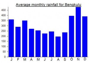
Location
Click on the blue arrow ![]() (top right) to see your current location on the map
(top right) to see your current location on the map
Origins and Meaning
‘Gedang’ means big or large in local Minangkabau language. So, “Big Mountain” is a fair translation.